MONTHLY CLIMATOLOGICAL SUMMARY for AUGUST 2004
NAME: 3270 Nowell CITY: West Juneau STATE: Alaska
ELEV: 97 ft LAT: 58° 17' 33" N LONG: 134° 25' 37" W
TEMPERATURE (°F), RAIN (in), WIND SPEED (mph), SNOW (in). Snowfall from 21:00 - 21:00, all others Midnight to Midnight.
HEAT COOL AVG WIND SNOW
MEAN DEG DEG WIND DOM RUN ON(1)
DAY TEMP HIGH TIME LOW TIME DAYS DAYS RAIN SPEED HIGH TIME DIR (mi) SNOW GRND WEATHER
-----------------------------------------------------------------------------------------------------------------------------------------------------
1 55.3 59.2 3:20p 52.0 5:10a 9.7 0.0 0.07 0.3 7.0 5:10p NE 6.82 0.0 0.0 Cldy Cld/FewSpr-Mist Cldy Cld/Rain
2 59.0 68.3 3:40p 51.6 4:55a 6.4 0.3 0.04 3.0 17.0 11:55a WSW 72.61 0.0 0.0 Cld/Rn Cld/Brks/Spr PCld MCld Cldy Cld/Rn
3 56.3 59.8 4:55p 53.3 12:00m 8.7 0.0 0.21 1.0 12.0 12:15a WSW 22.92 0.0 0.0 Cld/LtRn Cld Cld-LoClds/LtRn-Spr-Rn Cld/SmBrks
4 59.5 71.5 4:00p 51.6 5:15a 6.8 1.3 0.00 2.6 14.0 3:00p SSW 62.64 0.0 0.0 Cld Fog Pcldy Clear MostlyClr
5 59.6 69.1 11:55a 51.4 5:55a 5.8 0.4 TRACE 2.4 17.0 9:20a E 57.00 0.0 0.0 MClr-PCld Pcld-MCld Cld/Spr-LtRnShrs MCld
6 59.5 68.9 11:50a 53.3 5:25a 5.7 0.2 0.00 2.0 16.0 10:00a ENE 48.38 0.0 0.0 VarClds - MCldy to PCld/Clr MCld Cld MCld PCld
7 59.3 68.4 2:30p 50.2 4:10a 6.1 0.4 0.00 0.9 8.0 3:50p NNE 20.99 0.0 0.0 Var Clds from Mostly Clear to Mostly Cldy/Cldy
8 61.7 76.0 3:05p 51.0 5:10a 5.6 2.3 0.00 1.2 11.0 2:15p NE 29.91 0.0 0.0 Clr/PCld Clr MostClr-PCld MClr Clr
9 61.9 75.3 3:25p 50.4 5:45a 5.4 2.2 0.00 1.0 6.0 10:50p NNE 23.63 0.0 0.0 Totally Clear
10 63.3 76.7 5:05p 51.6 5:20a 4.3 2.6 0.16 1.4 19.0 8:15p S 34.41 0.0 0.0 Aur Clr MClr IncrCldDcrCld Cld Cld/RnShrs-ThundrStrm
11 61.2 66.6 12:05p 52.9 11:55p 3.9 0.2 0.15 2.1 12.0 2:40a SE 49.82 0.0 0.0 Cld/Rn VarCld-PCld/FewSpr MCld/Cld/PCld-Sun ThinClds
12 59.3 70.6 4:45p 49.5 5:55a 6.6 0.9 0.00 2.1 13.0 11:00a WNW 50.07 0.0 0.0 P/MCld with HiVryThinCld Ovcst MOvcst-WkSun MCld Cld
13 61.7 75.6 4:40p 48.3 5:35a 6.1 2.8 0.00 2.5 16.0 5:05p SW 59.81 0.0 0.0 Cloudy Cleared off before morn. Clear
14 64.6 81.6 4:45p 50.4 5:10a 4.9 4.4 0.00 1.8 12.0 9:25a SW 43.41 0.0 0.0 Clear MostlyClear Clear
15 65.8 78.8 11:30a 54.4 5:30a 3.2 4.1 0.00 1.2 11.0 10:25a NE 27.58 0.0 0.0 Clr MClr Clr/Smoke-Haze Clr/VerySmoky
16 66.3 79.4 12:05p 55.0 5:35a 2.8 4.2 0.00 0.9 10.0 10:55a NE 20.93 0.0 0.0 Clear with Smoke-Haze
17 65.0 76.8 3:10p 55.4 5:35a 2.9 2.9 0.00 1.2 12.0 1:40p ENE 28.83 0.0 0.0 Clr with Smoke-Haze Clr/ThinHz PCld Cloudy
18 61.2 65.6 5:25p 56.0 11:50p 3.8 0.0 0.11 0.5 7.0 2:30a E 11.38 0.0 0.0 Thundr-Lightng Cld/Rn-Mist Cld & P/MCld ThinHz P.M.
19 57.0 59.6 11:15a 54.5 11:55p 8.0 0.0 0.16 0.5 8.0 11:25a E 12.21 0.0 0.0 Cld/MCld Fog MCld Cld/LtRn-Spr Cld-Rn MCld Cld
20 56.6 61.0 5:45p 53.9 4:45a 8.4 0.0 0.12 0.2 5.0 3:40p NE 5.64 0.0 0.0 Cld/Shrs LoFg/Cld Fog Cld/Rn-Mst Cld/Brks P/MCld PCld
21 61.6 76.7 3:55p 52.8 5:00a 5.5 2.1 TRACE 2.9 19.0 2:55p WNW 69.23 0.0 0.0 Cld/LoCld-Fog Cld/Spr MCld PCld Clear
22 64.8 74.2 3:20p 50.4 12:00m 3.0 2.8 0.00 3.7 28.0 9:05a SW 87.94 0.0 0.0 Clear Clr/Brzy-Gusty MClr Clear
23 56.5 69.6 2:00p 45.8 5:50a 9.2 0.7 0.00 1.4 11.0 12:25p SW 34.11 0.0 0.0 Clear MostlyClear/Clear
24 58.5 68.6 3:30p 50.1 12:05a 7.0 0.5 0.00 1.5 12.0 4:55p SW 36.69 0.0 0.0 Clr Cld MClr P/MCld MClr Clr/PCld Clr HiHaze in P.M.
25 54.8 62.0 4:50p 46.5 6:05a 10.2 0.0 TRACE 1.2 11.0 2:10p SW 28.32 0.0 0.0 Hi&LwrHazeAllDay Clr PCLd Ovcst Cld M/PCld MCld/Spr
26 56.6 65.0 2:50p 52.2 3:05a 8.4 0.0 0.19 1.6 17.0 3:55p SE 38.82 0.0 0.0 Cld/SmBrks/ThinHz Cld M/PCld Cld/Spr/Shwr Cld/Rn
27 55.5 57.6 3:50p 53.2 8:55p 9.5 0.0 0.47 1.9 14.0 3:40a SE 45.27 0.0 0.0 Cld/LowClds/OccRn-Spr-Mist Some Sunshine
28 54.4 55.9 2:15p 53.1 2:25a 10.6 0.0 0.38 1.6 12.0 10:00a SE 37.16 0.0 0.0 Cldy Cld/Spr-LtRn-Mist-Rain Cld MtnTopsinCldsAllDay
29 55.6 64.5 2:40p 49.1 12:00m 9.4 0.0 0.00 1.3 11.0 12:35p WNW 32.15 0.0 0.0 Cld/MCld Fog Cld/MCld M/PCld PCldy RnBow P/MCld PCld
30 53.8 64.5 3:20p 45.5 6:00a 11.2 0.0 0.00 0.7 7.0 6:15p SW 17.04 0.0 0.0 P/MCld BrkOvcst PCld MostlyClear-ScatCumulus Clear
31 54.4 67.6 3:15p 44.8 6:30a 10.7 0.2 0.00 2.6 14.0 1:20p SW 63.46 0.0 0.0 Clear Clr/HiHaz-VryThinClds Pcld Clear VryThinHz-P.M.
------------------------------------------------------------------------------------------------------------------------------------------------------
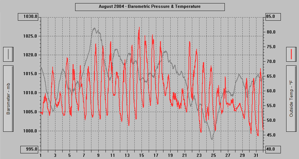
59.4 81.6 14 44.8 31 209.8 35.5 2.06 1.6 28.0 22 SW 1179.18
(1) As measured on Front Lawn
AVERAGE Mean Temp: 59.4
AVERAGE High Temp: 68.9
MINIMUM High Temp: 55.9 28th
MAXIMUM High Temp: 81.6 14th
AVERAGE Low Temp: 51.3
MINIMUM Low Temp: 44.8 31st
MAXIMUM Low Temp: 56.0 18th
MAX >= 90.0: 0
MAX >= 80.0: 1 14th
MAX >= 70.0: 12 4th, 8th - 10th, 12th - 17th, 21st, 22nd
MAX <= 32.0: 0
MIN <= 32.0: 0
MIN <= 0.0: 0
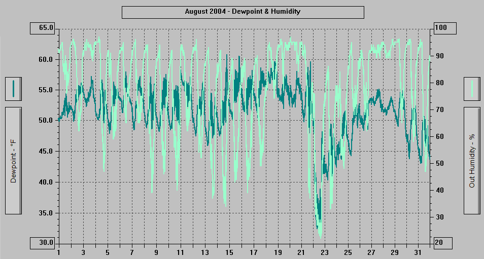
MAXIMUM Humidity (%): 97 4th @ 0628, 20th @ 0208
MINIMUM Humidity (%): 22 22nd @ 1346
MAXIMUM Pressure (mb): 1027.2 8th @ 1059
MINIMUM Pressure (mb): 997.7 24th @ 1844
TOTAL Htg Deg Days: 209.8
AVERAGE Htg Deg Days: 6.8
MINIMUM Htg Deg Days: 2.8
MAXIMUM Htg Deg Days: 11.2 16th
TOTAL Cool Deg Days: 35.5 30th
MAXIMUM Cool Deg Days: 4.4 14th
Heat Base: 65.0 Cool Base: 65.0 Method: Integration
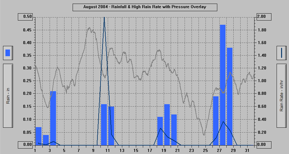
TOTAL Precip.: 2.06
AVERAGE Precip.: 0.1
DAYS OF Precip.: 14
MAXIMUM Precip.: 0.47 27th
MAXIMUM Rain Rate: 2.00" per hour on the 10th @ 2322
Days of Rain: 11 (>.01 in) 9 (>.1 in) 0 (>1 in)
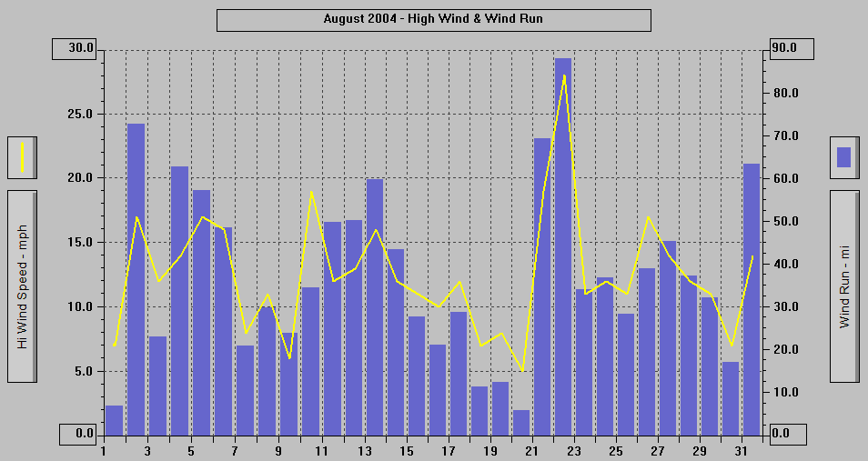
AVERAGE High Wind: 12.5
MINIMUM High Wind: 5 20th
MAXIMUM High Wind: 28 22nd
WIND RUN (miles): 1179.18
DAYS OF Sun: 27
DAYS OF Cld or M Cld: 23
DAYS OF Rainbow: 1 29th
DAYS OF Aurora: 1 10th
DAYS OF Lightning: 2 10th, 18th
DAYS OF Earthquake: 1 3rd
| NWS Record Report for August 17 |
| Statement as of 10:00 PM ADT on August 17,
2004 ... More record high temperatures for Southeast Alaska Tuesday... Location new record old record year set Yakutat 72 69 1997 Hoonah 76 76 1984 Juneau 78 76 1977 Petersburg 75 74 1957 Wrangell 72 69 1997 Pes Aug 04 |
| LIGHTNING EVENTS - Juneau, Alaska - September 1983 to August 18, 2004 | |
| 2004 August 18, 0300 - 0341 | |
| 2004 August 10, 2148-2326 | |
| 2004 July 24 afternoon 1334-1409 | Most Powerful Lightning Storm at 3270 since before 1970 |
| 2004 July 24 morning at 1027 | |
| 2004 June 27-28 night from 2318 6/27 to - 0010 6/28 | |
| 2004 June 27, 0149 to +0245 | Heat Lightning - no thunder heard |
| 2003 September 24 at 0756 | |
| 2001 March 12 | Northern part of the Borough |
| 2000 September 14 at 0357 | |
| 2000 June 28 afternoon | |
| 1998 August 29 | |
| 1997 June 23, 1402-1429 | To ESE, E, ENE, NE |
| 1995 June 4 afternoon, .13" 1541-1547 | Best display to this point since start of records Feb. 1970 |
| 1993 June 5 at 1943, 1944, and 1946 | |
| 1991 July 24 | |
| 1987 July 13 | Mendenhall Valley only |
| 1986 July 17, 1930-2000 mostly SW over Doug.I., 2016-2108 | At 2056 to E over Mt. Roberts, Hail and Rain 2107. Closest 1.9 mi. |
| None between September 1, 1983 and July 17, 1986 | |
| February 16, 1970 to September 1, 1983 | In records but have to extract - many years between events |
| NWS Special Weather Statement |
| Statement as of 6:00 PM ADT on August 15,
2004 ... Smokin' hot over Southeast Alaska today... Very warm air over the southern Yukon and interior Alaska along with low level winds out of the north combined to bring a double whammy of smoke and record high temperatures to the Panhandle. Dense smoke from the widespread forecast fires over The Interior funneled through the valleys and mountain passes and has been reducing visibilities to 2 to 3 miles over the northern Panhandle. Satellite pictures show the smoke extending as far south as Frederick Sound this afternoon. Another consequence of the north winds is an enhanced warming of The Interior air as it descends to sea level. Numerous stations from Skagway to Wrangell set record highs today. Temperatures soared to 88 at both Skagway and Yakutat. The 88 at Yakutat was also the hottest temperature ever recorded since official records began in 1948. The previous record was 87 in 1995. Stations reporting record highs today included: location new record old record year set Yakutat 88 73 1950 Skagway 88 77 1996 Juneau 83 81 1957 Gustavus 84 83 1957 Hoonah 87 76 1997 Sitka 82 75 1957 Wrangell 79 74 1991 Todays 83 degrees at the Juneau Airport also broke the record for the number of days in a Summer of 70 degrees or higher. Today was the 36th day to reach the mark in 2004... 4 in May... 13 in June... 10 in July... and 9 so far in August. The previous record was 35 days in 1989. The record is likely to be extended at least 1 or 2 more days this week. The 10 days of 80 degrees or above this Summer is also a record... easily beating the 7 days in 1951. Smoke will continue to be a problem for the northern half of the Panhandle until the winds switch to the south or precipitation moves in. The light northerly flow continues at least through Monday and the current forecast does not have a chance of significant precipitation for the northern Panhandle until Tue. |
| NWS Record High Temperature Report |
| Statement as of 6:30 PM ADT on August 10, 2004 ... Record temperature... Location new record old record year set Skagway 81 79 1987 Sitka 83 78 1993 Hoonah 83 75 2003 Juneau 84 82 1957 Petersburg 82 79 ** 1987 Wrangell 81 74 ** 1997 ** both of these cities the climate database at the current location covers less than ten years. The community of Gustavus and Hoonah both reported temperatures in the 80's today but were not a record for this date. Also this is the tenth time that the official temperature at the Juneau Airport reached or exceeded 80 degrees this Summer. This exceeds the old record of seven days in the Summer of 1951 with temperatures in the 80's. While today is only the second time Skagway got into the 80's this Summer their record number of days in the 80's is fourteen. This was set in 1929... which is before the official Juneau Airport database began. Although... in 1990 Skagway reported thirteen days with temperatures in the 80's while during that same time the Juneau Airport reported a total of six days. Another warm spot this Summer is Haines with nine days in the 80's. Their warmest Summer was in 1977 with 20 days in the 80's. Aug 04 |