MONTHLY CLIMATOLOGICAL SUMMARY for MAY 2005
CONDITIONS DAY of
Month: 1 2 3 4 5 6 7 8 9 10 11 12 13 14 15 16 17 18 19 20 21 22 23 24 25 26 27 28 29 30 31
NAME: 3270 Nowell   CITY: West Juneau   STATE: Alaska
ELEV:    97 ft  LAT: 58° 17' 33" N  LONG: 134° 25' 37" W


TEMPERATURE (°F), RAIN  (in), WIND SPEED (mph), SNOW (in). Snowfall from 21:00 - 21:00, all others Midnight to Midnight.

                                      HEAT  COOL        AVG                      WIND       SNOW
    MEAN                              DEG   DEG         WIND                DOM  RUN        ON(1)
DAY TEMP  HIGH   TIME   LOW    TIME   DAYS  DAYS  RAIN  SPEED HIGH   TIME   DIR  (mi)  SNOW GRND WEATHER
-----------------------------------------------------------------------------------------------------------------------------------------------------
 1  52.1  60.2   4:35p  41.2  11:45p  12.9   0.0  0.00   4.3  25.0   9:50a   NE 104.19  0.0  0.0 Cld/MCld Brzy VarMCld-CldtoPCld VarPCld-Clr IncrCld
 2  51.4  63.4   3:25p  40.6   1:25a  13.6   0.0  0.00   1.9  12.0   7:55a   SW  44.82  0.0  0.0 MCld-Ovcst OvcstwThinAreas PCld Cld BrknSky Cld/MCld
 3  49.5  55.6  12:10p  45.5   5:20a  15.5   0.0  0.03   1.1  14.0   4:40p   SE  25.56  0.0  0.0 Cld/MCld Cld-PCld Cld-SmBrk/LtRn-Rn Cld-SmBrk/OccSpr
 4  48.0  53.9   9:45a  44.2   2:55a  17.0   0.0  0.06   1.3  11.0  10:10a  SSW  30.74  0.0  0.0 Cld/MCld PCld MCld-Cld/LtRn-Rn-Spr Cld MCld/Cld
 5  50.0  60.2   3:10p  39.3   5:45a  15.0   0.0  0.00   3.1  13.0   1:45p  WNW  74.64  0.0  0.0 M/PCld Clear with some scattered clds Clear
 6  52.6  67.9   3:20p  36.2   4:50a  12.8   0.4  0.00   2.7  19.0   1:35p   SW  65.29  0.0  0.0 Clr BrzyinAfternoon Clr/PcldwHiThinVryThin MClr Clr
 7  54.6  71.3   3:10p  38.9   5:05a  11.3   0.8  0.00   1.9  10.0   4:35p   SW  44.60  0.0  0.0 Clr/MClr PCldNWsky/MClrSE VarHiThinVryThinClds-Haze
 8  54.5  70.4   4:45p  39.2   4:10a  11.1   0.6  0.00   1.7  10.0   9:00a   SW  39.91  0.0  0.0 Clear Clr ButwithHaze/FilteredSuninLateAfternoon/Eve
 9  56.8  72.8   3:25p  41.3   5:05a   9.6   1.4  0.00   2.1  12.0   3:45p   SW  49.27  0.0  0.0 ClearButVryThinOvcst/Haze Haze-Filteredsun ThinHaze
10  57.2  72.3   4:00p  41.2   4:50a   9.2   1.4  0.00   1.4  11.0   8:35p   NE  34.03  0.0  0.0 Clear-SlightHaze VarPcld&MCld with HiThinVryThinClds
11  55.4  65.0  10:00a  47.0   3:10a   9.6   0.0  0.00   1.8  19.0  10:45a   SE  42.47  0.0  0.0 Cld Cldy/Brks PCld Cld/MCld Haze&Pollen PCld Ovcst
12  52.5  57.6  11:05a  49.1  12:30a  12.5   0.0 TRACE   1.1  10.0   9:40a   SE  27.18  0.0  0.0 Overcast Cloudy/LtSprinkling Cld Cld/Spr Cldy
13  54.5  62.7   2:50p  48.8   3:35a  10.5   0.0  0.07   0.8  13.0   4:40p   SE  18.87  0.0  0.0 Cld/OccLtRn-Spr Cld-MCld/Sun P/MCldy Cld/OccSpr LtRn
14  53.6  63.4   2:15p  47.6  12:00m  11.4   0.0  0.43   1.9  19.0   5:30p   SE  44.27  0.0  0.0 Cld/LtRn-Driz-Spr ThinFg Cld-MCld-PCld/Shrs SunInOut
15  52.2  59.9   1:35p  43.1   5:40a  12.8   0.0  0.01   1.9  14.0  11:30a    W  45.03  0.0  0.0 Cld/Shrs MClr IncrCld Ovcst ThinCld Cld Rnbw VarClds
16  51.9  59.5   3:40p  45.2   1:50a  13.1   0.0  0.04   1.4  18.0   7:45p    E  34.35  0.0  0.0 Cld/Shr Cld/LtRn-Spr Cld/MCld/PCld Shr-Rnbw Cld/Shr
17  52.4  63.9   2:15p  39.9   5:05a  12.6   0.0 TRACE   1.8  10.0   6:20p   NE  44.24  0.0  0.0 Cld/MCld/TrcRn BrknClds PCld/Clear MClr Clr
18  56.7  71.1   3:10p  38.8   4:50a   9.6   1.3  0.00   3.7  24.0  10:20a   SW  89.30  0.0  0.0 MClr-PCld PCld-HiThin&VryThin/Clr MClr PCldy
19  51.6  56.0   4:35p  44.2   3:55a  13.4   0.0  0.06   2.2  19.0   9:05p  ESE  52.01  0.0  0.0 PCld/Clr ThinCld MCld Cld/Ovcst/Rn Cld/Brks PCld Cld
20  54.4  61.8  10:40a  47.0   4:20a  10.6   0.0  0.02   1.8  19.0   5:00p  ESE  42.40  0.0  0.0 MCld/BitRn VarCld-Clear VarPCld-Cld/BriefShrs Rnbws
21  51.3  59.2   4:20p  42.8  11:20p  13.7   0.0  0.02   1.9  12.0   3:20a  ESE  46.76  0.0  0.0 Cld/OccSpr Cld/FewShr Cld/Brks M/PCld Rnbws PCld Clr
22  57.3  70.9   3:30p  43.2  12:05a   8.9   1.2  0.00   4.2  21.0   6:50a    W 101.05  0.0  0.0 Clear Brzy HiThin/VryThin MClr Clr/PCld VarPCld/MCld
23  54.2  63.5   1:45p  47.7   5:05a  10.8   0.0  0.21   1.5  14.0   3:20p   SE  36.86  0.0  0.0 PCld MCld Cld/OccLtRn-Spr Cld/Brks HvyRn Cld/TinyBrk
24  50.6  52.3   8:30a  47.9  11:35p  14.4   0.0  0.08   0.7  10.0   1:50p    E  17.12  0.0  0.0 Cld/OccRn Cld/SomeFog-CldArndMtns VryLtRnDriz OccSpr
25  54.3  64.0   3:05p  43.8   4:45a  10.7   0.0 TRACE   1.3  12.0   2:50p   NE  31.74  0.0  0.0 Cld PCld/Clr Fog ThinVryThinClds PCld Cld/Ovcst Spr
26  56.6  64.7   2:15p  48.6   4:45a   8.4   0.0  0.09   2.0  14.0  10:10p    W  47.73  0.0  0.0 CldyOvcst Cld-WeakSun PeriodofRain Cld/Ovcst Cld Rn
27  53.5  59.0   1:40p  46.8  12:00m  11.5   0.0  0.02   2.0  13.0   6:40a    W  47.05  0.0  0.0 Cld/Rn Cld M/PCld OccLtRn-Spr Cld Cld/LtRn-Driz Cld
28  56.2  68.8   3:55p  40.8   5:05a   9.2   0.4  0.00   2.5  14.0   7:35a   SW  60.02  0.0  0.0 Cld MostlyClear PCld MClr PCld MCld-HiThinCld Cldy
29  53.9  60.2  12:40p  50.5   4:25a  11.1   0.0  0.06   1.9  16.0   2:10p   SE  46.52  0.0  0.0 Cld/OccRain Cld/SmallBrks Cldy Cld/Spr/LtRn
30  52.1  56.5   2:40p  44.2  12:00m  12.9   0.0  0.21   1.4  10.0  12:30a   SE  33.85  0.0  0.0 Cld/Rn LoClds/Spr-LtRn-Rn Cld/Rn-LtRn DecrCld MClear
31  54.2  65.5   3:40p  40.3   4:15a  10.8   0.0  0.00   3.1  18.0  10:55a    W  74.39  0.0  0.0 Clr/MClr SomeFog Clr PCld HiThinVryThinOvcst WeakSun
-----------------------------------------------------------------------------------------------------------------------------------------------------
    53.4  72.8     9    36.2     6   366.5   7.5  1.41   2.0  25.0     1    SW 1496.53

(1) As measured on Front Lawn
STATISTICS | DATA | GRAPHS | CONDITIONS - DAY of MONTH: 1 2 3 4 5 6 7 8 9 10 11 12 13 14 15
16 17 18 19 20 21 22 23 24 25 26 27 28 29 30 31| TOP
AVERAGE Mean Temp: 53.4
AVERAGE High Temp: 63.0
MINIMUM High Temp: 52.3 24th
MAXIMUM High Temp: 72.8 9th
AVERAGE Low Temp: 43.7
MINIMUM Low Temp: 36.2 6th
MAXIMUM Low Temp: 50.5 29th
MAX >= 90.0: 0
MAX >= 80.0: 0
MAX >= 70.0: 6 7th, 8th, 9th, 10th, 18th, 22nd
MAX <= 32.0: 0
MIN <= 32.0: 0
MIN <= 0.0: 0
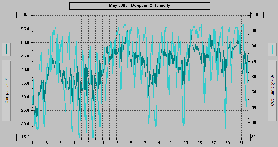
MAXIMUM Humidity (%): 95 14th @ 0527
MINIMUM Humidity (%): 19 9th @ 1517
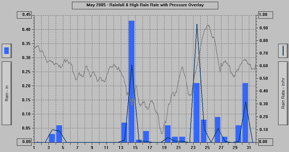
MAXIMUM Pressure (mb): 1031.3 25th @ 0159
MINIMUM Pressure (mb): 988.4 18th @ 1529
TOTAL Htg Deg Days: 366.5
AVERAGE Htg Deg Days: 11.8
MINIMUM Htg Deg Days: 8.4 26th
MAXIMUM Htg Deg Days: 17.0 4th
TOTAL Cool Deg Days: 7.5 (6th - 10th, 18th, 22nd, 28th)
Heat Base: 65.0 Cool Base: 65.0 Method: Integration
TOTAL Precip.: 1.41
AVERAGE Precip.: 0.1
DAYS of Precip.: 18
MAXIMUM Precip.: 0.43 14th
MAXIMUM Rain Rate: 0.93 23rd @ 1532
Days of Rain: 14 (>.01 in) 3 (>.1 in) 0 (>1 in)
TOTAL Snowfall: 0.0
DAYS of Snowfall: 0
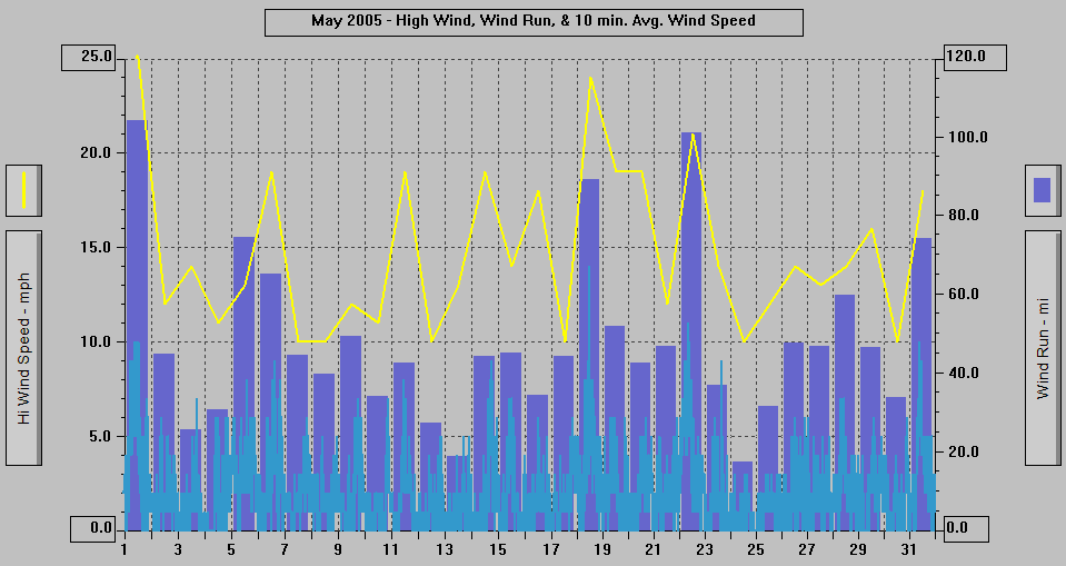
AVERAGE High Wind: 14.7
MINIMUM High Wind: 10 7th, 8th, 12th, 17th, 24th, 30th
MAXIMUM High Wind: 25 1st @ 0948
WIND RUN (miles): 1496.53
DAYS OF Sun: 28 All but 6th - 8th, 18th
DAYS OF Cld or M Cld: 27 All but 12th, 24th, 29th
DAYS OF Rainbow: 4 15th, 16th, 20th, 21st
DAYS OF Aurora: 0 If there was any: either cloudy, skies too bright, or missed it.
DAYS OF Lightning: 0
DAYS OF Earthquake: 0

5/31/05: DATA | KINY Radio 70th Anniversary. | Now: Weather Data for WAP enabled phones & other wireless
devices, includes NWS Juneau Data WAP link.
- 2050 ADT: High thin and very thin clouds
over most of the sky with some blue visible,
weakened sunshine.
- 1950: High thin and very thin clouds with
blue visible through the thinner areas, weakened
sunshine.
- 1850: Overcast with high thin and very thin
clouds and blue visible in the thinner areas,
weakened sunshine.
- 1750: High thin overcast with hints of blue
visible through the clouds in areas, weakened
sunshine
- 1650: High somewhat thin overcast, extremely
weak sunshine.
- 1550: High thin overcast with weak sunshine.
- 1450: High thin overcast with thinner clouds
in the NW part where blue is visible, weak
sunshine, halo around the sun.
- 1350: High thin overcast with thinner areas
in the NW part where some blue is visible,
weakened sunshine, a few lower cumulus clouds.
- 1250: High thin overcast with thinner areas
in the NW part where some blue is visible,
weakened sunshine, a few lower cumulus clouds.
- 1150: High thin overcast with some areas
thin enough for a hint of blue, weakened
sunshine.
- 1050: High thin and very thin overcast with
more blue visible through the clouds to the
NW, breezy, a few lower cumulus clouds, weakened
sunshine.
- 0950: Mostly overcast with high thin and
very thin clouds (blue visible through the
thinner clouds), weakened sunshine, a few
small lower cumulus clouds.
- 0920: Mostly overcast with high thin and
very thin clouds (blue visible through the
thinner clouds), thicker in E and SE part
of sky, weakened sunshine.
- 0850: Partly Cloudy with high thin and very
thin clouds/haze, clouds thicker to the E
and SE, weakened sunshine.
- 0750: Partly Cloudy with high thin and very
thin clouds/haze, clouds thicker to the E
and SE, weakened sunshine.
- 0735: Partly Cloudy with high thin and very
thin clouds/haze, clouds thicker to the E
and SE, weakened sunshine.
- 0650: Clear with the exception of high thin
clouds in the eastern and SE part of the
sky.
- 0620: Mostly Clear with high thin clouds
to the ENE, ESE, SE, wisps of fog blowing
from the NW to the SE.
- 0503: A cruise ship foghorn is sounding (foggy
over Gastineau Channel).
- 0313 ADT: Crows are pestering a Raven.
5/30/05: Memorial Day - see below | DATA | Weather Data is now available for WAP enabled phones
& other wireless devices.
- 2050 ADT: Mostly Clear.
- 1950: Clear/Partly Cloudy.
- 1935: Partly Cloudy/Clear.
- 1850: Partly Cloudy but with high very thin
clouds/haze in the "clear" areas.
- 1750: Mostly/Partly Cloudy a few wisps and
bits of fog/clouds around the mountaintops.
- 1720: Cloudy with slightly broken clouds,
some fog/clouds around the top of Mt. Roberts
and some wisps and bits in the inner Gold
Creek valley.
- 1650: Extremely Light Sprinkles occasionally,
cloudy with a bit of fog/clouds around the
mountaintops.
- 1550: Extremely Light Sprinkling, Cloudy
with a bit of fog/clouds around the upper
parts of the mountains.
- 1450: Cloudy with fog/clouds around the top
of Mt. Juneau and Mt. Roberts, a few breaks
to the NNW.
- 1420: Cloudy with small breaks, sun breaking
through the clouds, some lower bits and wisps
of fog/clouds.
- 1350: Sprinkling, Cloudy with a few lower
wisps and bits of fog/clouds.
- 1250: Light Rain, Cloudy with some fog/clouds
in Last Chance Basin, in the inner Gold Creek
valley and skimming the top of Mt. Roberts.
- 12:00: Memorial Day observance at Sealaska
Plaza.
- 1150: Rain, Cloudy with fog/clouds around
the mountaintops and in the inner Gold Creek
valley.
- 1120: Rain, Cloudy with the mountaintops
in the clouds.
- 1100: Memorial Day observances at Evergreen
Cemetery, Alaskan Memorial Park, & Shrine
of St. Terese.
- 1050: Very Light Sprinkling, Cloudy with
fog/clouds around the upper parts of the
mountains and hiding the inner Gold Creek
valley.
- 1005: Cloudy with fog/clouds around the mountains
- 1005: An Orange Crowned Warbler is in the
backyard.
- 0950: Light Rain, Cloudy with fog/clouds
around the mountains (highly variable).
- 0935: Sprinkling, Cloudy with clouds in last
Chance Basin and the upper portions of the
mainland mountains in the clouds .
- 0905: Rain, Cloudy with low clouds hiding
Mt. Juneau, Last Chance Basin, and the top
of Mt. Roberts.
- 0850: Light Rain, Cloudy with the inner Gold
Creek valley hidden, top of Mt. Roberts in
the clouds, and a lower band of fog/clouds
hiding most of Last Chance Basin and the
middle portion of Mt. Juneau.
- 0805: Rain, Cloudy with low clouds as low
as 400' hiding Mt. Juneau, Last Chance Basin
and the top of Mt. Roberts.
- 0750: Sprinkling/Misting-Light Drizzle, Cloudy
with low clouds as low as 400' hiding most
of the mainland (lower part of Mt. Roberts
has been more visible since 0620).
- 0735: Misting, Cloudy with low clouds as
low as 400' hiding most of the mainland,
some thin fog in part of Blueberry Hills.
- 0650: Cloudy with low clouds as low as 400'
hiding most of the mainland.
- 0620 ADT: Cloudy with low clouds as low as
200'-300' hiding most of the mainland mountains.
SUNDAY 5/29/05: DATA | May 1990 Rain Data has been corrected
to show 2.67" for c.y. 1990 total of
84.69" (rather than 2.21" and 84.23").
- 2050 ADT: Light Sprinkling, Cloudy with the
mountaintops in the clouds.
- 2011: 3 - 5 Bald Eagles including 1 to 3
immature flying around.
- 1950: Light Sprinkling, Cloudy with the mountaintops
in the clouds (lower on Mt. Juneau).
- 1920: Very Light Sprinkling, Cloudy.
- 1850: Cloudy with the top of Mt. Juneau,
very top of Mt. Juneau Ridge and Mt. Roberts
in the clouds, light precipitation over the
mainland.
- 1815: 2 immature Bald Eagles flew SW low
over the house.
- 1750: Cloudy with fog/clouds around the very
top of Mt. Juneau, clouds skimming the Mt.
Juneau Ridge and Mt. Roberts.
- 1650: Cloudy with the very tops of the mountains
in the clouds.
- 1635: Cloudy with very tops of the mountains
in the clouds except for part of Mt. Roberts.
- 1605: Cloudy with the clouds skimming the
mountaintops, the very top of part of Mt.
Roberts in the clouds.
- 1350: Cloudy.
- 1250: Cloudy.
- 1150: Cloudy with an area of breaks overhead
a bit to the NW, bright areas.
- 1050: Cloudy with a small break to the ENE,
bright areas.
- 0950: Cloudy with a break overhead and hints
of breaks, bright spots.
- 0850: Cloudy.
- 0750: Cloudy, a few lower wisps over Last
Chance Basin.
- 0650: Cloudy, a few lower wisps.
- 0620 ADT: Cloudy (overcast) with a tiny cloud
over Last Chance Basin. .04" of rain
since midnight.
- 2050 ADT: Cloudy - overcast with thinner
clouds NW part of sky and some thicker clouds
in the SE part.
- 2020: Cloudy SE part of sky, high thin overcast
NW part, very weak sunshine on Mt. Roberts
and upper half of Mt. Juneau.
- 1950: Cloudy with somewhat thin clouds SE
part of sky, overcast NW part with high thin
and very thin clouds, partial halo around
the sun, weak sunshine on Mt. Roberts and
upper half of Mt. Juneau.
- 1920: Cloudy with somewhat thin clouds SE
part of sky, overcast NW part with somewhat
thin clouds and large area of high very thin/thin
clouds.
- 1850: Mostly Cloudy with large area of very
thin clouds/haze where blue is visible and
other areas of broken clouds, somewhat weakened
sunshine.
- 1750: Mostly Cloudy with clear sky far to
the NW and high thin and very thin clouds
in the eastern part of the sky, somewhat
weakened sunshine.
- 1650: Partly/Mostly Cloudy with a large cloud
covering much of the central part of the
sky and high thin and very thin clouds elsewhere,
sun shining here and there on the mainland.
- 1550: Partly Cloudy SE half of sky, mostly
clear NW part (all with high thin and very
thin clouds).
- 1450: Mostly Clear.
- 1350: Mostly Clear, high thin clouds to the
SE.
- 1250: Mostly Clear.
- 1150: Partly Cloudy with cirrus clouds, thicker
clouds in the NW part of the sky.
- 1050: Mostly Clear.
- 0950: Mostly Clear.
- 0850: Clear with a few high thin clouds to
the SE.
- 0750: Mostly Clear.
- 0650: Mostly Clear.
- 0620 ADT: Mostly Clear.
- 2050 ADT: Cloudy with thinner areas, a few
lower wisps in Last Chance Basin and the
inner Gold Creek valley.
- 2035: Light Rain/Drizzle, Cloudy with some
fog/clouds in the inner Gold Creek valley.
- 1950: Cloudy with a few wisps and bits of
fog/clouds around the top of Mt. Juneau and
in the inner Gold Creek valley, a few wisps
in Last Chance Basin.
- 1920: Cloudy with a bit of fog/clouds around
the top of the Mt. Juneau Ridge and a few
wisps around the top of Mt. Juneau, thinner
areas in the SE part of the sky where blue
is visible through the clouds.
- 1905: Very Light Rain, Cloudy with a bit
of fog/clouds and wisps around the mountaintops.
- 1850: Light Rain, Cloudy, a few wisps around
the top of Mt. Juneau.
- 1820: Cloudy, a few wisps around the top
of Mt. Juneau.
- 1750: Sprinkling, Cloudy.
- 1735: Sprinkling, Cloudy.
- 1720: Cloudy.
- 1705: Light Rain, Cloudy.
- 1650: Cloudy.
- 1635: Light Rain, Cloudy.
- 1605: Sprinkling, Cloudy with a few thin
spots to the ENE where blue is visible.
- 1550: Light Rain, Cloudy with a bit of blue
sky to the East and a few small breaks to
the North.
- 1520: Cloudy with a few tiny breaks.
- 1505: Cloudy with a few small breaks and
some thinner areas, bright areas, weakened
sunshine
- 1450: Rain, Cloudy, bright sky in areas with
the location of the sun visible.
- 1435: Light Rain, Cloudy.
- 1420: Very Light Sprinkling, Cloudy.
- 1350: Light Rain (began 1347), Cloudy.
- 1335: Cloudy with a few small breaks to the
East.
- 1250: Extremely Light Sprinkling, Cloudy
with a few small breaks in the SE part of
the sky, location of the sun is visible.
- 1235: Sprinkling, Cloudy with a break to
the East, location of the sun is visible.
- 1220: Light Rain, Cloudy with a few small
breaks.
- 1150: Cloudy with some bright spots.
- 1050: Cloudy.
- 1020: Cloudy.
- 1005: Cloudy with a few tiny breaks.
- 0950: Cloudy/Mostly Cloudy.
- 0920: Mostly/Partly Cloudy SE half of sky,
cloudy NW part, sun is shining.
- 0858: 2 Bald Eagles swooping around with
each other.
- 0850: Cloudy.
- 0750: Cloudy.
- 0650: Cloudy with thinner areas, weakened
sunshine.
- 0620 ADT: Mostly Cloudy with areas of thinner
clouds, weakened sunshine. .05" of rain
overnight.
- 2050 ADT: Cloudy.
- 1950: Cloudy.
- 1920: Cloudy.
- 1850: Cloudy - overcast, location of the
sun is visible.
- 1750: Cloudy - overcast, location of the
sun is visible.
- 1650: Cloudy, location of the sun is visible.
- 1550: Cloudy.
- 1450: Cloudy.
- 1435: Cloudy - overcast.
- 1350: Cloudy with fairly bright sky, extremely
weak sunshine.
- 1250: Cloudy - overcast, location of the
sun is visible.
- 1150: Extremely Light Sprinkling, Cloudy,
location of the sun is visible.
- 1135: Very Light Sprinkling, Cloudy.
- 1053: Smoke from land clearing in the Lemon
Creek Valley over the Channel.
- 1050: Cloudy with a few lower wisps, location
of the sun is visible.
- 1035: Extremely Light Sprinkling, Cloudy,
a few lower wisps, fairly bright sky.
- 1020: Light Rain, Cloudy.
- 1005: Sprinkling, Cloudy.
- 0950: Rain, Cloudy.
- 0920: Rain (began 0916), Cloudy.
- 0850: Cloudy.
- 0750: Cloudy.
- 0720: Cloudy.
- 0650: Cloudy with thinner spots where blue
is visible through the clouds, extremely
weak sunshine.
- 0620: Cloudy - High Thin Overcast with thinner
areas, sun shining through a large area of
thinner clouds.
- 0343: Crows arrived and making a racket.
- 0333 ADT: A Bald Eagle is squealing.
- 2050 ADT: Cloudy with some light precipitation
in the inner Gold Creek valley.
- 1950: Cloudy.
- 1905: Very Light Sprinkling, Cloudy.
- 1850: Cloudy - overcast.
- 1750: Cloudy - overcast.
- 1650: Cloudy - with somewhat thin overcast.
- 1620: Cloudy.
- 1550: Cloudy/Mostly Cloudy.
- 1535: Cloudy/Mostly Cloudy, weak sun shining
on the inner Gold Creek valley.
- 1450: Partly Cloudy.
- 1435: Partly Cloudy.
- 1350: Partly/Mostly Cloudy with high thin
and very thin clouds and some cumulus clouds,
weak sunshine.
- 1250: High thin and very thin clouds and
in SE half of sky cumulus clouds also, weakened
sunshine.
- 1237: Willow seeds are being released again.
- 1150: High thin overcast, halo around the
sun, a few lower cumulus clouds, weak sunshine.
- 1050: High thin and very thin overcast with
some lower cumulus clouds, weakened sunshine,
most of the smoke from the land clearing
has dissipated.
- 0950: High thin and very thin clouds with
some lower cumulus clouds, blue visible through
the very thin clouds, weakened sunshine,
some smoke over the Channel.
- 0850: High thin and very thin clouds with
blue visible through the very thin clouds,
weakened sunshine, some smoke over the Channel.
- 0750: High thin and very thin clouds over
most of the sky with blue visible, ribbon
of fog over the Channel and a few other patches
of thin fog, sun is shining, smoke from land
clearing.
- 0650: High Thin and Very Thin Clouds (with
some blue visible), ribbon/band of fog over
Gastineau Channel and a few other patches,
somewhat weakened sunshine.
- 0620: High Thin/Very Thin Overcast with band
of fog over Gastineau Channel and a few other
patches of fog/clouds, very weak sunshine.
- 0455 ADT: First heard a cruise ship fog horn
sounding.
- 2050: ADT: Cloudy with breaks in the SE part
of the sky, some fog/clouds around the tops
of the mountains.
- 1950: Cloudy with a few hints of breaks,
a few wisps and bits of fog/clouds around
the mountains.
- 1850: Very Light Sprinkling, Cloudy with
a few tiny breaks to the NW, a bit of fog/clouds
around the mountains and some fog/clouds
in the inner Gold Creek valley.
- 1750: Cloudy with a bit of fog/clouds around
the mountains.
- 1748: A Squirrel drank from the Bird Bath.
- 1650: Cloudy with some fog/clouds around
the mountains - especially in the inner Gold
Creek valley.
- 1559: Two immature Bald Eagles flying around
over the shore to the NE.
- 1550: Cloudy with lower band, bits, and wisps
of fog/clouds.
- 1450: Cloudy with a bit and wisps of lower
fog/clouds around the mountains.
- 1420: Sprinkling, Cloudy with some lower
fog/clouds hiding the middle parts of the
mainland mountains and in Last Chance Basin.
- 1350: Extremely Light Misting, Cloudy with
a bit of fog clouds and wisps around the
mountains and in Last Chance Basin.
- 1250: Sprinkling, Cloudy with some lower
bands, bits, and wisps of fog/clouds hiding
part of Mt. Juneau and a bit of Mt. Roberts.
- 1150: Very Light Rain/Drizzle, Cloudy with
lower fog/clouds hiding the top of Mt. Juneau,
Last Chance Basin, and much of Mt. Juneau.
- 1105: Misting, Cloudy with fog/clouds around
the mountaintops and lower ribbons and bands
of fog/clouds.
- 1050: Cloudy with some fog/clouds around
the mountains.
- 0950: Cloudy with some fog/clouds around
the mountains.
- 0850: Cloudy with some fog/clouds around
the mountains.
- 0750: Cloudy with fog/clouds hiding much
of the mountaintops and some lower fog/clouds
on the Channel side of Mt. Roberts.
- 0650: Cloudy with a bit of clouds around
the very tops of the mountains and scattered
lower bits and wisps of fog/clouds.
- 0620 ADT: Cloudy with a bit of clouds around
the very tops of the mountains and scattered
lower bits and wisps of fog/clouds.
- 2050 ADT: Cloudy with some tiny breaks in
the SE part of the sky, some fog/clouds near
the top of Mt. Juneau, hiding the Mt. Juneau
Ridge, and a bit around part of the top of
Mt. Roberts.
- 2025: Cloudy with a few breaks and some thin
areas where blue is visible, fog/clouds around
the mountaintops and in the Gold Creek gorge
at "The Horn".
- 1950: Cloudy with a few breaks to the NW,
a bit of fog/clouds around the very top of
Mt. Juneau and the Mt. Juneau Ridge, a few
lower wisps.
- 1850: Cloudy with tiny breaks and a few hints
of breaks, clouds skimming Mt. Juneau and
Mt. Roberts, the top of the Mt. Juneau Ridge
is in the clouds.
- 1805: Light Rain, Cloudy with thinner spots
where blue is visible.
- 1750: Cloudy with a few small breaks and
some thin areas, sun trying to break through.
- 1650: Rain, Cloudy.
- 1620: Rain, Cloudy with a few lower wisps
in the inner Gold Creek valley.
- 1605: Sprinkling, Cloudy with a small lower
cloud in the inner Gold Creek valley.
- 1600: A Steller's Jay is perched on the Digitar
Anemometer arm (not the main anemometer)
under the overhang; the bird looks like a
drowned rat - the downpour apparently soaked
the bird all the way through or else it got
dunked in a pool of water for too long.
- 1550: Rain, Cloudy with the Mt. Juneau Ridge
hidden by clouds.
- 1532: High Rain Rate of .93" of rain
per hour.
- 1531: Very Heavy Rain, Cloudy with some lower
fog/clouds hiding part of the inner Gold
Creek valley.
- 1526: High Rain Rate of .50" of rain
per hour, breezy.
- 1522: High Rain Rate of .49" of rain
per hour, breezy.
- 1520: Heavy Rain, Cloudy, Breezy.
- 1509: Rain, Cloudy.
- 1450: Very Light Sprinkling, Cloudy with
a few tiny breaks to the ENE and hints of
breaks overhead.
- 1420: Cloudy with a few breaks to the ENE
and SE, a spot of sunshine in the Granite
Creek area.
- 1350: Mostly Cloudy/Cloudy, sun shining here
and there on the mainland.
- 1250: Sprinkling, Mostly Cloudy, sun is shining.
- 1235: Very Light Rain, Cloudy with a few
breaks.
- 1220: Extremely Light Sprinkling, Cloudy
with a few tiny breaks, heavier precipitation
to the East.
- 1150: Cloudy with some very light precipitation
over parts of the mainland.
- 1135: Cloudy.
- 1115: Very Light Sprinkling, Cloudy.
- 0950: Mostly Cloudy.
- 0850: Cloudy with a few small breaks, more
breaks to the SE.
- 0835: Cloudy with partially broken skies
and some breaks to the SE.
- 0750: Mostly Cloudy.
- 0735: Mostly Cloudy, very weak sun.
- 0650: Partly Cloudy, Cloudy to the NW, sun
is shining.
- 0620 ADT: Partly Cloudy, Cloudy to the NW,
sun is shining.
SUNDAY 5/22/05: DATA | Willow seeds being released again.
- 2050 ADT: Partly Cloudy.
- 2035: Mostly/Partly Cloudy, sun is still
shining.
- 2005: Partly Cloudy.
- 1950: Partly/Mostly Cloudy.
- 1850: Partly/Mostly Cloudy with high thin
and very thin clouds and some lower cumulus,
slightly weakened sunshine.
- 1832: An immature Bald Eagle is chasing a
mature Eagle low over the backyards.
- 1820: Mostly Cloudy with high thin and very
thin clouds, somewhat weakened sunshine.
- 1750: Partly Cloudy with high thin and very
thin clouds.
- 1650: High thin and very thin clouds and
haze over much of the sky, sun is shining.
- 1550: Partly Cloudy SE part of the sky with
high thin and very thin clouds and some puffy
clouds, mostly clear with some high very
thin clouds and haze NW part.
- 1450: Clear/Partly Cloudy with some high
thin and very thin clouds and haze.
- 1350: Mostly Clear with some high very thin
clouds/haze.
- 1250: High thin and very thin clouds/haze
over most of the SE half of the sky, clear
NW half.
- 1150: Mostly Clear with some high thin and
very thin clouds in the SE half of the sky.
- 1050: Clear with high thin and very thin
clouds in the SE 1/3rd of the sky.
- 0950: Clear with some high thin clouds far
to the SE, breezy.
- 0850: Clear, Breezy.
- 0750: Clear, Breezy.
- 0650: Clear, Breezy.
- 0620 ADT: Clear.
5/21/05: DATA | Armed Forces Day | The Rhododendron Blossoms are opening
|
- 2050 ADT: Clear with a few small clouds,
the 95% full waxing gibbous moon is low in
the sky to the SE.
- 2035: Clear with a few small clouds.
- 1950: Mostly Clear with clouds to the NW.
- 1920: Mostly Clear SE part of sky, partly
cloudy NW part.
- 1850: Partly Cloudy with more clouds in the
NW part of the sky.
- 1811-1813: Very Faint Partial Rainbow to
the ENE; again at 1817.
- 1755: Partly Cloudy with the sun going in
and out.
- 1655: The Rainbow faded out.
- 1649: Cloudy with a few breaks, precipitation
over part of the mainland/Channel - the shower
is moving from SE to NW, extremely shallow
arced Rainbow to the ENE/E and sun on parts
of Mt. Roberts.
- 1620: Partly Cloudy with puffy (cumulus)
clouds.
- 1550: Partly Cloudy SE part of the sky, mostly
cloudy NW part, sun shining here and there.
- 1450: Mostly Cloudy, sun shining here and
there on the mainland.
- 1350: Mostly/Partly Cloudy, sun is shining.
- 1250: Cloudy/Mostly Cloudy, weakened sun
shining here and there on the mainland.
- 1235: Cloudy with breaks, some fog/clouds
around the top of Mt. Roberts, sun shining
(in and out).
- 1150: Cloudy with a break/thin spot, very
weak sunshine, bright sky, some fog/clouds
around the very tops of the mountains. The
3 sailboats are still racing.
- 1050: Cloudy with a break and fog/clouds
around the very tops of the mountains.
- 1043: A Sailboat Race is in progress in the
downtown harbor.
- 1020: Sprinkling, Cloudy with fog/clouds
around the very tops of the mountains.
- 0958: Heavy Rain, Cloudy with the very tops
of the mountains mostly in the clouds.
- 0953: Rain.
- 0950: Cloudy with some fog/clouds around
the very tops of the mountains, rain over
the mainland.
- 0935: Cloudy with the clouds skimming the
top of Mt. Juneau and fog/clouds hiding parts
of the top of Mt. Roberts and the Mt. Juneau
Ridge.
- 0920: Very Light Rain, Cloudy with the very
tops of the mountains in the clouds.
- 0850: Cloudy with occasional sprinkles, clouds
skimming the top of Mt. Juneau and the Mt.
Juneau Ridge, very top of Mt. Roberts in
the clouds.
- 0835: Sprinkling, Cloudy with the clouds
skimming the mountaintops.
- 0750: Extremely Light Sprinkling, Cloudy.
- 0735: Cloudy with clouds skimming some of
the mountaintops, sprinkles in the past 15
minutes.
- 0650: Cloudy with the clouds skimming the
top of Mt. Juneau and Mt. Roberts.
- 0620 ADT: Cloudy with the clouds skimming
the mountaintops, some light precipitation
over parts of the mainland. A Bald Eagle
is in a tree to the East along the shore.
There have been a few sprinkles here.
5/20/05: DATA | Lilac blossoms have opened. Willow Seeds
are being released again.
- 2050 ADT: Partly Cloudy.
- 1950: Cloudy with a few breaks, clouds skimming
the Mt. Juneau Ridge, a bit of fog/clouds
around part of the top of Mt. Roberts.
- 1920: Cloudy with a few breaks, clouds skimming
the Mt. Juneau Ridge, a bit of fog/clouds
around part of the top of Mt. Roberts.
- 1905: Very light sprinkling, cloudy with
a few small breaks, clouds skimming Mt. Juneau,
Mt. Juneau Ridge in the clouds, some fog/clouds
around part of the top of Mt. Roberts.
- 1850: Cloudy with some breaks, clouds skimming
Mt. Juneau and the Mt. Juneau Ridge, some
fog/clouds around the top of Mt. Roberts.
- 1820: Mostly Cloudy, clouds skimming Mt.
Juneau and the Mt. Juneau Ridge, very top
of Mt. Roberts in the clouds, spots of sunshine
here and there.
- 1818: 2 Bald Eagles flying around.
- 1803-1806: Partial Rainbow to ENE.
- 1801: Rainbow faded away.
- 1757: Light Sprinkling, Partial Rainbow to
ENE.
- 1748: Mostly Cloudy (clear area overhead),
sun is shining, rain in the Last Chance Basin/inner
Gold Creek valley with a faint partial Rainbow
to ENE (Rainbow gone by 1750).
- 1744: Rainbow faded out.
- 1741: Sprinkling, Partial Rainbow to the
ENE, cloudy with breaks.
- 1720: Cloudy with a break, a Bald Eagle is
soaring high in the sky.
- 1705: Rain, Cloudy with a few tiny breaks,
breezy, some whitecaps on the Channel in
the past 5 minutes.
- 1650: Cloudy with a few tiny breaks in the
SE part of the sky, some breaks to the NW.
- 1620: Mostly Cloudy, sun is shining here
and there.
- 1617: A Bald Eagle is flying West with a
crow in pursuit.
- 1550: Partly Cloudy.
- 1450: Partly/Mostly Cloudy with weak sunshine
here and there.
- 1420: Partly/Mostly Cloudy with the sun shining.
- 1405: Very Light Rain, Cloudy with breaks,
sun shining. 2 Bald Eagles flying South.
- 1350: Cloudy with some breaks to the NW,
SE, and ENE.
- 1320: Cloudy with some small breaks, very
weak sun shining on parts of the mainland
mountains.
- 1250: Mostly Cloudy, weakened sun shining
on parts of the mainland.
- 1220: Partly/Mostly Cloudy, sun in and out,
some whitecaps on the Channel.
- 1150: Partly Cloudy SE part of the sky and
a few tiny breaks to the NW, whitecaps on
Gastineau Channel, sunshine.
- 1135: Cloudy with a few breaks to the E and
SE, a few hints of breaks overhead.
- 1122: Rain began.
- 1120: Cloudy with a few breaks to the East.
- 1050: Mostly/Partly Cloudy.
- 1020: Partly Cloudy, bands of pollen floating
on Gastineau Channel.
- 0950: Mostly Clear SE half of sky, cloudy
NW half, sun is shining.
- 0920: Cloudy with a few small breaks, clear
to the SE.
- 0850: Partly/Mostly Cloudy.
- 0750: Mostly Clear.
- 0720: Partly Cloudy, mostly cloudy to the
NW, sun is shining.
- 0650: Mostly Cloudy/Cloudy.
- 0620: Partly Cloudy SE 2/3rds of sky, Cloudy/Mostly
Cloudy NW 1/3rd, sun coming out.
- 0347: A Steller's Jay has arrived.
- 2050 ADT: Cloudy with a few tiny breaks and
hints of breaks.
- 1950: Cloudy with a few tiny breaks and hints
of breaks.
- 1920: Cloudy with some breaks in the SE part
of the sky.
- 1850: Partly Cloudy SE 2/3rds of sky, cloudy
NW 1/3rd.
- 1750: Cloudy with some breaks in the SE part
of the sky.
- 1650: Cloudy with a small thin spot to the
ENE where blue is visible.
- 1635: Cloudy.
- 1550: Cloudy with a high overcast - thin
in a few spots, and a lower level of clouds,
a few wisps around the mountaintops.
- 1535: Cloudy - overcast, a few wisps around
the mountaintops, sun visible through the
clouds, bright sky.
- 1505: Cloudy with the very top of the Mt.
Juneau Ridge in the clouds, a few lower wisps,
sun is visible through the clouds.
- 1450: Cloudy with the clouds skimming most
of the mountaintops, a few lower wisps, and
bits of fog/clouds over the Channel side
slope of Mt. Juneau.
- 1448: An immature Bald Eagle is flying SE.
- 1350: Very Light Rain, Cloudy with the very
top of Mt. Juneau and Mt. Roberts in the
clouds and some lower wisps on the Channel
side of Mt. Roberts.
- 1335: Sprinkling, Cloudy with fog/clouds
around the top of Mt. Juneau and some around
the top of Mt. Roberts, a few lower wisps,
sun visible through the clouds.
- 1305: Rain, Cloudy.
- 1250: Rain, Cloudy with the very top of Mt.
Juneau and the Mt. Juneau Ridge in the clouds
and some fog/clouds around the top of Mt.
Roberts, a few small whitecaps on the Channel.
- 1235: Rain, Cloudy with fog/clouds around
the mountaintops, a few whitecaps on the
Channel.
- 1220: Light Rain, Cloudy with the mountaintops
in the clouds, a few small whitecaps on the
Channel.
- 1150: Very Light Rain, Cloudy with the mountaintops
in the clouds, some whitecaps on the Channel.
- 1135: Fire is still burning (see below).
- 1120: Sprinkling, Cloudy with the mountaintops
in the clouds, some small whitecaps on the
Channel.
- 1048: Very Light Sprinkling began, cloudy
with the mountaintops in the clouds, some
small whitecaps on the Channel.
- 0950: Cloudy with some fog/clouds around
the very tops of the mountains, location
of sun is visible, a few small whitecaps
on the Channel.
- 0924: Some small whitecaps on Gastineau Channel.
- 0850: Cloudy with the very tops of the mountains
mostly in the clouds.
- 0835: Cloudy with the very tops of the mountains
mostly in the clouds.
- 0820: Cloudy - overcast with a bit of fog/clouds
around the very top of Mt. Juneau and Mt.
Roberts, sun trying to burn through the clouds.
- 0750: Cloudy - overcast, sun visible through
the clouds.
- 0720: Mostly Cloudy, a few thinner areas
to the NW where some blue is visible, location
of the sun is visible.
- 0650: Overcast SE half of sky, high thin
and very thin clouds over much of the NW
part of the sky, weakened sunshine.
- 0620: Thin overcast SE half of sky, high
thin and very thin clouds over much of the
NW part of the sky.
- There was a fire on a sandbar or small island
in the wetlands 1 mile south of the Juneau
Airport runway overnight which reportedly
generated a considerable amount of smoke.
Fire is still smoldering at 0500 and smell
of smoke could be occasionally noticed at
3270 Nowell.
- 0532: The Sun started rising over the "Vee"
in the mountains to the ENE.
- 0355 ADT: First Steller's Jay of the day
arrived.
5/18/05: DATA | New High Temperature record set at 3270
Nowell for this date: 71.1 degrees exceeding
previous record of 65.4 set in 1993 and 1996
(records for May since 1985). Blossoms on
the Mountain Ash trees are opening today.
25th Anniversary of the eruption of Mt. St.
Helens. There were no Condition updates today
between 8 AM & 2 PM, I was on a Four Seasons Marine Wildlife & Whale Watching Tour with
lunch at the Orca Point Lodge on Colt Island.
- 2050 ADT: Partly Cloudy.
- 2035: Partly Cloudy.
- 2020: Mostly Cloudy SE half of sky, Mostly
Clear NW half.
- 1950: Cloudy SE 1/4 of sky, Mostly Clear
NW 3/4.
- 1850: Mostly Clear with some clouds to the
SE and a bit to the NW.
- 1750: Partly Cloudy with more clouds in the
NW part of the sky.
- 1650: Partly Cloudy with high thin clouds,
a cumulus cloud to the SE.
- 1550: Partly Cloudy with high thin clouds,
some cumulus clouds to the SE.
- 1450: Partly Cloudy/Clear with high thin
and very thin clouds, breezy.
- 1350: Clear with some high thin and very
thin clouds to the SE and the ENE, Breezy.
- 0750: High thin and very thin clouds over
much of the sky, sun shining.
- 0650: High very thin clouds-cirrus over much
of the sky (blue visible over most of the
sky), sun is shining
- 0550: Partly Cloudy with cirrus clouds.
- 0539: The Sun Rose above the "Vee"
in the mountains to the ENE.
- 0405 ADT: A Steller's Jay has arrived.
- 2050 ADT: Clear.
- 1950: Mostly Clear with high thin and very
thin clouds mostly in the NW part of the
sky.
- 1850: Partly Cloudy with cirrus clouds, weakened
sunshine.
- 1750: Clear with a few high thin clouds and
small clouds.
- 1650: Mostly Clear with some scattered clouds.
- 1550: Mostly Clear with a few scattered cumulus
clouds.
- 1450: Partly Cloudy/Clear with cumulus.
- 1350: Mostly Clear with scattered cumulus.
- 1342: Webcam Picture
- 1250: Partly Cloudy with cumulus clouds.
- 1150: Partly Cloudy/Clear with scattered
cumulus.
- 1050: Partly Cloudy/Clear.
- 1020: Partly Cloudy, clearer in the SE part
of the sky.
- 1003: Willow seeds are being released.
- 0950: Partly Cloudy.
- 0850: Partly Cloudy.
- 0805: Cloudy with some breaks, steady 9 mph
wind at the KINY Radio studios.
- 0720: Mostly Cloudy with broken clouds, sun
is shining.
- 0650: Cloudy with broken skies.
- 0620 ADT: Broken clouds with larger breaks.
5/16/05: DATA | 1009: Willow seeds are being released
again
- 2050 ADT: Partly Cloudy.
- 2020: Mostly/Partly Cloudy.
- 2005: Mostly Cloudy.
- 1952: Rain, Rainbow is back (partial), gone
by 1954.
- 1950: Sprinkling/Very Light Rain, Cloudy
with a few small breaks and larger breaks
to the NW
- 1946: Rainbow faded out.
- 1944: Rain, 3/4 Rainbow to the East, Cloudy
with a few small breaks and larger breaks
to the NW, breezy.
- 1943: Raining, Cloudy.
- 1850: Partly/Mostly Cloudy.
- 1820: Partly Cloudy, sun is shining.
- 1750: Cloudy with small scattered breaks
and partly broken clouds NW 2/3rds of the
sky and partly cloudy SE part, weak sunshine..
- 1720: Mostly Cloudy with cirrus and a lower
level of cumulus, weakened sun shining here
and there on the mainland.
- 1650: Partly/Mostly Cloudy with cirrus and
a lower level of cumulus, sun shining here
and there on the mainland.
- 1620: Partly/Mostly Cloudy with cirrus and
a lower level of cumulus, sun shining here
and there on the mainland.
- 1550: Partly Cloudy.
- 1520: Partly Cloudy/Clear SE part of sky,
partly cloudy NW part, sun is shining.
- 1450: Partly Cloudy, weakened sunshine..
- 1405: Partly Cloudy, the sun is shining.
- 1350: Mostly Cloudy, clouds skimming the
Mt. Juneau Ridge, spots of weak sun on the
mainland mountains.
- 1250: Cloudy with a few tiny breaks, very
tops of the mountains in the clouds.
- 1235: Cloudy with some breaks, very tops
of the mountains in the clouds, spots of
weak sun on the mainland mountains.
- 1150: Mostly Cloudy, very weak sunshine,
some whitecaps on Gastineau Channel.
- 1050: Cloudy with a few breaks.
- 0950: Cloudy with breaks, weak sun shining
here and there.
- 0850: Cloudy with breaks, sun trying to shine.
- 0820: Mostly Cloudy, Sun is shining.
- 0750: Cloudy with a few thin spots and hints
of breaks, sun trying to shine through the
clouds.
- 0720: Cloudy with some wisps near the top
of Mt. Juneau.
- 0650: Sprinkling, Cloudy, location of sun
visible.
- 0635: Light Rain, Cloudy.
- 0620 ADT: Cloudy with a bit of fog/clouds
around the top of Mt. Juneau.
- 2050 ADT: Mostly/Partly Cloudy.
- 1954: The Rainbow faded out.
- 1950: Partly Cloudy, Cloudy to the NW.
- 1947: Partial Rainbow in the sky to the East
above the upper left (Gold Ridge) of Mt.
Roberts.
- 1850: Cloudy with a few hints of tiny breaks.
A Bald Eagle is soaring high in the sky.
- 1820: Cloudy.
- 1750: Cloudy with large areas of high thinner
clouds and very weak sunshine here and there
on the mountains, a few small breaks overhead.
- 1650: High thin and very thin clouds with
blue visible in the thinner areas, weakened
sunshine.
- 1550: Overcast with bright skies, a large
area of thinner overcast, extremely weak
sunshine.
- 1546; A Bald Eagle is gliding and fling SE.
- 1450: Cloudy - overcast, location of the
sun is visible.
- 1350: Cloudy - overcast, location of the
sun is visible.
- 1309: The cottony willow seeds are now being
released.
- 1250: Overcast with bright sky, location
of the sun is visible.
- 1150: Overcast - Cloudy with bright sky and
very weak sunshine.
- 1050: Overcast, location of the sun is visible.
- 0950: Overcast.
- 0935: Overcast.
- 0850: Mostly/Partly Cloudy with high thin
and very thin clouds and weak sunshine.
- 0805: High thin overcast with thinner areas
with some blue visible, weak sunshine.
- 0802: A Bald Eagle flew SE, another Eagle
is on the tip-top of the spruce to the East
along the shore.
- 0750: High thin and very thin clouds (with
blue visible through the clouds) covering
the sky, somewhat weakened sunshine.
- 0742: A Red Breasted Sapsucker is in the
backyard.
- 0650: Clear but with high thin and very thin
clouds over much of the sky.
- 0620 ADT: Partly Cloudy/Clear with high thin
and very thin clouds in the E and SE part
of the sky and high very thin clouds/haze
over much of the rest of the sky, sun is
shining.
- Sun rose above the mountains to the ENE by
0554.
5/14/05: DATA | The 50 State Flags were put up along State
Highway 7 between the Bridge and Marine Park
downtown.
- 2050 ADT: Cloudy with tiny breaks, a small
fog/cloud near the top of Mt. Juneau.
- 1950: Mostly Cloudy, a small ribbon of fog/clouds
over the mountainside near the top of Mt.
Juneau.
- 1850: Cloudy with a few tiny breaks and hints
of breaks, light precipitation in the Granite
Creek area.
- 1835: Cloudy with breaks SE 2/3rds of sky,
partly cloudy NW 1/3rd of sky.
- 1750: Cloudy with small breaks, sun shining
here and there on the mainland, some whitecaps
on the Channel.
- 1729: Whitecaps on Gastineau Channel.
- 1720: Cloudy with a tiny break, very top
of Mt. Juneau and Mt. Roberts in the clouds,
breezy.
- 1711: Webcam Picture
- 1705: Cloudy with a few tiny breaks.
- 1702: Heavy Rain, Cloudy. High Rain Rate
of .45" per hour.
- 1654: Raining, Cloudy with a few tiny breaks
in the NW part of the sky.
- 1650: Cloudy with breaks in the NW part of
the sky.
- 1620: Mostly Clear SE 2/3rds of sky, partly
cloudy to the NW, sun is shining.
- 1550: Partly Cloudy SE part of sky, cloudy
NW part with a few thin spots, a few lower
wisps and bits of fog/clouds, very weak sunshine
here and there.
- 1535: Cloudy with thin spots where blue is
visible, sun came out as typing this, a few
lower fog/clouds on the Channel side of Mt.
Juneau and Mt. Roberts.
- 1505: Rain, Cloudy with the very top of Mt.
Juneau and Mt. Roberts in the clouds.
- 1450: Heavy Rain again after a lull, cloudy
with the very top of Mt. Juneau and Mt. Roberts
in the clouds.
- 1438: High Rain Rate of .61" per hour.
- 1435: Heavy Rain, Mt. Roberts becoming obscured,
breezy.
- 1430: Rain began, cloudy and getting darker.
- 1350: Cloudy.
- 1335: Cloudy with the sun breaking through.
- 1320: Cloudy.
- 1307: A Sailboat Race is in progress in the
Juneau harbor.
- 1250: Cloudy with very weak sunshine, bright
skies.
- 1235: Cloudy with thinner spots where there
are hints of blue, very weak sunshine, bright
skies.
- 1220: Rain (began 1219), Cloudy, location
of sun visible.
- 1150: Cloudy with thinner spots and hints
of breaks, somewhat weakened sun is shining.
- 1120: Cloudy.
- 1050: Cloudy with breaks, weak sun at times,
a few lower wisps of fog/clouds and a cloud
on the Channel side of Mt. Juneau.
- 1035: Very Light Sprinkling, Cloudy - Overcast
with location of the sun visible and sun
trying to break through, a few wisps of fog/clouds
around the top of Mt. Roberts.
- 1005: Light Sprinkling, Cloudy with some
fog/clouds around the top of Mt. Juneau and
Mt. Roberts.
- 0950: Very Light Rain, Cloudy with some lower
wisps of fog/clouds.
- 0920: Sprinkling, Cloudy.
- 0850: Light Rain, Cloudy.
- 0820: Rain, Cloudy.
- 0750: Light Rain/Sprinkling, Cloudy with
some mists, bits, and ribbons of fog/clouds
over the Channel.
- 0735: Rain, Cloudy with some lower mists
and a ribbon of fog/clouds.
- 0705: Light Rain, Cloudy with very thin fog
but with most of Foster Avenue and above
in thick fog.
- 0650: Sprinkling, Cloudy with lower ribbons
of fog and a bit of fog just above the Channel.
- 0648: Webcam Picture
- 0620 ADT: Light Rain/Drizzle, Cloudy with
thin fog and mists over Gastineau Channel
and extending into West Juneau with a thin
layer of fog just above the water.
5/13/05: DATA | Spruce Pollen is floating in ribbons on
Gastineau Channel. | Flower buds are on the
Lilacs.
- 2050: ADT: Extremely Light Sprinkling, Cloudy.
- 2017: A Bald Eagle is flying NW.
- 1950: Sprinkling, Cloudy.
- 1850: Sprinkling, Cloudy.
- 1750: Cloudy.
- 1735: Cloudy. Pollen from the Spruce trees
is still being released.
- 1705: Light Sprinkling, Cloudy.
- 1650: Cloudy.
- 1550: Very Light Sprinkling, Cloudy with
bright sky.
- 1505: Sprinkling, Overcast with bright sky,
sun is visible through the clouds.
- 1450: Cloudy.
- 1350: Cloudy.
- 1250: Cloudy.
- 1220: Cloudy.
- 1150: Mostly Cloudy with lower cloud level
and high thin and very thin clouds (with
blue visible) and some clear sky visible
through open areas in the lower cloud level,
weakened sunshine.
- 1050: Partly/Mostly Cloudy SE part of sky,
Mostly Cloudy NW part, sun going in and out
and shining here and there.
- 1020: Mostly Cloudy/Cloudy with thinner areas
where some blue is visible, sun is trying,
clearer sky to the SE.
- 0950: Cloudy with an area overhead where
blue can be seen through the clouds, fairly
bright.
- 0912: A Squirrel drank from the Bird Bath.
- 0905: Cloudy.
- 0850: Light Rain, Cloudy, mainland very slightly
obscured.
- 0820: Very Light Rain/Sprinkling, Cloudy.
- 0750: Light Sprinkling, Cloudy with a few
lower wisps.
- 0735: Extremely Light Sprinkling, Cloudy,
there was a ribbon of fog/clouds over Mt.
Maria in the past 20 minutes.
- 0650: Very Light Rain/Sprinkling, Cloudy
with a wisp or two around Mt. Juneau.
- 0635: Occasional Sprinkling, Cloudy.
- 0620 ADT: Cloudy, precipitation in the inner
Gold Creek valley. Light rain within the
past 20 minutes.
- 2050 ADT: Cloudy, some precipitation in the
inner Gold Creek valley.
- 2035: Sprinkling, Cloudy.
- 2020: Very Light Sprinkling, Cloudy.
- 1950: Cloudy.
- 1835: Cloudy with a few wisps around the
mountaintops.
- 1820: Cloudy with a few wisps around the
top of Mt. Juneau and bit of fog/clouds and
wisps around the top of Mt. Roberts.
- 1750: Cloudy with clouds skimming the top
of Mt. Juneau.
- 1650: Cloudy with the very top of Mt. Juneau
and the Mt. Juneau Ridge in the clouds a
bit of fog/clouds around the top of Mt. Roberts.
- 1550: Light Sprinkling, Cloudy with the very
top of Mt. Juneau and the Mt. Juneau Ridge
in the clouds and a bit of fog/clouds around
the top of Mt. Roberts.
- 1505: Light Sprinkling, Cloudy with the very
tops of the mountains in the clouds.
- 1450: Sprinkling, Cloudy with the clouds
skimming the top of Mt. Juneau and Mt. Roberts.
- 1420: Light Sprinkling, Cloudy.
- 1350: Very Light Sprinkling (began in the
past 10 minutes), Cloudy.
- 1250: Cloudy.
- 1150: Cloudy.
- 1050: Cloudy.
- 0950: Cloudy.
- 0850: Cloudy.
- 0752: Cloudy.
- 0650: Overcast - Cloudy.
- 0620 ADT: Overcast.
5/11/05: DATA | The amount of pollen being blown around
this year is probably the most I have seen
in 35 years here.
- 2121 ADT: A Bald Eagle is on Channel Marker
# 4 in Gastineau Channel.
- 2050: High thin overcast with some lower
scattered clouds.
- 1950: Partly Cloudy with high very thin clouds
where blue is visible through the clouds
in the "clear" areas and thick
clouds.
- 1935: Partly/Mostly Cloudy NW part of the
sky with high very thin clouds and thick
clouds, cloudy SE part of the sky.
- 1850: Cloudy with a few hints of breaks.
- 1750: Cloudy with a break overhead, weakened
sun shining here and there on the mainland.
- 1720: Mostly Cloudy with weakened sun shining
here and there on the mainland.
- 1650: Cloudy with a few breaks.
- 1550: Cloudy.
- 1535: Cloudy with a few breaks overhead,
darker clouds to the SE.
- 1450: Cloudy with breaks SE part of the sky,
cloudy NW part.
- 1350: Cloudy with a large break to the NW
and a few other breaks.
- 1335: Cloudy with some breaks, weakened sunshine
within the past 10 minutes, still some haze.
- 1250: Cloudy with a few small breaks, still
some haze.
- 1235: Cloudy, a few breaks to the NW.
- 1150: Cloudy/Mostly Cloudy, weak sunshine
in the past 5 minutes, almost breezy at times
with stronger gusts.
- 1120: Cloudy/Mostly Cloudy.
- 1050: Cloudy/Mostly Cloudy SE part of sky,
Partly Cloudy NW part, some haze, light to
breezy wind.
- 1035: Mostly Cloudy, occasional gusts, very
weak sunshine, some haze and spruce pollen
still blowing off the trees.
- 1001: Some small whitecaps on Gastineau Channel.
- 0950: Partly Cloudy, some haze, somewhat
weakened sunshine.
- 0850: Partly Cloudy with mostly cloudy/cloudy
skies to the NW, clouds of blowing spruce
pollen, somewhat weakened sunshine.
- 0820: Mostly Cloudy.
- 0810: Clouds of pollen being blown off the
trees..
- 0750: Mostly/Partly Cloudy SE part of the
sky, cloudy to the NW, sun is shining.
- 0720: Mostly/Partly Cloudy, sun is breaking
through the clouds.
- 0650: Cloudy with broken sky overhead.
- 0620 ADT: Cloudy with a tiny break and hints
of breaks to the ENE.
5/10/05: DATA | New High Temperature Record for 3270 Nowell
for this date: 72.3 degrees, exceeding previous
of 69.3 set in 1988 (records for May since
1985). Spruce Pollen being released in the
afternoon.
- Record temperatures in Southeast Alaska Tuesday
5/10.
| NWS Record Report |
Statement as of 10:00 PM ADT on May 10, 2005
... Record temperatures in Southeast Alaska
Tuesday...
Location............ | New Record | Old Record
| Year Set
Yakutat Airport............ 68................
64............ 1975
Gustavus Airport........... 73................67............
1995
Hoonah Airport............. 73...............
66............ 1983
Juneau Airport............... 74...............
70............ 1946
Juneau forecast office.... .75................69
**....... 2000
Petersburg..................... 75...............
73.............1995
Kake Airport................. 73...............
67 **....... 1990
Klawock Airport........... 79................70
**....... 1988
** Denotes stations with incomplete records.
May 05
|
- 2050 ADT: High thin and very thin overcast
with blue visible in the thinner areas.
- 1950: High thin and very thin overcast with
blue visible in the thinner areas, a bit
of haze, filtered sunshine.
- 1850: Partly Cloudy with high thin and very
thin clouds, a bit of haze.
- 1750: High thin and very thin clouds over
much of the sky, a bit of haze.
- 1650: Partly Cloudy with high thin and very
thin clouds, a bit of haze.
- 1550: Partly Cloudy with high thin and very
thin clouds, a bit of haze.
- 1450: High thin and very thin clouds over
much of SE 2/3rds of sky, clear NW part,
a bit of haze.
- 1350: Clear NW 1/3rd of sky, high thin and
very thin clouds SE 2/3rds of sky, a bit
of haze, spruce pollen is also now being
released. Pollen in bands on Gastineau Channel.
- 1250: Clear with a bit of haze.
- 1150: Clear with a slight bit of haze.
- 1050: Clear with a slight bit of haze.
- 0950: Clear, there is a slight bit of haze
- 0850: Clear.
- 0805: Clear.
- 0650: Clear.
- 0620: Clear with possibly a slight haze.
- 0606: The Sun started rising over Mt. Roberts.
- 0446 ADT: A Steller's Jay arrived.
5/09/05: DATA | New High Temperature Record for 3270 Nowell
for this date: 72.8 degrees, exceeding previous
of 71 set in 1995 (records for May since
1985). Spruce Pollen being released again
today - clouds of it. Cruise Ship Welcome
at 1030 at the Cruise Ship Dock. First day
this visitor season with large cruise ships
(and 4 of them).
- Record temperatures in Southeast Alaska Monday
5/09.
| NWS Record Report |
Statement as of 4:00 am ADT on May 10, 2005
... Record temperatures in Southeast Alaska
Monday...
Location.............. | New Record | Old
Record | Year Set
Gustavus Airport.............. 73...............
69............ 1995
Hoonah Airport................ 72...............
65............ 1984
Wrangell Airport............... 73..............
70............. 2003
Kake Airport.................... 72..............
65............. 1975
Klawock Airport............... 79..............
65............. 2003
Juneau Airport................... 73.....tied....73.............
1995
Kv may 05
|
- 2050 ADT: Clear with thin haze.
- 1950: Clear with thin haze and somewhat filtered
sunshine.
- 1850: Clear with thin haze and somewhat filtered
sunshine.
- 1750: High haze and haze with filtered sunshine.
- 1650: High haze and haze with filtered sunshine.
- 1550: High haze and haze with filtered sunshine.
- 1450: High haze and haze with filtered sunshine.
- 1350: High haze and haze with filtered sunshine.
- 1250: High haze and haze with filtered sunshine.
- 1150: High very thin overcast/haze and haze
with filtered sunshine.
- 1050: High very thin overcast/haze and haze
with filtered sunshine.
- 0950: High very thin overcast/haze and haze
with filtered orangish sunshine.
- 0850: High very thin overcast/haze and haze
with filtered orangish sunshine.
- 0750: High very thin overcast/haze and haze
with filtered orangish sunshine because of
wildfires in Canada and some pollen.
- 0650: High very thin overcast/haze and haze
with filtered sunshine.
- 0620: High very thin overcast/haze and haze.
- 0616 ADT: The Sun started rising over the
Snowslide Gulch area of Mt. Roberts.
SUNDAY 5/08/05: Mother's Day | DATA | Pollen from the Spruce trees is being
released today (actually began 5/07). First
cruise ship of the 2005 visitor season. First
full day of operation of the Mt. Roberts
Tramway this season.
- New High Temperature Records set in portions
of Southeast Alaska on May 8.
| NWS Record Report |
Statement as of 10:30 PM ADT on May 8, 2005
... Record temperatures set in Southeast
Alaska Sunday...
Location | New Record | Old Record | Year
Set
Hoonah............ 70.................. 65..........
1984
Wrangell........... 72..................
60.......... 2003
Klawock.......... 76...................68..........
1981
Kake............... 72...................
69...........1981
Unusually warm conditions were reported elsewhere
in the
Panhandle. Sitka tied the record of 69 that
was set in 1995.
Haines reached 74 degrees today... this fell
only
2 degrees short of the record of 76 set in
1981.
Jt abj may 05
|
- 2050 ADT: Clear with some high very thin
haze and haze.
- 2011: The Bald Eagle is perched at the top
of "it's" tree to the East along
the shore.
- 1950: Clear with some high very thin haze
and haze, filtered sunshine.
- 1850: Clear with some high very thin haze
and haze, filtered sunshine.
- 1750: Clear with some high very thin haze
and haze.
- 1650: Clear.
- 1550: Clear.
- 1450: Clear.
- 1350: Clear.
- 1250: Clear.
- 1217: A Great Blue Heron flew SW low over
the house.
- 1150: Clear.
- 1050: Clear.
- 1016: 2 Mountain Goats spotted near the skyline
of Mt. Juneau to the right of the microwave
reflector.
- 0950: Clear.
- 0850: Clear.
- 0750: Clear.
- 0650: Clear.
- 0621: The Sun cleared the trees on Mt. Roberts.
- 0620: Clear. A Robin is singing (first heard
0405).
- 0618 ADT: The Sun started rising over Snowslide
Gulch on Mt. Roberts.
5/07/05: DATA | New High Temperature Record for 3270 Nowell
for this date: 71.3 degrees, exceeding previous
of 65.4 set in 1995 (records for May since
1985).
- NWS Statement as of 10:30 PM ADT on May 7,
2005
... Record high temperatures set Saturday
in Southeast Alaska...
Location | New Record | Old Record | Year
Set
Gustavus...........70..................66...........
1977
Hoonah............ 69................. 66...........
1984
Petersburg........ 70................. 67...........
1956
Wrangell........... 70................. 68...........
1919
Hyder*..............64................. 63...........
2004
* Based on very limited data... and that
tends to make
setting new records easier.
Jt abj may 05
- 2050 ADT: High thin and very thin clouds
and haze over the sky
- 2020: High thin and very thin clouds and
haze over the sky, weak sunshine.
- 1950: Overcast with high thin clouds NW part
of sky, partly cloudy SE part of sky with
high very thin clouds and haze.
- 1920: High thin and very thin clouds and
haze over most of the sky, weakened sunshine.
- 1850: High thin and very thin clouds and
haze over more than half of the sky, sunshine
may be very slightly weakened.
- 1843: There are 4 Hummingbirds coming to
the feeders, 3 drank from the globe feeder
at the same time - first time ever.
- 1750: High thin and very thin clouds NW part
of sky, mostly clear SE part of the sky with
a bit of high very thin clouds and haze.
- 1650: Partly Cloudy NW part of sky with high
thin and very thin clouds, Clear SE part
of sky.
- 1550: Clear SE 2/3rds of the sky, high thin
clouds NW part.
- 1450: Mostly Clear with some high very thin
clouds/haze.
- 1350: Clear with a bit of high very thin
clouds/haze, especially to the NW.
- 1250: Clear with some high very thin clouds
to the NW.
- 1150: Mostly Clear with some high very thin
clouds/haze.
- 1050: Mostly Clear with some high thin haze,
high thin clouds to the NW and some high
very thin clouds in the SE part of the sky.
- 0950: Clear with some high thin and very
thin clouds to the NW.
- 0850: Clear with a bit of high very thin
clouds/haze, especially to the NW.
- 0750: Clear with a bit of high very thin
clouds to the NW.
- 0650: Clear with a bit of high very thin
clouds to the NW and the ENE.
- 0621: The Sun started rising over Mt. Roberts
above Snowslide Gulch in Last Chance Basin.
- 0620 ADT: Clear with some high very thin
clouds and haze to the NW.
5/06/05: DATA | Record High of 67.9 degrees for this date
set at 3270 Nowell exceeding previous high
of 65.4 set in 1990 (records for May since
1985). Isolated light frost in wind sheltered
areas forecast for late tonight.
- 2101 ADT: The Hummingbirds are real frisky
right now.
- 2050: Clear with a bit of high very thin
haze/clouds, mostly to the NW.
- 1950: Mostly Clear with some high very thin
clouds and haze.
- 1850: Partly Cloudy with high thin and very
thin clouds.
- 1750: Clear/Partly Cloudy with high thin
and very thin clouds.
- 1720: Mostly Clear, some high thin clouds
to the ENE and a few high thin and very thin
clouds elsewhere.
- 1650: Clear with a bit of high very thin
clouds/haze.
- 1550: Clear with a few thin and very thin
high clouds.
- 1450: Clear, breezy at times, a few small
whitecaps on the Channel.
- 1350: Clear, light to breezy wind, a few
small whitecaps on the Channel.
- 1320: Clear, breezy at times with small whitecaps
on Gastineau Channel.
- 1250: Clear.
- 1150: Clear.
- 1105: Clear, a tiny cloud to the SE.
- 0950: Clear with a bit of high thin haze
to the SE.
- 0850: Clear.
- 0750: Clear.
- 0650: Clear.
- 0623: The Sun started rising over Mt. Roberts
above Snowslide Gulch in Last Chance Basin.
- 0620: Clear.
- 0354 ADT: A Robin is singing.
5/05/05: DATA | Isolated frost in sheltered areas forecast
for tonight. Ascension Day - The day our Lord and Savior Jesus Christ
ascended into heaven.
- 2050 ADT: Clear.
- 1950: Clear.
- 1850: Clear.
- 1750: Clear with 3 teensy clouds in the SE
part of the sky.
- 1650: Clear with a few tiny clouds.
- 1550: Clear with a few scattered clouds.
- 1450: Mostly Clear with some scattered clouds.
- 1422: 5 Red Crossbills are drinking at the
Bird Bath (bird bath has been busy since
the Red Crossbills and warmer weather arrived).
- 1350: Mostly Clear with some scattered clouds.
- 1250: Mostly Clear with some scattered clouds.
- 1150: Clear with some scattered cumulus clouds.
- 1050: Clear/Partly Cloudy with scattered
cumulus clouds.
- 0950: Mostly Clear with some scattered clouds.
- 0920: Mostly Clear, large cloud bank to the
South.
- 0850: Clear with some scattered clouds.
- 0838: A Red Breasted Sapsucker is in the
willow by the deck. Last time one was seen
was July 2, 2004.
- 0750: Clear with a few small clouds.
- 0650: Clear with a few scattered clouds.
- 0640: The Sun started rising over the left
shoulder of Gold Ridge on Mt. Roberts.
- 0635: Partly Cloudy with clearer sky to the
East.
- 0620 ADT: Partly/Mostly Cloudy, some thin
clouds draped over the very top of Mt. Juneau
and part of the Mt. Juneau Ridge.
- 2050 ADT: Cloudy with a thin spot or two
and a few hints of breaks.
- 1950: Cloudy/Mostly Cloudy with breaks.
- 1850: Cloudy with hints of breaks.
- 1750: Cloudy.
- 1650: Cloudy, precipitation in the inner
Gold Creek valley.
- 1635: Cloudy, Rain within the past 5 - 10
minutes, still rain over parts of the mainland
and Channel.
- 1620: Light Sprinkling, Cloudy.
- 1550: Cloudy/Mostly Cloudy.
- 1450: Mostly Cloudy/Cloudy, very weak sunshine.
- 1435: Mostly Cloudy, weak sunshine on the
Channel slope of Mt. Juneau.
- 1350: Cloudy with bright spots, some precipitation
over part of the Channel slope of Mt. Roberts.
- 1335: Very Light Sprinkling, Cloudy.
- 1250: Sprinkling, Cloudy with breaks to the
NNW, a bit of fog/clouds hiding part of the
Mt. Juneau Ridge.
- 1220: Sprinkling, Cloudy with a few breaks
to the N and NNW, a bit of fog/clouds hiding
part of the Mt. Juneau Ridge.
- 1205: Rain, Cloudy with some fog/clouds around
the top of Mt. Juneau and the Mt. Juneau
Ridge, a few thinner spots.
- 1150: Light Rain/Drizzle, Cloudy with a few
tiny breaks to the NNW, some fog/clouds around
the top of Mt. Juneau and the Mt. Juneau
Ridge.
- 1135: Rain, Cloudy with breaks to the NNW,
some fog/clouds around the top of Mt. Juneau
and the Mt. Juneau Ridge.
- 1120: Light Rain, Cloudy with breaks to the
North over Mt. Juneau and to the NW.
- 1050: Mostly Cloudy/Cloudy with a mix of
cumulus and high thin and very thin clouds,
a bit of fog/clouds around the top of Mt.
Roberts, clouds skimming the Mt. Juneau Ridge.
- 1035: Extremely light sprinkling in the past
5 minutes, cloudy/mostly cloudy with a lot
of cumulus clouds, some fog/clouds around
the top of Mt. Juneau, Mt. Roberts, and the
Mt. Juneau Ridge, spots of sunshine here
and there.
- 1020: Partly Cloudy with the sun shining,
a lot of cumulus clouds, some fog/clouds
around the top of Mt. Juneau, Mt. Roberts,
and the Mt. Juneau Ridge.
- 0950: Mostly Cloudy with the sun shining,
Mt. Juneau Ridge is in the clouds and a bit
of fog/clouds around the top of Mt. Juneau
and Mt. Roberts.
- 0850: Cloudy with partly broken skies, sun
is going in and out, some fog/clouds around
the mountaintops.
- 0750: Cloudy to the SE and NW with partly
broken skies between, some fog/clouds around
the top of Mt. Juneau and in the inner Gold
Creek valley, lower ribbons of fog/clouds.
- 0650: Cloudy with small areas of partly broken
skies, lower ribbons, wisps, and bits of
fog/clouds.
- 0620 ADT: Cloudy with hints of breaks and
a few small breaks, a bit of fog/clouds around
the very top of Mt. Juneau and the Mt. Juneau
Ridge, lower ribbon and bits of fog/clouds.
- 2050 ADT: Cloudy with thinner areas, a few
lower wisps.
- 1950: Cloudy with a few small breaks, clouds
skimming Mt. Juneau and the Mt. Juneau Ridge,
some wisps in Last Chance Basin.
- 1850: Sprinkling/Very Light Rain, Cloudy
with a few hints of breaks, clouds skimming
the Mt. Juneau Ridge.
- 1820: Sprinkling, Cloudy with a few small
breaks, a few small clouds over the Mt. Juneau
Ridge.
- 1750: Extremely Light Sprinkling, Cloudy
with a few small breaks, cloud skimming Mt.
Juneau and part of the Mt. Juneau Ridge.
- 1650: Cloudy with a few small breaks.
- 1550: Cloudy with a few hints of breaks,
clouds skimming the top of Mt. Juneau, a
bit of fog/clouds around the top of Mt. Roberts.
- 1535: Cloudy with a few tiny breaks overhead,
clouds skimming the top of Mt. Juneau and
Mt. Roberts.
- 1450: Cloudy with some breaks - mostly overhead,
some fog/clouds around the top of Mt. Juneau
and Mt. Roberts, sun shining here and there.
- 1420: Cloudy with a few small breaks, sun
is shining, a few wisps of fog/clouds around
Mt. Juneau.
- 1350: Sprinkling, Cloudy with a clear spot
overhead, inner Gold Creek valley partially
obscured.
- 1335: Heavy Rain (large drops) after a lull,
Cloudy with some fog/clouds around the very
tops of the mountains, bright areas.
- 1328 - 1331: Heavy Rain (large drops), Cloudy
with some fog/clouds around the very tops
of the mountains, bright areas.
- 1320: Light Rain, Cloudy.
- 1250: A few very light sprinkles, cloudy
with bright spots, clouds skimming the top
of Mt. Juneau and a bit of fog/clouds around
the top of Mt. Roberts.
- 1235: Cloudy with a few tiny breaks, some
precipitation over part of Mt. Roberts.
- 1150: Cloudy with some breaks SE part of
the sky, a bit of fog/clouds around the very
top of Mt. Juneau and the Mt. Juneau Ridge,
cloudy to the NW with some precipitation
far to the NW.
- 1120: Cloudy with partly broken sky directly
overhead and a few other tiny breaks and
hints of breaks, sun has been out.
- 1050: Light Rain, Cloudy with a few hints
of breaks, clouds skimming the Mt. Juneau
Ridge.
- 1020: Cloudy with breaks, clouds skimming
the Mt. Juneau Ridge, sun has been shining.
- 0950: Mostly Cloudy with a bit of fog/clouds
around the very tops of the mountains.
- 0850: Cloudy with tiny scattered breaks,
a few lower clouds to the NW, clouds skimming
the top of Mt. Juneau and the Mt. Juneau
Ridge.
- 0820: Cloudy with less dense clouds in the
SE part of the sky, breaks to the SE, clouds
skimming the top of Mt. Juneau.
- 0750: Partly Cloudy with high thin and very
thin clouds SE part of sky, cloudy NW of
Mt. Juneau with thick dark clouds and precipitation
further to the NW, sun is shining.
- 0746: First White Crowned Sparrow of 2005
seen (on deck's seatback top).
- 0735: Partly Cloudy with high thin and very
thin clouds SE part of sky, cloudy NW of
Mt. Juneau with thick dark clouds and precipitation
further to the NW, sun is shining.
- 0650: SE part of sky: Cloudy with lower level
clouds and large and smaller openings to
high thin and very thin clouds above; NW
part: Cloudy with thick clouds and looks
like it's precipitating far to the NW.
- 0620 ADT: Cloudy with a few thin spots, hints
of breaks, and very tiny breaks. Bald Eagle
in tree along the shore to the East.
5/02/05: DATA | The Salmonberries are blossoming. 0646:
April 2005 Report has been posted, and also in Text form.
- 2050 ADT: Broken Clouds NW 2/3rds of sky,
cloudy SE 1/3rd.
- 2020: Mostly Cloudy NW part of sky, a few
tiny fissures SE part with thicker dark clouds
to the SE which look like they are bearing
rain.
- 1950: Broken overcast with larger breaks
to the NW.
- 1850: Cloudy with broken skies.
- 1750: Cloudy with a few breaks to the ENE.
- 1650: Mostly/Partly Cloudy with weakened
sunshine here and there on the mainland mountains.
- 1550: Partly Cloudy, weakened sunshine shining
here and there.
- 1450: Partly Cloudy with weakened sunshine.
- 1350: Overcast with mostly high thin and
very thin clouds with blue visible through
the clouds in areas, weak sunshine.
- 1250: Overcast with mostly high thin and
very thin clouds with blue visible through
the clouds in areas, weakened sunshine.
- 1150: Overcast with mostly high thin clouds
and some thinner areas where blue can be
seen through the clouds, thicker clouds in
the SE part, extremely weak sunshine.
- 1050: Overcast with thin clouds over much
of the sky, bright skies and weak sunshine.
- 0950: Cloudy with hints of breaks.
- 0850: Cloudy/Mostly Cloudy (overcast) with
thin areas where blue is visible and breaks,
extremely weak sunshine.
- 0750: Mostly overcast with thin clouds and
large areas of thinner clouds and high thin
haze, somewhat weakened sunshine.
- 0720: Mostly/Partly Overcast with mostly
thin clouds, clearer area to the NW, sun
is shining through the thin clouds.
- 0650: Cloudy (overcast) with a thinner area
overhead where there is a hint of blue through
the clouds.
- 0646: April 2005 Report has been posted, and also in Text form.
- 0620 ADT: Overcast with a few breaks and
thinner spots where blue is visible.
SUNDAY 5/01/05: DATA | Wind Advisory has been cancelled. | 1320:
Red Flag Warning has ended - See Below. |
2 Fires in the Juneau Borough on Sat., April
30: By the Mendenhall Glacier Visitor Center
and at 17 mile Glacier Highway. | Wildfire near Hoonah - 4/29-30.
- 2050 ADT: Mostly Clear NW part of the sky
with some haze and high very thin clouds,
partly cloudy with high thin and very thin
clouds and haze in the SE part.
- 1950: Clear/Partly Cloudy with high very
thin clouds and haze over much of the sky,
sun is shining.
- 1850: Clear but with high very thin clouds
and haze over much of the sky, sun is shining.
- 1750: Clear/Partly Cloudy with high thin
and very thin clouds.
- 1650: Mostly Clear with scattered high clouds.
- 1550: Clear/Partly Cloudy with the sun shining.
- 1535: Partly Cloudy with the sun shining.
- 1505: Mostly/Partly Cloudy with broken skies.
- 1350: Mostly Cloudy/Cloudy with broken skies.
- Akz018-025-020200-
Taiya Inlet and Klondike Highway-
including...Skagway
Juneau Borough and northern Admiralty Island-
including...Juneau
120 pm ADT Sun May 1, 2005
...Red Flag Warning had ended due to diminishing
winds for the
Skagway and Juneau zones...
Fire weather zones included in this cancellation
are:
018-025
Discussion...Although relative humidities
this afternoon are
still in the mid 20s in the Juneau and Skagway
areas...The
weakening pressure gradient has caused the
northeast winds to
diminish below red flag criteria.
Northeast winds currently between 10 and
20 mph will continue to
slowly diminish through afternoon and evening.
As the offshore
flow diminishes more moisture will filter
into the northern
Panhandle allowing relative humidities to
climb slowly later this
afternoon and then more rapidly through the
night. Light rain may
spread to the northern Panhandle late tonight
or Monday but any
accumulations will be quite small. Winds
will become light and
variable on Monday...Remaining less than
10 mph through Tuesday.
- 1250: Cloudy/Mostly Cloudy, bright skies
extremely weak sunshine here and there.
- 1150: Partly Cloudy SE part of sky, cloudy
NW part, sun is shining, breezy.
- 1050: Mostly Cloudy/Cloudy with bright skies
and weak sunshine, breezy at times.
- 0950: Partly Cloudy with thin haze in most
of the "clear" areas, weak sunshine,
breezy with stronger gusts.
- 0850: Partly Cloudy/Clear with thin haze
and some high very thin clouds SE part of
sky, partly cloudy NW part, sun shining,
breezy.
- 0750: Mostly Cloudy, extremely weak sunshine,
breezy.
- 0650: Cloudy with a few spots where there
are hints of blue through the clouds, very
bright area where the sun is going to rise,
breezy.
- 0620: Cloudy, Breezy. Some stars were visible
overnight.
- 0446 ADT: A Steller's Jay has arrived.
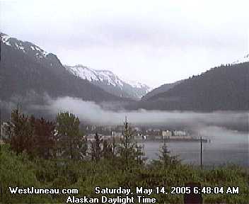