MONTHLY CLIMATOLOGICAL
SUMMARY for AUGUST 2005
CONDITIONS DAY of
Month: 1 2 3 4 5 6 7 8 9 10 11 12 13 14 15 16 17 18 19 20 21 22 23 24 25 26 27 28 29 30 31
NAME: 3270 Nowell CITY: West Juneau STATE: Alaska
ELEV: 97 ft LAT: 58° 17' 33" N LONG: 134° 25' 37" W
TEMPERATURE (°F), RAIN (in), WIND SPEED (mph), SNOW (in). Snowfall from 21:00 - 21:00, all others Midnight to Midnight.
HEAT COOL AVG WIND SNOW
MEAN DEG DEG WIND DOM RUN ON(1)
DAY TEMP HIGH TIME LOW TIME DAYS DAYS RAIN SPEED HIGH TIME DIR (mi) SNOW GRND WEATHER
-----------------------------------------------------------------------------------------------------------------------------------------------------
1 53.5 63.7 2:30p 44.1 5:20a 11.5 0.0 TRACE 0.8 11.0 1:30p S ? 18.06 0.0 0.0 P/MCld MClr Fog MCld Cld Spr Cld/Brks M/PCld Cld
2 57.6 63.4 2:45p 49.9 5:15a 7.4 0.0 0.00 1.4 14.0 10:50a E ? 32.82 0.0 0.0 Cld VryThin-ThinOvcst PCld MCld Cld/TinyBrk VarOvcst
3 54.0 56.5 12:50a 52.3 3:15a 11.0 0.0 0.40 3.4 16.0 6:50p SE 81.91 0.0 0.0 Cld Cld/Rn Cld/Mist-Spr-Rn Cldy Cld-LtMist Cld/Rn
4 54.8 55.6 1:55p 53.3 6:45a 10.2 0.0 0.67 3.2 14.0 12:05a SE 76.61 0.0 0.0 LoCld/Rn Cld/LtRn-Mist-Spr Cld/Rn Cld/LtRn-Spr-Rn
5 55.1 56.9 2:55p 53.3 11:25p 9.9 0.0 0.42 2.2 14.0 1:00a SE 52.31 0.0 0.0 Cld/SomeRn Cld-MtntopsinClds-LwrBands/Rn-LtRn-Spr
6 57.1 65.3 3:20p 51.9 11:55p 7.9 0.0 0.01 0.7 11.0 2:35p WNW 15.59 0.0 0.0 Cld-LoCld/BitRn Cld-Fog VarFog VarCldtoPCld MClear
7 58.8 69.9 4:45p 48.5 5:35a 7.1 0.9 0.00 3.1 17.0 11:25a SW 73.77 0.0 0.0 MCld Cld/Brk Brzy MClr-Pcld Clr Thin/VryThinCld MClr
8 61.1 75.6 5:45p 49.5 5:35a 6.2 2.3 0.00 3.1 16.0 4:45p SW 74.11 0.0 0.0 MostClear PCld/Clr MClr AllDay-Haze&Thin-VryThinClds
9 64.9 83.4 3:50p 50.8 5:15a 4.9 4.8 0.00 1.7 10.0 2:00a SW 40.48 0.0 0.0 MClr Ovcst PCld Clr/PCld MClr/Clr HOT Clr Clr-PCld
10 63.5 76.3 3:40p 50.4 6:20a 4.7 3.2 0.00 0.9 8.0 2:20a SW 20.75 0.0 0.0 Clear/MostlyClear Clear from 0750 on
11 63.5 77.0 3:35p 51.0 4:55a 4.8 3.3 0.00 0.6 6.0 6:15p SW 13.30 0.0 0.0 Clear.
12 64.7 77.9 4:45p 52.9 5:20a 4.1 3.9 0.00 0.8 8.0 8:45a SW 18.55 0.0 0.0 Clear.
13 63.0 73.5 4:25p 54.2 5:40a 4.1 2.2 0.00 0.4 5.0 1:05a NE 9.08 0.0 0.0 Clr Clr/PCld M/PartOvcst BrknOvcst PCld Clr/ThinHaze
14 61.2 69.8 4:45p 53.5 5:45a 4.3 0.6 0.00 1.2 12.0 7:45p NE 29.12 0.0 0.0 Clr-SmokyHaze PCld/Clr-Hz Clr/ThinHz IncrCld-ThinHz
15 58.1 60.9 11:10a 55.6 12:00m 6.9 0.0 TRACE 0.4 7.0 12:20a E 10.30 0.0 0.0 IncrCld Cld-MtnTopsinClds LtMisting FewTinyBrk Cldy
16 60.2 67.3 2:25p 53.9 11:15p 5.1 0.3 0.00 2.0 13.0 11:30a W 47.76 0.0 0.0 Cld Fog-CldsAroundMtntops P/MCld Cld/Brk DecrCld Clr
17 58.9 65.6 3:20p 54.8 12:05a 6.1 0.0 0.01 0.6 10.0 12:30p W 14.48 0.0 0.0 CloudedIn Cloudy Cld/VeryLightRn-Mist-Driz
18 57.3 59.5 6:15p 55.4 7:25a 7.7 0.0 0.76 3.7 18.0 3:15a SE 89.40 0.0 0.0 Cld Cld-MtntopinClds/Rain Spr/Mist Cldy-MtntopsinCld
19 56.1 59.9 5:10p 53.6 12:00m 8.9 0.0 0.43 1.3 14.0 2:20p SW 29.97 0.0 0.0 Cld Cld-LwrCld/Rn-LtRn-Driz-Mist Cld PCld Cld Cld/Rn
20 54.0 55.9 2:40p 52.3 10:55p 11.0 0.0 0.30 1.2 13.0 10:30a ESE 28.27 0.0 0.0 Cloudy/PeriodsofLtRn-Spr-Rn-Mist-Driz Cld/HvyRn Cld
21 53.9 56.6 11:45a 51.6 5:30a 11.1 0.0 0.24 2.3 13.0 12:40p SE 55.48 0.0 0.0 AllDay-MtntopinCld Cld Spr Brk LtRnSpr Cld Cld/OccRn
22 53.5 55.3 1:40p 52.3 8:55p 11.5 0.0 0.29 2.4 17.0 5:20a ESE 57.64 0.0 0.0 Cld/Rn cld/Rn-LtRn-Driz-Mist-Spr&OccNoPrecip Cldy
23 54.2 58.4 5:45p 50.7 6:00a 10.8 0.0 TRACE 0.5 10.0 10:45a ENE 12.83 0.0 0.0 Cldy-MtntopsInClds TinyBrks VryLtRn Cldy Brks Cldy
24 54.1 57.0 3:05p 51.3 4:20a 10.9 0.0 0.24 1.9 18.0 11:20p ESE 45.02 0.0 0.0 Cldy Spr-Ltrn-Rn-Driz Cld-PrecipOverMainland Cld/Rn
25 55.3 56.9 11:10a 53.2 10:10p 9.7 0.0 0.79 2.6 17.0 12:45a ESE 62.95 0.0 0.0 Cldy OccRn-LtRn-Driz Cldy-Rain Cld/Rn-LtRn-Driz
26 53.2 57.2 2:20p 49.8 2:45a 11.8 0.0 0.13 1.2 12.0 12:00p ESE 29.59 0.0 0.0 Cld/Rn-LtRn-Driz-Spr Cldy Shwrs Cld-Ovcst/OccPrecip
27 53.0 61.5 5:00p 48.2 4:10a 12.0 0.0 TRACE 1.7 13.0 3:10p SW 41.79 0.0 0.0 Cld/OccSpr BitofFog Ovcst Cld/Spr PCld MCld P/MCldy
28 57.6 70.6 12:05p 47.1 12:00m 8.3 1.0 0.00 2.7 14.0 8:20a WSW 64.73 0.0 0.0 PCld Clear-SomeScatteredClds Clear
29 51.3 53.2 5:00a 46.2 12:45a 13.7 0.0 0.58 1.8 13.0 11:50a SE 44.05 0.0 0.0 Clear Cldy Cld-LwrClds/Rn-LtRn-Mist-Spr-Driz Cld/Rn
30 52.8 53.6 5:00p 51.9 4:45a 12.2 0.0 0.48 2.5 17.0 5:40p SSE 60.22 0.0 0.0 Cld/SomeRn Cld-LwrCld/Spr-Rn Cld/Rn-Spr Cld Cld/Rn
31 51.0 52.0 12:05a 49.5 11:10p 14.0 0.0 0.31 1.9 13.0 10:35a SSE 44.75 0.0 0.0 Cld/OccMist-Spr MtntopinCld/LtRn-Rn Cld/LtRn-Rn-Driz
-----------------------------------------------------------------------------------------------------------------------------------------------------
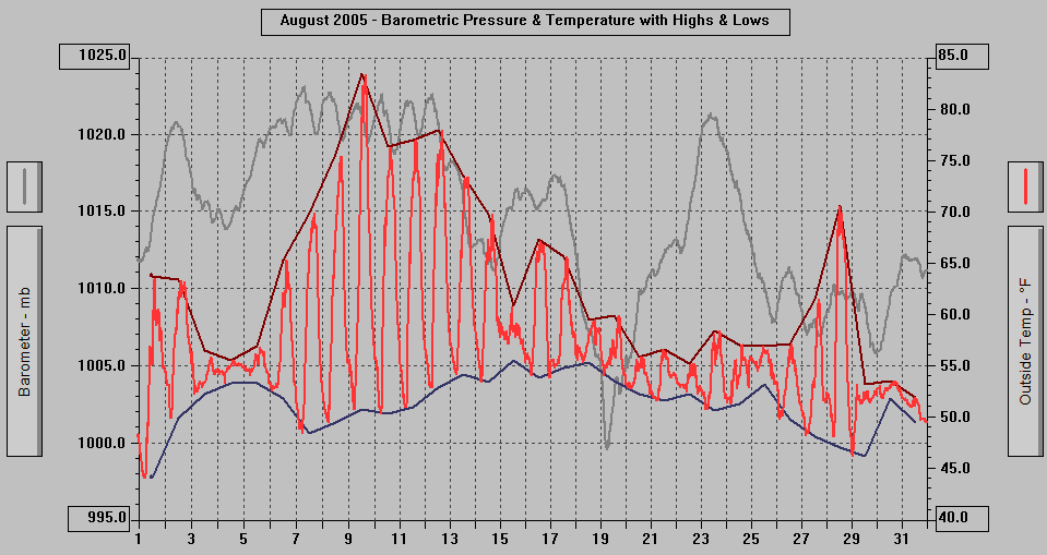
57.0 83.4 9 44.1 1 269.8 22.5 6.06 1.7 18.0 18 SE 1295.69
Wind Direction Vane recalibrated August 3, 2005, it had drifted up to 45 degrees since
July 18, 2005 (SE would show as E)....so wind direction data from July 19, 2005 -
August 2, 2005 is probably unreliable.
(1) As measured on Front Lawn
STATISTICS | DATA | GRAPHS | CONDITIONS - DAY of MONTH: 1 2 3 4 5 6 7 8 9 10 11 12 13 14 15
16 17 18 19 20 21 22 23 24 25 26 27 28 29 30 31| TOP
AVERAGE Mean Temp: 57.0
AVERAGE High Temp: 63.4
MINIMUM High Temp: 52.0 31st
MAXIMUM High Temp: 83.4 9th
AVERAGE Low Temp: 51.4
MINIMUM Low Temp: 44.1 1st
MAXIMUM Low Temp: 55.6 15th
MAX >= 90.0: 0
MAX >= 80.0: 1 9th
MAX >= 70.0: 7 8th, 9th, 10th, 11th, 12th, 13th, 28th
MAX <= 32.0: 0
MIN <= 32.0: 0
MIN <= 0.0: 0
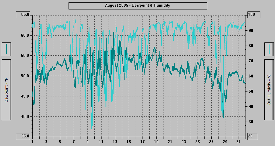
MAXIMUM Humidity (%): 97 7th @ 0635
MINIMUM Humidity (%): 24 9th @ 1512
MAXIMUM Pressure (mb): 1023.1 7th @ 0729
MINIMUM Pressure (mb): 999.6 19th @ 0614
TOTAL Htg Deg Days: 269.8
AVERAGE Htg Deg Days: 8.7
MINIMUM Htg Deg Days: 4.1 12th, 13th
MAXIMUM Htg Deg Days: 14.0 31st
TOTAL Cool Deg Days: 22.5
Heat Base: 65.0 Cool Base: 65.0 Method: Integration
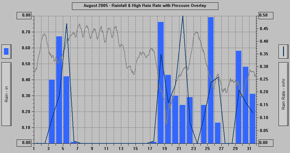
TOTAL Precip.: 6.06
AVERAGE Precip.: 0.3
DAYS of Precip.: 20
MAXIMUM Precip.: 0.79 25th
MAXIMUM Rain Rate: 0.50 21st @ 1642
Days of Rain: 14 (>.01 in) 14 (>.1 in) 0 (>1 in)
TOTAL Snowfall: 0.0
DAYS of Snowfall: 0
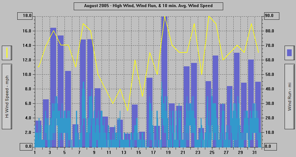
AVERAGE High Wind: 12.7
MINIMUM High Wind: 5 13th
MAXIMUM High Wind: 18 24th
WIND RUN (miles): 1295.69
DAYS OF Sun: 16 1st, 2nd, 6th-14th, 19th, 23rd, 27th, 28th
DAYS OF Totally Clear: 2 11th, 12th
DAYS OF Cld or M Cld: 26 All but: 8th, 10th-12th, 28th
DAYS OF Rainbow: 0
DAYS OF Aurora: 0
DAYS OF Lightning: 0
DAYS OF Earthquake: 0
- 2050 ADT: Misting/Very Light Drizzle, Cloudy
with the very tops of the mountains in the
clouds and a few lower wisps.
- 1950: Rain, Cloudy with a few lower wisps
and bits of fog/clouds.
- 1850: Sprinkling/Very Light Rain, Cloudy
with the very top of Mt. Juneau and Mt. Roberts
in the clouds, a few lower wisps and ribbons.
- 1750: Light Rain/Drizzle, Cloudy with some
lower fog/clouds.
- 1735: Light Drizzle, Cloudy with some lower
fog/clouds.
- 1650: Rain, Cloudy with the top of Mt. Roberts
in the clouds, Mt. Juneau hidden by fog/clouds
and the inner Gold Creek valley hidden, the
mainland otherwise is partially obscured.
- 1635: Very Light Misting/Sprinkling, Cloudy
with the very tops of the mountains in the
clouds and lower fog/clouds.
- 1550: Cloudy with precipitation over the
mainland mountains and valleys, a few lower
wisps and bits of fog/clouds.
- 1520: Extremely Light Sprinkling (hardly
detectable), Cloudy with some lower bits
and wisps of fog/clouds.
- 1505: The Weekly Picture - new one just posted.
- 1450: Rain, Cloudy with some lower fog/clouds.
- 1447: A Robin on the deck's seatback top
briefly.
- 1350: Rain, Cloudy with some lower fog/clouds.
- 1335: Light Rain, Cloudy with some lower
bits and wisps of fog/clouds.
- 1250: Rain, Cloudy with lower bits and wisps
of fog/clouds.
- 1235: Rain, Cloudy with a few lower wisps,
clouds skimming Mt. Roberts.
- 1205: Light Rain, Cloudy with the clouds
skimming the top of Mt. Roberts and Mt. Juneau.
- 1150: Sprinkling, Cloudy with clouds skimming
Mt. Juneau and the Mt. Juneau Ridge, very
top of Mt. Roberts in the clouds.
- 1120: Rain, Cloudy with clouds skimming Mt
Juneau, very top of Mt. Roberts in the clouds.
- 1050: Sprinkling, Cloudy with clouds skimming
Mt. Juneau, top of Mt. Juneau Ridge and Mt.
Roberts in the clouds.
- 1005: Rain, Cloudy with the mountaintops
in the clouds.
- 0950: Light Sprinkling/Misting, Cloudy with
the mountaintops in the clouds.
- 0850: Cloudy with the mountaintops in the
clouds, precipitation in the inner Gold Creek
valley.
- 0820: Light Rain, Cloudy with the mountaintops
in the clouds.
- 0750: Cloudy with the mountaintops in the
clouds.
- 0720: Misting/Sprinkling, Cloudy with the
mountaintops in the clouds.
- 0650: Occasional Misting/Sprinkling, Cloudy
with the mountaintops in the clouds.
- 0620 ADT: Cloudy with the mountaintops in
the clouds.
- 2050 ADT: Cloudy with the mountaintops in
the clouds.
- 1920: Rain, Cloudy with the mountaintops
in the clouds.
- 1850: Light Sprinkling, Cloudy with the mountaintops
in the clouds.
- 1820: Cloudy with the mountaintops in the
clouds, some sprinkles/very light rain in
the past 1/2 hour.
- 1750: Cloudy with the mountaintops in the
clouds.
- 1720: Cloudy with the mountaintops in the
clouds.
- 1650: Sprinkling/Very Light Rain, Cloudy
with the mountaintops in the clouds.
- 1550: Light Rain, Cloudy with the mountaintops
in the clouds.
- 1505: Rain, Cloudy with the mountaintops
in the clouds.
- 1450: Light Rain, Cloudy with the mountaintops
in the clouds.
- 1350: Rain, Cloudy with the mountaintops
in the clouds.
- 1250: Rain, Cloudy with the mountaintops
in the clouds.
- 1150: Rain, Cloudy with the mountaintops
in the clouds.
- 1050: Rain, Cloudy with the mountaintops
in the clouds.
- 1020: Sprinkling, Cloudy with the mountaintops
in the clouds.
- 0950: Rain, Cloudy with the mountaintops
in the clouds and a few lower wisps.
- 0935: Extremely Light Misting/Sprinkling,
Cloudy with the mountaintops in the clouds,
some lower fog/clouds in Last Chance Basin,
a few lower wisps.
- 0850: Rain, Cloudy with some fog/clouds around
the top of Mt. Roberts, lower band of fog/clouds
hiding much of Last Chance Basin and Mt.
Juneau.
- 0835: Rain, Cloudy with some fog/clouds around
the top of Mt. Roberts, lower band of fog/clouds
hiding much of Last Chance Basin and Mt.
Juneau.
- 0750: Sprinkling, Cloudy with some fog/clouds
around the top of Mt. Roberts, lower fog/clouds
hiding some of Last Chance Basin and the
upper parts of Mt. Juneau.
- 0650: Extremely Light Sprinkling (hardly
detectable), Cloudy with the mountaintops
mostly hidden and lower band and bits of
fog/clouds.
- 0620 ADT: Cloudy with fog/clouds hiding much
of the top of Mt. Roberts and all of Last
Chance Basin and most of Mt. Juneau.
- 2050 ADT: Misting, Cloudy with the mountaintops
in the clouds.
- 2035: Cloudy with the mountaintops in the
clouds.
- 1950: Light Rain/Drizzle, Cloudy with the
mountaintops in the clouds.
- 1935: Rain, Cloudy with the mountaintops
in the clouds, mainland partially obscured,
yellowish-brownish glow.
- 1920: Very Light Rain/Drizzle, Cloudy with
the mountaintops in the clouds.
- 1850: Rain, Cloudy with the mountaintops
in the clouds.
- 1835: Rain, Cloudy with the mountaintops
in the clouds.
- 1750: Rain, Cloudy with the mountaintops
in the clouds, a few lower wisps and bits
of fog/clouds, mainland partially obscured.
- 1650: Rain, Cloudy with the mountaintops
in the clouds, mainland partially obscured,
inner Gold Creek valley totally obscured.
- 1550: Rain, Cloudy with the mountaintops
in the clouds, mainland slightly obscured.
- 1450: Rain, Cloudy with the mountaintops
in the clouds and mainland partially obscured,
inner Gold Creek valley totally obscured.
- 1435: Misting, Cloudy with the mountaintops
in the clouds and a few lower wisps.
- 1350: Rain-Drizzle, Cloudy with the mountaintops
in the clouds and mainland partially obscured,
inner Gold Creek valley totally obscured.
- 1250: Light Rain/Drizzle, Cloudy with the
mountaintops in the clouds and lower wisps.
- 1220: Light Rain/Drizzle, Cloudy with the
mountaintops in the clouds and lower wisps,
mainland slightly obscured.
- 1207: A Steller's Jay is taking a bath in
the Bird Bath.
- 1150: Misting/Sprinkling, Cloudy with the
mountaintops in the clouds and some lower
bits and wisps of fog/clouds.
- 1050: Sprinkling/Very Light Rain, Cloudy
with the mountaintops in the clouds, lower
band of fog/clouds in Last Chance Basin and
on the Channel side of Mt. Juneau.
- 1035: Very Light Rain, Cloudy with lower
fog/clouds hiding the top of Mt. Roberts,
in Last Chance Basin, and hiding much of
Mt. Juneau.
- 0950: Sprinkling, Cloudy with some fog/clouds
around the top of Mt. Roberts and lower ribbon
and wisps of fog/clouds.
- 0935: Rain, Cloudy with some fog/clouds around
the top of Mt. Juneau and lower ribbons and
wisps.
- 0850: Rain, Cloudy with a few wisps around
the mountains.
- 0750: Rain, Cloudy with a bit of fog/clouds
around the very top of Mt. Juneau and the
Mt. Juneau Ridge.
- 0735: Rain, Cloudy with clouds skimming the
Mt. Juneau Ridge.
- 0720: Very Light Rain, Cloudy.
- 0650: Light Sprinkling, Cloudy - Overcast.
- 0620 ADT: Cloudy, Overcast.
SUNDAY 8/28/05: DATA
- 2050 ADT: Clear.
- 1950: Clear.
- 1850: Clear with a few tiny clouds far to
the NW.
- 1826: The sun set behind the Douglas Island
mountains.
- 1805: Clear with 2 small clouds.
- 1650: Clear with a few small clouds.
- 1605: Clear with some scattered clouds.
- 1450: Clear with a few scattered small clouds.
- 1350: Clear/Partly Cloudy.
- 1250: Clear with some scattered clouds.
- 1150: Mostly Clear with some scattered clouds.
- 1050: Clear/Partly Cloudy with scattered
clouds.
- 0950: Mostly Clear (scattered clouds).
- 0850: Mostly Clear (some scattered clouds).
- 0750: Mostly Clear (some scattered clouds).
- 0733: The sun started rising to the left
of Gastineau Peak on Mt. Roberts.
- 0650: Clear with some scattered clouds.
- 0620 ADT: Clear with a few scattered clouds.
- 2050 ADT: Partly/Mostly Cloudy.
- 1950: Partly Cloudy.
- 1935: Partly Cloudy/Clear SE 2/3rds of sky,
mostly thin overcast NW 1/3rd, sun shining
on parts of the mainland mountains.
- 1850: Mostly Cloudy, sun shining on parts
of the mainland.
- 1750: Partly Cloudy/Clear SE 2/3rds of sky,
mostly thin overcast NW 1/3rd, slightly weakened
sunshine.
- 1650: Partly Cloudy/Clear SE half of sky,
partly/mostly cloudy NW part.
- 1550: Partly Cloudy SE half of sky, Cloudy
with breaks NW half, sun is shining.
- 1523: The sun came out brightly for the first
time today.
- 1520: Partly Cloudy eastern part of the sky,
cloudy NW part and a few small breaks for
the remainder.
- 1450: Cloudy with bright skies and some breaks
and broken areas in the SE part of the sky,
extremely weak sunshine.
- 1405: Cloudy with a break to the SSE, a hint
of blue to the North.
- 1350: Cloudy with a few bright spots and
a thinner area or two, very weak sunshine
on the Mt. Juneau Ridge.
- 1305: Light Sprinkling, Cloudy with bright
spots, extremely weak sunshine in Last Chance
Basin.
- 1250: Sprinkling, Cloudy with a few lower
wisps.
- 1150: Cloudy - Overcast, location of the
sun barely visible, a few lower wisps and
ribbons of fog/clouds.
- 1120: Cloudy - Overcast with a lower ribbon
of fog/clouds.
- 1050: Cloudy - Overcast with the sun visible
through the overcast, lower ribbon and wisps
of fog/clouds.
- 0950: Cloudy - Overcast with lower ribbon-band
and wisps of fog/clouds.
- 0850: Cloudy - Overcast with a lower ribbon
and wisps of fog/clouds and fog/clouds in
Last Chance Basin.
- 0820: Cloudy - Overcast with lower ribbon/band
and wisps of fog/clouds.
- 0750: Cloudy with lower fog/clouds hiding
the mainland above 300' - 400', Blueberry
Hills in fog.
- 0735: Cloudy - Overcast with lower fog hiding
the mainland above 200' - 300', Blueberry
Hills in fog.
- 0650: Very Light Sprinkling, Cloudy - Overcast
with a few lower ribbons and wisps of fog/clouds.
- 0620 ADT: Cloudy - Overcast with lower band
of fog over Gastineau Channel and some thin
fog in the upper parts of West Juneau.
- 2050 ADT: Very Light Rain, Cloudy - Overcast.
- 2005: Cloudy - Overcast with a few lower
wisps.
- 1950: Sprinkling/Very Light Rain, Cloudy
- Overcast, a few wisps in Last Chance Basin.
- 1905: Sprinkling, Cloudy.
- 1850: Cloudy.
- 1750: Cloudy with a few thinner areas and
a few hints of blue, small bit of fog/clouds
around the Mt. Juneau Ridge.
- 1650: Cloudy with an occasional sprinkle,
a few wisps around the mountaintops.
- 1550: Cloudy with part of the top of Mt.
Roberts in the clouds.
- 1520: Extremely Light Sprinkling, Cloudy
with part of the top of Mt. Roberts in the
clouds.
- 1505: Rain Shower, Cloudy with clouds skimming
Mt. Roberts.
- 1450: Cloudy with a bit of fog/clouds around
part of the top of Mt. Roberts.
- 1435: Cloudy with bright spots and a bit
of fog/clouds skimming the mountaintops.
- 1420: Rain Shower, Cloudy with clouds skimming
the top of Mt. Roberts.
- 1350: Very Light Sprinkling, Cloudy with
much of the very tops of the mountains in
the clouds.
- 1320: Very Light Sprinkling, Cloudy with
a bit of fog/clouds around the mountaintops,
a small break to the North.
- 1250: Cloudy with breaks, a bit of fog/clouds
around the top of Mt. Juneau and Mt. Roberts.
- 1220: Cloudy with bright spots, some fog/clouds
around the mountaintops.
- 1150: Cloudy with a few very tiny breaks,
cloudy with fog/clouds around the mountaintops.
- 1050: Cloudy with the very tops of the mountains
in the clouds, some small and tiny breaks,
a few lower wisps and bits of fog/clouds.
- 0950: Cloudy with the mountaintops in the
clouds.
- 0920: Cloudy with the mountaintops in the
clouds a few lower wisps of fog/clouds.
- 0850: Light Misting/Sprinkling, Cloudy with
fog/clouds around the mountaintops, some
lower bits and wisps of fog/clouds.
- 0823: Light Rain, Cloudy with the mountaintops
in the clouds and a few lower bits and wisps
of fog/clouds.
- 0805: Cloudy with bright areas, mountaintops
in the clouds, lower fog/clouds hiding most
of Mt. Roberts and some of Last Chance Basin
and Mt. Juneau.
- 0750: Extremely Light Misting/Sprinkling
(hardly detectable), Cloudy with the mountaintops
in the clouds, lower band/ribbon of fog/clouds.
- 0735: Sprinkling/Very Light Rain, Cloudy
with the mountaintops in the clouds and lower
band, bits, and wisps of fog/clouds.
- 0650: Rain, Cloudy with the mountaintops
in the clouds and variable lower fog/clouds
hiding parts of the mainland.
- 0620 ADT: Light Rain/Drizzle, Cloudy with
clouds hiding the mainland mountains above
1000'.
- 2050 ADT: Very Light Rain/Drizzle, Cloudy
with the mountaintops in the clouds and a
lower band in Last Chance Basin and on the
Channel side of Mt. Juneau.
- 2005: Extremely Light Misting/Sprinkling,
Cloudy with lower fog/clouds hiding the mainland
above about 300'.
- 1950: Light Rain, Cloudy with fog/clouds
around the mountaintops, lower band and wisps
of fog/clouds.
- 1850: Rain, Cloudy with fog/clouds around
the mountaintops and lower ribbon and band
of fog/clouds.
- 1750: Rain, Cloudy with a bit of fog/clouds
around the top of Mt. Juneau and Mt. Roberts,
Mt. Juneau Ridge in the clouds, lower band
and ribbon of fog/clouds.
- 1735: Rain, Cloudy with a bit of fog/clouds
around the top of Mt. Juneau and Mt. Roberts,
lower band and ribbon of fog/clouds. Gastineau
Channel at the mouth of Gold Creek is muddy.
- 1650: Rain, Cloudy with the top of Mt. Juneau
in the clouds, fog/clouds around the top
of Mt. Roberts, and a lower band hiding much
of Last Chance Basin and part of Mt. Roberts
and Mt. Juneau.
- 1550: Rain, Cloudy with the mountaintops
in the clouds and lower band, wisps, and
bits of fog/clouds.
- 1520: Rain, Cloudy with the mountaintops
in the clouds and some lower wisps.
- 1450: Rain, Cloudy with the mountaintops
in the clouds.
- 1350: Rain, Cloudy with the mountaintops
in the clouds and a few lower wisps, inner
Gold Creek valley mostly hidden.
- 1250: Rain, Cloudy with the mountaintops
in the clouds and a few lower wisps.
- 1150: Rain, Cloudy with the mountaintops
in the clouds, ceiling at around 2400', inner
Gold Creek valley mostly obscured.
- 1050: Rain, Cloudy with the mountaintops
in the clouds - ceiling at around 2400'.
- 1020: Rain, Cloudy with the mountaintops
in the clouds.
- 0950: Cloudy with the mountaintops in the
clouds.
- 0850: Cloudy with the mountaintops in the
clouds.
- 0820: Cloudy with the mountaintops in the
clouds.
- 0750: Cloudy with the mountaintops in the
clouds, precipitation over parts of the mainland.
- 0720: Light Rain/Drizzle, Cloudy with the
mountaintops in the clouds, mainland partially
obscured.
- 0650: Extremely Light Misting/Sprinkling,
Cloudy with the mountaintops in the clouds.
- 0629: Webcam Picture
- 0620 ADT: Cloudy with the mountaintops in
the clouds, precipitation over the mainland
mountains and valleys.
8/24/05: DATA | First day of school - Public and Private
| The Weekly Picture - new one just posted.
- 2050 ADT: Rain, Cloudy with the very tops
of the mountains in the clouds.
- 2042: Webcam Picture
- 1950: Rain, Cloudy.
- 1850: Rain, Cloudy.
- 1750: Light Sprinkling, Cloudy.
- 1735: Sprinkling, Cloudy.
- 1720: Very Light Rain, Cloudy.
- 1650: Cloudy, some light precipitation over
parts of the mainland?
- 1550: Cloudy, some light precipitation over
parts of the mainland.
- 1450: Cloudy, some light precipitation over
parts of the mainland?
- 1350: Cloudy, some light precipitation over
parts of the mainland.
- 1345: A Great Blue Heron flew WNW over the
backyard.
- 1320: Cloudy, precipitation over parts of
the mainland.
- 1250: Light Sprinkling, Cloudy.
- 1205: Rain, Cloudy.
- 1150: Light Rain, Cloudy.
- 1120: Cloudy, some precipitation over parts
of the mainland.
- 1050: Cloudy with clouds skimming Mt. Juneau
and Mt. Roberts, some precipitation over
parts of the mainland, fog/cloud on the Channel
side of Mt. Juneau.
- 0950: Rain/Drizzle, Cloudy with the mountaintops
obscured and the remainder of the mainland
partially obscured (inner Gold Creek valley
totally obscured).
- 0920: Sprinkling/Very Light Rain, Cloudy
with the very tops of the mountains in the
clouds, inner Gold Creek valley mostly obscured.
- 0850: Cloudy with some clouds around the
very top of Mt. Roberts, precipitation in
the inner Gold creek valley, Last Chance
Basin, and part of Mt. Juneau.
- 0820: Sprinkling/Very Light Rain, Cloudy
with the very top of Mt. Juneau and Mt. Roberts
in the clouds.
- 0750: Cloudy with the very tops of the mountains
in the clouds, light to almost breezy wind.
- 0720: Extremely Light Misting/Sprinkling,
Cloudy with the very tops of the mountains
in the clouds.
- 0650: Cloudy with thinner overcast in areas,
clouds skimming Mt. Juneau and the Mt. Juneau
Ridge, top of Mt. Roberts in the clouds.
- 0632: The Weekly Picture - new one just posted.
- 0620 ADT: Cloudy with the very tops of the
mountains in the clouds, some light precipitation
over parts of the mainland.
- 2050 ADT: Cloudy.
- 1950: Cloudy with some breaks, clouds skimming
the Mt. Juneau Ridge, some of the clouds
highlighted by the sun, some very light precipitation
over parts of the mainland during the past
hour.
- 1850: Cloudy with some small breaks.
- 1750: Cloudy with breaks in the NW half of
the sky, clouds skimming Mt. Juneau and the
Mt. Juneau Ridge, sun has been shining here
and is currently shining on downtown and
the cruise ships.
- 1650: Cloudy with a few spots where blue
is visible, clouds skimming the top of Mt.
Juneau, Mt. Juneau Ridge in the clouds, weak
sun on part of the top of Mt. Juneau.
- 1635: Cloudy with breaks, clouds skimming
Mt. Juneau and Mt. Roberts, Mt. Juneau Ridge
in the clouds, a few wisps in Last Chance
Basin, weakened sun has been shining on parts
of the mainland.
- 1550: Cloudy with clouds skimming Mt. Roberts,
very top of Mt. Juneau in the clouds, Mt.
Juneau Ridge in the clouds, a few wisps and
bits of fog/clouds in Last Chance Basin.
- 1450: Cloudy with fog/clouds around the mountaintops,
lower ribbon on the Channel side of Mt. Roberts,
some fog/clouds in Last Chance basin.
- 1350: Cloudy with the mountaintops in the
clouds, ceiling at about 2500', fog/cloud
in Last Chance Basin.
- 1320: Very Light Rain, Cloudy with the mountaintops
in the clouds, inner Gold Creek valley filled
with clouds.
- 1305: Extremely Light Sprinkling, Cloudy
with fog/clouds around the mountaintops,
lower clouds in the inner Gold Creek valley.
- 1250: Cloudy with the mountaintops in the
clouds and a lower cloud in Last Chance Basin.
- 1150: Cloudy with the mountaintops in the
clouds.
- 1135: Cloudy with the mountaintops in the
clouds, ceiling at about 1800'.
- 0945: Cloudy with hints of breaks and tiny
breaks, mountaintops in the clouds, ceiling
1600' or so, bright spots, a few wisps in
Last Chance Basin.
- 0920: Cloudy with a tiny break in the NW
part of the sky, mountaintops in the clouds
- ceiling at about 1500', a few wisps and
bits of fog/clouds in Last Chance Basin and
on the Channel side of Mt. Juneau.
- 0850: Cloudy with the mountaintops in the
clouds and a lower ribbon and bits of fog/clouds.
- 0750: Cloudy with the mountaintops in the
clouds and a lower ribbon and wisps of fog/clouds.
- 0720: Cloudy with a few hints of blue overhead,
mountaintops in the clouds, some fog/clouds
in Last Chance Basin.
- 0635: Cloudy with thinner areas where blue
is visible, mountaintops in the clouds and
some fog/clouds in Last Chance Basin.
- 0620 ADT: Cloudy with the mountaintops in
the clouds, a few hints of blue, some fog/clouds
in Last Chance Basin.
- 2050 ADT: Cloudy with the mountaintops in
the clouds and a few lower wisps and bits
of fog/clouds, a few hints of breaks to the
NW.
- 2005: Cloudy with the mountaintops in the
clouds and a few lower wisps.
- 1850: Cloudy with a few hints of blue overhead,
mountaintops in the clouds - ceiling 2400'
- 2500', a few lower wisps.
- 1750: Cloudy with a lower ribbon of fog/clouds.
- 1650: Cloudy with the mountaintops in the
clouds, lower ribbon/band of fog/clouds.
- 1620: Extremely Light Misting, Cloudy with
the mountaintops in the clouds and a lower
band of fog/clouds.
- 1605: Light Rain/Drizzle, Cloudy with the
mountaintops in the clouds and lower wisps
and bits of fog/clouds.
- 1550: Extremely Light Misting, Cloudy with
the mountaintops in the clouds and lower
ribbon and wisps, SW part of the sky bright.
- 1450: Light Sprinkling/Misting, Cloudy with
the mountaintops in the clouds, lower ribbon
and wisps of fog/clouds.
- 1435: Misting, Cloudy with the mountaintops
in the clouds, a few lower wisps and bits
of fog/clouds.
- 1350: Cloudy with the mountaintops in the
clouds, a few lower wisps and bits of fog/clouds.
- 1320: Extremely Light Sprinkling/Misting,
Cloudy with the mountaintops in the clouds
and lower bits, ribbons, and wisps of fog/clouds.
- 1250: Rain, Cloudy with the mountaintops
in the clouds and a few lower wisps.
- 1150: Very Light Sprinkling/Misting, Cloudy
with the mountaintops in the clouds and a
few lower wisps.
- 1120: Extremely Light Sprinkling - hardly
detectable, cloudy with the mountaintops
in the clouds - ceiling at around 2400',
a few lower wisps and bits of fog/clouds.
- 1105: Light Rain, Cloudy with the mountaintops
in the clouds - ceiling at around 2500'.
- 0950: Rain, Cloudy with the mountaintops
in the clouds, ceiling 2000' - 2200'.
- 0935: Rain, Cloudy with the mountaintops
in the clouds, ceiling 2000' - 2200'.
- 0850: Cloudy with the mountaintops in the
clouds.
- 0750: Rain, Cloudy with the mountaintops
in the clouds - ceiling at about 1500', a
few lower wisps in Last Chance Basin.
- 0720: Light Rain/Drizzle, Cloudy with the
mountaintops in the clouds - ceiling at about
1700' - 1800'.
- 0650: Cloudy with the mountaintops in the
clouds - ceiling at about 1700'.
- 0648: A Townsend's Warbler is in the willow
by the deck.
- 0635: Cloudy with the mountaintops in the
clouds - ceiling at about 1700'.
- 0620 ADT: Rain, Cloudy with the mountaintops
in the clouds - ceiling at about 1700'.
SUNDAY 8/21/05: DATA
- 2050 ADT: Cloudy with the mountaintops in
clouds, inner Gold Creek valley filled with
clouds and a few other bits and wisps of
fog/clouds.
- 1950: Cloudy with the mountaintops in the
clouds, fog/clouds in Last Chance Basin.
- 1920: Rain, Cloudy with the mountaintops
in the clouds and some lower bits and wisps
of fog/clouds.
- 1850: Cloudy with the mountaintops in the
clouds, lower fog/clouds in Last Chance Basin
and on the Channel side of Mt. Juneau.
- 1750: Very Light Drizzle/Misting, Cloudy
with the mountaintops in the clouds and some
lower fog/clouds - Last Chance Basin filled
with clouds.
- 1720: Light Rain/Drizzle, Cloudy with the
mountaintops in the clouds, some fog/clouds
in Last Chance Basin.
- 1650: Rain, Cloudy with the mountaintops
in the clouds, some lower fog/clouds in Last
Chance Basin.
- 1620: Rain, Cloudy with the mountaintops
in the clouds.
- 1550: Cloudy with the mountaintops in the
clouds.
- 1450: Cloudy with a few very tiny breaks
in the SE part of the sky, mountaintops in
the clouds, very weak sun on part of Mt.
Roberts. 2 or 3 Great Blue Herons are flying
around.
- 1420: Sprinkling, Cloudy with a broken area
overhead, mountaintops in the clouds, some
lower wisps on the Channel side of Mt. Juneau.
- 1350: Very Light Misting, Cloudy with the
mountaintops in the clouds.
- 1250: Extremely Light Misting, Cloudy with
a very tiny break overhead, mountaintops
in the clouds with some lower fog/clouds
in Last Chance Basin and on the Channel side
of Mt. Juneau.
- 1205: Light Rain, Cloudy with the mountaintops
in the clouds and a few lower wisps.
- 1150: Cloudy with some very tiny breaks,
mountaintops in the clouds and a few lower
wisps.
- 1050: Cloudy with a tiny break to the ESE,
mountaintops in the clouds, lower bits and
ribbons of fog/clouds in Last Chance Basin
and on the Channel side of Mt. Juneau.
- 0950: Cloudy with a few breaks in the NW
part of the sky, some bright spots, mountaintops
in the clouds, lower ribbon and wisps of
fog/clouds.
- 0850: Extremely Light Sprinkles, Cloudy with
the mountaintops in the clouds and a lower
ribbon and wisps.
- 0750: Very Light Sprinkles, Cloudy with the
mountaintops in the clouds, lower wisps,
ribbons, and bits of fog/clouds.
- 0720: Sprinkling, Cloudy with the mountaintops
in the clouds, lower wisps of fog/clouds.
- 0650: Cloudy with the mountaintops in the
clouds, lower ribbon and wisps of fog/clouds.
- 0620 ADT: Cloudy with the mountaintops in
the clouds, no rain registered after midnight.
- 2050 ADT: Rain, Cloudy with the very tops
of the mountains in the clouds, a few lower
bits and wisps of fog/clouds.
- 2005: Rain, Cloudy with the mountaintops
in the clouds.
- 1935: Cloudy with the very tops of the mountains
in the clouds, some bright spots and tiny
breaks to the NW.
- 1850: Very Light Misting, Cloudy with the
mountaintops in the clouds.
- 1750: Light Rain, Cloudy with the clouds
skimming Mt. Roberts and the Mt. Juneau Ridge,
very top of Mt. Juneau in the clouds.
- 1650: Light Rain, Cloudy with some lower
bits and wisps of fog/clouds.
- 1550: Cloudy with the very tops of the mountains
in the clouds.
- 1520: Cloudy, some precipitation in the inner
Gold Creek valley and over part of Mt. Roberts.
- 1450: Cloudy with the very tops of the mountains
in the clouds, some wisps over the Channel
slope of Mt. Juneau.
- 1350: Extremely Light Misting/Sprinkling,
Cloudy with the mountaintops mostly in the
clouds, a few lower wisps and bits of fog/clouds.
- 1250: Light Rain/Drizzle, Cloudy with the
mountaintops mostly in the clouds, and some
lower wisps.
- 1152: 8 young Robins on the lawns along Nowell
Avenue.
- 1150: Rain, Cloudy with the top of Mt. Juneau,
very top of Mt. Juneau Ridge in the clouds
and much of the top of Mt. Roberts in the
clouds.
- 1135: Rain, Cloudy with fog/clouds around
the mountaintops.
- 1050: Cloudy with the mountaintops in the
clouds, a few lower bits and wisps of fog/clouds.
- 0950: Cloudy with a few hints of breaks,
mountaintops in the clouds, some lower fog/clouds
in Last Chance Basin and on the Channel side
of Mt. Juneau.
- 0920: Cloudy with the mountaintops in the
clouds and a few lower bits and wisps of
fog/clouds.
- 0850: Very Light Rain/Sprinkling, Cloudy
with the mountaintops in the clouds and a
few lower wisps and ribbons of fog/clouds.
- 0750: Cloudy with the very tops of the mountains
in the clouds and a few lower wisps.
- 0650: Cloudy with the very tops of the mountains
in the clouds.
- 0620 ADT: Cloudy with the very top of Mt.
Juneau and Mt. Roberts in the clouds and
clouds skimming the Mt. Juneau Ridge, .03"
of rain since midnight.
8/19/05: DATA | For the 4th night in a row uploads have
failed (I'm not unaware of that), the problem
is how to economically rectify that.
- 2050 ADT: Rain, Cloudy - Overcast.
- 2035: Light Rain, Cloudy.
- 2020: Very Light Sprinkling, Cloudy.
- 1950: Cloudy - Overcast with some partly
cloudy sky far to the NW.
- 1920: Cloudy with some breaks to the NW.
- 1850: Mostly Cloudy with mostly thin clouds,
thicker clouds to the SE, sun shining on
the top of Mt. Roberts.
- 1835: Partly/Mostly Cloudy with mostly thin
clouds, sun shining.
- 1750: Partly Cloudy/Clear with more clouds
to the NW.
- 1735: Partly Cloudy, sun in and out.
- 1650: Partly Cloudy SE part of the sky, Mostly
Cloudy NW part, the sun is shining.
- 1635: Mostly Cloudy with spots of sunshine
here and there on the mainland mountains
and a few lower wisps.
- 1550: Cloudy with some breaks, a few wisps
around the mountains.
- 1535: Cloudy with the very tops of the mountains
in the clouds.
- 1450: Light Drizzle/Misting, Cloudy with
the mountaintops in the clouds and the mainland
partially obscured.
- 1435: Light Rain/Drizzle, Cloudy with the
mountaintops in the clouds and the mainland
partially obscured.
- 1350: Very Light Misting/Sprinkling, Cloudy
with the mountaintops in the clouds and a
few lower wisps.
- 1320: Cloudy with the upper parts of the
mountains in the clouds, some lower bits
and wisps of fog/clouds.
- 1250: Very Light Rain/Sprinkling, Cloudy
with the mountaintops in the clouds and some
lower bands, wisps and bits of fog/clouds.
- 1220: Rain, Cloudy with the top of Mt. Roberts
in the clouds with the remainder partially
obscured, lower fog/clouds hiding Last Chance
Basin and Mt. Juneau.
- 1150: Very Light Rain/Sprinkling, Cloudy
with lower fog/clouds hiding most of the
mainland above 200' - 400'.
- 1120: Rain, Cloudy with the top of Mt. Roberts
in the clouds with lower wisps mists and
ribbons, lower fog/clouds hiding Last Chance
Basin and Mt. Juneau.
- 1050: Very Light Misting/Sprinkling, Cloudy
with the top of Mt. Roberts in the clouds
with lower wisps mists and ribbons, lower
fog/clouds hiding Last Chance Basin and Mt.
Juneau.
- 0950: Light Misting, Foggy-Cloudy with mainland
hidden above 150', much of Pioneer Avenue
and Blueberry Hills in fog..
- 0850: Light Rain/Drizzle, Cloudy with some
fog/clouds around the mountaintops and lower
band and mists.
- 0820: Light Rain, Cloudy with the upper parts
of the mountains in the clouds, lower band
and bits and wisps of fog/clouds.
- 0750: Rain, Cloudy with lower fog/clouds
hiding most of the mainland above 150' -
200'.
- 0650: Rain, Cloudy with the tops and very
tops of the mountains in the clouds and a
lower band.
- 0620 ADT: Rain, Cloudy with lower bands,
ribbons, and wisps of fog/clouds.
- 2050 ADT: Cloudy with the mountaintops in
the clouds.
- 2020: Cloudy with lower fog/clouds hiding
much of Mt. Juneau and Mt. Roberts above
700', some wisps and bits of fog/clouds in
Last Chance Basin.
- 1950: Cloudy with the mainland mostly hidden
by fog/clouds above the 700' - 800' elevation,
lower fog/clouds in Last Chance Basin.
- 1850: Cloudy with the mountaintops and upper
parts of the mountains in the clouds, a few
lower wisps.
- 1750: Cloudy with the mountaintops in the
clouds - ceiling at about 1500', precipitation
in the inner Gold Creek valley, a few lower
wisps.
- 1650: Cloudy with the mountaintops in the
clouds, precipitation in the inner Gold Creek
valley.
- 1635: Cloudy with the mountaintops in the
clouds, a few lower wisps.
- 1620: Extremely Light Misting, Cloudy with
the mountaintops in the clouds and a few
lower wisps, ceiling at about 1500'.
- 1550: Light Misting/Sprinkling, Cloudy with
the mountaintops in the clouds, lower ribbon,
bits, and wisps of fog/clouds.
- 1520: Sprinkling/Misting, Cloudy with the
mountaintops in the clouds, lower ribbon
and wisps of fog/clouds.
- 1450: Rain, Cloudy with mountaintops in the
clouds and lower band and wisps of fog/clouds.
- 1350: Light Rain/Drizzle, Cloudy with the
mountaintops in the clouds and some lower
wisps and bits of fog/clouds.
- 1250: Light Rain/Drizzle, Cloudy with the
mountaintops in the clouds and a few lower
wisps.
- 1220: Rain, Cloudy with the mountaintops
in the clouds.
- 1150: Extremely Light Misting, Cloudy with
the mountaintops in the clouds and the mainland
partially obscured and inner Gold Creek valley
hidden.
- 1050: Rain, Cloudy with the mountaintops
in the clouds and the mainland partially
to substantially obscured.
- 0950: Rain-Drizzle, Cloudy with the mountaintops
in the clouds, inner Gold Creek valley substantially
obscured (and has been for most of the morning).
A White Crowned Sparrow - (1st winter bird)
on the deck.
- 0925: A young Robin is on the deck's seat
bench.
- 0850: Rain-Drizzle, Cloudy with the mountaintops
in the clouds and the mainland partially
to slightly obscured.
- 0820: Rain, Cloudy with the mountaintops
in the clouds and the mainland partially
to slightly obscured.
- 0750: Light Drizzle/Misting, Cloudy with
the mountaintops in the clouds and a few
lower bits and wisps of fog/clouds.
- 0650: Rain, Cloudy with the mountaintops
in the clouds and the mainland partially
obscured.
- 0620 ADT: Rain, Cloudy with the mountaintops
in the clouds and the mainland slightly obscured,
light to almost breezy wind, .42" of
rain so far today.
- 2135 ADT: There has been some sprinkles/light
rain.
- 2050: Cloudy.
- 1950: Cloudy.
- 1850: Cloudy.
- 1750: Cloudy.
- 1650: Cloudy, there had been some clouds
around the Mt. Juneau Ridge.
- 1550: Cloudy.
- 1450: Cloudy.
- 1350: Cloudy.
- 1250: Cloudy.
- 1150: Cloudy.
- 1050: Cloudy, a few tiny hints of blue, a
small bit of fog/clouds around part of the
top of Mt. Roberts.
- 0950: Cloudy, a small bit of fog/clouds around
part of the top of Mt. Roberts.
- 0850: Cloudy.
- 0750: Cloudy.
- 0650: Cloudy.
- 0645: The Weekly Picture - new one just posted.
- 0620 ADT: Cloudy.
- 2050 ADT: Clear with clouds to the SE.
- 2020: Clear with some clouds to the ESE.
- 1950: Clear with some clouds to the NNE,
and clouds to the ESE and SE.
- 1920: Mostly Clear with clouds to the SE
and East.
- 1835: Mostly Clear NW half of sky, cloudy
with breaks SE part, clouds skimming Mt.
Juneau Ridge, sun shining on parts of the
mainland.
- 1750: Cloudy with a few breaks and hints
of breaks, very top of the Mt. Juneau Ridge
in the clouds, weak sunshine on part of Mt.
Juneau.
- 1700: A Bald Eagle flew SE.
- 1650: Cloudy with clouds skimming the Mt.
Juneau Ridge.
- 1550: Cloudy with clouds skimming the Mt.
Juneau Ridge.
- 1450: Cloudy.
- 1350: Cloudy with clouds skimming the mountaintops,
slightly broken sky overhead with some blue
visible.
- 1250: Cloudy with some small breaks and partially
broken areas, clouds skimming Mt. Roberts
and Mt. Juneau, Mt. Juneau Ridge in the clouds.
- 1150: Cloudy with a few breaks and partly
broken sky, sun shining, very tops of Mt.
Roberts and the Mt. Juneau Ridge in the clouds,
a bit of fog/clouds around the top of Mt.
Juneau.
- 1050: Mostly/Partly Cloudy SE part of sky,
cloudy NW part, mountaintops in the clouds.
- 1020: Cloudy/Mostly Cloudy with the mountaintops
in the clouds.
- 0950: Partly Cloudy SE part of the sky, cloudy/mostly
cloudy NW part, fog/clouds around the mountaintops,
weakened sunshine.
- 0920: Partly/Mostly Cloudy, fog/clouds around
the mountaintops.
- 0850: Cloudy with a few hints of breaks and
hints of blue, thinner spots and bright spots,
mountaintops in the clouds, sun breaking
through.
- 0750: Cloudy with hints of blue overhead,
some thin spots/breaks to the East and SE,
sun has been breaking through, some fog/clouds
around the mountaintops and in the inner
Gold Creek valley.
- 0720: Cloudy with a few hints of blue, top
of Mt. Juneau and Mt. Roberts in the clouds,
some wisps and ribbons in the inner Gold
Creek valley.
- 0650: Cloudy with a break to the ENE and
hints of breaks to the SE, some fog/clouds
around the top of Mt. Roberts and in the
inner Gold Creek valley, bits and wisps of
clouds around Mt. Juneau.
- 0620 ADT: Cloudy with a few hints of blue
to the SE, some fog/clouds around the top
of Mt. Roberts, fog/clouds around part of
the top of Mt. Juneau and fog/clouds hiding
most of the Mt. Juneau Ridge.
- 2050 ADT: Cloudy with hints of broken sky,
some ribbons, bits and wisps of fog/clouds
around the mountains.
- 2020: Cloudy with a few hints of blue and
tiny breaks, some fog/clouds around the top
of Mt. Roberts, top of Mt. Juneau and the
Mt. Juneau Ridge in the clouds.
- 1950: Cloudy with the mountaintops in the
clouds, ceiling at about 2400', clouds filling
the inner gold Creek valley.
- 1850: Cloudy with the mainland mountains
hidden above about 1200' - lower in the inner
Gold Creek valley.
- 1836: An Orange Crowned Warbler is in the
backyard.
- 1832: A Townsend's Warbler is in the backyard,
the first one seen in 2005.
- 1750: Cloudy with the upper parts of the
mountains in the clouds, lower clouds in
Last Chance Basin.
- 1735: Cloudy with the upper parts of the
mountains in the clouds, lower clouds in
Last Chance Basin.
- 1650: Extremely Light Misting, Cloudy with
the mainland mountains hidden above 800'
- 1000', lower in Last Chance Basin.
- 1620: Very Light Misting, Cloudy with the
mainland mountains hidden above 800'.
- 1550: Cloudy with the mainland mountains
hidden above 1200' - lower in Last Chance
Basin, precipitation over the mainland or
the Channel (or both).
- 1535: Cloudy with the mainland mountains
hidden above 1200', precipitation over the
mainland or the Channel (or both).
- 1450: Cloudy with the mountaintops in the
clouds, ceiling at about 1400', lower in
the inner Gold Creek valley, there have been
sprinkles over the Channel this afternoon.
- 1350: Cloudy with the mountaintops mostly
in the clouds, ceiling at about 2000', lower
in the inner Gold Creek valley.
- 1250: Cloudy with the mountaintops mostly
in the clouds, ceiling at about 1600' - 1700',
lower in the inner Gold Creek valley.
- 1150: Cloudy with the mountaintops mostly
in the clouds, ceiling at about 1600' - 1700',
lower in the inner Gold Creek valley.
- 1050: Cloudy, mountaintops in the clouds
- lower in the inner Gold Creek valley, location
of the sun visible.
- 0950: Cloudy with the upper parts of the
mountains in the clouds, ceiling at about
1200' - 1400', lower in the inner Gold Creek
valley.
- 0850: Cloudy with the upper parts of the
mountains in the clouds, ceiling at about
1200', lower in the inner Gold Creek valley.
- 0750: Cloudy with the mountaintops in the
clouds - ceiling at about 1500', lower in
the inner Gold Creek valley.
- 0650: Cloudy with the mountaintops in the
clouds - ceiling at about 1600' - 1700',
lower in the inner Gold Creek valley.
- 0620 ADT: Cloudy with the mountaintops in
the clouds, lower in the inner Gold Creek
valley.
SUNDAY 8/14/05: DATA | Heat Wave Ending - See Below
- 2050 ADT: High thin and very thin clouds
over much of the sky, thin haze.
- 1950: Mostly/Partly Cloudy with thin haze.
- 1935: Mostly/Partly Cloudy with thin haze.
- 1850: Mostly Cloudy - bright skies, thin
haze, weak very orange sunshine.
- 1820: Mostly/Partly Cloudy with thin haze.
- 1750: Partly Cloudy with thin haze, very
weak sunshine.
- 1721: A Hummingbird is hovering around the
willow tree by the deck.
- 1650: Clear with thin haze and a few tiny
and small scattered clouds.
- 1550: Clear with thin haze and some tiny
and small scattered clouds.
- 1450: Clear with thin haze, a few small clouds
to the NNW.
- 1350: Clear with thin haze.
- 1250: Clear with some clouds, haze, there
seems to be less haze at the lower altitudes
because of the breeze.
- 1150: Partly Cloudy/Clear with smoky haze.
- 1050: Clear but with smoky haze.
- 0950: Clear but with smoky haze.
- 0850: Clear, but with smoky haze from fire(s)
in Alaska and/or Canada.
- 0750: Clear but with a few clouds in the
northern part of the sky and smoky haze.
- 0735: Clear but with a few clouds in the
northern part of the sky and the smoky haze.
- 0709: The sun started rising over Gold Ridge
on Mt. Roberts.
- 0640: A Great Blue Heron flew south over
the backyard.
- 0621: Webcam Picture
- 0620 ADT: Clear, but with smoky haze from
fire(s) in Alaska and/or Canada.
- It must be noted that at the West Juneau
Weather Station records (and no ties) were
only set on the 9th and the 11th and there
was only one day over 80 degrees: the 9th.
| NWS Record Report |
Statement as of 6:00 AM GMT on August 14,
2005
... Recent heat wave coming to an end...
The unusually strong ridge of high pressure
which brought record
warm weather to much of Southeast Alaska
is finally beginning to
weaken. Temperatures today are expected to
remain 10 to 15
degrees above normal but will be a few degrees
cooler than
Saturday.
The past week saw many records fall across
the Panhandle. Some of
the notable records includes...
86 degrees recorded on
the 11th and 12th in Hoonah set an
all-time high. The old
record was 85 degrees set on July 4th
and 5th 1972. Hoonah also
recorded five consecutive record
high temperatures beginning
on the 9th.
84 degrees in Klawock on
the 10th broke the August all-time
high temperature of 83
degrees set last year on the 9th.
92 degrees at Haines customs
on the 12th was the warmest
temperature recorded during
the event.
The Juneau Airport tied
or set record high temperatures four
out of five days beginning
on the 9th.
Juneau recorded four consecutive
days above 80 degrees... a
first for August. The previous
record was three consecutive
days set in 1957. In addition...
Juneau has never had more than
three 80 degree days total
in August.
The warmest temperature
recorded at the Juneau Airport was 83
degrees on both the 9th
and 11th.
Temperatures next week should be near normal
and rainfall is
expected to return to the Panhandle on Monday
and possibly again
Thursday.
Nf Aug 05
|
8/13/05: DATA | New Records set 8/12 but not at 3270 Nowell
- See Below | Because of difficulties, the
Highs and Lows for today shown are from 0630
forward. High Wind was 5 mph at 0105, Low
Temp was 54.2 at 0540, graphs are unaffected,
see Data Logger.
- 2050 ADT: Clear but with thin haze, orangish
sunshine.
- 1950: Clear but with thin haze, orangish
sunshine.
- 1850: Clear but with thin haze, orangish
sunshine.
- 1750: Clear but with thin haze, orangish
sunshine.
- 1650: Clear but with thin haze.
- 1550: Clear but with thin haze. We've been
having the smell of the tide flats this afternoon.
- 1450: Clear but with thin haze.
- 1350: Clear with but with thin haze.
- 1250: Mostly Clear with a small area of high
thin clouds, thin haze.
- 1150: Partly Cloudy with thinnish clouds,
weakened sunshine, thin haze.
- 1120: Mostly/Partly Overcast with broken
clouds and very weak sunshine, thin haze.
- 1050: Broken thinnish overcast with extremely
weak sunshine, thin haze.
- 1049: A Hummingbird is in the backyard.
- 1048: A Great Blue Heron flew SE.
- 0950: Broken thinnish overcast with very
weak sunshine.
- 0850: Broken Overcast.
- 0835: Broken Overcast.
- 0750: Mostly/Partly Cloudy with broken clouds.
- 0720: Partly Cloudy.
- 0650: Clear/Partly Cloudy.
- 0620 ADT: Clear/Partly Cloudy.
-
| NWS Record Report |
Statement as of 10:30 PM GMT on August 12,
2005
... Record high temperatures for Friday 8/12...
Location | New Record | Old Record | Year
Set
Hoonah awos* 83 81 1980
Juneau Airport 82 81 1963
Juneau wfo* 80 74 2001
Wrangell* 79 72 1999
Kake* 75 74 1974
Klawock* 75 73 2001
... Cooperative observer record highs set
Thursday 8/11...
Haines* 80 70 1999
Haines Customs* 90 85 1990
Hoonah* 86 81 1980
Craig* 81 72 2004
Pt. Baker* 78 67 2003
Blashkie Is.* 87 77 2003
Hyder* 81 76 2003
* denotes that the station has less than
30 years of climate data
Cfd Aug 05
|
8/12/05: DATA | Roundabout at Douglas I. end of Bridge
opened 10 AM. | New High Temp. Records set
Aug. 11 & 12, see above & 8/11.
- 2115: The system has been malfunctioning
and I am not well enough to fix it at this
time, I don't know when it will be fixed.
- 2050 ADT: Clear.
- 1950: Clear.
- 1850: Clear.
- 1750: Clear.
- 1650: Clear.
- 1550: Clear.
- 1450: Clear.
- 1350: Clear.
- 1250: Clear.
- 1245: Both Web Cameras now operational again.
- 1150: Clear.
- 1050: Clear.
- 0950: Clear.
- 0927: A Great Blue Heron flew NW.
- 0850: Clear.
- 0750: Clear.
- 07:01:45: The sun started rising over the
northern end of Gold Ridge on Mt. Roberts.
- 0650: Clear.
- 0620 ADT: Clear.
- Due to Major Computer maintenance the Mt.
Juneau Webcam will not be updated for an
uncertain time; there may also be other glitches
over the next day, the system is being run
from a different computer.
-
| NWS Record Report |
Statement as of 7:00 PM GMT on August 11,
2005
... Record high temperatures for Thursday
8/11...
Location | New Record | Old Record | Year
Set
Hoonah* 85 84 1980
Juneau Airport 83 79 1980
Juneau wfo* 79 77 1999
Wrangell* 81 78 2004
Kake* 75 (tie) 75 1987
Klawock* 82 71 2004
* denotes that the station has less than
30 years of climate data
Jer Aug 05
|
8/11/05: DATA | New: The Weekly Picture. New High Temp. Records today - see below.
| Due to Major Computer maintenance the Mt.
Juneau Webcam will not be updated for an
uncertain time; there may also be other glitches
over the next day or two, the system is being
run from a different computer.
- New High Temperature Record set at 3270 Nowell,
77 degrees F exceeding previous record for
this date of 76.5 set in 1990, records since
1985.
- New High Temperature Record at the Juneau
Airport, 83 degrees F exceeding previous
record for this date of 79 in 1980.
- 2050 ADT: Clear.
- 1950: Clear.
- 1850: Clear.
- 1750: Clear.
- 1650: Clear.
- 1550: Clear.
- 1450: Clear.
- 1350: Clear.
- 1250: Clear.
- 1150: Clear.
- 1050: Clear.
- 1039: A Great Blue Heron flew SW low over
the house.
- 0950: Clear.
- 0850: Clear.
- 0750: Clear.
- 06:59:50: The sun started rising over the
northern end of Gold Ridge on Mt. Roberts.
- 0650: Clear.
- 0620 ADT: Clear.
-
| NWS Record Report |
Statement as of 7:00 PM ADT on August 10,
2005
... Record high temperatures for Wednesday...
Location | New Record | Old Record | Year
Set
Haines 84 82 1951
Gustavus 82 81 2004
Port Alexander 79 77 2004
Hoonah* 84 75 2003
Klawock* 84 80 2004
Annette wso 83 80 1990
* denotes that the station has less than
30 years of climate data
Jer Aug 05
|
8/10/05: DATA | NEW High Temperature Records for Aug.
9, Juneau hottest in AK - See Below | New:
The Weekly Picture
- 2050 ADT: Clear.
- 1950: Clear.
- 1850: Clear.
- 1750: Clear, 71.6 degrees Fahrenheit.
- 1650: Clear. 74.4 degrees Fahrenheit.
- 1550: Clear.
- 1450: Clear. 75.6 degrees Fahrenheit.
- 1350: Clear.
- 1250: Clear. 73.3 degrees Fahrenheit.
- 1150: Clear.
- 1050: Clear.
- 0950: Clear. 68.8 degrees Fahrenheit.
- 0850: Clear.
- 0750: Clear.
- 0658: Sun started rising over the north end
of Gold Ridge on Mt. Roberts.
- 0650: Clear with a tiny bit of cirrus to
the East and some high thin clouds far to
the SE.
- 0620 ADT: Clear with a few tiny high clouds.
-
| NWS Special Weather Statement |
Expires 7:00 PM AKDT on August 10, 2005
Statement as of 4:00 AM GMT on August 10,
2005
... Record heat wave to continue into the
weekend...
Numerous temperature records will be shattered
throughout
Southeast Alaska into the weekend. Highs
will generally be in
the 80s and lower 90s. Several all-time record
high temperatures
are forecast to be tied or broken Thursday
and Friday. Historic
records in jeopardy include... 90 degrees
in Juneau... 89 in Sitka
... 88 in Gustavus... 92 in Klawock and 93
in Annette.
An abnormally strong high pressure ridge
over the western Gulf of
Alaska is creating a persistent offshore
northerly flow. This
pattern is spreading hot dry air down from
the interior and
resulting in the record heat wave throughout
the Panhandle.
Please be sure to wear a hat and sunblock
to prevent sunburn...
especially if you will be out on the water.
Drink plenty of
fluids to avoid dehydration. Please also
be careful not to leave
pets or small children unattended inside
closed vehicles.
|
- New Record High temperature of 83.4 at 1545
August 9 at 3270 Nowell, exceeding previous
high of 76.5 set in 1993; records since 1985.
- High Temp. of 83 Degrees set at the Airport
on August 9 tied the previous record of 83
in 1957; records since 1943.
8/09/05: DATA | New Record High temperature of 83.4 at
1545 August 9 at 3270 Nowell, exceeding previous
high of 76.5 set in 1993; records since 1985.
Juneau had the hottest temperature in the
state.
- High Temp. of 83 Degrees set at the Airport
on August 9 tied the previous record of 83
in 1957; records since 1943.
- 2050 ADT: Partly Cloudy/Clear with high thin
and very thin clouds.
- 1950: Clear with a small bit of high thin
clouds NW 2/3rds of sky, partly cloudy with
high thin clouds SE 1/3rd.
- 1850: Clear with a bit of high thin and very
thin clouds.
- 1750: Mostly Clear with some high thin and
very thin clouds.
- 1705: Clear with a bit of high thin clouds.
- 1550: Mostly Clear with some cirrus and high
thin clouds. Temperature is 83 degrees Fahrenheit.
- 1450: Clear/Partly Cloudy with some cirrus
and high thin clouds.
- 1350: Mostly Clear with some cirrus and high
thin clouds.
- 1305: Clear/Partly Cloudy with mostly cirrus.
- 1150: Partly Cloudy with cirrus.
- 1050: Partly Cloudy/Clear.
- 0950: Clear/Partly Cloudy.
- 0850: Partly Cloudy, sun shining.
- 0750: Somewhat thin overcast with thinner
areas in which blue is visible, extremely
weak sunshine.
- 0650: Somewhat thin overcast with thinner
areas in which blue is visible.
- 0620 ADT: Somewhat thin overcast with thinner
areas in which blue is visible.
- 2050 ADT: Mostly Clear with a bit of haze
and some high thin and very thin clouds.
- 1950: Mostly Clear with a bit of haze and
some high thin and very thin clouds.
- 1850: Mostly Clear with a bit of haze and
some high thin clouds.
- 1750: Mostly Clear with a bit of haze and
a few high thin clouds.
- 1650: Partly Cloudy/Clear with a bit of haze
and high thin and very thin clouds.
- 1550: Mostly Clear with a bit of haze and
some high thin clouds.
- 1450: Clear with a bit of haze and thin-very
thin clouds.
- 1350: Mostly Clear with a bit of haze, high
thin clouds far to the SE and the NW.
- 1250: Partly Cloudy with high thin clouds
and haze.
- 1150: Mostly Overcast with thin clouds SE
part of sky, partly cloudy NW part, haze,
weakened sunshine.
- 1050: High thin clouds with some thinner
areas covering most of the sky, weak sunshine,
haze.
- 0950: Mostly overcast with mostly high thin
and very thin clouds, haze, weakened sunshine.
- 0850: Partly Cloudy/Clear with high thin
and very thin clouds-haze.
- 0750: Partly Cloudy/Clear with high thin
and very thin clouds-haze.
- 0655: The sun started rising over the north
end of Gold Ridge on Mt. Roberts.
- 0650: Mostly Clear with a bit of high very
thin clouds and high haze.
- 0620 ADT: Mostly Clear with a bit of high
very thin clouds and high haze.
- 2050 ADT: Mostly Clear with some high very
thin haze and a few thin and very thin clouds.
- 1950: High thin haze and very thin clouds
with a few thicker clouds over much of the
sky.
- 1850: Mostly Clear with high very thin haze
and some high thin clouds to the NW and NE.
- 1820: Mostly Clear with high very thin haze
and some high thin and very thin clouds.
- 1750: Partly Cloudy NW part of sky, in the
SE part of the sky mostly clear but with
some high thin and very thin clouds and high
very thin haze.
- 1650: Mostly Clear SE 1/3rd of the sky with
high very thin haze, high thin and very thin
clouds NW 2/3rds of the sky.
- 1550: Mostly Clear with some high very thin
haze SE part of the sky, some high thin and
very thin clouds NW part.
- 1535: A Red Crossbill has arrived.
- 1450: High very thin clouds with some thicker
areas over most of the sky with blue visible
through the very thin clouds, some high very
thin haze in the "clear" areas
- mostly in the eastern part, slightly weakened
sunshine.
- 1350: Clear with a few tiny and small clouds,
still breezy and some high very thin haze.
- 1250: Thin broken clouds center 1/3rd of
sky, mostly clear sky with some high very
thin haze to the NW and SE.
- 1150: Mostly Clear but with high very thin
haze SE part of the sky, partly cloudy NW
part.
- 1050: Mostly Clear, a bit of fog/clouds around
the top of Mt. Juneau and Mt. Roberts.
- 0950: Mostly Clear, a few wisps and bits
of fog/clouds around the mountaintops.
- 0920: Mostly Clear, a few wisps around the
mountaintops.
- 0850: Mostly Clear but with mostly cloudy
skies to the SE.
- 0750: Mostly Cloudy, lower band of fog high
over Gastineau Channel blocking views of
parts of the mountaintops.
- 0743: The sun is breaking through.
- 0650: Cloudy with hints of tiny breaks, ribbon
of fog low on the Channel side of Mt. Roberts
and another at about the 2400' elevation.
- 0620 ADT: Cloudy NW 3/4 of sky, clear SE
1/4, ribbon of fog on the Channel side of
Mt. Roberts.
- 2050 ADT: Mostly Clear but with clouds to
the South.
- 1950: Partly Cloudy SE part of sky, broken
skies NW part and further to the NW mostly/partly
cloudy, sun shining on parts of the mainland.
- 1850: Cloudy with small breaks NW part of
sky, partly cloudy SE part, small bit of
fog/clouds around the Mt. Juneau Ridge.
- 1750: Mostly Cloudy with sun shining here
and there.
- 1650: Mostly/Partly Cloudy with the Mt. Juneau
Ridge in the clouds, weakened sunshine shining
here and there.
- 1550: Mostly/Partly Cloudy, some fog/clouds
around the very tops of the mountains, sun
shining here and there on the mainland.
- 1450: Cloudy with some breaks, sun shining
at times, some fog/clouds around the top
of Mt. Juneau and Mt. Roberts, Mt. Juneau
Ridge hidden by clouds.
- 1350: Cloudy with a few tiny breaks and hints
of breaks, a small bit of fog/clouds around
the top of Mt. Juneau and Mt. Roberts, Mt.
Juneau Ridge hidden by clouds.
- 1250: Cloudy with a few hints of breaks,
a small bit of fog/clouds around the top
of Mt. Juneau and Mt. Roberts, Mt. Juneau
Ridge hidden by clouds.
- 1220: Cloudy with a few tiny breaks to the
SE, some fog/clouds around the mountaintops.
- 1150: Partly Cloudy, fog/clouds hiding much
of the upper parts of the mountains, somewhat
weakened sun shining.
- 1050: Mostly Cloudy, fog/clouds hiding much
of the upper parts of the mountains, extremely
weak sunshine.
- 1020: Mostly/Partly Cloudy with fog/clouds
hiding the upper parts of the mountains,
weakened sunshine.
- 0950: Cloudy with some breaks to the North,
fog/clouds around the mountains and in Last
Chance Basin.
- 0850: Cloudy with some breaks to the NW,
lower fog/clouds hiding parts of the mainland
mountains and valleys.
- 0750: Cloudy with lower fog/clouds hiding
much of the mainland - more of Mt. Roberts
is visible, upper part of Pioneer Avenue
and Blueberry Hills are in fog.
- 0720: Cloudy with variable fog over Gastineau
Channel, Blueberry Hills in fog.
- 0650: Fog.
- 0620 ADT: Cloudy with fog hiding the mountains
above 400' or 500' with lower fog over the
Channel, a cruise ship foghorn has been sounding.
- 2050 ADT: Sprinkling, Cloudy with the very
top of Mt. Juneau in the clouds, some fog/clouds
around the top of Mt. Roberts, a lower band
of fog/clouds - including in Last Chance
Basin.
- 2020: Cloudy with some fog/clouds around
the top of Mt. Roberts, top of Mt. Juneau
in the clouds, lower band of fog/clouds with
Last Chance Basin hidden.
- 1950: Very Light Sprinkling, Cloudy with
the mountaintops mostly in the clouds, fog/clouds
in Last Chance Basin.
- 1850: Light Rain, Cloudy with the mountaintops
in the clouds and lower fog/clouds hiding
much of Mt. Juneau and most of Last Chance
Basin.
- 1838: A Hummingbird going SE checked out
the feeders but didn't drink.
- 1750: Light Rain/Drizzle, Cloudy with the
mountaintops mostly in the clouds and a lower
band and ribbon of fog/clouds.
- 1735: Light Rain/Drizzle, Cloudy with the
mountaintops in the clouds and lower fog/clouds
hiding the upper part of Mt. Juneau and most
of Last Chance Basin.
- 1720: Very Light Rain, Cloudy with the mountaintops
in the clouds and lower fog/clouds hiding
the upper part of Mt. Juneau and most of
Last Chance Basin, brighter.
- 1650: Rain, Cloudy with he mountaintops in
the clouds and lower ribbons and bits of
fog/clouds, fog/clouds in Last Chance Basin.
- 1620: Rain, Cloudy with the mountaintops
in the clouds and lower fog/clouds hiding
Mt. Juneau and Last Chance Basin.
- 1605: Rain, Cloudy with mountaintops mostly
in the clouds and some lower bits and wisps
of fog/clouds, inner Gold Creek valley hidden.
- 1550: Very Light Sprinkling, Cloudy with
the mountaintops mostly in the clouds and
a few lower wisps.
- 1535: Light Rain, Cloudy with the mountaintops
mostly in the clouds.
- 1505: Rain, Cloudy with the mountaintops
in the clouds and a few lower wisps.
- 1457: Heavy Rain, Cloudy with the mountaintops
in the clouds and a few lower wisps.
- 1450: Very Light Sprinkling/Misting, Cloudy
with the mountaintops in the clouds and a
few lower wisps.
- 1420: Cloudy with the mountaintops in the
clouds and lower band of fog/clouds in Last
Chance Basin and on the Channel side of Mt.
Juneau.
- 1350: Rain, Cloudy with the mountaintops
in the clouds and lower band of fog/clouds
in Last Chance Basin and on the Channel side
of Mt. Juneau.
- 1320: Rain (after some light rain), Cloudy
with the mountaintops in the clouds and lower
bits and wisps of fog/clouds in Last Chance
Basin and on the Channel side of Mt. Juneau.
- 1254: High Rain Rate of .47" per hour.
- 1250: Heavy Rain (became heavy at 1247),
Cloudy with the mountaintops in the clouds
and lower fog/clouds in Last Chance Basin
and hiding the Channel side of Mt. Juneau.
- 1205: Rain, Cloudy with the mountaintops
in the clouds, a lower ribbon, and mainland
partially obscured by mists.
- 1150: Very Light Sprinkling, Cloudy with
the mountaintops in the clouds and lower
band in Last Chance Basin and on the Channel
side of Mt. Juneau, a few other wisps of
fog/clouds.
- 1120: Very Light Misting/Sprinkling, Cloudy
with the mountaintops in the clouds and lower
ribbon in Last Chance Basin and on the Channel
side of Mt. Juneau, a few other wisps of
fog/clouds.
- 1050: Cloudy with the mountaintops in the
clouds (below the Mt. Roberts Tram upper
terminal), lower ribbon in Last Chance Basin
and on the Channel side of Mt. Juneau, a
few other wisps of fog/clouds.
- 1020: Cloudy with the mountaintops in the
clouds (below the Mt. Roberts Tram upper
terminal), lower ribbon and wisps of fog/clouds.
- 0950: Extremely Light Sprinkling (hardly
detectable), Cloudy with the mountaintops
in the clouds and lower fog/clouds hiding
most of Mt. Juneau and some of Last Chance
Basin.
- 0948: A Great Blue Heron flew SE and landed
in trees to the SE.
- 0920: Cloudy with the mountaintops in the
clouds and lower fog/clouds hiding most of
Mt. Juneau, all of Last Chance Basin and
part of the lower part of Mt. Roberts.
- 0850: Rain, Cloudy with mists partially obscuring
what isn't hidden by lower fog/clouds hiding
most of Mt. Juneau and Last Chance Basin
and much of the lower part of Mt. Roberts,
- 0750: Rain, Cloudy with the mountaintops
in the clouds and lower band of fog/clouds
hiding much of Mt. Juneau, all of Last Chance
Basin, and part of the lower part of Mt.
Roberts.
- 0650: Sprinkling/Very Light Rain, Cloudy
with the mountaintops in the clouds and lower
band and wisps of fog/clouds.
- 0605: Rain, Cloudy with the mountaintops
in the clouds.
- 0535 ADT: Light Rain, Cloudy with the mountaintops
in the clouds, and lower band and bits of
fog/clouds.
- 2050 ADT: Rain, Cloudy with the mountaintops
in the clouds - ceiling at around 1500'.
- 1950: Rain, Cloudy with the mountaintops
in the clouds - ceiling at around 1500' -
1700'.
- 1920: Sprinkling, Cloudy with the mountaintops
in the clouds - ceiling 1400' - 1500'.
- 1850: Light Rain/Drizzle, Cloudy with the
mountaintops in the clouds - ceiling 1400'
or so, some fog/clouds in Last Chance Basin.
- 1835: Rain, Cloudy with the mountaintops
in the clouds - ceiling 1500' or so, and
a few lower wisps.
- 1750: Very Light Rain/Sprinkling, Cloudy
with the mountaintops in the clouds - ceiling
at about 1700' - 1800' and a few lower wisps.
- 1720: Very Light Rain, Cloudy with the mountaintops
in the clouds - ceiling at about 2000'.
- 1650: Rain, Cloudy with the mountaintops
in the clouds - ceiling at about 1700' -
1800'.
- 1550: Rain, Cloudy with the mountaintops
in the clouds - ceiling at about 1700' -
1800'.
- 1450: Rain, Cloudy with the mountaintops
in the clouds - ceiling at about 1700' -
1800', a few lower wisps.
- 1350: Light Rain, Cloudy with the mountaintops
in the clouds and a lower band-ribbon of
fog/clouds.
- 1250: Rain, Cloudy with the mountaintops
in the clouds and lower band and wisps of
fog/clouds.
- 1150: Rain, Cloudy with the mountaintops
in the clouds and a lower band of fog/clouds.
- 1050: Rain, Cloudy with the mountaintops
in the clouds and lower mists.
- 1026: A Great Blue Heron flew SE and landed
in trees to the SE.
- 0950: Rain, Cloudy with the mountaintops
in the clouds and a few lower wisps.
- 0935: Light Rain, Cloudy with the mountaintops
in the clouds - ceiling at about 1800', a
few lower wisps and bits of fog/clouds.
- 0850: Very Light Misting, Cloudy with the
mountaintops in the clouds - ceiling at about
1800', a few lower wisps.
- 0820: Extremely Light Misting (hardly detectable),
cloudy with the mountaintops in the clouds
and a lower band and bits of fog/clouds.
- 0750: Very Light Misting, Cloudy with the
mountaintops in the clouds and a lower band
of fog/clouds.
- 0650: Extremely Light Misting/Sprinkling,
Cloudy with low clouds/fog hiding the mainland
above the 200' - 300' elevation.
- 0620 ADT: Rain, Cloudy with low clouds/fog
hiding the mainland above the 200' - 300'
elevation.
8/03/05: DATA | Wind Direction Vane recalibrated - Past
2 weeks of data is probably unreliable -
see 0800 below.
- 2050 ADT: Rain, Cloudy with the mountaintops
in the clouds.
- 2035: Rain, Cloudy with the mountaintops
in the clouds.
- 2020: Light Rain, Cloudy with the top of
Mt. Roberts and Mt. Juneau and the mountains
on Douglas Island in the clouds, Mt. Juneau
Ridge visible.
- 1950: Cloudy with the mountaintops in the
clouds, precipitation in the Granite Creek
area.
- 1850: Light Misting, Cloudy with the mountaintops
in the clouds.
- 1750: Extremely Light Sprinkling (hardly
detectable), Cloudy with heavier precipitation
in the inner Gold Creek valley, very tops
and tops of the mountains in the clouds.
- 1650: Cloudy with the very tops and tops
of the mountains in the clouds.
- 1620: Cloudy with the mountaintops in the
clouds - ceiling at about 2500'.
- 1550: Cloudy with the mountaintops in the
clouds, some precipitation over parts of
the mainland.
- 1450: Cloudy with mountaintops in the clouds
and some precipitation over part of Mt. Roberts
and in the inner Gold Creek valley.
- 1350: Cloudy with the mountaintops in the
clouds, some light precipitation over parts
of the mainland.
- 1250: Rain, Cloudy with the mountaintops
in the clouds.
- 1150: Sprinkling/Very Light Rain, Cloudy
with the very tops and tops of the mountains
in the clouds and a few lower wisps and bits
of fog/clouds.
- 1050: Very Light Misting/Sprinkling, Cloudy
with the very top of Mt. Roberts and Mt.
Juneau in the clouds, a few lower bits and
wisps.
- 1020: Sprinkling, Cloudy with a few lower
bits and wisps of fog/clouds.
- 0950: Rain, Cloudy with fog/clouds hiding
the top of Mt. Juneau and Mt. Roberts, Mt.
Juneau Ridge is visible, lower wisps and
bits of fog/clouds in Last Chance Basin.
- 0850: Rain, Cloudy with the mountaintops
in the clouds, lower wisps and bits of fog/clouds.
- 0820: Rain, Cloudy with the very tops and
tops of the mountains in the clouds, a few
lower wisps.
- 0800: Wind Direction Vane recalibrated, it
had drifted up to 45 degrees in the past
2 weeks (SE would show as E)....so wind direction
data from the past 2 weeks is probably unreliable.
- 0650: Rain, Cloudy with very top of Mt. Juneau
and Mt. Roberts in the clouds, Mt. Bradley
hidden.
- 0620 ADT: Rain, Cloudy with the clouds skimming
Mt. Juneau and Mt. Roberts, Mt. Bradley (Mt.
Jumbo) on Douglas Island hidden, .11"
so far today.
- 2050 ADT: Overcast with a lower level of
clouds - mostly in the SE half of the sky.
- 1950: High Overcast with a lower level of
clouds over part of the sky.
- 1850: High Thin Overcast with thinner areas
in which blue is visible, lower level of
clouds over part of the sky, halo around
the sun.
- 1750: High very thin overcast with blue visible
through the clouds and a lower level of clouds.
- 1740: A Hummingbird drank from it's feeder.
- 1720: Cloudy with thin spots in which blue
is visible, tiny breaks, and bright areas,
extremely weak sunshine on part of downtown
Juneau.
- 1655: The sun is breaking through.
- 1650: Cloudy with some tiny breaks and bright
spots.
- 1550: Cloudy with a few tiny breaks and hints
of breaks.
- 1535: Cloudy with a few tiny breaks.
- 1450: Cloudy with an area of broken clouds
and a few breaks.
- 1350: Cloudy with hints of breaks, bright
spots.
- 1303: Sun coming out.
- 1250: Cloudy with a few tiny breaks, sun
almost breaking through.
- 1150: Cloudy with a few hints of breaks,
bright areas, very tops of the mountains
in the clouds.
- 1050: Cloudy with some hints of breaks, very
tops and tops of the mountains mostly in
the clouds.
- 0950: Cloudy with hints of breaks, mountaintops
in the clouds.
- 0850: Cloudy with the mountaintops in the
clouds.
- 0750: Mostly Cloudy/Cloudy, very tops and
tops of the mountains mostly in the clouds.
- 0735: Mostly Cloudy with thinner clouds to
the NW, mountaintops in the clouds.
- 0650: Partly Cloudy with very large area
of clear sky, fog/clouds around the mainland
mountaintops.
- 0640: July 2005 Monthly Report has been uploaded, and in Text Form. Weather Database was updated yesterday to include the past
month.
- 0620 ADT: High mostly very thin and thin
overcast with blue visible through that overcast,
fog/clouds around the mainland mountaintops
and to the ESE.
- 2117 ADT: Webcam Picture
- 2050: Cloudy with hints of breaks, the very
top of Mt. Juneau and Mt. Juneau Ridge in
the clouds, a bit of fog/clouds around part
of the top of Mt. Roberts.
- 1950: Cloudy with a few breaks in the SW
part of the sky, very top of Mt. Juneau and
the Mt. Juneau Ridge in the clouds.
- 1850: Cloudy with a few hints of breaks to
the SE, a tiny bit of fog/clouds around the
Mt. Juneau Ridge and part of Mt. Roberts.
- 1750: Cloudy with clouds skimming the Mt.
Juneau Ridge.
- 1650: Cloudy.
- 1550: Cloudy with some small breaks in the
SE part of the sky.
- 1450: Cloudy SE half of sky, Partly Cloudy
NW half.
- 1441 - 1443: A Dark Eyed Junco (Oregon subspecies)
took a bath in the small Bird Bath.
- 1420: Cloudy with breaks in the northern
part of the sky and to the NW.
- 1350: Cloudy with some breaks to the NW.
- 1308: Weather Database has been updated with July 2005 data.
- 1250: Cloudy with small breaks, clouds skimming
the mainland mountaintops.
- 1220: Cloudy with clouds skimming the mainland
mountaintops.
- 1206: Sprinkling began.
- 1150: Cloudy with a few breaks, very top
of the Mt. Juneau Ridge in the clouds and
a bit of fog/clouds around part of the top
of Mt. Roberts, sun shining on part of Mt.
Juneau and in the inner Gold Creek valley.
- 1120: Mostly Clear northern part of the sky
otherwise cloudy, very top of the Mt. Juneau
Ridge in the clouds.
- 1050: Mostly Cloudy with the Mt. Juneau Ridge
in the clouds and a bit of fog/clouds around
part of the top of Mt. Roberts, sun shining
on parts of Mt. Juneau.
- 1035: Mostly Cloudy with a bit of fog/clouds
around the very tops of the mountains, sun
shining here and there on the mainland.
- 0952: 2 Dark Eyed Juncos (Oregon subspecies)
are taking baths in the Bird Baths (large
and small).
- 0950: Partly Cloudy with fog/clouds hiding
the top of the Mt. Juneau Ridge and part
of the top of Mt. Roberts and Mt. Juneau.
- 0920: Partly Cloudy, sun shining, some fog/clouds
around the mountaintops.
- 0850: Mostly Cloudy with the very tops of
the mountains mostly in the clouds.
- 0820: Partly Cloudy with some thin fog, a
thicker layer low over the Channel.
- 0815: Webcam Picture
- 0750: Fog, location of the sun visible through
the fog.
- 0720: Fog, Mostly Clear above.
- 0650: Mostly Clear with band of fog over
the Channel.
- 0625: Webcam Picture
- 0620 ADT: Mostly Clear with a band of fog
over Gastineau Channel.
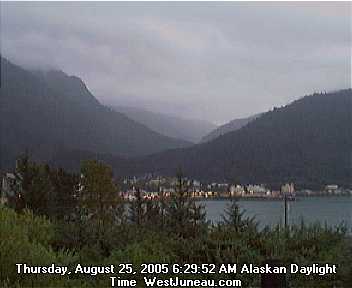
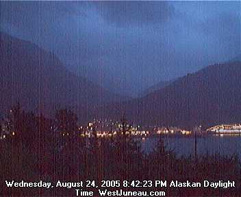
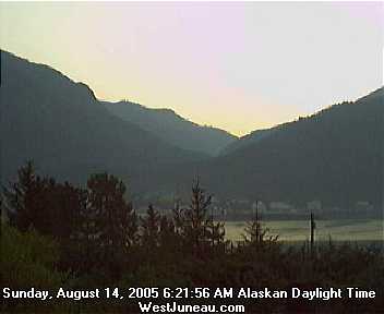
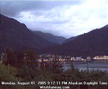
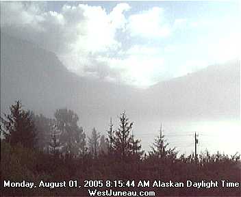
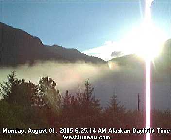