MONTHLY CLIMATOLOGICAL SUMMARY for APRIL 2005
CONDITIONS DAY of
Month: 1 2 3 4 5 6 7 8 9 10 11 12 13 14 15 16 17 18 19 20 21 22 23 24 25 26 27 28 29 30
NAME: 3270 Nowell   CITY: West Juneau   STATE: Alaska
ELEV:    97 ft  LAT: 58° 17' 33" N  LONG: 134° 25' 37" W


TEMPERATURE (°F), RAIN  (in), WIND SPEED (mph), SNOW (in). Snowfall from 21:00 - 21:00, all others Midnight to Midnight.

                                      HEAT  COOL        AVG                      WIND       SNOW
    MEAN                              DEG   DEG         WIND                DOM  RUN        ON(1)
DAY TEMP  HIGH   TIME   LOW    TIME   DAYS  DAYS  RAIN  SPEED HIGH   TIME   DIR  (mi)  SNOW GRND WEATHER
-----------------------------------------------------------------------------------------------------------------------------------------------------
 1  35.6  40.8  11:05a  30.6   6:15a  29.4   0.0  0.04   2.7  28.0   7:25p  ESE  63.48  0.2  0.2 DecrCld IncrCld Cld/Sn/LtSn-Rn M/PCld Cld Cld/Brz/Sn
 2  36.2  42.2  12:55p  32.2   1:10a  28.8   0.0  0.30   4.2  25.0   2:05a   SE 100.16  1.8  0.0 Sn/Windy Cld/Rn-Sn PCld MCld Cld Cld/VryLtSn&LtRn-Sn
 3  37.5  44.1   3:05p  32.9   1:30a  26.4   0.0  0.14   1.6  11.0   5:05a  WNW  40.41  0.2  0.0 Cldy/OccRn-Sn/Sn VarCld/OccLtRn-Spr Rnbow Cld/Rn
 4  37.6  42.8   2:05p  32.2   3:55a  27.4   0.0  0.09   2.0  16.0   5:25p   SW  48.08  0.0  0.0 Cld/Rn Sn? LoCld Cld/OccBrks&OccLtRn-Rn Rnbow VarCld
 5  43.1  49.1   2:35p  35.9   1:15a  21.9   0.0  0.10   6.9  35.0   8:35a   NE 165.53  0.0  0.0 Cld/Brzy Ovcst/Brz-Wind/Windy Cld/OccSpr Cld/LtRn-Rn
 6  41.5  51.7   2:20p  32.2  11:50p  23.5   0.0  0.03   1.9  11.0  11:50a  ESE  44.49  0.0  0.0 Cld/OccLtRn-Spr Cld/Brks MCld PCld MCld/Cld PCld Clr
 7  37.4  48.9   2:55p  28.2   5:40a  27.6   0.0  0.00   1.8  10.0   6:50p   SW  42.50 FRST  0.0 Clear MostlyClear Clear
 8  39.3  49.6   3:15p  28.2   5:55a  25.7   0.0  0.05   1.9  13.0   7:50p   SW  44.67 FRST  0.0 Clear MClear Clr/PCld Cld/MCld Cld/Spr-LtRn-Rn
 9  40.2  42.8   1:05p  38.5   5:25a  24.8   0.0  0.28   2.6  21.0   5:05p   SE  87.87  0.0  0.0 Cld/OccRn/Spr-Mist Cld/OccLtRn-Spr Cld/OccRn/Spr Rn
10  40.5  48.8   2:55p  35.9   7:10a  24.5   0.0  0.26   3.2  17.0  12:25a   SW  76.58  0.0  0.0 Cld/Rn(Sn-onMtns) Cld/SmBrks PCld-MCld MClr ThinClds
11  40.9  44.3   4:20p  38.5   3:40a  24.1   0.0  0.17   1.9  14.0   1:20a  ESE  45.75  0.0  0.0 Cldy Cldy/Spr-LtRn-Rn With CldyPeriods&OccBrks Rnbw
12  41.6  47.3   4:40p  36.8  11:35p  23.4   0.0  0.07   1.6  12.0   5:40p   SW  39.34  0.0  0.0 Cld/BitofRn Cld/MCld Cld/ThinAreas Cld/OccRn-LtRn
13  42.0  51.3   3:05p  36.0  12:00m  23.0   0.0  0.01   1.5  10.0   7:05p   SW  35.27  0.0  0.0 Cld/OccSpr MCld&Cld-Brks P/MCld PCld/Clr MCld
14  40.3  49.6   1:55p  32.4  12:00m  24.7   0.0  0.01   1.6  13.0  12:25p  SSW  39.38  0.0  0.0 Cld/Brks MCld OccLtRn-Spr P/MCld DecrCld MClr
15  42.7  52.0   4:40p  30.3   5:15a  22.3   0.0  0.00   4.0  28.0   2:10p   NE  95.11 FRST  0.0 Clear Brzy IncrOvcst Cld HiThin/VryThinClds
16  45.1  52.8  12:50p  34.9   4:40a  19.9   0.0  0.00   4.3  29.0   1:40p   NE 102.18  0.0  0.0 M/PCld P/MCld Brzy Ovcst/WeakSun Cld-OvcstwThinSpots
17  43.6  54.5   2:45p  34.9  11:35p  21.4   0.0  0.00   2.2  12.0   6:10p    S  52.17  0.0  0.0 Mcld/Cld cld/BrknSky VarPCld-MCldwSun PCld/Clr MClr
18  40.0  45.1  12:00p  33.7   1:45a  25.0   0.0  0.60   3.4  21.0   2:20p    E  81.50  0.0  0.0 Cldy Cldy/Rn(Snow on Mtns) OccBrzy
19  44.2  47.0   4:15p  40.9   1:40a  20.8   0.0  0.99   4.6  21.0   3:25a   SE 111.50  0.0  0.0 Cld/Rn Brzy Cld/Rn-LtRn-Spr
20  46.4  50.5   1:00p  43.5   2:25a  18.6   0.0  0.16   1.2  11.0  10:30p   SE  28.45  0.0  0.0 Cld-LwrBand ThinnishOvcst Cld/Rn-LtRn-Spr
21  47.2  55.7   1:15p  42.9  12:00m  17.8   0.0  0.24   2.1  13.0   2:05p   SE  49.56  0.0  0.0 Cld/Rn LoCld/Mist Cld/MCld Rnbws M/PCld MClr Cld
22  46.2  53.9   3:25p  36.6   5:15a  18.8   0.0  0.00   3.6  16.0  11:35p   SW  85.32  0.0  0.0 Cld/MCld MCld VarMostCldtoPartCld-Clear VryThinOvcst
23  49.1  64.5   3:05p  38.9   7:05a  15.9   0.0  0.00   3.1  19.0   5:05a   SW  74.10  0.0  0.0 PCld/MClr MostlyClear Clear
24  50.3  64.5   3:25p  37.9   5:15a  14.7   0.0  0.00   1.5   8.0   8:40a   SW  35.73  0.0  0.0 MostlyClear Clear
25  52.5  65.3   3:55p  39.2   5:40a  12.5   0.0  0.00   1.2   8.0   8:05p   SW  29.42  0.0  0.0 Clear MClr PCld/Clr HiThinOvcst with thinner areas
26  52.6  67.8   4:30p  39.9   5:10a  12.5   0.2  0.00   2.8  17.0  12:20p   SW  67.06  0.0  0.0 HiThinOvcst PCld/Clr HiThin/VryThinCld PCldy
27  57.1  68.1   3:10p  42.8   5:50a   8.2   0.3  0.00   4.1  29.0  11:45p   NE  97.91  0.0  0.0 PCld/Clr MClr VarPCld-MCldwHigh&MidLevelCld Brz-Wind
28  62.1  66.0   4:00p  58.7   6:30a   3.0   0.1  0.00   6.2  28.0   2:00a   NE 149.17  0.0  0.0 MOvcst Brz-Windy VarMCld-PCldwMostlyThin&VryThinClds
29  58.0  62.4   4:40p  52.8   4:55a   7.0   0.0  0.00   6.7  32.0  10:40a   NE 161.30  0.0  0.0 Clr/PCld Brzy-Windy VarPCld-ClrwHiThin&VryThinClds
30  55.6  60.7   3:25p  49.5  12:00m   9.4   0.0  0.00   5.2  32.0   9:45a   NE 125.48  0.0  0.0 PCld-Clear Brzy-Windy Clr PCld MClr MCld-Ovcst Brzy
-----------------------------------------------------------------------------------------------------------------------------------------------------
    44.9  68.1    27    28.2     7   603.0   0.6  3.54   3.1  35.0     5    SW 2194.39  2.2

(1) As measured on Front Lawn
STATISTICS | DATA | GRAPHS | CONDITIONS - DAY of MONTH: 1 2 3 4 5 6 7 8 9 10 11 12 13 14 15
16 17 18 19 20 21 22 23 24 25 26 27 28 29 30 | TOP
AVERAGE Mean Temp: 44.9
AVERAGE High Temp: 52.8
MINIMUM High Temp: 40.8 1st
MAXIMUM High Temp: 68.1 27th
AVERAGE Low Temp: 37.6
MINIMUM Low Temp: 28.2 7th, 8th
MAXIMUM Low Temp: 58.7 28th
MAX >= 90.0: 0
MAX >= 80.0: 0
MAX >= 70.0: 0
MAX <= 32.0: 0
MIN <= 32.0: 4 1st, 7th, 8th, 15th
MIN <= 0.0: 0
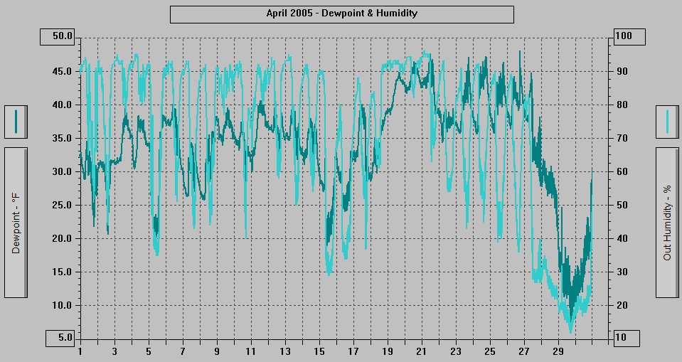
MAXIMUM Humidity (%): 96 21st @ 0307
MINIMUM Humidity (%): 12 29th @ 1647
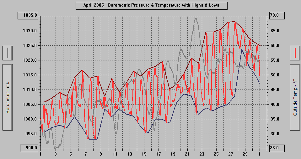
MAXIMUM Pressure (mb): 1034.3 22nd @ 0214
MINIMUM Pressure (mb): 990.0 2nd @ 2214
TOTAL Htg Deg Days: 603.0
AVERAGE Htg Deg Days: 20.1
MINIMUM Htg Deg Days: 3.0 28th
MAXIMUM Htg Deg Days: 29.4 1st
Total Cool Deg Days: 0.6
Heat Base: 65.0 Cool Base: 65.0 Method: Integration
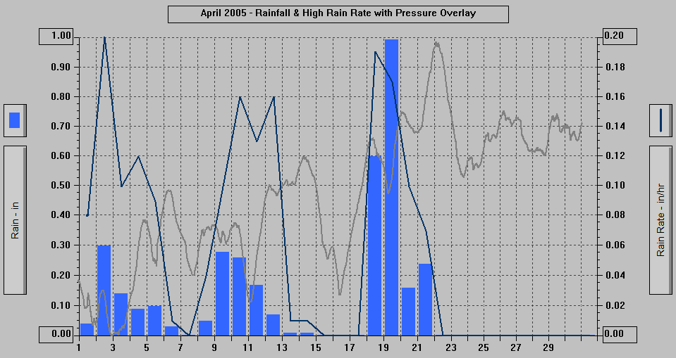
TOTAL Precip.: 3.54
AVERAGE Precip.: 0.2
DAYS of Precip.: 17
MAXIMUM Precip.: 0.99 19th
MAXIMUM Rain Rate: 0.20 2nd
Days of Rain: 15 (>.01 in) 9 (>.1 in) 0 (>1 in)
TOTAL Snowfall: 2.2
DAYS of Snowfall: 3 1st, 2nd, 3rd
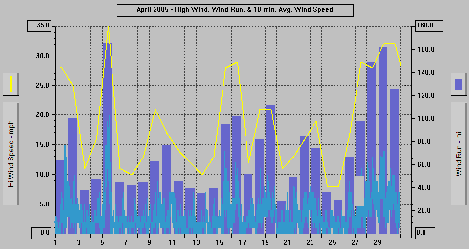
AVERAGE High Wind: 18.7
MINIMUM High Wind: 8 24th, 25th
MAXIMUM High Wind: 35 5th @ 0834
WIND RUN (miles): 2194.39
DAYS OF Sun: 25 All but 5th, 9th, 18th, 19th, 20th
Partly Cloudy to Clear: 4 7th, 23rd, 24th, 29th
DAYS OF Cld or M Cld: 26 All but 7th, 23rd, 24th, 29th
DAYS OF Rainbow: 4 3rd, 4th, 11th, 21st
DAYS OF Aurora: 1 4/30 part of 4/29-30 Night
DAYS OF Lightning: 0
DAYS OF Earthquake: 0
4/30/05: DATA | 1600: Wind Advisory extended until Noon
Sunday | 1500: Red Flag Warning for Dangerous
Fire Conditions Remains in Effect Until 6
PM Sunday 5/1 - See Below. | Wildfire near Hoonah - 4/29-30 | There are blossoms on the neighbor's
Cherry tree.
- 2050 ADT: Cloudy (overcast) with a few hints
of blue through the clouds, breezy.
- 2020: Cloudy (overcast) with a few thinner
spots where there are hints of blue through
the clouds, light to breezy wind.
- 1950: Overcast with thinner areas in the
SE part of the sky where blue is visible
through the clouds, light to breezy wind.
- 1850: High overcast with thin and very thin
clouds where blue is visible through the
clouds, very weak sunshine.
- 1750: Overcast with thinner spots where blue
is visible through the clouds, extremely
weak sunshine.
- 1650: Mostly Cloudy SE 2/3rds of the sky
with high thin and very thin clouds, mostly
clear NW 1/3rd, somewhat weakened sunshine.
- 1550: Clear NW 2/3rds of sky, partly/mostly
cloudy with high thin clouds SE part of sky.
- Akz018-025-020100-
Taiya Inlet and Klondike Highway-
including...Skagway
Juneau Borough and Northern Admiralty Island-
including...Juneau
300 pm ADT Sat Apr 30, 2005
...Red Flag Warning remains in effect until
6 pm Sunday due
to locally strong winds and low humidities
for Taiya Inlet and
Klondike Highway and the Juneau Borough
and
northern Admiralty
Island...
Fire weather zones included in this warning
are:
018-025
Discussion...An area of high pressure over
northwest Canada and
a weak low in the southeast Gulf will continue
to generate dry
offshore flow and northeast winds of 20
to
30 mph through Sunday.
Stronger northeast winds of up to 50 mph
funneling out of
interior passes will continue to effect
areas
such as Taku
Inlet...Downtown Juneau and Douglas through
Sunday morning.
Relative humidities have fallen into the
mid teens to lower 20s
in most areas so far this afternoon. Despite
maximum afternoon
temperatures a few degrees cooler than
yesterday...Minimum
humidities will only be slightly higher...Ranging
between 14 and
22 percent.
A weak front slowly lifting north through
the Panhandle will
gradually increase clouds and relative
humidities
from south to
north tonight through Sunday. The strong
offshore flow through
the mountain gaps in the Skagway and Juneau
areas will delay the
increase in moisture significantly. Relative
humidities tonight
will increase to around 30 percent where
they will remain through
much of Sunday. Winds will start slowly
diminishing
Sunday
afternoon as the pressure gradient slackens.
Station..........Min rh.....Max rh..........Min
rh as of
.................Friday.......Friday night...2
pm Saturday
Yakutat.............12..........92....................14
Skagway...........11..........26....................15
Haines...............13..........59....................16
Gustavus...........13..........45.....................16
Juneau Airport...12.........22.....................18
Juneau wfo..........9..........40....................
16
Sitka.................16..........62.....................21
Kake.................15.........69.....................22
Petersburg.........17.........69.....................
20
Wrangell............22.........70.....................32
Stewart..............13........Mm....................17
Please advise the appropriate officials
and
fire crews in the
field of this red flag warning.
$$
- 1459: First Orange Crowned Warbler of 2005
seen in the willow by the deck. The first
one in 2004 was seen on May 7.
- 1450: Clear with a small bit of high thin
clouds.
- 1350: Mostly Clear with some high very thin
clouds.
- 1250: Partly Cloudy NW 2/3rds of sky with
high thin clouds, clear SE 1/3rd, occasionally
breezy.
- 1150: Clear with a few tiny high clouds SE
part of sky, partly cloudy with high thin
clouds NW part of sky, breezy with occasional
stronger gusts, a few whitecaps on Gastineau
Channel.
- 1105: Mostly Clear with some high thin and
very thin clouds, breezy with occasional
stronger gusts, whitecaps on Gastineau
Channel.
- 1035: Mostly Clear with some high thin and
very thin clouds, breezy with occasional
stronger gusts, whitecaps on Gastineau
Channel.
- 0950: Clear with a small bit of high very
thin clouds, breezy with occasional stronger
gusts.
- 0850: Clear with a small bit of high very
thin clouds, breezy with occasional stronger
gusts.
- 800 AM ADT Sat Apr 30, 2005
...Red Flag Warning remains in effect until
9 pm Saturday due
to locally strong winds and low humidities
for Southeast
Alaska...
Fire weather zones included in this warning
are:
017-018-019-020-021-022-023-024-025-026-029
Discussion...An area of high pressure over
northwest Canada and
a weak low in the southeast Gulf will continue
to generate dry
offshore flow and northeast winds of 20
to
30 mph to Southeast
Alaska through Saturday.
Humidity recoveries between 50 and 70 percent
were more
widespread last night due to inversions
forming
in more
locations. However in Skagway and Juneau...Where
the wind
continued to blow all night...The maximum
humidities were only in
the 20s.
Sharp drops in the relative humidity and
increases in northeast
winds will occur between 8 am and 10 am
as
the remaining
inversions break. Despite maximum afternoon
temperatures a few
degrees cooler...Minimum humidities will
fall to a similar levels
as yesterday...Ranging between 10 and 20
percent.
A weak front slowly lifting north through
the Panhandle will
gradually increase clouds and relative
humidities
tonight through
Sunday.
Station...............Min rh.....Max rh.......Rh
at 7 am
.........................Friday...Friday
night...Saturday
Yakutat.................12.............92............85
Skagway...............11.............26............26
Haines...................13.............59............53
Gustavus................13.............45............45
Juneau Airport........12............22............22
Juneau wfo...............9............40............40
Sitka......................16............62.............51
Kake.....................15............69.............49
Petersburg.............17.............69............48
Wrangell................22.............70............56
Please advise the appropriate officials
and
fire crews in the
field of this Red Flag Warning.
$$
- 0750: Clear with a small bit of high very
thin clouds, breezy with occasional stronger
gusts, some whitecaps on Gastineau Channel.
- 0653: The Sun started rising over the north
end of Gold Ridge on Mt. Roberts.
- 0650: Clear with high thin clouds to the
NW, breezy with occasional stronger gusts.
- 0620 ADT: Clear with high thin clouds to
the NW, breezy at times. Overnight there
was some faint diffuse Aurora Borealis.
4/29/05: DATA | 1530: Wind Advisory in effect until 2
PM Saturday | 1600: Red Flag Warning for
Dangerous Fire Conditions Remains in Effect
Until 9 PM Saturday 4/30.
- 2050 ADT: Clear/Partly Cloudy SE part of
the sky, Clear NW part, light to breezy wind.
- 1950: Mostly Clear with some high thin clouds
in the SE part of the sky.
- 1850: Mostly Clear with some high thin clouds
to the SE, light to breezy wind..
- 1750: Clear with a small thin cloud to the
NW.
- 1650: Clear with a small high thin cloud.
- 400 pm ADT Fri Apr 29, 2005
...Red Flag Warning remains in effect until
9 pm Saturday due
to locally strong winds and low humidities
for Southeast
Alaska...
Fire weather zones included in this warning
are:
017-018-019-020-021-022-023-024-025-026-029
Discussion...An area of high pressure over
northwest Canada and
a weak low in the southeast Gulf will continue
to generate dry
offshore flow and northeast winds of 20 to
30 mph to Southeast
Alaska through Saturday.
Continued drying from strong offshore flow
has dropped relative
humidities into the teens in most locations
across Southeast
Alaska this afternoon. Winds will diminish
slightly as the
pressure gradient weakens through the evening...But
increase
again tonight through Saturday morning as
the ridge of high
pressure in Canada strengthens.
Humidity recoveries will generally be poor
again tonight...Only
reaching similar levels as they did last
night. Although
afternoon temperatures tomorrow will be 3
to 5 degrees cooler
than today...Minimum relative humidities
will be similar to those
seen this afternoon...Ranging between 10
and 20 percent.
Station...........Min rh....Max rh.......Min
rh as of
.................Thursday..Last night....3
pm Friday
Yakutat............ 28........ 92............12
Skagway...........20........ 31............13
Haines...............22........ 67............14
Gustavus............20........ 37............14
Juneau Airport....21....... 42............13
Juneau wfo.........19........43............10
Sitka..................26.........62...........
16
Petersburg.........18.........64............17
Wrangell.............24........70............21
please advise the appropriate officials and
fire crews in the
field of this Red Flag Warning.
$$
fnak57pajk_akz025
- 1605: Clear with a bit of high thin haze.
- 1450: Clear/Partly Cloudy with high thin
and very thin clouds and high thin haze,
occasionally breezy and occasional whitecaps
on the Channel.
- 1405: Partly Cloudy/Clear with high thin
and very thin clouds and high thin haze.
- 1250: Some high thin and very thin clouds
otherwise a high thin haze over most of the
sky and unimpeded sunshine.
- 1150: High very thin clouds and haze over
much of the sky, breezy with stronger gusts,
whitecaps on the Channel, slightly weakened
sunshine.
- 1050: High very thin clouds and haze over
much of the sky, breezy with stronger gusts,
whitecaps and blowing spray on the Channel,
slightly weakened sunshine.
- 0950: Clear with some high very thin haze
and clouds, windy, whitecaps and blowing
spray on the Channel.
- 0850: Partly Cloudy with mostly very thin
and some thin clouds, breezy with stronger
gusts, whitecaps and blowing spray on Gastineau
Channel.
- 0750: Mostly Clear NW part of sky, Partly/Mostly
Cloudy with high thin and very thin clouds
SE part, breezy-windy, weakened sunshine.
- 745 am ADT Fri Apr 29, 2005
...Red Flag Warning remains in effect until
9 pm this evening due
to locally strong winds and low humidities
for the Southeast
Alaska Panhandle...
Fire weather zones included in this warning
are:
018-019-020-021-022-023-024-025-026-027-028-029
Discussion...An area of high pressure over
northwest Canada and
an area of low pressure over the southeast
Gulf of Alaska will
continue to generate dry offshore flow and
windy conditions to
Southeast Alaska through today.
Strong winds through the night kept humidities
recoveries poor in
many locations last night. As of 7 am this
morning the relative
humidity in Juneau and several other locations
had already fallen
into the upper teens and lower 20s.
Gusty northeast to east winds and low relative
humidities will
become more widespread today as the remaining
inversions which
formed overnight break by around 8 am. Minimum
humidities will be
lower than yesterday ranging between 12 and
20 percent. Northeast
winds gusting to 35 mph are expected to gradually
diminish this
afternoon and evening.
STATION................... MIN RH............MAX
RH....... 7 AM RH
................................. THURSDAY.....LAST
NIGHT......FRIDAY
SKAGWAY.....................20......................
31................... 24
HAINES...........................22......................
67................... 62
GUSTAVUS.................... 20......................
37................... 18
JUNEAU.......................... 21.......................42....................19
SITKA............................. 26.......................
62................... 31
PETERSBURG................ 18........................64....................46
WRANGELL................... 24.......................
70....................43
KETCHIKAN...................18........................54...................
22
METLAKATLA................18........................28....................22
ANNETTE ISLAND........ 15........................26....................20
KLAWOCK......................14.......................40....................34
HYDABURG.................... 18.......................70....................20
Please advise the appropriate officials and
fire crews in the
field of this red flag warning.
This statement will be updated by 3 pm ADT
this afternoon or
sooner if conditions warrant.
$$
fpak77pajk_akz025
- 0650: Clear with a few small high thin clouds
except to the SE and East where it is mostly
cloudy with high thin clouds, breezy with
stronger gusts.
- 0620 ADT: Partly Cloudy/Clear (most of the
clouds in SE part of sky) with high thin
and very thin clouds, breezy with occasional
stronger gusts.
- 500 AM ADT FRI APR 29 2005 ...RED FLAG WARNING REMAINS IN EFFECT UNTIL
9 PM THIS EVENING DUE TO LOCALLY STRONG WINDS
AND LOW HUMIDITIES FOR THE SOUTHEAST ALASKA
PANHANDLE... FIRE WEATHER ZONES INCLUDED IN THIS WARNING
ARE: 018-019-020-021-022-023-024-025-026-027-028-029
DISCUSSION...AN AREA OF HIGH PRESSURE OVER
NORTHWEST CANADA AND AN AREA OF LOW PRESSURE
OVER THE SOUTHEAST GULF OF ALASKA WILL CONTINUE
TO GENERATE DRY OFFSHORE FLOW AND WINDY CONDITIONS
TO SOUTHEAST ALASKA THROUGH TODAY. GUSTY
NORTHEAST TO EAST WINDS AND LOW RELATIVE
HUMIDITIES WILL BECOME WIDESPREAD TODAY AS
INVERSIONS FORMED OVERNIGHT BREAK AROUND
8 AM. MINIMUM HUMIDITIES WILL RANGE BETWEEN
15 AND 25 PERCENT WITH NORTHEAST WINDS GUSTING
TO 35 MPH. WINDS ARE STILL EXPECTED TO GRADUALLY
DIMINISH THIS AFTERNOON AND EVENING. PLEASE
ADVISE THE APPROPRIATE OFFICIALS AND FIRE
CREWS IN THE FIELD OF THIS RED FLAG WARNING.
THIS STATEMENT WILL BE UPDATED BY 11 AM ADT
THIS MORNING OR SOONER IF CONDITIONS WARRANT.
$$ FPAK57PAJK_AKZ025
- Record high temperatures set across the Panhandle
Thursday 4/28
| NWS Record Report |
Statement as of 7:30 PM ADT on April 28,
2005
... Record high temperatures set across the
Panhandle Thursday...
Location | New Record | Old Record | Year
Set
Klawock ..........71.................68.............2003
Gustavus...........68.................68.............1995
Juneau...............67.................67.............1958
Wrangell............66.................64.............2003
Yakutat..............65.................64.............1979
Apr 05
|
4/28/05: DATA | Wind Advisory - Issued 1950 | Red Flag
Warning for Dangerous Fire Conditions - updated
1530 - See Below | Spruce buds are close
to opening and are opening. Juneau Airport
high temperature tied previous record of
67 degrees set in 1958.
- 2050 ADT: Partly/Mostly Cloudy with mostly
high thin and very thin clouds, breezy at
times.
- 1950: Partly/Mostly Cloudy with mostly thin
and very thin clouds, breezy at times with
occasional stronger gusts.
- 1850: Partly Cloudy with high thin and very
thin clouds SE half of sky, mostly cloudy/cloudy
with somewhat thin clouds and mid- level
clouds NW part.
- 1750: Partly/Mostly Cloudy with high thin
and very thin clouds SE half of sky, cloudy
with somewhat thin clouds and mid- level
clouds NW part, breezy at times, weak sunshine.
- 1650: Partly/Mostly Cloudy with high thin
and very thin clouds SE half of sky, overcast
with thin clouds NW part, breezy at times,
weakened sunshine.
- 1550: Mostly Cloudy with high thin and very
thin clouds/haze with blue visible in the
very thin areas, breezy, weakened sunshine.
- 330 PM ADT THU APR 28 2005 ...RED FLAG WARNING IN EFFECT UNTIL 9 PM
ADT FRIDAY DUE TO LOCALLY STRONG WINDS AND
LOW HUMIDITIES FOR THE SOUTHEAST ALASKA PANHANDLE... FIRE WEATHER ZONES INCLUDED IN THIS WARNING
ARE: 018-019-020-021-022-023-024-025-026-027-028-029
DISCUSSION...STRENGTHENING OFFSHORE FLOW
WILL CONTINUE TO BRING DRY WINDY CONDITIONS
TO SOUTHEAST ALASKA THROUGH FRIDAY. RELATIVE
HUMIDITIES AS OF 2 PM THIS AFTERNOON HAVE
FALLEN INTO THE MID TEENS IN THE SOUTHERN
PANHANDLE AND THE LOWER 20S ELSEWHERE. NORTHEAST
WINDS CURRENTLY GUSTING TO AROUND 25 MPH
ARE EXPECTED TO CONTINUE TO INCREASE THIS
AFTERNOON THROUGH FRIDAY MORNING. THESE WINDS...ALONG
WITH THE LOW RELATIVE HUMIDITIES...CONTINUE
TO CREATE DANGEROUS FIRE WEATHER CONDITIONS.
DESPITE THE INCREASE IN THE GENERAL WINDS...NIGHTTIME
INVERSIONS FORMING IN WIND SHELTERED AREAS
WILL ALLOW RED FLAG CONDITIONS TO BECOME
ISOLATED AFTER SUNSET. RELATIVE HUMIDITIES
ARE EXPECTED TO RECOVER TO BETWEEN 45 AND
55 PERCENT TONIGHT. STRONG GUSTY NORTHEAST
WINDS AND LOW RELATIVE HUMIDITIES WILL RETURN
TOMORROW MORNING WHEN THE INVERSIONS BREAK
AROUND 8 AM. MINIMUM HUMIDITIES WILL RANGE
BETWEEN 15 AND 25 PERCENT WITH NORTHEAST
WINDS GUSTING TO 35 MPH. WINDS ARE EXPECTED
TO GRADUALLY DIMINISH FRI AFTERNOON AND EVENING.
PLEASE ADVISE THE APPROPRIATE OFFICIALS AND
FIRE CREWS IN THE FIELD OF THIS RED FLAG
WARNING. THIS STATEMENT WILL BE UPDATED BY
11 PM ADT THU OR SOONER IF CONDITIONS WARRANT.
$$ FPAK77PAJK_AKZ025
- 1450: Partly/Mostly Cloudy with high thin
and very thin clouds/haze with blue visible
in the very thin areas, breezy at times,
weakened sunshine.
- 1420: Partly Cloudy with mostly high thin
and very thin clouds, breezy, a few small
whitecaps on Gastineau Channel, weakened
sunshine.
- 1350: Partly/Mostly Cloudy with mostly somewhat
thin clouds and thinner clouds, breezy with
stronger gusts, weak sunshine.
- 1250: Partly/Mostly Cloudy with mostly somewhat
thin clouds and thinner clouds, breezy with
stronger gusts, weakened sunshine.
- 1150: Mostly overcast with thinnish high
and mid-level clouds in the SE part of the
sky and mostly/partly cloudy NW part, weak
sunshine, extremely weak sunshine within
the past hour.
- 1050: Mostly overcast with thinnish high
and mid-level clouds in the SE part of the
sky and mostly/partly cloudy NW part, weak
sunshine.
- 0950: Mostly/Partly Cloudy with high and
mid-level clouds, weak sunshine.
- 0850: Mostly overcast with high and mid-level
clouds, weakened sunshine, breezy at times.
- 0750: Mostly Cloudy with high and mid-level
clouds, weak sunshine, breezy at times.
- 0650: Mostly Cloudy NW part of sky and partly/mostly
cloudy SE part with high and mid-level clouds,
breezy at times.
- 0620 ADT: Mostly overcast with high and mid-level
clouds with thinner areas where blue is visible,
breezy.
- Breezy-Windy overnight.
- Record high temperatures set across Southeast
Alaska on 4/27:
| NWS Record Report |
Statement as of 7:15 PM ADT on April 27,
2005
... Record high temperatures set across Southeast
Alaska...
For the fifth consecutive day... a record
high temperature has been
tied or set across Southeast Alaska. Today
marked the fourth 70
degree reading for Skagway... Haines... Annette
Island... and the
Juneau forecast office in the past week.
Wednesday's high
temperature of 72 degree at the Juneau International
Airport is the
second earliest 70 reading for the city which
normally occurs on
May 31.
Location | New Record | Old Record | Year
Set
Haines..............72.................71.............2003
Juneau..............72.................72.............1995
Ketchikan.........71.................70.............1958
Wrangell...........70.................60.............1998
Gustavus...........70.................70.............1958
Mm Apr 05
|
4/27/05: DATA | High temperature of 72 degrees at the
Juneau Airport tied the previous record set
in 1995. High of 68.1 degrees at 3270 Nowell
did not exceed the Record High of 71 degrees
set in 1995.
- NOTE: There were some mid-level clouds in
the afternoon and evening.
- 2050 ADT: Mostly Overcast with high clouds
and very thin clouds/haze, occasional gusts.
- 2032: A Bald Eagle is soaring high over Gastineau
Channel.
- 1950: Mostly Cloudy NW part of sky with high
mostly thin clouds, partly cloudy SE part
with high clouds.
- 1947: The Red Winged Blackbird is still here
vocalizing; left at 1948 as I was typing
this.
- 1915: A Red Winged Blackbird (a male) is
in the willow by the deck singing, tweeting,
and chucking. First time one has been here
since March 27, 2004.
- 1858: 6 Mountain Goats spotted on Mt. Juneau
to the right of the main waterfall.
- 1850: Partly/Mostly Cloudy with high clouds
of variable thickness, weak sunshine.
- 1750: Partly Cloudy with high clouds, thin
haze in the "clear" areas, slightly
weakened sunshine, occasionally breezy.
- 1650: Partly/Mostly Cloudy with high clouds,
weakened sunshine.
- 1550: Partly Cloudy with high clouds SE part
of the sky, Mostly Cloudy/Cloudy with high
clouds NW part, weak sunshine.
- 1450: Partly/Mostly Cloudy with high clouds,
breezy, weakened sunshine.
- 1350: Mostly/Partly Cloudy with high clouds,
weak sunshine, breezy.
- 1320: Partly/Mostly Cloudy with high clouds,
somewhat weakened sunshine, breezy.
- 1250: Partly Cloudy/Clear with cirrus NW
half of sky, Mostly Cloudy with high mostly
thin clouds SE half, breezy at times, weakened
sunshine.
- 1150: Partly Cloudy with cirrus clouds, slightly
weakened sunshine.
- 1050: Mostly Clear NW half of sky, partly/mostly
cloudy with cirrus clouds SE half.
- 0950: Partly Cloudy with cirrus (Mares' tails)
clouds.
- 0850: Partly Cloudy/Clear with cirrus (Mares'
tails) clouds.
- 0750: Clear/Partly Cloudy with high very
thin clouds.
- 07:01:52: The Sun started rising over Gold
Ridge on Mt. Roberts.
- 0650: Mostly Clear but with some high very
thin clouds and a bit of high thin haze.
- 0620: Partly Cloudy/Clear with some high
very thin clouds and haze.
- 0436 ADT: A Robin is singing.
- One village recorded a new high temperature
record for April 26:
| NWS Record Report |
Statement as of 3:30 am ADT on April 27,
2005
... Record temperature broken today in the
northern Panhandle...
Location | New Record | Old Record | Year
Set
Hoonah...........65...................63............1979
Apr 05 |
- 2050 ADT: Partly Cloudy with high thin and
very thin clouds, clouds highlighted orange
by the sun.
- 1950: Partly Cloudy with high thin and very
thin clouds (and thin haze in the "clear"
areas), slightly weakened sunshine.
- 1850: Partly Cloudy with high thin and very
thin clouds, slightly weakened sunshine.
- 1750: Partly/Mostly Cloudy with high thin
and very thin clouds, extremely weak sunshine.
- 1650: Partly Cloudy with high thin and very
thin clouds, weak sunshine.
- 1550: Mostly Clear (some high thin haze)
with thin overcast just to the SE, and thin
overcast further to the NW.
- 1450: Partly Cloudy with high thin and very
thin clouds, slightly weakened sunshine.
- 1350: Partly Cloudy with high thin and very
thin clouds - mostly clear overhead, somewhat
weakened sunshine.
- 1250: High thin overcast over most of the
sky with thinner areas where blue is visible
through the clouds, weak sunshine.
- 1150: High thin overcast with thinner spots
where there are hints of blue, weakened sunshine.
- 1050: Overcast with high mostly thin clouds
with a few thinner areas where there are
hints of blue, very weak sunshine.
- 0950: High thin and very thin clouds over
the sky with blue visible in areas through
the clouds, very weak sunshine.
- 0920: High thin and very thin clouds over
much of the sky, weakened sunshine.
- 0850: Partly Cloudy NW part of sky, high
thin clouds SE part, somewhat weakened sunshine.
- 0750: Partly Cloudy/Clear with high thin
and very thin clouds.
- 0703: The Sun started rising over Gold Ridge
on Mt. Roberts.
- 0650: High thin overcast with thinner areas
where blue is visible through the clouds.
A Bald Eagle is in his tree to the East along
the shore as usual.
- 0620 ADT: High thin overcast with thinner
areas where blue is visible through the clouds.
- Record temperatures set in the northern Panhandle
on 4/25:
| NWS Record Report |
Statement as of 10:00 PM ADT on April 25,
2005
... Record temperatures broken today in the
northern Panhandle...
Location | New Record | Old Record | Year
Set
Yakutat............68...................66............2003
Skagway..........74...................74............2003
Haines..............72...................72............2003
Gustavus..........66....................63...........1958
Hoonah............68....................66...........1983
Apr 05 |
- 2050 ADT: High thin overcast with thinner
areas.
- 1950: High thin overcast with thinner areas
where blue is visible through the clouds.
- 1850: Overcast with high thin clouds and
thinner areas where blue is visible, extremely
weak sunshine.
- 1750: Overcast with high thin clouds and
thinner areas where blue is visible, weak
sunshine.
- 1650: High thin and very thin clouds with
blue visible through the clouds over most
of the sky, weakened sunshine.
- 1550: High thin and very thin clouds with
blue visible through the clouds, and haze
over much of the sky, slightly weakened sunshine.
- 1450: Mostly Clear with some high very thin
clouds and haze.
- 1420: Clear/Partly Cloudy with some high
very thin clouds.
- 1350: Partly Cloudy/Clear with high thin
and very thin clouds and haze.
- 1250: Partly Cloudy/Clear with high thin
and very thin clouds and haze.
- 1150: Partly Cloudy/Clear with high thin
and very thin clouds and haze.
- 1050: Overcast with high thin clouds in the
SE part of the sky, High thin and very thin
clouds with blue visible in the NW part,
somewhat weakened sunshine.
- 0950: High very thin clouds and haze over
much of the NW half of sky, high thin overcast
SE half, slightly weakened sunshine. At least
2 Mountain Goats are visible on Mt. Juneau,
one on the cliffs to the right of the main
waterfall above Last Chance Basin and one
in the brush to the left of the waterfall
and higher.
- 0920: Mostly Clear NW 2/3rds of sky with
some high thin and very thin clouds and haze,
high thin overcast SE 1/3rd of sky.
- 0850: Mostly Clear with some high thin and
very thin clouds and haze.
- 0750: Clear.
- 0706: The Sun started rising over the center
of Gold Ridge on Mt. Roberts.
- 0650: Clear with some high thin clouds far
to the NW over the Mendenhall Valley.
- 0620: Clear, but with high clouds to the
NW.
- 0426 ADT: A Robin is singing.
- Record High Temperatures were set April 24
in parts of Southeast Alaska:
| NWS Record Report |
Statement as of 11:55 PM ADT on April 24,
2005
... Record temperatures across Southeast
Alaska...
Location | New Record | Old Record | Year
Set
Skagway........74...................70..............2003
Haines............71...................69..............2003
Gustavus........ 68..................64..............1956
Hoonah..........68...................65..............1983
Klawock........81...................73..............2003
Annette wso...74...................70..............1983
Apr 05 |
SUNDAY 4/24/05: DATA
- 2050 ADT: Clear.
- 1950: Clear.
- 1907: The Sun set behind the Douglas Island
mountains. 11 hrs. 59 mins. of direct sunshine
at 3270 Nowell.
- 1850: Clear.
- 1750: Clear.
- 1650: Clear.
- 1550: Clear.
- 1450: Clear.
- 1350: Clear.
- 1250: Clear.
- 1150: Clear, with a small bit of high very
thin clouds to the NW.
- 1050: Clear with some high very thin clouds/haze.
- 0950: Clear with a bit of high very thin
clouds to the NW and some to the SE.
- 0850: Clear with a bit of high very thin
clouds to the NW.
- 0750: Clear but still with some high very
thin haze/clouds.
- 0708: The Sun started rising over Gold Ridge
of Mt. Roberts.
- 0650: High very thin clouds over much of
the sky. A Robin is singing.
- 0620 ADT: High very thin clouds over much
of the sky. A Bald Eagle is in it's tree
to the East along the shore as normal.
- Record High Temperatures were set April 23:
| NWS Record Report |
Statement as of 10:30 PM ADT on April 23,
2005
... Record temperatures across Southeast
Alaska...
Location | New Record | Old Record | Year
Set
Skagway........71...................69..............1931
Haines............68...................68..............1979
Gustavus........ 63..................61..............1996
Hoonah...........65..................58..............1996
Juneau.............65..................65..............1997
Wrangell..........68..................58..............1998
Annette wso....76..................69...............1997
Klawock.........76..................63...............1983
Jer Apr 05 |
4/23/05: DATA | New Record High at 3270 Nowell Ave. for
this date: 64.5 degrees, exceeding previous
high of 62.7 set in 1993 and 1994. The Juneau
Airport tied the previous record of 65 degrees
set in 1997.
- 2050 ADT: Clear.
- 1950: Clear.
- 1850: Clear.
- 1750: Clear with a few wisps of high thin
clouds overhead.
- 1701: A flock of seagulls is flying NW over
Douglas Highway.
- 1650: Mostly Clear with a bit of high very
thin clouds/haze.
- 1550: Clear with some thin and very thin
high clouds to the SE.
- 1450: Clear with a small bit of high thin
clouds to the SE.
- 1350: Clear.
- 1250: Clear with a few wisps of high very
thin clouds to the ENE.
- 1150: Clear with a small bit of very thin
high clouds to the ENE.
- 1050: Clear with a small bit of very thin
high clouds to the ENE.
- 0950: Clear.
- 0850: Clear, a bit of high thin clouds to
the SE.
- 0750: Mostly Clear with some high thin and
very thin clouds in the SE and ESE part of
the sky.
- 0711: The Sun started rising over Gold Ridge
of Mt. Roberts.
- 0650: Mostly Clear (as described below) with
a lower band of fog lit by the sun over Gastineau
Channel hiding most of the upper part of
Mt. Juneau.
- 0635: Mostly Clear with high very thin haze/clouds
in the SE half of the sky at least, a few
thicker clouds to the SE, lower wisps and
bits of fog/clouds over Gastineau Channel
being blown to the SE.
- 0620 ADT: Mostly Clear with high very thin
haze/clouds in the SE half of the sky at
least, a few thicker clouds to the S
- 2050 ADT: High Thin and Very Thin Clouds
over most of the sky, some of the clouds
are highlighted in orange by the sun, the
moon is visible to the SE through the thin
layer.
- 1950: Overcast with somewhat thin clouds
to very thin clouds.
- 1859: A Squirrel drank from the Bird Bath.
- 1850: Mostly Cloudy/Cloudy SE 1/2 of sky,
Partly Cloudy NW part with mostly high thin
and very thin clouds, sun is shining.
- 1750: High Thin and Very Thin Clouds and
Haze over much of the sky, slightly weakened
sunshine.
- 1650: Partly Cloudy with mostly high thin
clouds.
- 1550: Partly Cloudy with somewhat weakened
sunshine.
- 1450: Partly Cloudy (including cirrus clouds),
a bit of fog/clouds skimming the top of Mt.
Juneau and the Mt. Juneau Ridge.
- 1350: Partly/Mostly Cloudy, Cloudy to the
NW, weakened sunshine, clouds skimming Mt.
Juneau and the Mt. Juneau Ridge.
- 1250: Partly Cloudy/Clear.
- 1220: Partly Cloudy, Cloudy to the NW, sun
is shining.
- 1150: Cloudy with thin areas, small breaks
and hints of breaks, extremely weak sunshine,
cloudy to the NW, clouds skimming the mountaintops.
- 1050: Cloudy with thin semi-broken areas
where blue is visible, hints of breaks, very
weak sunshine, clouds skimming the mountaintops.
- 0950: Cloudy with a few thin spots and breaks,
clouds skimming the mountaintops, weakened
sun going in and out..
- 0850: Mostly Cloudy with clouds skimming
Mt. Juneau and Mt. Roberts, a bit of fog/clouds
around the Mt. Juneau Ridge, weakened sun
going in and out.
- 0750: Cloudy with bright spots, sun breaking
through the clouds, clouds skimming the mountaintops,
tiny breaks, partly cloudy/clear to the SE.
- 0650: Cloudy with a few thin spots and hints
of breaks, partly cloudy to the SE, fog/clouds
around the very top of Mt. Juneau and the
Mt. Juneau Ridge.
- 0620 ADT: Cloudy with fog/clouds around the
very top of Mt. Juneau and the Mt. Juneau
Ridge, partly cloudy SE of Sheep Creek.
4/21/05: DATA | The Rhubarb is growing like Jack's beanstalk.
- 2050 ADT: Cloudy with a few small breaks.
- 2042: "Tiny" Squirrel drank from
the Bird Bath.
- 2020: Cloudy with a few tiny breaks.
- 1950: Mostly Cloudy.
- 1920: Partly Cloudy.
- 1850: Mostly Clear, Partly Cloudy to the
NW, some fog/clouds around the very top of
Mt. Juneau and the Mt. Juneau Ridge.
- 1750: Partly Cloudy/Clear SE 1/2 of the sky,
mostly cloudy/cloudy NW part, fog/clouds
around the very top of Mt. Juneau and the
Mt. Juneau Ridge.
- 1720: Mostly/Partly Cloudy, Clouds skimming
the top of Mt. Juneau and the Mt. Juneau
Ridge.
- 1718: A Squirrel drank from the Bird Bath.
- 1650: Mostly Cloudy with spots of sunshine
here and there on the mainland mountaintops.
- 1550: Mostly Cloudy, a bit of fog/clouds
around the very top of Mt. Juneau, Mt. Juneau
Ridge in the clouds, spots of sunshine here
and there.
- 1520: Long very shallow arced Rainbow - somewhat
faint, low to the NE centered over Mt. Maria.
- 1511: Partial very shallow arced Rainbow
low to the ENE (precipitation over downtown
and Mt. Juneau). Faded out by 1518.
- 1450: Mostly Cloudy, Sun shining, very tops
of the mountains in the clouds, precipitation
in the inner Gold Creek valley.
- 1442: Rainbow is even flatter and lower,
but brighter, with it's center just to the
left of the Federal Building, it disappeared
by 1445.
- 1435: Very faint shallow arced Rainbow to
the NE.
- 1420: Extremely Light Sprinkling, Cloudy
with some breaks, very tops of the mountains
in the clouds, areas of weak sunshine.
- 1350: Extremely Light Sprinkling, Cloudy/Mostly
Cloudy with spots of weak sunshine here and
there on the mainland.
- 1250: Cloudy with a few small breaks, spots
of sunshine on Mt. Roberts.
- 1235: Cloudy with some breaks, a bit of fog/clouds
around the very tops of the mountains.
- 1150: Cloudy with breaks, sun shining at
times, clouds skimming the top of Mt. Juneau
and some fog/clouds around the very top of
Mt. Roberts, a few lower wisps.
- 1050: Mostly Cloudy/Cloudy, a few lower wisps,
some fog/clouds in Last Chance Basin.
- 1047: A Bald Eagle flew East over the house.
- 1036: The Sun is trying to break through.
- 1020: Cloudy with a lower band of fog/clouds.
- 0950: Cloudy with the clouds skimming the
top of Mt. Juneau, the very top of Mt. Roberts
and the top of the Mount Juneau Ridge in
the clouds.
- 0935: Cloudy with the very tops of the mountains
in the clouds, some fog/clouds in Last Chance
Basin and on the Channel side of Mt. Roberts,
Blueberry Hills in fog/clouds..
- 0920: Extremely Light Misting, Cloudy with
the mountaintops in the clouds and some lower
fog/clouds, Blueberry Hills in fog/clouds.
- 0850: Light Rain/Drizzle, Cloudy with lower
fog/clouds and mists hiding and partially
obscuring much of Mt. Roberts and Last Chance
Basin and a portion of Mt. Juneau, Blueberry
Hills in fog/clouds (and think it has been
since 0730).
- 0750: Misting, Cloudy with fog/clouds hiding
the mainland above the 300' - 400' elevation.
- 0735: Misting, Cloudy with fog/clouds hiding
the mainland above the 300' - 400' elevation.
- 0650: Rain, Cloudy with the mountaintops
in the clouds, lower ribbons and wisps of
fog/clouds.
- 0620 ADT: Rain, Cloudy with the mountaintops
in the clouds, lower bits and wisps of fog/clouds.
4/20/05: DATA | Willow trees-shrubs: Catkins have developed,
leaves are popping out. The leaves are also
emerging on the Alders.
- 2050 ADT: Cloudy with a few lower wisps.
- 1950: Sprinkling, Cloudy with the clouds
skimming the mountaintops, some lower wisps
of fog/clouds NW of Gold Creek.
- 1850: Extremely Light Sprinkling/Misting,
Cloudy with a few lower wisps and ribbons.
- 1820: Cloudy with a few lower wisps and ribbons
(would come and go).
- 1750: Sprinkling, Cloudy with a few lower
wisps.
- 1650: Rain, Cloudy with a few lower wisps.
- 1550: Rain, Cloudy with a few lower wisps
over the Channel slope of Mt. Juneau.
- 1520: Light Rain, Cloudy with a lower fog/cloud
over the Channel slope of Mt. Juneau.
- 1450: Sprinkling/Very Light Rain, Cloudy
with a few lower wisps.
- 1435: Sprinkling, Cloudy with a few lower
wisps.
- 1350: Very Light Rain, Cloudy with a few
lower wisps.
- 1320: Sprinkling, Cloudy with some fog/clouds
around Mt. Juneau.
- 1318: A Red Crossbill drank from the Bird
Bath.
- 1250: Extremely Light Sprinkling/Misting,
Cloudy (overcast) with a few lower wisps.
- 1150: Overcast with a few lower wisps of
fog/clouds over the Channel slope of Mt.
Juneau.
- 1050: Overcast, location of the sun is visible,
a few lower bits and wisps of fog/clouds
on the Channel side of Mt. Juneau and over
Last Chance Basin.
- 0950: Somewhat thin overcast, extremely weak
sunshine, a lower fog/cloud over the Channel
slope of Mt. Juneau.
- 0850: Cloudy - overcast, the location of
the sun is visible, a few lower wisps.
- 0750: Cloudy with lower band and ribbons
of fog/clouds.
- 0735: Cloudy with a lower band/ribbon of
fog/clouds.
- 0650: Cloudy with thin spots, tiny breaks,
and hints of breaks, lower fog/clouds hiding
most of Mt. Juneau and all of Last Chance
Basin.
- 0620 ADT: Cloudy with hints of breaks, clouds
skimming the top of Mt. Juneau, lower band/ribbon
of fog/clouds.
4/19/05: DATA | Fairbanks Street re-opened today after
being closed for the winter. Record 1.07"
precip. for this date set at the Juneau Airport,
exceeding previous record of .80" set
in 1982. West Juneau Weather Station had
.99"; previous record was .77"
in 1986 (no records prior to that for April).
- 2050 ADT: Cloudy with fog/clouds around the
top of Mt. Juneau and Mt. Roberts and a few
lower wisps.
- 2020: Very Light Sprinkling/Misting, Cloudy
with fog/clouds around the top of Mt. Juneau
and Mt. Roberts.
- 1950: Rain, Cloudy with the ceiling at about
1700' - 1800', a few lower wisps.
- 1850: Rain, Cloudy with the ceiling at about
1500' - 1700'.
- 1750: Light Rain, Cloudy with the ceiling
at about 1700', a few lower wisps.
- 1720: Sprinkling, Cloudy with the mountaintops
in the clouds.
- 1650: Rain, Cloudy with the very tops of
the mountains in the clouds.
- 1620: Very Light Rain, Cloudy with some fog/clouds
around the top of Mt. Juneau, Mt. Juneau
Ridge hidden, and the top of Mt. Roberts
in the clouds.
- 1550: Sprinkling/Misting, Cloudy with bright
spots, mountaintops in the clouds - ceiling
at about 1700' - 1800', a few lower wisps.
- 1535: Rain, Cloudy with the mountaintops
in the clouds - ceiling at about 1700'.
- 1505: Very Light Rain/Drizzle, Cloudy with
fog/clouds around the mountaintops.
- 1450: Light Rain, Cloudy with the fog/clouds
as low as 1000' - 1200' and below, fog/clouds
hiding the inner Gold Creek valley and part
of Last Chance Basin.
- 1420: Rain, Cloudy with the ceiling at about
1500', a few whitecaps on the Channel.
- 1350: Rain, Cloudy with the mountaintops
in the clouds and the mainland slightly obscured,
a few whitecaps on the Channel.
- 1250: Rain, Cloudy with the mountaintops
in the clouds and the mainland partially
obscured, some whitecaps on the Channel.
- 1150: Rain, Cloudy with the mountaintops
in the clouds, some whitecaps on the Channel.
Uploading problems continuing.
- 1120: Rain, Breezy at times, cloudy with
the mountaintops in the clouds, whitecaps
on the Channel.
- 1050: Light Rain/Drizzle, Breezy at times,
cloudy with the mountaintops in the clouds,
whitecaps on the Channel.
- 0950: Rain, Breezy at times, cloudy with
the mountaintops in the clouds, whitecaps
on the Channel.
- 0905: Rain, Breezy, Cloudy with the mountaintops
in the clouds and the mainland below that
partially obscured, some whitecaps on the
Channel.
- 0850: Rain, Cloudy with the mountaintops
in the clouds, breezy at times here and breezy-windy
over the Channel with some whitecaps on the
Channel. Uploading difficulties are back.
- 0820: Rain, Cloudy with the very tops and
the tops of the mountains in the clouds and
the mainland below that partially obscured,
breezy-windy over Gastineau Channel with
a few whitecaps.
- 0750: Rain, Cloudy with fog/clouds around
the very tops and tops of the mountains.
- 0650: Rain, Cloudy with the very top of Mt.
Juneau and top of Mt. Roberts in the clouds.
- 0620 ADT: Rain, Cloudy with the very tops
of the mountains in the clouds and a few
lower wisps.
4/18/05: DATA | Wind Advisory - In effect 4 PM today to
6 AM Tuesday 4/19
- 2050 ADT: Rain, Cloudy with the ceiling at
about 2500', breezy at times with occasional
stronger gusts.
- 1950: Rain, Cloudy with the very tops of
the mountains in the clouds and a few lower
wisps.
- 1850: Rain, Cloudy with the very tops of
the mountains in the clouds.
- 1750: Rain, Cloudy with the very top of Mt.
Roberts and the Mt. Juneau Ridge in the clouds,
clouds skimming the top of Mt. Juneau, a
few lower wisps, a few whitecaps on the Channel.
- 1650: Rain (snow at the higher elevations),
cloudy with mountaintops in the clouds.
- 1635: It is snowing on the mountains above
the approximately 1200' elevation.
- 1550: Rain, Cloudy with the mountaintops
in the clouds - ceiling 1700' - 1800'.
- 1512: A Steller's Jay is taking a bath in
the Bird Bath.
- 1450: Rain, Cloudy with the mountaintops
in the clouds, breezy, inner Gold Creek valley
obscured.
- 1420: Rain, Cloudy with the very tops of
the mountains in the clouds, inner Gold Creek
valley obscured, a few whitecaps on the Channel,
breezy.
- 1405: Light Rain, Cloudy with very tops of
the mountains obscured, some whitecaps on
the Channel.
- 1350: Cloudy, some whitecaps on the Channel.
- 1250: Cloudy, a few whitecaps on the Channel.
- 1150: Cloudy, a few whitecaps on Gastineau
Channel.
- 1134: British Petroleum's brand new 941',
1.3 million barrel double hull oil tanker
"Alaskan Explorer" is coming into
view from here. It will be here on a brief
visit before heading to Valdez for it's first
load of crude oil from the TransAlaska Pipeline.
This is the first time an oil tanker of this
size has been in Juneau.
- 1050: Cloudy.
- 0950: Cloudy with the clouds skimming the
mountaintops at times, very light precipitation
over parts of the mainland mountains, occasionally
a few whitecaps on Gastineau Channel.
- 0850: Cloudy with very light precipitation
over parts of the mainland mountains.
- 0750: Cloudy. light precipitation over parts
of the mainland.
- 0720: Cloudy with clouds skimming the mountaintops,
there has been light precipitation over the
mainland.
- 0650: Cloudy with clouds skimming Mt. Juneau
and some fog/clouds around the very top of
Mt. Roberts, top of Mt. Juneau was visible
at 0635.
- 0620 ADT: Cloudy with a few tiny breaks overhead,
clouds skimming Mt. Juneau and some fog/clouds
around the very top of Mt. Roberts.
SUNDAY 4/17/05: DATA
- 2050 ADT: Clear with some clouds to the ESE.
- 2029: First Hummingbird to drink at the Hummingbird
Feeder in 2005.
- 1950: Mostly Clear.
- 1850: Mostly Clear.
- 1846: The Sun set behind the Douglas Island
mountains.
- 1835: Mostly Clear.
- 1750: Partly Cloudy/Clear.
- 1650: Partly/Mostly Cloudy.
- 1550: Partly Cloudy.
- 1520: Partly/Mostly Cloudy.
- 1450: Partly Cloudy.
- 1350: Partly Cloudy.
- 1250: Partly Cloudy, a few whitecaps on the
Channel.
- 1232: A Golden Crowned Sparrow in the willow
by the deck, first one seen in 2005.
- 1220: Partly Cloudy, whitecaps on Gastineau
Channel.
- 1150: Mostly/Partly Cloudy with weak sunshine
here and there on the mainland.
- 1050: Mostly Cloudy.
- 0950: Partly Cloudy, Sun is shining.
- 0850: Cloudy/Mostly Cloudy with broken skies
and breaks and the sun has been shining.
- 0842: The Sun broke through the clouds.
- 0750: Cloudy/Mostly Cloudy with broken skies
and breaks.
- 0650: Cloudy with broken skies.
- 0620 ADT: Cloudy with broken skies.
- 2050 ADT: Cloudy with small breaks and thin
spots, moon visible, thinner clouds and "clearer"
to the NW.
- 2035: Cloudy with hints of breaks and a few
thin spots.
- 1952: A Bald Eagle flew SW over the house.
- 1950: Overcast, thin in areas - can see the
moon.
- 1920: Overcast with a somewhat thin cloud
layer, thicker clouds to the SE.
- 1850: Cloudy.
- 1750: Cloudy.
- 1650: Cloudy (overcast).
- 1550: Cloudy (overcast), breezy at times.
- 1450: Cloudy with bright skies, some precipitation
over part of Mt. Roberts.
- 1420: Cloudy with bright skies and extremely
weak sunshine, breezy at times.
- 1350: Cloudy with bright skies, occasional
gusts of wind.
- 1250: Mostly Overcast with bright skies and
thin and very thin clouds in areas with blue
visible through the clouds, weakened sunshine,
breezy at times
- 1235: Overcast with bright skies and thin
and very thin clouds in areas with blue visible
through the clouds, weakened sunshine, breezy
at times, a few whitecaps on the Channel.
- 1150: Overcast with bright skies, small partially
broken area overhead, extremely weak sunshine,
breezy at times.
- 1050: Mostly Overcast with areas of thin
and very thin clouds where blue is visible,
breezy at times with occasional stronger
gusts, weak sunshine, some whitecaps on the
Channel, some snow is still blowing off Mt.
Roberts and the Mt. Juneau Ridge.
- 1020: Mostly Overcast with large areas of
thin and very thin clouds where blue is visible,
extremely weak sunshine, occasionally breezy
with stronger gusts.
- 0950: Partly/Mostly Cloudy, Breezy with occasional
stronger gusts, some whitecaps on the Channel,
weak sunshine.
- 0850: Partly Cloudy SE part of the sky, Cloudy
NW part, Breezy with occasional stronger
gusts, whitecaps on Gastineau Channel, snow
blowing off Mt. Roberts and the Mt. Juneau
Ridge.
- 0820: Partly Cloudy SE part of the sky, Cloudy
NW part, Breezy with stronger gusts, whitecaps
and blowing spray on Gastineau Channel, snow
blowing off Mt. Roberts.
- 0750: Partly Cloudy SE part of the sky, Mostly
Cloudy NW part, Breezy with stronger gusts,
snow blowing off Mt. Roberts.
- 0650: Partly Cloudy SE part of the sky, mostly
cloudy/cloudy NW part, tiny bit of snow is
blowing off Mt. Roberts at the saddle between
Gold Ridge and Gastineau Peak.
- 0620 ADT: Partly Cloudy SE part of the sky,
mostly cloudy/cloudy NW part, some snow is
blowing off Mt. Roberts at the saddle between
Gold Ridge and Gastineau Peak. A Robin is
singing.
4/15/05: DATA | Studded Tires need to be off your motor
vehicle by midnight April 15.
- 2050 ADT: Overcast with thin and very thin
clouds and haze, moon is visible.
- 1950: Cloudy (overcast), some very light
precipitation in the Granite Creek area.
- 1850: Cloudy (overcast).
- 1750: Cloudy (overcast).
- 1650: Cloudy (overcast).
- 1635: Cloudy (overcast).
- 1605: High mostly thin overcast with a partial
halo around the sun, very weak sunshine,
partly cloudy far to the NW.
- 1550: Overcast, Partly Cloudy to the NW,
breezy at times.
- 1535: Overcast, clear to the NW.
- 1450: High thin and very thin overcast with
clear sky to the NW, extremely weak sunshine.
- 1435: High thin and very thin overcast with
clear sky to the NW, very weak sunshine,
breezy with stronger gusts.
- 1350: Clear NW 1/3rd of sky, high mostly
thin overcast SE part of sky, weak sunshine,
some snow blowing off Olds Mtn. and Mt. Juneau
Ridge.
- 1335: Clear NW half of sky, high thin overcast
SE part of sky, some snow blowing off Olds
Mtn. and Mt. Juneau Ridge.
- 1250: Clear NW of Gastineau Peak on Mt. Roberts,
thin overcast SE of Gastineau Peak, some
snow blowing off Olds Mtn. and Mt. Juneau
Ridge, can't tell on Mt. Roberts. 2 Bald
Eagles have been flying around since 1226.
- 1150: Clear with a cloud layer to the SE
as far north as the vicinity of Sheep Creek,
breezy at times, a bit of snow blowing off
Mt. Roberts and some off the Mt. Juneau Ridge.
- 1050: Clear with some clouds to the SE, Breezy
at times with occasional gusts, some snow
blowing off Mt. Roberts and a bit off the
Mt. Juneau Ridge.
- 0950: Clear with some clouds to the SE, Breezy
at times with occasional gusts, snow blowing
off Mt. Roberts and a bit off the Mt. Juneau
Ridge and Mt. Juneau, a few whitecaps on
Gastineau Channel.
- 0850: Clear, Snow blowing off Mt. Roberts
and the Mt. Juneau Ridge, small bit blowing
off Mt. Juneau.
- 0750: Clear, Snow blowing off Mt. Roberts
and the Mt. Juneau Ridge, small bit blowing
off Mt. Juneau.
- 0700: The .01" that registered this
morning is the precipitation from yesterday,
4/14 that finally registered.
- 0650: Clear, snow blowing off the mainland
mountains - especially Mt. Roberts and the
Mt. Juneau Ridge.
- 0620 ADT: Clear, Snow blowing off Mt. Roberts
and the Mt. Juneau Ridge, light frost with
ice on the Bird Bath (1/4" thickness).
4/14/05: DATA | First Hummingbird of 2005 arrived at 2019.
- 2050 ADT: Mostly Clear.
- 2020: Mostly Clear.
- 2019: First Rufous Hummingbird of 2005 arrived
and flew up to the Sliding Glass Door of
the Living Room. The last time a Hummingbird
was here was August 14, 2004. The first Hummingbird
of 2004 was April 11, 2004 - Resurrection
(Easter) Sunday.
- 1950: Mostly Clear, Partly Cloudy/Clear to
the NW.
- 1920: Partly Cloudy.
- 1850: Partly Cloudy SE part of the sky, mostly
cloudy NW part, precipitation in the Granite
Creek area.
- 1845: A Chestnut Backed Chickadee arrived
- first one seen since April 8.
- 1750: Very Light Sprinkling, top of Mt. Roberts
obscured and precipitation in the inner Gold
Creek valley.
- 1735: Very Light Rain, Cloudy with breaks
to the SE.
- 1720: Cloudy with a few small breaks, rain
over Mt. Roberts.
- 1650: Very Light Sprinkles, Cloudy with a
few breaks.
- 1635: Rain (began at 1630), cloudy with a
few breaks.
- 1550: Cloudy with some breaks, sun on Olds
Mtn. and part of Mt. Roberts.
- 1520: Cloudy with some breaks, clearer area
to the SE, rain over part of Mt. Roberts
and in the inner Gold Creek valley, areas
of weak sun and sun here and there.
- 1450: Cloudy with some breaks to the East,
and SE, sun shining on part of the top of
Mt. Roberts.
- 1350: Partly Cloudy SE half of sky, mostly
cloudy NW part.
- 1320: Cloudy with breaks, sun shining here
and there on the mountains.
- 1250: Partly/Mostly Cloudy with a large area
of clear sky overhead and to the SW, sun
is shining, precipitation over parts of the
mainland and occasional sprinkling here.
- 1239-1244: "Tiny" Squirrel doing
gymnastics and contortions to get to the
Tube Feeder, and then chewing on it.
- 1235: Light Sprinkling, Mostly Cloudy with
a large area of clear sky running NE to SW
just to the NW between large masses of clouds
to the SE and NW, the clouds skimming Mt.
Roberts and Mt. Juneau.
- 1150: Mostly Cloudy, some fog/clouds around
the top of Mt. Roberts, weakened sunshine
shining here and there on the mainland.
- 1050: Mostly Cloudy/Cloudy fog/clouds around
the very tops of the mountains, spots of
weakened sunshine here and there.
- 1035: Mostly Cloudy, sun is shining, some
fog/clouds around the mountaintops.
- 0950: Cloudy with a few breaks, some fog/clouds
around the top of Mt. Juneau and the very
top of Mt. Roberts in the clouds.
- 0850: Cloudy with some small breaks, fog/clouds
around the very tops of the mountains, some
precipitation in the inner Gold Creek valley.
- 0750: Cloudy with hints of breaks, very tops
of the mountains in the clouds.
- 0735: Cloudy with a few tiny breaks and other
hints of breaks, very tops of the mountains
in the clouds.
- 0705: Cloudy with a few hints of breaks,
very top of Mt. Juneau in the clouds and
some fog/clouds around the Mt. Juneau Ridge
and Mt. Roberts.
- 0650: Light Rain, Cloudy with small breaks
overhead, very top of Mt. Juneau in the clouds
and a bit of fog/clouds around the Mt. Juneau
Ridge and Mt. Roberts.
- 0636: 7 Red Crossbills drinking from the
Bird Bath at the same time.
- 0620 ADT: Cloudy with tiny scattered breaks,
very top of Mt. Juneau in the clouds and
some fog/clouds around the top of Mt. Roberts.
- 0429: Pine Siskins chattering in the trees.
- 2050 ADT: Partly/Mostly Cloudy.
- 1950: Partly Cloudy with some high very thin
clouds/haze in the "clear" areas.
- 1850: Partly Cloudy/Clear with high very
thin clouds over some of the sky.
- 1750: Partly/Mostly Cloudy with the sun shining.
- 1705: Partly Cloudy.
- 1550: Mostly/Partly Cloudy with the sun shining
here and there and going in and out.
- 1535: Partly/Mostly Cloudy with the sun shining
here and there and going in and out.
- 1450: Mostly Cloudy with the sun shining
here and there.
- 1435: Cloudy with breaks, precipitation in
the inner Gold Creek valley, spots of sunshine
on the mountaintops. and weakened sunshine
here
- 1350: Cloudy with scattered breaks, spots
of sunshine here and there.
- 1250: Cloudy with breaks, sun shining here
and there.
- 1150: Mostly Cloudy with the somewhat weakened
sun shining here and there.
- 1135: Mostly Cloudy, sun is shining.
- 1050: Mostly Cloudy, part of the very top
of Mt. Roberts in the clouds.
- 1022: Mostly Cloudy, very weak sunshine,
a few wisps around the top of Mt. Juneau,
some fog/clouds around the top of Mt. Roberts.
- 0950: Cloudy with breaks, a bit of fog/clouds
around the top of Mt. Roberts, some wisps
around the top of Mt. Juneau and some lower
wisps over Last Chance Basin.
- 0850: Mostly Cloudy with some fog/clouds
around the mountaintops.
- 0750: Mostly Cloudy but with much of the
sky having very thin or thin clouds with
blue visible and the sun is shining, a lower
ribbon of fog/clouds over the Channel slope
of Mt. Juneau and some wisps in Last Chance
Basin.
- 0720: Cloudy-Overcast with large areas of
thinner clouds where blue is visible, very
top of Mt. Juneau and the Mt. Juneau Ridge
in the clouds, a few bits of fog/clouds around
the top of Mt. Roberts.
- 0650: Cloudy with some fog/clouds around
the very tops of the mountains, a few thin
spots/areas and small or tiny breaks, a few
lower wisps.
- 0620 ADT: Cloudy with the mountaintops in
the clouds and a few small lower fog/clouds
and wisps, occasional sprinkles/very light
rain.
- 2050 ADT: Cloudy with large areas of thinner
clouds.
- 1950: Cloudy.
- 1920: Cloudy.
- 1850: Cloudy with thinner areas, precipitation
in the inner Gold Creek valley.
- 1847: Another Robin briefly in the willow
by the deck.
- 1843 - 1844: A Robin in the willow tree by
the deck.
- 1820: Light Rain, Cloudy with thinner areas
where blue is somewhat visible through the
clouds, very top of Mt. Juneau in the clouds.
- 1750: Rain, Cloudy.
- 1650: Cloudy with some thinner areas, blue
slightly visible through the clouds in one
area.
- 1550: Cloudy with bright skies.
- 1535: Cloudy with bright skies, precipitation
in the inner Gold Creek valley and over part
of Mt. Juneau.
- 1522: Cloudy with bright skies, precipitation
in the Granite Creek Basin.
- 1454: 5 or 6 Red Crossbills and a Pine Siskin
drinking from the Bird Bath at the same time.
- 1450: Cloudy with bright skies.
- 1350: Cloudy.
- 1250: Cloudy with thin spots and areas, very
weak sunshine.
- 1150: Cloudy with bright spots, sun trying
to shine through the cloud layer, very weak
sunshine here and there on the mountaintops.
- 1149: A Bald Eagle is in a tree to the East
along the shore.
- 1050: Cloudy with some breaks-thin spots,
a few wisps around the very top of Mt. Juneau.
- 1000: An immature and mature Bald Eagle are
flying about.
- 0950: Cloudy with thinner spots and bright
spots, the sun is trying to break through,
a few wisps of fog/clouds around the mountains.
- 0850: Mostly Cloudy, sun is shining, some
fog/clouds around the top of Mt. Juneau and
a bit around the top of Mt. Roberts, a few
lower wisps in Last Chance Basin..
- 0750: Mostly Cloudy/Cloudy with a clear area
overhead, a few wisps over Last Chance Basin.
- 0650: Cloudy/Mostly Cloudy with partially
broken skies. "Gymnast" Squirrel
drank from the Bird Bath.
- 0620 ADT: Cloudy with hints of breaks and
small thin spots, small bit of fog/clouds
around the top of Mt. Juneau. Uploads during
the night are still failing for unknown reason(s).
4/11/05: DATA | The buds on the Willows are opening and
the leaves emerging; the Red Alder buds are
also opening.
- 2050 ADT: Light Rain, Cloudy with the very
tops of the mountains in the clouds.
- 1950: Cloudy with a few small breaks or hints
of breaks.
- 1850: Very Light Sprinkling (rain off and
on during the past hour), cloudy with the
very tops of the mountains in the clouds
and a few hints of breaks.
- 1812 - 1813: Faint Partial Rainbow to the
NE - going in out.
- 1750: Light Rain, Cloudy with tiny breaks
and a thinner area where blue is visible
through the clouds, small bit of fog/clouds
around the top of Mt. Roberts and clouds
skimming Mt. Juneau.
- 1735: Rain, Cloudy with tiny breaks to the
SW and an area of somewhat thinner clouds
with a bit of blue visible, very tops of
the mountains in the clouds.
- 1650: Cloudy with breaks in the SE part of
the sky and the sun shining here and there
on the mainland mountains, shower in the
past 15 minutes.
- 1550: Cloudy with a few lower wisps.
- 1520: Light Sprinkling/Misting, Cloudy with
the top of the Mt. Juneau Ridge in the clouds
and the very top of Mt. Roberts.
- 1505: Rain, Cloudy with the very tops of
the mountains in the clouds.
- 1454: A Squirrel drank from the Bird Bath.
- 1450: Cloudy with a small bit of fog/clouds
around the top of Mt. Roberts.
- 1405: Cloudy with a few lower wisps.
- 1350: Rain, Cloudy with some wisps of fog/clouds
around the mountains.
- 1320: Cloudy with a few wisps of fog/clouds
around the mountains.
- 1250: Rain, Cloudy with some fog/clouds around
the top of Mt. Juneau and Mt. Roberts.
- 1235: Rain, Cloudy with fog/clouds around
the top of Mt. Juneau and Mt. Roberts.
- 1150: Very Light Rain, Cloudy with fog/clouds
around the mountaintops and a few lower wisps.
- 1050: Sprinkling, Cloudy with the very tops
of the mountains in the clouds.
- 1035: Rain, Cloudy with the mountaintops
in the clouds and a few lower wisps.
- 0950: Very Light Sprinkling, Sun trying to
break through, cloudy with clouds skimming
the top of Mt. Juneau and some fop/clouds
around the top of Mt. Roberts, Mt. Juneau
Ridge hidden.
- 0920: Light Rain, Cloudy with some fog/clouds
around the top of Mt. Roberts and the Mt.
Juneau Ridge, a few lower ribbons and wisps.
- 0850: Rain, Cloudy with the top of Mt. Juneau
and the Mt. Juneau Ridge in the clouds and
the very top of Mt. Roberts, a few lower
wisps.
- 0820: Rain, Cloudy with the ceiling 2500'
- 2700' and a few lower wisps.
- 0805: Light Rain, Cloudy with the ceiling
2500' - 2700'.
- 0750: Sprinkling, Cloudy with the clouds
skimming the mountaintops.
- 0650: Very Light Sprinkling, Cloudy.
- 0620 ADT: Cloudy (overcast) with possibly
some extremely light precipitation over the
mainland. For the 2nd or 3rd time the uploading
of data has been interrupted during the wee
hours of the night, I don't know where the
problem lies.
SUNDAY 4/10/05: DATA
- 2050 ADT: Partly Cloudy/Clear but with high
thin and very thin clouds/haze over most
of the sky.
- 1950: Partly Cloudy/Clear but with high thin
and very thin clouds/haze (with blue visible)
over most of the sky.
- 1850: High thin and very thin clouds/haze
(with blue visible) over most, if not all
of, the sky.
- 1821: The Sun set behind the Douglas Island
mountains.
- 1750: Mostly Clear but with high very thin
haze over much of the sky, sun is shining
brightly.
- 1650: Mostly Clear.
- 1620: Mostly Clear with some high very thin
clouds/haze in the "clear" areas.
- 1550: Partly/Mostly Cloudy with a large area
of clouds in the NW part of the sky (clearer
to the NW beyond that) and more partly cloudy
skies in the SE part with some high very
thin haze in the clear areas, somewhat weakened
sunshine.
- 1450: Partly Cloudy, sun is shining.
- 1420: Partly Cloudy, sun is shining.
- 1350: Cloudy with breaks.
- 1250: Cloudy with a few small breaks in the
NW part of the sky.
- 1150: Cloudy with scattered small breaks
and bright areas, sun shining on parts of
the mainland mountains.
- 1050: Cloudy with a few hints of breaks to
the NW, some wisps over the Channel slope
of Mt. Juneau.
- 0950: Very Light Sprinkling, Cloudy with
a small break overhead, a few lower bits
and wisps of fog/clouds, sun is trying to
break through.
- 0850: Light Rain, Cloudy with the top of
Mt. Roberts obscured, some lower fog clouds
on the Gastineau Channel side of Mt. Juneau,
a few wisps over Last Chance Basin.
- 0750: Very light rain/drizzle, cloudy with
the tops of the mountains partially or mostly
hidden, inner Gold Creek valley hidden, some
lower wisps.
- 0650: Rain, Cloudy with the mountaintops
in the clouds.
- 0620 ADT: Rain, Cloudy with the ceiling at
about 1700', snow level on the mountains
at about 800' - 1000'.
- 2050 ADT: Cloudy with the very tops of the
mountains in the clouds.
- 2020: Cloudy with the very top of Mt. Juneau
and Mt. Roberts in the clouds (Mt. Juneau
Ridge is visible).
- 1950: Sprinkling/Misting, Cloudy with the
ceiling at about 2500' - 2700', a few lower
wisps.
- 1935: Cloudy with the ceiling at about 2500'
- 2700', a few lower wisps.
- 1850: Rain with the very tops of the mountains
in the clouds and some lower wisps.
- 1750: Rain, Cloudy with some fog/clouds around
the mountains.
- 1650: Rain, Cloudy with the very tops of
the mountains in the clouds.
- 1550: Sprinkling, Cloudy with a few lower
wisps and bits of fog/clouds.
- 1450: Sprinkling, Cloudy with a few lower
wisps and bits of fog/clouds.
- 1420: Light Rain, Cloudy with a few lower
bands and bits of fog/clouds hiding the upper
part of Mt. Roberts and part of Mt. Juneau.
- 1350: Sprinkling/Misting, Cloudy with a few
lower fog/clouds hiding parts of the upper
portion of Mt. Roberts and Mt. Juneau.
- 1320: Sprinkling, Cloudy with some fog/clouds
around the mountaintops.
- 1250: Light Rain, Cloudy with some fog/clouds
around the mountaintops, location of the
sun is visible.
- 1150: Extremely Light Sprinkling/Misting,
Cloudy with the mountaintops in the clouds
and a few lower wisps.
- 1050: Rain, Cloudy with lower fog/clouds
hiding Mt. Juneau and Mt. Roberts above the
1000'- 1200' elevation with some lower clouds
in Last Chance Basin.
- 1035: Light Rain, Cloudy with lower fog/clouds
hiding Mt. Juneau and Mt. Roberts above the
800'- 1000' elevation.
- 1005: Light Sprinkling, Cloudy with fog/clouds
hiding the top of Mt. Juneau and Mt. Roberts.
- 0950: A few very light sprinkles, cloudy
with a bit of fog/clouds around the very
top of Mt. Juneau and the top of Mt. Roberts,
heavier precipitation in the inner Gold Creek
valley.
- 0936: 3 Robins on the front lawn.
- 0933: 2 Robins are on the road near the curb
on the Channel side (first time this year
have seen 2 Robins).
- 0850: Cloudy with a small bit of fog/clouds
on the Channel side of the top of Mt. Juneau
and Mt. Roberts.
- 0827: 2 Bald Eagles are perched side-by-side
on Channel Marker #4 in Gastineau Channel
(near the mouth of Gold Creek).
- 0750: Light Sprinkling/Misting, Cloudy.
- 0720: Light Sprinkling, Cloudy.
- 0650: Cloudy with precipitation over the
upper part of Mt. Juneau, in Last Chance
Basin and the inner Gold Creek valley, and
the top of Mt. Roberts.
- 0620 ADT: Cloudy with precipitation over
the upper part of Mt. Juneau, in Last Chance
Basin and the inner Gold Creek valley, and
possibly the top of Mt. Roberts.
4/08/05: DATA | The Alaska Juneau Gold Mine closed on
this date in 1944.
- 2050 ADT: Very Light Sprinkling, Cloudy with
the clouds skimming the mountaintops.
- 2035: Very Light Rain, Cloudy with the clouds
skimming the mountaintops and some lower
fog/clouds in the inner Gold Creek valley.
- 1950: Very Light Sprinkling, Cloudy.
- 1920: Cloudy with a few tiny breaks and hints
of breaks, light precipitation in the inner
Gold Creek valley.
- 1850: Cloudy with a few thinner areas/breaks
where blue is visible through the clouds.
- 1841: A Mountain Goat spotted on Mt. Juneau
on the cliffs above Last Chance Basin.
- 1750: Mostly Cloudy with large areas of thin
and very thin clouds, weakened sunshine.
- 1650: Mostly/Partly Cloudy, somewhat weakened
sunshine shining here and there.
- 1620: Mostly Cloudy with the sun shining.
- 1550: Cloudy with a few tiny breaks.
- 1535: Cloudy with scattered small breaks.
- 1450: Cloudy/Mostly Cloudy with broken skies,
sun was out in the past 5 minutes.
- 1350: Cloudy/Mostly Cloudy with broken skies.
- 1321: "Gymnast" Squirrel is at
the feeder in the willow by the deck.
- 1320: Cloudy with tiny scattered breaks.
- 1318: Red Crossbills, Pine Siskins, and Steller's
Jays have been drinking frequently from the
Bird Bath today. Red Crossbills have been
here every day since April 4.
- 1250: Mostly Cloudy with high thin clouds,
clear in the eastern part of the sky, very
weak sunshine.
- 1220: Clear/Partly Cloudy with high thin
clouds.
- 1150: Mostly Clear but with high very thin
clouds/haze over some of the sky.
- 1135: Mostly Clear but with high very thin
clouds/haze over some of the sky.
- 1050: Clear.
- 0950: Clear.
- 0850: Clear. I found I've been showing AST
rather than ADT since the change to Daylight
Time; that has been corrected.
- 0750: Clear.
- 07:43:55: The Sun started rising to the right
of Gastineau Peak on Mt. Roberts.
- 0650: Clear.
- 0620 ADT: Clear, light frost.
4/07/05: DATA | First Robin of 2005 seen at 0614. The
Crocus have been blooming for some 2 weeks
now.
- 2050 ADT: Clear.
- 1950: Clear.
- 1850: Clear.
- 1812: The Sun set behind the Douglas Island
mountains.
- 1750: Clear with a few small clouds to the
ESE.
- 1650: Mostly Clear with a bit of high very
thin haze and some high thin clouds in the
SE part of the sky and a few small clouds
in the NW part.
- 1550: Clear with some high thin clouds in
the SE part of the sky and a few teensy clouds
to the NW.
- 1520: Clear with some high thin clouds in
the SE part of the sky and a few teensy clouds
to the NW.
- 1450: Clear with some high thin clouds to
the SE (more and closer than at 1350).
- 1350: Clear with some high thin clouds to
the SE.
- 1304: "Tiny" Squirrel drank from
the Bird Bath.
- 1250: Clear.
- 1150: Clear.
- 1050: Clear.
- 0950: Clear.
- 0850: Clear, a few high thin clouds to the
SE.
- 0835: Clear, a few high thin clouds to the
SE.
- 0750: Clear.
- 0744: Sun started rising to the right of
Gastineau Peak (3,666 ft.) on Mt. Roberts.
- 0650: Clear with some clouds far to the SE.
- 0620: Clear with some clouds far to the SE,
light frost, ice in the Bird Bath.
- 0614 ADT: A Robin landed in the willow by
the deck, stayed 1 minute and then left.
- 2050 ADT: Clear.
- 1950: Clear.
- 1850: Clear with a small cloud or two.
- 1810: The Sun set behind the Douglas Island
mountains.
- 1750: Clear with a few small clouds.
- 1650: Mostly Clear.
- 1550: Partly Cloudy/Clear.
- 1520: Partly Cloudy/Clear with the sun shining
here and there.
- 1450: Partly Cloudy with the sun shining
here and there.
- 1405: Partly Cloudy, sun is shining.
- 1350: Cloudy/Mostly Cloudy.
- 1335: Mostly Cloudy/Cloudy.
- 1320: Mostly/Partly Cloudy with the sun shining.
- 1250: Mostly/Partly Cloudy with weakened
sunshine.
- 1150: Partly Cloudy, some fog/clouds around
the very top of Mt. Juneau and Mt. Roberts.
- 1050: Mostly Cloudy, a bit of fog/clouds
around the tops of Mt. Roberts and Mt. Juneau.
- 1035: Cloudy with breaks, the sun is shining,
a bit of fog/clouds around the tops of Mt.
Roberts and Mt. Juneau.
- 0950: Cloudy with a few small breaks and
a few lower bits and wisps of fog/clouds.
- 0850: Cloudy with some breaks and some lower
wisps and ribbons of fog/clouds.
- 0750: Cloudy with hints of breaks and very
tiny breaks, some fog/clouds around the mountaintops,
a few lower wisps.
- 0720: Very Light Sprinkling, Cloudy/Mostly
Cloudy, clouds skimming the mountaintops
and lower ribbons and wisps of fog/clouds.
- 0650: Sprinkling, Cloudy with a few small
breaks and hints of breaks, very tops of
the mountains in the clouds and a few lower
wisps.
- 0620: Light Sprinkling, Cloudy with the very
tops of the mountains in the clouds.
- 0603 ADT: A Varied Thrush is whistling.
4/05/05: DATA | Wind Advisory to 4 PM
- 2050 ADT: Cloudy with hints of breaks.
- 2005: Rain, Cloudy with the very top of Mt.
Roberts and the Mt. Juneau Ridge in the clouds,
clouds are skimming the top of Mt. Juneau.
- 1950: Light Rain, Cloudy with the very top
of Mt. Roberts and the Mt. Juneau Ridge obscured.
- 1932: "Gymnast" Squirrel is at
the feeder in the willow, "Tiny"
Squirrel was here at 1007.
- 1850: Very Light Misting/Sprinkling, Cloudy
with hints of blue through the clouds, a
small bit of fog/clouds around the mountaintops.
- 1750: Light Rain, Cloudy with parts of the
very tops of the mountains partially obscured
(Mt. Juneau Ridge mostly obscured).
- 1735: Sprinkling/Misting, Cloudy with the
inner Gold Creek valley mostly obscured and
the top of Mt. Roberts partially obscured.
- 1705: Cloudy with a few hints of blue through
the clouds.
- 1650: A few sprinkles, cloudy, breezy at
times with occasional stronger gusts, parts
of the very tops of the mountains partially
obscured.
- 1635: Very Light Rain, Breezy with occasional
gusts, parts of the very tops of the mountains
partially obscured.
- 1550: Light Sprinkling, Cloudy, part of the
top of Mt. Roberts partially obscured.
- 1535: Light Rain, Cloudy with the very top
of Mt. Roberts and the Mt. Juneau Ridge obscured.
- 1450: Occasional Sprinkling, Cloudy with
parts of the mountaintops partially obscured,
breezy at times.
- 1435: Occasional very light sprinkles, cloudy,
breezy-windy, a few whitecaps on the Channel.
- 1350: Cloudy (overcast), Windy, some whitecaps
on the Channel.
- 1250: Cloudy (overcast), Windy, a few whitecaps
on the Channel.
- 1150: Cloudy (overcast), Windy, a few whitecaps
and some blowing spray on the Channel.
- 1050: Cloudy (overcast) - extremely weak
sunshine in the past 5 minutes, windy, some
whitecaps on the Channel.
- 0950: Cloudy (overcast) - location of the
sun is visible, breezy-windy, some whitecaps
on the Channel.
- 0850: Cloudy (overcast), Breezy-Windy, a
few whitecaps on the Channel.
- 0750: Cloudy (overcast), Breezy-Windy, a
few whitecaps on the Channel.
- 0650: Cloudy (overcast), Breezy-Windy, a
few whitecaps on Gastineau Channel.
- 0620 ADT: Cloudy (overcast), Breezy with
stronger gusts. Wind had picked up starting
at about 0300.
4/04/05: DATA | Wind Advisory in effect from 10 PM this
evening to Noon Tuesday
- 2050 ADT: Cloudy with small breaks.
- 2030: Webcam Picture
- 1950: Partly Cloudy/Clear.
- 1920: Cloudy with tiny breaks.
- 1856: Webcam Picture
- 1850: Partly Cloudy, more clouds to the NW.
- 1834: The Rainbow is brighter, faded out
by 1845.
- 1832: A Bald Eagle flew NW, it flew SE a
minute or two later.
- 1831: Faint Partial Rainbow to the NE, partly
cloudy to the SE, South and SW, raining over
the mainland, sun shining here and there.
- 1820: Rain, Cloudy with the top of Mt. Roberts
and very top of Mt. Juneau in the clouds.
- 1750: Rain Shower, Cloudy with a few lower
wisps and a tiny break, some breaks and sun
out or trying during the past 45 minutes.
- 1705: Cloudy with a few breaks to the SE,
a bit of fog/clouds around the top of Mt.
Roberts, sun shining on part of Mt. Roberts.
- 1650: Cloudy, Clouds skimming the mountaintops.
- 1620: Cloudy with the very tops of the mountains
in the clouds, some precipitation in the
inner Gold Creek valley.
- 1550: Light Rain/Drizzle, Cloudy with the
mountaintops in the clouds.
- 1520: Rain, Cloudy with the mountaintops
in the clouds, breezy, a few whitecaps on
Gastineau Channel.
- 1450: Sprinkling, Cloudy with the very tops
of the mountains in the clouds.
- 1350: Cloudy with the mountaintops in the
clouds.
- 1325: There are (5) Red Crossbills in the
backyard.
- 1320: Sprinkling, Cloudy with the mountaintops
in the clouds.
- 1250: Cloudy with some fog/clouds hiding
and around the mountaintops, precipitation
in the inner Gold Creek valley.
- 1233: A Red Crossbill is at the feeder in
the willow by the deck. The Crossbill today
is the first one seen since July 15, 2003.
- 1220: Sprinkling/Misting, Cloudy with the
mountaintops in the clouds.
- 1150: Cloudy with breaks, weak sunshine,
mountaintops in the clouds, some precipitation
in Last Chance Basin and the inner Gold Creek
valley.
- 1050: Cloudy with a few breaks, mountaintops
in the clouds, precipitation in the inner
Gold Creek valley.
- 1020: Light Rain, Cloudy with the mountaintops
in the clouds and a few spots where blue
can be seen through the clouds..
- 0950: Cloudy with some breaks, some fog/clouds
around the top of Mt. Roberts and some wisps
around the top of Mt. Juneau.
- 0920: Cloudy with breaks, some fog/clouds
around the mountaintops, sun is shining.
- 0850: Cloudy with a few hints of breaks,
very tops of the mountains in the clouds,
precipitation in the inner Gold Creek valley.
- 0750: Very Light Rain, Cloudy with the mountaintops
in the clouds and some lower bits and wisps
of fog/clouds.
- 0743: A Red Crossbill (though this one is
more orange) is in the willow tree by the
deck.
- 0720: Cloudy with lower fog/clouds hiding
much of the mainland mountains above 200'
- 300', Blueberry Hills in fog.
- 0650: Cloudy with a lower band of fog/clouds
and some thin fog above it.
- 0638: Steller's Jays arrived.
- 0628: Chestnut Backed Chickadees arrived.
- 0620 ADT: Cloudy with a lower band of fog/clouds.
SUNDAY 4/03/05: Alaska Daylight Time. DATA
- 2050 ADT: Rain, Cloudy with the very top
of Mt. Roberts and the top of Mt. Juneau
in the clouds. 3/16" Snowfall today,
0" of snow on the ground at 2050.
- 2002: A Bald Eagle flew SW over the house
on the SE side of 3270.
- 1950: Light Rain, Cloudy with the very tops
and tops of the mountains in the clouds,
a few lower wisps.
- 1935: Very Light Rain/Sprinkling, Cloudy
with the very tops of the mountains in the
clouds and clouds a bit lower on Mt. Juneau.
- 1924: Webcam Picture
- 1850: Mostly Cloudy/Cloudy with breaks primarily
in the northwestern part of the sky, lower
ribbon and small fog/clouds hiding small
portions of Mt. Roberts and Mt. Juneau.
- 1822: The Rainbow faded out.
- 1820: Partial Rainbow to the NE still visible
(and was more intense), mostly/partly cloudy,
some fog/clouds around the mountaintops,
sunshine here and there on the mainland mountains.
- 1815: Faint Partial Rainbow over Mt. Maria.
- 1750: Sprinkling, Cloudy with a small clear
area and a few other small breaks, some fog/clouds
around the mountains.
- 1650: Mostly Cloudy with a few lower wisps,
extremely weak sunshine.
- 1550: Partly Cloudy, weakened sun shining
here and there.
- 1450: Partly Cloudy SE part of sky, Cloudy
NW part, weak sunshine here and there, a
few lower wisps.
- 1435: Cloudy with Partly Cloudy skies to
the SE of Sheep Creek, a few lower wisps
over Last Chance Basin.
- 1350: Cloudy with a few lower wisps and bits
of fog/clouds, sun almost breaking through.
- 1250: Light Rain, Cloudy with fog/clouds
around the mountaintops and a few lower wisps
of fog/clouds.
- 1220: Cloudy with some tiny breaks or hints
of breaks, a few lower wisps and bits of
fog/clouds.
- 1150: Partly/Mostly Cloudy with lower ribbons
and wisps of fog/clouds, sun is and has been
shining.
- 1050: Cloudy with small breaks, sun shining,
lower ribbon of fog/clouds.
- 0950: Sprinkling, Cloudy with a lower ribbon/band
of fog/clouds, snow level is at 400', there
was an accumulation of 1/8" - 3/16"
slush (snow on yards) during the past hour
which has since melted.
- 0850: Snow, Cloudy with the mainland above
200' - 300' hidden or substantially obscured.
- 0750: Mixed Rain and Snow, Cloudy with the
very tops of the mountains obscured and a
lower band of fog/clouds.
- 0650: Extremely Light Misting, Cloudy with
a lower band of fog/clouds, light precipitation
over Mt. Juneau.
- 0620 ADT: Cloudy with a lower band of fog/clouds,
light precipitation over Mt. Juneau. Trace
of snow on the ground from snowfall overnight.
4/02/05: DATA Alaska Standard Time. Set Clocks forward
1 hour tonight. | March 2005 Report has been posted.
- 2050 AST: Very Light Rain-Snow, Cloudy with
some lower ribbons, wisps, and bits of fog/clouds.
1-3/4" of Snowfall today, 0" of
snow on the ground at 2050.
- 1950: Very Light Sprinkling/Misting, Cloudy
with the mountaintops in the clouds and the
very tops and tops of the mountains in the
clouds.
- 1850: Very Light Rain-Snow, Cloudy with the
mainland mountains partially obscured, top
of Mt. Roberts hidden.
- 1820: Light Rain with a bit of snow mixed
in, cloudy with Mt. Roberts mostly obscured
and Last Chance Basin and Mt. Juneau partially
obscured.
- 1750: Cloudy with top of Mt. Roberts and
the inner Gold Creek valley hidden, light
snow over the mainland mountains and valleys.
- 1735: Extremely Light Snow-Rain, Cloudy with
the top of Mt. Roberts and the inner Gold
Creek valley hidden.
- 1650: Very Light Snow, Cloudy with the top
of Mt. Roberts and the inner Gold Creek valley
hidden, very top of Mt. Juneau obscured.
- 1635: Very Light Snow, Cloudy with the top
of Mt. Roberts and the inner Gold Creek valley
hidden, very top of Mt. Juneau obscured.
- 1620: Extremely Light Snow, Cloudy with the
top of Mt. Roberts and the inner Gold Creek
valley partially obscured.
- 1550: Cloudy with Light Snow over part of
Mt. Roberts and in the inner Gold Creek valley.
- 1520: Cloudy with Light Snow over part of
Mt. Roberts and in the inner Gold Creek valley.
- 1450: Cloudy, Breezy, Light Snow over part
of Mt. Roberts and in the inner Gold Creek
valley.
- 1435: Cloudy with precipitation in the inner
Gold Creek valley, and over part of Mt. Roberts,
breezy-windy..
- 1350: Cloudy (overcast).
- 1250: Overcast, can see the location of the
sun.
- 1150: Cloudy, can see the location of the
sun.
- 1120: Cloudy, can see the location of the
sun.
- 1050: Mostly Cloudy with areas of thin clouds,
very weak sunshine.
- 1035: Cloudy with a few tiny breaks and thin
spots.
- 0950: Partly/Mostly Cloudy, somewhat weakened
sunshine.
- 0920: Partly Cloudy, Sun is shining.
- 0850: Cloudy with a few tiny breaks and thin
spots, clouds skimming the mountaintops,
bright spots in the clouds to the south.
- 0750: Very Light Snow-Rain, Cloudy with the
very tops of the mountains in the clouds,
a few small breaks to the SE.
- 0650: Mixed Rain and Snow, Cloudy with the
ceiling at about 2500' - 2700'.
- 0645: March 2005 Report has been posted
- 0620 AST: Mixed Rain and Snow, Breezy at
times with occasional gusts, cloudy with
the ceiling at about 2500' - 2700'. Snow
and windy overnight, 1-3/4" Snowfall
with 1-3/4"of snow on the ground.
4/01/05: DATA | Wind Advisory
- 2050 AST: Snow, Cloudy with the mainland
mountains partially obscured. 3/16"
Snowfall in the evening, 3/16" snow
on yards, decks, car roofs at 2050.
- 2020: Light Snow, Cloudy with the mainland
mountains partially obscured.
- 1950: Very Light Snow, Cloudy.
- 1927: Cloudy, Breezy-Windy, Precipitation
over the mainland mountains and valleys.
- 1850: Cloudy with precipitation over the
top of Mt. Roberts and Mt. Juneau and in
the inner Gold Creek valley, breezy.
- 1750: Cloudy (overcast), some light precipitation
in the inner Gold Creek valley.
- 1650: Cloudy (overcast).
- 1620: A Bald Eagle is soaring and circling
high in the sky.
- 1550: Cloudy (overcast).
- 1520: Cloudy (overcast).
- 1450: Cloudy with much of the sky with thin
enough clouds so that the blue of the sky
is visible, Halo around the sun, extremely
weak sunshine.
- 1435: Cloudy with much of the sky with thin
enough clouds so that the blue of the sky
is visible, weak sunshine.
- 1350: Mostly/Partly Cloudy SE part of sky,
Cloudy with a few breaks NW part of sky,
sun shining here and there on the mainland,
a few whitecaps on Gastineau Channel.
- 1335: Mostly/Partly Cloudy SE part of sky,
Cloudy with a few breaks NW part of sky,
sun shining here and there on the mainland,
a few whitecaps on Gastineau Channel.
- 1320: Cloudy with a clear area to the SE,
sun shining here and there on the mainland,
breezy at times.
- 1305: Cloudy with a break to the SE, clouds
skimming the mountaintops, precipitation
in the inner Gold Creek valley.
- 1250: Light Snow (heavy snow in past 5 minutes
and mainland hidden), cloudy with the mountaintops
in the clouds.
- 1220: Very Light Rain-Snow, Cloudy with the
mountaintops in the clouds.
- 1205: Snow, Cloudy with the mainland mostly
hidden.
- 1150: Rain-Snow, Cloudy with mountaintops
in the clouds and lower portions partially
obscured above the 300' - 400' elevation,
breezy at times, some whitecaps on Gastineau
Channel.
- 1135: Light Snow, Cloudy with the mainland
substantially obscured above the 100' - 200'
elevation, breezy.
- 1050: Cloudy with location of sun visible,
very weak sunshine on the mountaintops.
- 1020: Cloudy, location of sun barely visible,
precipitation over Mt. Juneau, part of Last
Chance Basin, and in the inner Gold Creek
valley, possibly over the top of Mt. Roberts;
a few light snowflakes here during the past
10-15 minutes.
- 0958: A Varied Thrush is whistling.
- 0950: Cloudy (overcast) with a few thin spots
where blue is visible, very weak sunshine.
- 0920: Mostly Cloudy with thin areas where
blue is visible through the clouds, weak
sunshine.
- 0850: Overcast-Cloudy with breaks and thin
areas NW part of sky, extremely weak sunshine
shining through the overcast.
- 0750: Mostly Cloudy/Cloudy, very weak sunshine.
- 0720: Mostly Cloudy, Partly Cloudy/Clear
to the NW, sun is shining, a few lower wisps.
- 0651: The Sun started rising over the upper
right shoulder of Mt. Roberts.
- 0650: Partly Cloudy.
- 0620 AST: Partly Cloudy.
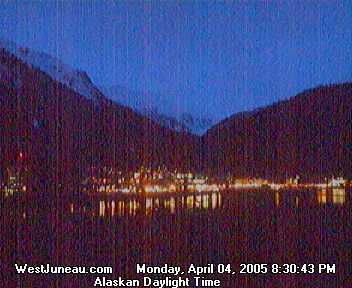
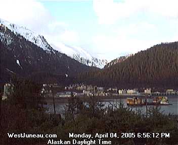
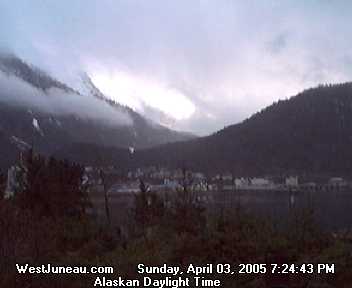