CONDITIONS DAY of Month: 1 2 3 4 5 6 7 8 9 10 11 12 13 14 15 16 17 18 19 20 21 22 23 24 25 26 27 28 29 30
NAME: 3270 Nowell   CITY: West Juneau   STATE: Alaska
ELEV:    97 ft  LAT: 58° 17' 33" N  LONG: 134° 25' 37" W


TEMPERATURE (°F), RAIN  (in), WIND SPEED (mph), SNOW (in). Snowfall from 21:00 - 21:00, all others Midnight to Midnight.

                                      HEAT  COOL        AVG                      WIND       SNOW
    MEAN                              DEG   DEG         WIND                DOM  RUN        ON(1)
DAY TEMP  HIGH   TIME   LOW    TIME   DAYS  DAYS  RAIN  SPEED HIGH   TIME   DIR  (mi)  SNOW GRND WEATHER
-----------------------------------------------------------------------------------------------------------------------------------------------------
 1  52.4  62.7   3:35p  42.9   3:30a  12.6   0.0  0.00   2.1  16.0  11:45a    W  51.33  0.0  0.0 MCd-BitofFog M/PCd P/MCd PCd Lt-Brz MClr PCd MCd PCd
 2  52.4  62.1   3:25p  42.9   5:50a  12.6   0.0  0.00   1.1  13.0  10:30a   NW  26.52  0.0  0.0 PCld Cld/MCld Fog PCld Clr MClr PCd MCld Ovcst-Cld
 3  51.7  56.7   5:50p  49.4   6:00a  13.3   0.0  0.09   0.1   9.0   2:35p  SSE   3.53  0.0  0.0 Cld Cld/Spr-VryLtRn-Rn Cd PCd MCd Cd/HntsBrks-SmBrks
 4  51.9  56.9  11:00a  48.2   9:55p  13.1   0.0  0.09   0.2   8.0  11:05p    W   4.48  0.0  0.0 Ovcst-Cd Ovcst/Shr TnyBrks Cd/Spr-RnShrs DecrCds Clr
 5  59.9  71.3   6:00p  46.4   2:50a   7.3   2.2  0.00   2.7  23.0   1:00p    E  65.34  0.0  0.0 IncrCds Cd FogBand Ovcst-Cd Lt-Brz PCd MOvcst Cd PCd
 6  56.4  68.1  12:35a  50.8  11:35p   8.7   0.1  0.02   1.0  23.0  12:45a  SSE  22.89  0.0  0.0 Cd Cd/VryLt:Spr-Rn-Mst Cd Slt-PBrknArea Cd/SmTnyBrks
 7  53.1  55.9   4:25p  51.3  12:05a  11.9   0.0  0.00   0.3   9.0   4:00p    E   6.00  0.0  0.0 Cldy FewSmall-TnyBrksat1650&1750 PrecipPartsofMnlnd
 8  52.5  56.6  10:05a  49.8  11:30p  12.5   0.0  0.03   0.4  10.0   4:35a  SSE   8.67  0.0  0.0 Cld Sm-TnyBrks-FiltBlu Cd/OccSpr-VryLtRn-Drz Cd/LtRn
 9  51.5  53.5  10:40p  49.5   5:15a  13.5   0.0  0.30   0.5  13.0   8:40p  SSE  11.53  0.0  0.0 Cld Cld/OccLtRn Cld/VryLtRn-Spr-Rn-LtRn-LtMist Cld
10  53.4  55.9   5:45p  50.2  12:00p  11.6   0.0  0.53   3.1  22.0   4:10p  SSE  74.51  0.0  0.0 Cld/Shrs Cld/Spr-Rn-VryLtRn-Driz Lt-Brzy-Gusts Cld
11  52.3  56.5   3:15p  44.8  12:00m  12.7   0.0  0.22   2.0  16.0  12:25p  SSE  48.77  0.0  0.0 Cd HvyShr Cd/Drz-Sp-Rn-LtRn VarPCd-MCd/FewSp PCd Clr
12  47.4  51.7  11:05a  43.9   1:05a  17.6   0.0  0.67   0.8  15.0   1:45p   NW  19.23  0.0  0.0 Ovcst-Cd MOvcst PCd Lt-Brz Cd/Spr-Rain Cd/Shrs Cd/Rn
13  49.1  53.6   3:50p  42.9  12:00m  15.9   0.0  0.11   0.6  11.0   6:00a  SSE  15.03  0.0  0.0 Cld/Shrs Cld/VryLtRn-SprWithLulls Cld Brks P/MCd PCd
14  48.1  58.3   2:10p  41.2   2:40a  16.9   0.0  0.00   0.3   9.0   9:15a   NW   6.46  0.0  0.0 DecrCds FogOvhd DecrFog Clr MClr PCd P/MCd PCd Clr
15  49.2  54.7  12:50p  42.3   1:25a  15.8   0.0  0.02   0.5  11.0  12:10p  WSW  12.77  0.0  0.0 PCd MCd Cd-TnyBrks PCd Cd Cd/VryLtRn-Spr Cd Cd/OccSp
16  52.5  56.6  11:40a  50.1  11:30p  12.5   0.0  0.35   0.8  14.0   5:55p  SSE  19.25  0.0  0.0 Cd/FewLtShrs Cd/VryLtRn-Spr-Rn Cd/Shrs Cd-Brks Cd/Rn
17  50.5  53.1   3:10p  48.3   3:05a  14.5   0.0  0.27   1.2  15.0   5:50a  SSE  29.44  0.0  0.0 Cd/Rn-VryLtRn Cd/PeriodsRn-Lt-VryLtRn-Spr-VryLtDrz
18  50.6  54.8   3:30p  47.6   4:35a  14.4   0.0  0.12   0.9  14.0   8:30p  SSE  21.61  0.0  0.0 Cd/Rn-Mst MCd Cd/LtPrecip Brks P/MCd Cd ThnnshCds Cd
19  49.1  51.7   2:45p  47.0   7:40a  15.9   0.0  0.15   1.0  11.0   6:05a  SSE  24.23  0.0  0.0 Cd Cd/LtMst-Drz-Rn-VryLtRn-Spr Cd Cd/Lt:Mst-Sp-Drz-R
20  49.4  50.4   9:50a  48.9  10:35a  15.6   0.0  0.54   2.5  20.0  11:00a  SSE  59.24  0.0  0.0 FewLtShrs Cd/SprShrs-Rn-HvyR-LtR-Spr-Lulls Cd/Rn-LtR
21  49.2  53.1  12:35p  45.5  12:00m  15.8   0.0  0.37   1.2  11.0   8:10a  SSE  28.62  0.0  0.0 Cld/LtRn-Spr Cld SunTried Cd/LtMst-Spr-Rn-LtRn-HvyRn
22  46.7  48.6   1:00p  45.2   1:35a  18.3   0.0  0.57   0.2  10.0  10:55p  WNW   5.32  0.0  0.0 Cld/Rn-Driz-Spr Cld  Cld/Spr-Lt-VryLtRn-Rn-HvyRn Cld
23  49.0  52.5   2:30p  45.8   1:45a  16.0   0.0  0.80   0.4  14.0  10:20a  SSE   9.69  0.0  0.0 Cld Cld/VryLtRn-Rn-LtRn-HvyRn-Spr ShortLullat1505Hrs
24  48.0  49.8   6:25a  46.1   6:05p  17.0   0.0  0.31   2.1  17.0  11:50a  SSE  50.23  0.0  0.0 Cd/R Cd Cd/Sp-R-Drz Cd-FewBrks Cd/Sp-LtR-Drz-R LtWnd
25  48.3  51.1   1:35p  46.4   2:45a  16.7   0.0  0.54   2.2  17.0   6:05p  SSE  53.86  0.0  0.0 Cld/Rn-LtRn-Drz Cd/Spr-LtRn-RnShrs Cd/Rn Cd/Brks Shr
26  45.4  48.8   4:35p  43.5   8:45p  19.6   0.0  0.47   1.0  13.0  10:10a  SSE  23.82  0.0  0.0 Cd/Shrs Cd/Rn-LtR-Drz-Sp-HvyR Cd/Brks-ClrSpots&Areas
27  44.9  48.6   4:45p  40.5  11:20p  20.1   0.0  0.04   0.6   9.0   7:05a  SSE  14.68  0.0  0.0 Cd Cd/LtPrecip Cd Spr ThinningCds/RnShr Rnbow ThnCds
28  43.0  55.1   3:10p  34.9  11:25p  22.0   0.0  0.00   1.7  20.0   4:05p    W  39.52  0.0  0.0 Cld Cld-ThinnerAreasFiltBlu PCld P/MCld PCld Clear
29  41.4  54.4   2:45p  32.4   6:30a  23.6   0.0  0.01   0.8  14.0  10:50a    W  18.09  0.0  0.0 Clr Frost MClr PCld MOvcst Ovcst-Cld-Brks Cld Cld/Rn
30  43.2  44.5  12:15a  42.2   5:00a  21.8   0.0  1.03   1.5  13.0   7:40a  SSE  34.89  0.0  0.0 Cloudy/Rain-HvyRn-VryLtRn-LtRn-LtDriz
-----------------------------------------------------------------------------------------------------------------------------------------------------
    49.8  71.3     5    32.4    29   459.8   2.3  7.65   1.1  23.0     5    SSE 807.55  0.0

(1) As measured on Front Lawn
STATISTICS | DATA | GRAPHS | CONDITIONS - DAY of MONTH: 1 2 3 4 5 6 7 8 9 10 11 12 13 14 15
16 17 18 19 20 21 22 23 24 25 26 27 28 29 30 | TOP
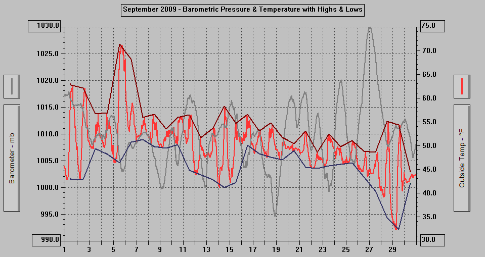
AVERAGE Mean Temp:	49.8
AVERAGE High Temp:	54.9
MINIMUM High Temp:	44.5	30th
MAXIMUM High Temp:	71.3	5th
AVERAGE Low Temp:	45.4
MINIMUM Low Temp:	32.4	29th
MAXIMUM Low Temp:	51.3	7th

MAX >= 90.0:		0
MAX >= 80.0:		0
MAX >= 70.0:		1	5th
MAX <= 32.0:		0
MIN <= 32.0:		0
MIN <=  0.0:		0

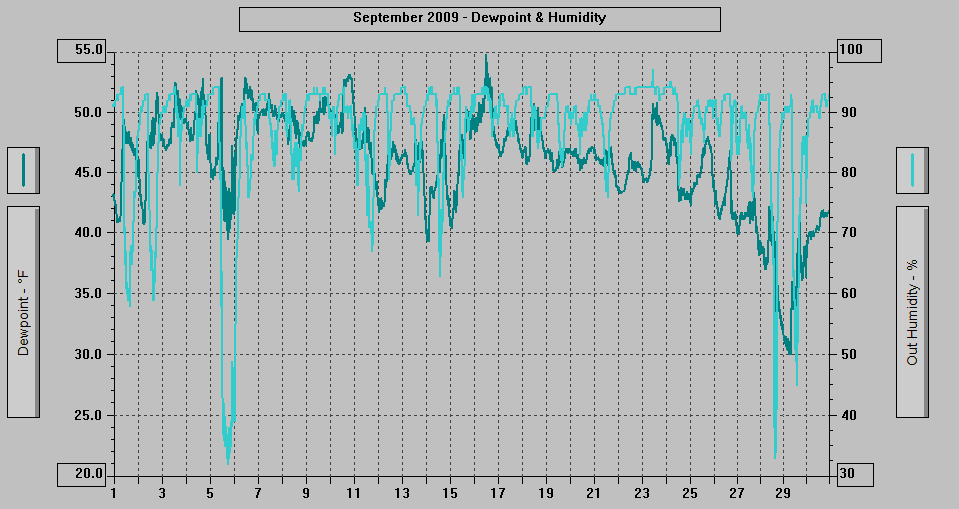
MAXIMUM Humidity (%):	97	23rd @ 1027
MINIMUM Humidity (%):	32	28th @ 1600

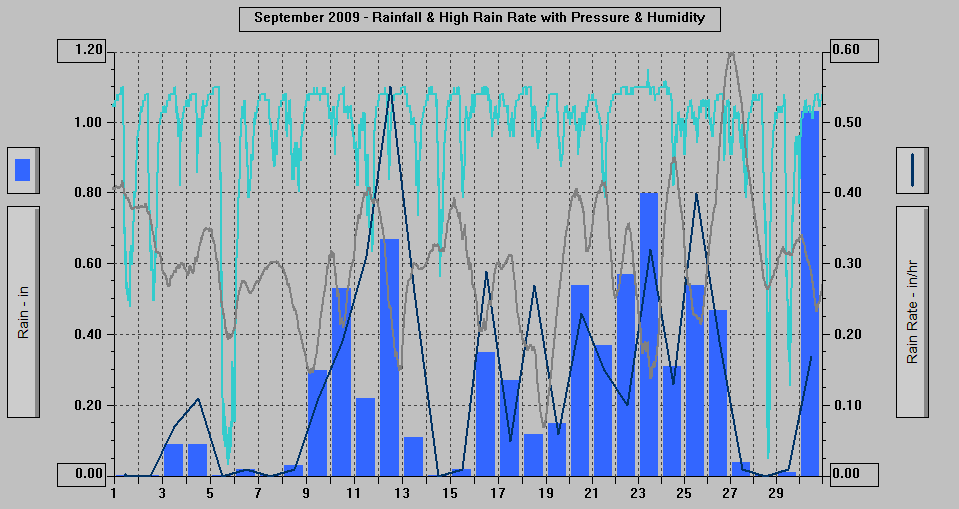
MAXIMUM Pressure (mb):	1029.9	27th @ 0144
MINIMUM Pressure (mb):	994.6	18th @ 2129

TOTAL   Htg Deg Days:	459.8
AVERAGE Htg Deg Days:	15.3
MINIMUM Htg Deg Days:	7.3	5th
MAXIMUM Htg Deg Days:	23.6	29th
TOTAL Cool Deg Days:	2.3
Heat Base:  65.0  Cool Base:  65.0  Method: Integration

TOTAL   Precip.:	7.65
AVERAGE Precip. A:	0.32	(Per day, for the 24 days with measurable precip.)
AVERAGE Precip. B:	0.26	(Per day)
DAYS of Precip.:	24	All but: 1st, 2nd, 5th, 7th, 14th, 28th
MAXIMUM Precip.:	1.03	30th
MAXIMUM Rain Rate:	0.55	12th @ 2239
Days of Rain: 23 (>.01 in) 17 (>.1 in) 1 (>1 in)
TOTAL Snowfall:		0.0
DAYS of Snowfall:	0

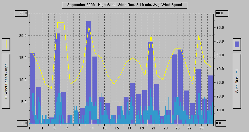
AVERAGE High Wind:	14.0
MINIMUM High Wind:	8	4th
MAXIMUM High Wind:	23	5th, 6th
WIND RUN (miles):	809.55


DAYS Full Sun any time:	14	1st, 2nd, 3rd, 5th, 11th, 13th, 14th, 15th, 16th, 18th, 24th, 27th, 28th, 29th

DAYS Full Sun any
time - Mainland Only:	3	4th, 6th, 26th

DAYS OF Extrm Wk To
Somewhat Weakened Sun:	2	7th (Mt. Roberts only), 8th

DAYS Sun Tried Briefly:	1	21st

DAYS With Cld or M Cld:	30	All days
DAYS OF Rainbow:	1	27th: Full Faint Rainbow to ENE at 1718 becoming partal by 1730. Faded out by 1736.
DAYS OF Aurora:		0
DAYS OF Lightning:	0
DAYS OF Earthquake:	0

WEAK51 PAAQ 300828
TSUAK1

BULLETIN
PUBLIC TSUNAMI MESSAGE NUMBER 9
NWS WEST COAST/ALASKA TSUNAMI WARNING CENTER PALMER AK
128 AM PDT WED SEP 30 2009

...THE TSUNAMI ADVISORY IS CANCELED FOR THE COASTAL AREAS
   OF CALIFORNIA AND OREGON FROM THE CALIFORNIA-MEXICO BORDER
   TO THE OREGON-WASHINGTON BORDER...

A DAMAGING TSUNAMI IS NOT EXPECTED ALONG THE COASTS OF THE U.S.
WEST COAST STATES - ALASKA AND BRITISH COLUMBIA. HOWEVER SOME OF
THESE AREAS MAY EXPERIENCE NON-DAMAGING SEA LEVEL CHANGES. AS
LOCAL CONDITIONS CAN CAUSE A WIDE VARIATION IN TSUNAMI IMPACT THE
ALL CLEAR DETERMINATIONS MUST BE MADE BY LOCAL AUTHORITIES.

A TSUNAMI HAS BEEN OBSERVED AT THE FOLLOWING SITES

 LOCATION                   LAT    LON     TIME        AMPL
 ------------------------  -----  ------  -------     -----------
 EASTER ISLAND  CHILE      27.1S  109.3W  0342UTC     0.25M/0.8FT
 CHARLESTON  OR            43.3N  124.3W  0528UTC     0.13M/0.4FT
 PORT ORFORD  OR           42.7N  124.5W  0509UTC     0.17M/0.6FT
 SOUTH BEACH  OR           44.6N  124.0W  0545UTC     0.09M/0.3FT
 SHEMYA  AK                52.7N  174.1E  0456UTC     0.10M/0.3FT
 CRESCENT CITY  CA         41.7N  124.2W  0613UTC     0.21M/0.7FT
 ARENA COVE  CA            38.9N  123.7W  0459UTC     0.33M/1.1FT
 PORT SAN LUIS  CA         35.2N  120.8W  0531UTC     0.30M/1.0FT
 SAN FRANSICO  CA          37.8N  122.5W  0529UTC     0.08M/0.3FT
 MONTEREY HARBOR  CA       36.6N  121.9W  0525UTC     0.15M/0.5FT

TIME - TIME OF MEASUREMENT
AMPL - TSUNAMI AMPLITUDES ARE MEASURED RELATIVE TO NORMAL SEA LEVEL.
       IT IS ...NOT... CREST-TO-TROUGH WAVE HEIGHT.
       VALUES ARE GIVEN IN BOTH METERS(M) AND FEET(FT).

AT 1048 AM PACIFIC DAYLIGHT TIME ON SEPTEMBER 29 AN EARTHQUAKE WITH
PRELIMINARY MAGNITUDE 8.0 OCCURRED
IN THE SAMOA ISLANDS REGION.

THIS WILL BE THE LAST WEST COAST/ALASKA TSUNAMI
WARNING CENTER MESSAGE ISSUED FOR THIS EVENT.

TO REPEAT - NO TSUNAMI WARNING... NO WATCH AND NO ADVISORY IS IN
EFFECT FOR THE U.S. WEST COAST STATES - ALASKA AND BRITISH COLUMBIA.
SEE THE WEB SITE WCATWC.ARH.NOAA.GOV FOR BASIC TSUNAMI
INFORMATION... SAFETY RULES AND TSUNAMI TRAVEL TIMES.

$$
WEAK51 PAAQ 300224
TSUAK1

BULLETIN
PUBLIC TSUNAMI MESSAGE NUMBER 6
NWS WEST COAST/ALASKA TSUNAMI WARNING CENTER PALMER AK
724 PM PDT TUE SEP 29 2009

...A TSUNAMI ADVISORY IS IN EFFECT WHICH INCLUDES THE
   COASTAL AREAS OF CALIFORNIA AND OREGON FROM THE
   CALIFORNIA-MEXICO BORDER TO THE OREGON-WASHINGTON BORDER...

...THIS MESSAGE IS INFORMATION ONLY FOR COASTAL AREAS OF
   WASHINGTON - BRITISH COLUMBIA AND ALASKA FROM THE
   OREGON-WASHINGTON BORDER TO ATTU ALASKA...

A TSUNAMI ADVISORY MEANS THAT A TSUNAMI CAPABLE OF PRODUCING
STRONG CURRENTS OR WAVES DANGEROUS TO PERSONS IN OR VERY NEAR
THE WATER IS IMMINENT OR EXPECTED.  SIGNIFICANT WIDESPREAD
INUNDATION IS NOT EXPECTED FOR AREAS UNDER AN ADVISORY.
CURRENTS MAY BE HAZARDOUS TO SWIMMERS... BOATS... AND COASTAL
STRUCTURES AND MAY CONTINUE FOR SEVERAL HOURS AFTER THE
INITIAL WAVE ARRIVAL.

AT 1048 AM PACIFIC DAYLIGHT TIME ON SEPTEMBER 29 AN EARTHQUAKE WITH
PRELIMINARY MAGNITUDE 8.0 OCCURRED
IN THE SAMOA ISLANDS REGION.
THIS EARTHQUAKE HAS GENERATED A TSUNAMI WHICH COULD CAUSE DAMAGE
TO REGIONS IN A WARNING OR ADVISORY.
ESTIMATED TSUNAMI ARRIVAL TIMES AND MAPS ALONG WITH SAFETY RULES
AND OTHER INFORMATION CAN BE FOUND ON THE WEB SITE
WCATWC.ARH.NOAA.GOV.

A TSUNAMI HAS BEEN OBSERVED AT THE FOLLOWING SITES

 LOCATION                   LAT    LON     TIME        AMPL
 ------------------------  -----  ------  -------     -----------
 APIA  WEST SAMOA          13.8S  171.8W  1829UTC     0.70M/2.3FT
 PAGO PAGO  AMER. SAMOA    14.3S  170.7W  1825UTC     1.57M/5.1FT
 RAROTONGA  COOK IS. (NZ   21.2S  159.8E  1950UTC     0.54M/1.8FT
 PAPEETE  FR. POLYNESIA    17.5S  149.6W  2137UTC     0.14M/0.5FT
 PORT VILA  VANUATU        17.8S  168.3E  2239UTC     0.18M/0.6FT
 NAWILIWILI KAUAI  HI      22.0N  159.4W  0015UTC     0.20M/0.7FT
 KAWAIHAE  HI              20.0N  155.8W  0009UTC     0.14M/0.7FT
 HONOLULU OAHU  HI         21.3N  157.9W  0031UTC     0.16M/0.5FT
 KAHULUI MAUI  HI          20.9N  156.5W  0113UTC     0.36M/1.2FT
 THE PEAK TSUNAMI AMPLITUDES HAVE PASSED IN HAWAII.  THE MAXIMUM
 AMPLITUDE WAS RECORDED AT THE TIDE GAGE IN KAHULUI.  OBSERVATIONS
 IN HAWAII SUPPORT FORECASTS OF 10 TO 60CM ALONG THE CALIFORNIA
 AND OREGON COASTS. TSUNAMIS OF 50CM AMPLITUDE CAN GENERATE STRONG
 CURRENTS DANGEROUS TO THOSE VERY NEAR OR IN THE OCEAN.  THE
 TSUNAMI IS EXPECTED TO BUILD AND REACH ITS MAXIMUM APPROXIMATELY
 ONE AND A HALF HOURS AFTER THE INITIAL ARRIVAL.  TSUNAMI
 ARRIVAL TIMES AND OTHER AMPLITUDE FORECASTS ARE LISTED IN
 THE WEB SITE BELOW.

TIME - TIME OF MEASUREMENT
AMPL - TSUNAMI AMPLITUDES ARE MEASURED RELATIVE TO NORMAL SEA LEVEL.
       IT IS ...NOT... CREST-TO-TROUGH WAVE HEIGHT.
       VALUES ARE GIVEN IN BOTH METERS(M) AND FEET(FT).

TSUNAMIS CAN BE DANGEROUS WAVES THAT ARE NOT SURVIVABLE. WAVE
HEIGHTS ARE AMPLIFIED BY IRREGULAR SHORELINE AND ARE DIFFICULT TO
FORECAST. TSUNAMIS OFTEN APPEAR AS A STRONG SURGE AND MAY BE
PRECEDED BY A RECEDING WATER LEVEL.  MARINERS IN WATER DEEPER
THAN 600 FEET SHOULD NOT BE AFFECTED BY A TSUNAMI. WAVE HEIGHTS
WILL INCREASE RAPIDLY AS WATER SHALLOWS. TSUNAMIS ARE A SERIES OF
OCEAN WAVES WHICH CAN BE DANGEROUS FOR SEVERAL HOURS AFTER THE
INITIAL WAVE ARRIVAL. DO NOT RETURN TO EVACUATED AREAS UNTIL AN
ALL CLEAR IS GIVEN BY LOCAL CIVIL AUTHORITIES.

THIS MESSAGE WILL BE UPDATED IN 120 MINUTES OR SOONER IF
THE SITUATION WARRANTS. THE TSUNAMI MESSAGE WILL REMAIN
IN EFFECT UNTIL FURTHER NOTICE. FOR FURTHER INFORMATION STAY TUNED
TO NOAA WEATHER RADIO... YOUR LOCAL TV OR RADIO STATIONS... OR SEE
THE WEB SITE WCATWC.ARH.NOAA.GOV.

$$
The following list gives estimated times of arrival for
locations along the North American Pacific coast from a
tsunami generated at the given source location.  The
list is ordered by arrival time starting with the earliest.
Since tsunami speed is directly related to
water depth, tsunami ETAs can be computed independent of
tsunami amplitude.  THE LISTING OF A TSUNAMI ARRIVAL TIME
BELOW DOES NOT INDICATE A WAVE IS IMMINENT. The listed arrival
time is the initial wave arrival.  Tsunamis can be dangerous
for many hours after arrival, and the initial wave is not
necessarily the largest.

Source:
Lat:     15.3S
Lng:     171.0W
Mag:    8.0
O-time: 1748UTC
Date:   SEP 29

Estimated times of initial tsunami arrival:

DART 46413                                      1835 AKDT SEP 29    0235 UTC SEP 30
DART 46408                                      1842 AKDT SEP 29    0242 UTC SEP 30
DART 21414                                      1843 AKDT SEP 29    0243 UTC SEP 30
DART 46402                                      1859 AKDT SEP 29    0259 UTC SEP 30
DART 21415                                      1902 AKDT SEP 29    0302 UTC SEP 30
Amchitka, Alaska                                1907 AKDT SEP 29    0307 UTC SEP 30
Atka, Alaska                                    1913 AKDT SEP 29    0313 UTC SEP 30
DART 46403                                      1919 AKDT SEP 29    0319 UTC SEP 30
DART 46412                                      2022  PDT SEP 29    0322 UTC SEP 30
DART 46411                                      2024  PDT SEP 29    0324 UTC SEP 30
Adak, Alaska                                    1925 AKDT SEP 29    0325 UTC SEP 30
DART 46407                                      2035  PDT SEP 29    0335 UTC SEP 30
Shemya, Alaska                                  1939 AKDT SEP 29    0339 UTC SEP 30
Nikolski, Alaska                                1940 AKDT SEP 29    0340 UTC SEP 30
Attu, Alaska                                    1943 AKDT SEP 29    0343 UTC SEP 30
Point Concepcion, California                    2045  PDT SEP 29    0345 UTC SEP 30
Point Sur, California                           2045  PDT SEP 29    0345 UTC SEP 30
Point Arena, California                         2053  PDT SEP 29    0353 UTC SEP 30
Monterey, California                            2053  PDT SEP 29    0353 UTC SEP 30
Fort Bragg, California                          2053  PDT SEP 29    0353 UTC SEP 30
DART 46409                                      1955 AKDT SEP 29    0355 UTC SEP 30
Point Reyes, California                         2057  PDT SEP 29    0357 UTC SEP 30
Port San Luis, California                       2058  PDT SEP 29    0358 UTC SEP 30
DART 46404                                      2058  PDT SEP 29    0358 UTC SEP 30
Akutan, Alaska                                  1958 AKDT SEP 29    0358 UTC SEP 30
Cape Mendocino, California                      2059  PDT SEP 29    0359 UTC SEP 30
Santa Barbara, California                       2103  PDT SEP 29    0403 UTC SEP 30
San Pedro, California                           2106  PDT SEP 29    0406 UTC SEP 30
Humboldt Bay, California                        2106  PDT SEP 29    0406 UTC SEP 30
La Jolla, California                            2107  PDT SEP 29    0407 UTC SEP 30
Newport Beach, California                       2110  PDT SEP 29    0410 UTC SEP 30
Dutch Harbor, Alaska                            2010 AKDT SEP 29    0410 UTC SEP 30
Santa Monica, California                        2111  PDT SEP 29    0411 UTC SEP 30
the California-Mexico border                    2111  PDT SEP 29    0411 UTC SEP 30
DART 46419                                      2113  PDT SEP 29    0413 UTC SEP 30
Crescent City, California                       2116  PDT SEP 29    0416 UTC SEP 30
Cape Blanco, Oregon                             2118  PDT SEP 29    0418 UTC SEP 30
the Oregon-California border                    2120  PDT SEP 29    0420 UTC SEP 30
DART 46410                                      2024 AKDT SEP 29    0424 UTC SEP 30
San Francisco, California                       2125  PDT SEP 29    0425 UTC SEP 30
Charleston, Oregon                              2128  PDT SEP 29    0428 UTC SEP 30
King Cove, Alaska                               2029 AKDT SEP 29    0429 UTC SEP 30
Sand Point, Alaska                              2029 AKDT SEP 29    0429 UTC SEP 30
Cascade Head, Oregon                            2143  PDT SEP 29    0443 UTC SEP 30
Perryville, Alaska                              2045 AKDT SEP 29    0445 UTC SEP 30
Newport, Oregon                                 2148  PDT SEP 29    0448 UTC SEP 30
the north tip of Vancouver Island, British Columbia 2148  PDT SEP 29    0448 UTC SEP 30
Tillamook Bay, Oregon                           2150  PDT SEP 29    0450 UTC SEP 30
Langara Island, British Columbia                2150  PDT SEP 29    0450 UTC SEP 30
the Oregon-Washington border                    2152  PDT SEP 29    0452 UTC SEP 30
St. Paul, Alaska                                2057 AKDT SEP 29    0457 UTC SEP 30
Seaside, Oregon                                 2201  PDT SEP 29    0501 UTC SEP 30
La Push, Washington                             2202  PDT SEP 29    0502 UTC SEP 30
the Washington-British Columbia border          2203  PDT SEP 29    0503 UTC SEP 30
Cold Bay, Alaska                                2104 AKDT SEP 29    0504 UTC SEP 30
Port Alexander, Alaska                          2104 AKDT SEP 29    0504 UTC SEP 30
Point Grenville, Washington                     2205  PDT SEP 29    0505 UTC SEP 30
Kodiak, Alaska                                  2108 AKDT SEP 29    0508 UTC SEP 30
Westport, Washington                            2208  PDT SEP 29    0508 UTC SEP 30
Tofino, British Columbia                        2208  PDT SEP 29    0508 UTC SEP 30
Neah Bay, Washington                            2209  PDT SEP 29    0509 UTC SEP 30
Old Harbor, Alaska                              2111 AKDT SEP 29    0511 UTC SEP 30
Sitka, Alaska                                   2111 AKDT SEP 29    0511 UTC SEP 30
Elfin Cove, Alaska                              2112 AKDT SEP 29    0512 UTC SEP 30
Astoria, Oregon                                 2224  PDT SEP 29    0524 UTC SEP 30
Seward, Alaska                                  2130 AKDT SEP 29    0530 UTC SEP 30
Yakutat, Alaska                                 2135 AKDT SEP 29    0535 UTC SEP 30
Alitak, Alaska                                  2136 AKDT SEP 29    0536 UTC SEP 30
Port Angeles, Washington                        2247  PDT SEP 29    0547 UTC SEP 30
Ketchikan, Alaska                               2148 AKDT SEP 29    0548 UTC SEP 30
Valdez, Alaska                                  2150 AKDT SEP 29    0550 UTC SEP 30
Craig, Alaska                                   2154 AKDT SEP 29    0554 UTC SEP 30
Cordova, Alaska                                 2200 AKDT SEP 29    0600 UTC SEP 30
Prince Rupert, British Columbia                 2319  PDT SEP 29    0619 UTC SEP 30
Homer, Alaska                                   2224 AKDT SEP 29    0624 UTC SEP 30
Juneau, Alaska                                  2225 AKDT SEP 29    0625 UTC SEP 30
Seattle, Washington                             2342  PDT SEP 29    0642 UTC SEP 30
Bella Bella, British Columbia                   2346  PDT SEP 29    0646 UTC SEP 30
Saint Matthew Island, Alaska                    2325 AKDT SEP 29    0725 UTC SEP 30
Port Moller, Alaska                             2350 AKDT SEP 29    0750 UTC SEP 30
Cape Newenham, Alaska                           0124 AKDT SEP 30    0924 UTC SEP 30
Gambell, Alaska                                 0130 AKDT SEP 30    0930 UTC SEP 30
Dillingham, Alaska                              0314 AKDT SEP 30    1114 UTC SEP 30
Hooper Bay, Alaska                              0346 AKDT SEP 30    1146 UTC SEP 30
Little Diomede Island, Alaska                   0427 AKDT SEP 30    1227 UTC SEP 30
Nome, Alaska                                    0623 AKDT SEP 30    1423 UTC SEP 30
Unalakleet, Alaska                              0926 AKDT SEP 30    1726 UTC SEP 30
No. 3 WEAK51 PAAQ 292202;  No. 4 WEAK51 PAAQ 292314;  No. 5 WEAK51 PAAQ 300021
TSUAK1

BULLETIN
PUBLIC TSUNAMI MESSAGE NUMBER 3 (with Updates from No. 4 Issued 414 PM and No. 5 5:21 PM Inserted)
NWS WEST COAST/ALASKA TSUNAMI WARNING CENTER PALMER AK
302 PM PDT TUE SEP 29 2009

...A TSUNAMI ADVISORY IS IN EFFECT WHICH INCLUDES THE
   COASTAL AREAS OF CALIFORNIA AND OREGON FROM THE
   CALIFORNIA-MEXICO BORDER TO THE OREGON-WASHINGTON BORDER...

...THIS MESSAGE IS INFORMATION ONLY FOR COASTAL AREAS OF
   WASHINGTON - BRITISH COLUMBIA AND ALASKA FROM THE
   OREGON-WASHINGTON BORDER TO ATTU ALASKA...

A TSUNAMI ADVISORY MEANS THAT A TSUNAMI CAPABLE OF PRODUCING
STRONG CURRENTS OR WAVES DANGEROUS TO PERSONS IN OR VERY NEAR
THE WATER IS IMMINENT OR EXPECTED.  SIGNIFICANT WIDESPREAD
INUNDATION IS NOT EXPECTED FOR AREAS UNDER AN ADVISORY.
CURRENTS MAY BE HAZARDOUS TO SWIMMERS... BOATS... AND COASTAL
STRUCTURES AND MAY CONTINUE FOR SEVERAL HOURS AFTER THE
INITIAL WAVE ARRIVAL.

AT 1048 AM PACIFIC DAYLIGHT TIME ON SEPTEMBER 29 AN EARTHQUAKE WITH
PRELIMINARY MAGNITUDE 8.0 OCCURRED
IN THE SAMOA ISLANDS REGION.
THIS EARTHQUAKE HAS GENERATED A TSUNAMI WHICH COULD CAUSE DAMAGE
TO REGIONS IN A WARNING OR ADVISORY.
ESTIMATED TSUNAMI ARRIVAL TIMES AND MAPS ALONG WITH SAFETY RULES
AND OTHER INFORMATION CAN BE FOUND ON THE WEB SITE
WCATWC.ARH.NOAA.GOV.

A TSUNAMI HAS BEEN OBSERVED AT THE FOLLOWING SITES
(Updated From Bulletin No. 4 Issued 414 PM &  No. 5 Issued 521 PM PDT TUE SEP 29 2009)

 LOCATION                   LAT    LON     TIME        AMPL
 ------------------------  -----  ------  -------     -----------
 APIA  WEST SAMOA          13.8S  171.8W  1832UTC     0.70M/2.3FT
 PAGO PAGO  AMER. SAMOA    14.3S  170.7W  1825UTC     1.57M/5.1FT
 RAROTONGA  COOK IS. (NZ   21.2S  159.8E  1950UTC     0.54M/1.8FT
 LAUTOKA  FIJI             17.6S  177.4E  2136UTC     0.05M/0.2FT
 OWENGA  CHATHAM  NZ       44.0S  176.4W  2248UTC     0.08M/0.3FT
 PAPEETE  FR. POLYNESIA    17.5S  149.6W  2137UTC     0.14M/0.5FT
 PENRHYN  COOK IS. NZ       9.0S  158.0W  2103UTC     0.08M/0.3FT
 PORT VILA  VANUATU        17.8S  168.3E  2239UTC     0.18M/0.6FT
 NAWILIWILI KAUAI  HI      22.0N  159.4W  0011UTC     0.16M/0.5FT
 KAWAIHAE  HI              20.0N  155.8W  0013UTC     0.18M/0.6FT
 FORECASTS INDICATE THAT A TSUNAMI WITH AMPLITUDES IN THE RANGE
 OF 20 TO 65CM IS EXPECTED ALONG THE CALIFORNIA AND OREGON COAST.
 TSUNAMIS OF THIS AMPLITUDE CAN GENERATE STRONG CURRENTS DANGEROUS
 TO THOSE VERY NEAR OR IN THE OCEAN.  THE TSUNAMI IS EXPECTED TO
 BUILD AND REACH ITS MAXIMUM APPROXIMATELY ONE AND A HALF HOURS
 AFTER THE INITIAL ARRIVAL.  FURTHER ARRIVAL TIMES AND OTHER
 INFORMATION IS LISTED IN THE WEB SITE BELOW.

TIME - TIME OF MEASUREMENT
AMPL - TSUNAMI AMPLITUDES ARE MEASURED RELATIVE TO NORMAL SEA LEVEL.
       IT IS ...NOT... CREST-TO-TROUGH WAVE HEIGHT.
       VALUES ARE GIVEN IN BOTH METERS(M) AND FEET(FT).

TSUNAMIS CAN BE DANGEROUS WAVES THAT ARE NOT SURVIVABLE. WAVE
HEIGHTS ARE AMPLIFIED BY IRREGULAR SHORELINE AND ARE DIFFICULT TO
FORECAST. TSUNAMIS OFTEN APPEAR AS A STRONG SURGE AND MAY BE
PRECEDED BY A RECEDING WATER LEVEL.  MARINERS IN WATER DEEPER
THAN 600 FEET SHOULD NOT BE AFFECTED BY A TSUNAMI. WAVE HEIGHTS
WILL INCREASE RAPIDLY AS WATER SHALLOWS. TSUNAMIS ARE A SERIES OF
OCEAN WAVES WHICH CAN BE DANGEROUS FOR SEVERAL HOURS AFTER THE
INITIAL WAVE ARRIVAL. DO NOT RETURN TO EVACUATED AREAS UNTIL AN
ALL CLEAR IS GIVEN BY LOCAL CIVIL AUTHORITIES.

THE PACIFIC TSUNAMI WARNING CENTER IN EWA BEACH HAWAII HAS
CANCELLED THE WARNING FOR COUNTRIES IN THE SAMOA REGION.

BULLETIN No. 5 Issued 521 PM PDT WILL BE UPDATED IN 120 MINUTES OR SOONER IF
THE SITUATION WARRANTS. THE TSUNAMI MESSAGE WILL REMAIN
IN EFFECT UNTIL FURTHER NOTICE. FOR FURTHER INFORMATION STAY TUNED
TO NOAA WEATHER RADIO... YOUR LOCAL TV OR RADIO STATIONS... OR SEE
THE WEB SITE WCATWC.ARH.NOAA.GOV.

$$
Freeze Warning
Statement as of 4:25 AM AKDT on September 29, 2009

...Freeze warning remains in effect until 9 am akdt this
morning...

A freeze warning remains in effect until 9 am akdt this morning.

Clear skies have brought colder temperatures and areas of frost to
the Juneau Borough and northern Panhandle tonight. Many
locations...especially the Mendenhall Valley...will remain at or
below freezing before warming through the morning.

The average day of the first frost at the Juneau International
Airport is September 29th. The average day of the first low of
28 degrees or colder...a killing frost...is October 14th.

Precautionary/preparedness actions...

A warning means that a hard freeze is already occurring or
imminent.

A hard freeze in Southeast Alaska is defined as freezing
temperatures lasting six hours or longer...or temperatures
falling to 28 degrees.

Plants subject to damage from frost or subfreezing temperatures
should be given the appropriate protection.

This statement will be updated by 9 am akdt Tuesday or sooner if
conditions warrant.
NWS Frost Advisory
Statement as of 4:53 AM AKDT on September 28, 2009

...Frost advisory in effect from midnight tonight to 9 am akdt
Tuesday...

The National Weather Service in Juneau has issued a frost
advisory...which is in effect from midnight tonight to 9 am akdt
Tuesday.

Clear skies will bring colder temperatures and areas of frost to
the northern Panhandle tonight. Many locations...especially those
inland and in low lying valleys...are expected to see low
temperatures in the lower 30s tonight.

The average day of the first frost at the Juneau International
Airport is September 29th. The average day of the first low of
28 degrees or colder...a killing frost...is October 14th.

Precautionary/preparedness actions...

Frost advisories are issued during the growing season so that
sensitive plants can be covered or brought inside before damage
occurs.

Plants subject to damage from frost should be given the
appropriate protection.

This statement will be updated by 4 PM akdt or sooner if
conditions warrant.
NWS Special Weather Statement
Statement as of 4:30 AM AKDT on September 27, 2009

...First frost of the season in many locations in the central Panhandle
Monday night into Tuesday morning...

With clear skies and cold air moving over the area from the Yukon expect
temperatures to drop to near freezing along and north of Icy
Strait Monday night through Tuesday morning...especially in wind
sheltered locations.

Plants subject to damage from frost should be given the
appropriate protection.

Sensitive plants and shrubs should be covered or brought indoors
if possible Monday night.

Please stay tuned to NOAA Weather Radio or your favorite local
weather news source for updates on this situation.


Pss
NWS Wind Advisory
Statement as of 5:33 PM AKDT on September 24, 2009

...Wind Advisory in effect until 6 am akdt Friday...

The National Weather Service in Juneau has issued a Wind
Advisory...which is in effect until 6 am akdt Friday.

A strong front will move over the Southeast Alaska Thursday
evening. Strong winds from the southeast to 25 mph with gusts to 45
mph in exposed areas will continue through the overnight hours.

Precautionary/preparedness actions...

A Wind Advisory means that sustained wind speed or frequent gusts
will occur between 40 and 60 mph.

This statement will be updated by 1000 PM akdt Thursday or sooner
if conditions warrant.
WWAK77PAJK_AKZ025
-----------------
AKZ021-025-110215-
/X.CON.PAJK.WI.Y.0055.000000T0000Z-090911T0500Z/
EASTERN CHICHAGOF ISLAND-
JUNEAU BOROUGH AND NORTHERN ADMIRALTY ISLAND-
INCLUDING THE CITIES OF...HOONAH...JUNEAU
1138 AM AKDT THU SEP 10 2009

...WIND ADVISORY REMAINS IN EFFECT UNTIL 9 PM AKDT THIS EVENING...

A WIND ADVISORY REMAINS IN EFFECT UNTIL 9 PM AKDT THIS EVENING.

WINDS UP TO 30 MPH WITH GUSTS TO 40 MPH WILL CONTINUE THROUGH
EARLY EVENING.

PRECAUTIONARY/PREPAREDNESS ACTIONS...

A WIND ADVISORY MEANS THAT SUSTAINED WIND SPEED OR FREQUENT GUSTS
WILL OCCUR BETWEEN 40 AND 60 MPH.

THIS STATEMENT WILL BE UPDATED BY 6 PM AKDT T0DAY OR SOONER IF
CONDITIONS WARRANT.

&&

$$
FPAK77PAJK_AKZ025
WWAK77PAJK_AKZ025
-----------------
AKZ025-102015-
/X.EXT.PAJK.WI.Y.0055.090910T1700Z-090911T0500Z/
JUNEAU BOROUGH AND NORTHERN ADMIRALTY ISLAND-
INCLUDING THE CITY OF...JUNEAU
448 AM AKDT THU SEP 10 2009

...WIND ADVISORY NOW IN EFFECT FROM 9 AM THIS MORNING TO 9 PM
AKDT THIS EVENING...

THE WIND ADVISORY IS NOW IN EFFECT FROM 9 AM THIS MORNING TO 9 PM
AKDT THIS EVENING.

WINDS WILL INCREASE TO 30 MPH WITH GUSTS TO 40 MPH BY LATE THIS MORNING
AND CONTINUE THROUGH EARLY EVENING.

PRECAUTIONARY/PREPAREDNESS ACTIONS...

A WIND ADVISORY MEANS THAT SUSTAINED WIND SPEED OR FREQUENT GUSTS
WILL OCCUR BETWEEN 40 AND 60 MPH.

THIS STATEMENT WILL BE UPDATED BY NOON AKDT T0DAY OR SOONER IF
CONDITIONS WARRANT.

&&

$$
FPAK77PAJK_AKZ025
WWAK77PAJK_AKZ025
-----------------
AKZ020-025-100815-
/X.CON.PAJK.WI.Y.0055.090910T2000Z-090911T0500Z/
GLACIER BAY-JUNEAU BOROUGH AND NORTHERN ADMIRALTY ISLAND-
INCLUDING THE CITIES OF...GUSTAVUS...JUNEAU
338 PM AKDT WED SEP 9 2009

...WIND ADVISORY REMAINS IN EFFECT FROM NOON TO 9 PM AKDT
THURSDAY...

A WIND ADVISORY REMAINS IN EFFECT FROM NOON TO 9 PM AKDT
THURSDAY.

WINDS WILL INCREASE TO 30 MPH WITH GUSTS TO 40 MPH BY MIDDAY
THURSDAY...AND CONTINUE THROUGH EARLY THURSDAY EVENING.

PRECAUTIONARY/PREPAREDNESS ACTIONS...

A WIND ADVISORY MEANS THAT SUSTAINED WIND SPEED OR FREQUENT GUSTS
WILL OCCUR BETWEEN 40 AND 60 MPH.

THIS STATEMENT WILL BE UPDATED BY MIDNIGHT AKDT TONIGHT OR SOONER
IF CONDITIONS WARRANT.

&&

$$
FPAK77PAJK_AKZ025
WWAK77PAJK_AKZ025
-----------------
AKZ020-025-100015-
/X.NEW.PAJK.WI.Y.0055.090910T2000Z-090911T0500Z/
GLACIER BAY-JUNEAU BOROUGH AND NORTHERN ADMIRALTY ISLAND-
INCLUDING THE CITIES OF...GUSTAVUS...JUNEAU
450 AM AKDT WED SEP 9 2009

...WIND ADVISORY IN EFFECT FROM NOON TO 9 PM AKDT THURSDAY...

THE NATIONAL WEATHER SERVICE IN JUNEAU HAS ISSUED A WIND
ADVISORY...WHICH IS IN EFFECT FROM NOON TO 9 PM AKDT THURSDAY.

WINDS WILL INCREASE TO 30 MPH WITH GUSTS TO 40 MPH BY MIDDAY
THURSDAY...AND CONTINUE THROUGH EARLY THURSDAY EVENING.

PRECAUTIONARY/PREPAREDNESS ACTIONS...

A WIND ADVISORY MEANS THAT SUSTAINED WIND SPEED OR FREQUENT GUSTS
WILL OCCUR BETWEEN 40 AND 60 MPH.

THIS STATEMENT WILL BE UPDATED BY 4 PM AKDT THIS AFTERNOON OR SOONER
IF CONDITIONS WARRANT.

&&

$$
FPAK57PAJK_AKZ025
...A WETTER THAN NORMAL AUGUST...

AUGUST STARTED WITH NEAR NORMAL TEMPERATURES THAT RAPIDLY ROSE
ABOVE NORMAL FOR THE FIRST WEEK OF THE MONTH DUE TO A SUNNY
DRY SPELL. THE HIGH TEMPERATURE REACHED 80 DEGREES ON THE 5TH
...SETTING A NEW DAILY RECORD HIGH. BY THE 14TH...JUNEAU
TEMPERATURES FELL BELOW NORMAL AND REMAINED THAT WAY THROUGHOUT
THE REST OF THE MONTH. THE LOW TEMPERATURE DROPPED DOWN TO 42
DEGREES ON THE MORNING OF THE 31ST UNDER MOSTLY CLEAR SKIES.
THE AVERAGE HIGH TEMPERATURE WAS 62 DEGREES...WHICH IS 1.1
DEGREES BELOW NORMAL. THE EARLY WARMTH AND HIGHER LOW
TEMPERATURES THROUGHOUT THE MONTH KEPT THE AVERAGE LOW OF 49.7
AT 1.4 DEGREES ABOVE NORMAL. IN THE END...THE AVERAGE
TEMPERATURE OF 55.9 FOR THE MONTH WAS SLIGHTLY ABOVE THE NORMAL
VALUE BY 0.2 DEGREES.

DURING THE BEGINNING OF THE MONTH THE SUNNY DAYS SHIFTED OVER
TO SKIES COVERED WITH HAZE AND SMOKE FROM FIRES IN THE INTERIOR
AND CANADA FOR ABOUT WEEK...THE WORSE DAYS BEING ON THE AUGUST
3RD AND 4TH.

HEAVY RAINS MOVED OVER THE PANHANDLE ON THE 16TH AND 17TH CAUSING
FLOODING IN THE MENDENHALL VALLEY. THE 17TH RAINFALL SET NEW DAILY
RECORD OF 1.18 INCHES. WET CONDITIONS CONTINUED THROUGH THE 29TH
WITH ANOTHER RECORD RAINFALL OF 1.26 INCHES ON THE 29TH. THE
MONTHLY RAINFALL TOTAL OF 7.34 INCHES ENDED 1.97 INCHES ABOVE NORMAL.

THE STRONGEST WINDS AT THE JUNEAU AIRPORT WERE FELT ON THE 17TH
AND THE 29TH WITH AN EAST PEAK WIND OF 39 MPH. ALSO ON THE
29TH...A PEAK WIND OF 29 MPH OCCURRED ON SOUTH DOUGLAS ISLAND.