CONDITIONS DAY of Month: 1 2 3 4 5 6 7 8 9 10 11 12 13 14 15 16 17 18 19 20 21 22 23 24 25 26 27 28 29 30
NAME: 3270 Nowell   CITY: West Juneau   STATE: Alaska
ELEV:    97 ft  LAT: 58° 17' 33" N  LONG: 134° 25' 37" W


TEMPERATURE (°F), RAIN  (in), WIND SPEED (mph), SNOW (in). Snowfall from 21:00 - 21:00, all others Midnight to Midnight.

                                      HEAT  COOL        AVG                      WIND       SNOW
    MEAN                              DEG   DEG         WIND                DOM  RUN        ON(1)
DAY TEMP  HIGH   TIME   LOW    TIME   DAYS  DAYS  RAIN  SPEED HIGH   TIME   DIR  (mi)  SNOW GRND WEATHER
-----------------------------------------------------------------------------------------------------------------------------------------------------
 1  52.0  57.2  11:50a  43.1   4:15a  13.0   0.0 TRACE   0.9  13.0   8:40a    E  22.12  0.0  0.0 Thnnsh-ThnOvcst-FiltBlu PCd Cd FwSprLtDrz Cd FewBrks
 2  53.7  59.9   3:40p  48.6  12:00m  11.3   0.0  0.04   0.9  14.0  11:10p    E  22.10  0.0  0.0 Cd-SmBrks Cd Thnnsh-ThnOvcst-FltBlu PCd MCd Cd Cd/Rn
 3  49.6  55.0   2:30p  46.4  11:35p  15.4   0.0  0.10   0.9  14.0   4:35p  SSE  21.97  0.0  0.0 Cd/Shrs Cd/Spr-VrLtRn Cd-FwBrks Cd/Spr-LtRn-RShrs Cd
 4  47.6  50.2   4:20p  46.0   9:15a  17.4   0.0  0.14   1.2  14.0   3:35p  SSE  28.95  0.0  0.0 Cld/Spr-VryLtSpr-LtRn-Rn-Sprinkles TinyBrksEve
 5  49.2  57.6   6:10p  41.1  11:55p  15.8   0.0  0.06   0.7  11.0   2:30p   NW  15.71  0.0  0.0 Cd/LtRn Cd/Spr Cd Cd-SmBrks/Shr VarPCd/Cd DecrCd Clr
 6  47.5  54.2   4:25p  38.5   3:20a  17.5   0.0  0.03   1.0  16.0   6:05p    E  24.53  0.0  0.0 PCd Slt-PBrkSky Cd Cd/Spr MCd Brz Cd/OcSpr-VrLtRn Cd
 7  48.2  55.1   1:55p  43.2   6:00a  16.8   0.0  0.03   1.5  13.0   4:55a    E  36.57  0.0  0.0 Cld/Rn Cld Cld-Brks PCd-SunIn&Out M/PCd PCd MCd PCd
 8  47.5  52.8   5:10p  38.2  12:00m  17.5   0.0  0.01   1.0  11.0  11:30a    E  24.08  0.0  0.0 VarM/PCd Cd-TnyBrks Cd/FewSpr-VryLtRn MCd PCd Clear
 9  45.6  53.8   1:15p  34.7   4:10a  19.4   0.0 TRACE   1.5  16.0   5:30p    W  37.05  0.0  0.0 MClr-Clr BitofLtFrst IncrCd Cd Ovcst Cd Cd-FewSpr Cd
10  47.7  52.0   2:55p  42.8  12:10a  17.3   0.0 TRACE   0.5  10.0   1:25a  WSW  12.74  0.0  0.0 Cd Cd/VrLtSp Cd Cd/XtmLtSp Cd Cd/LtDrz-VrLtR HntsBlu
11  49.6  54.5   4:10p  43.5   4:20a  15.4   0.0  0.00   0.5  10.0  11:15a   NW  12.91  0.0  0.0 Cldy-HntsofBlu&OfBrks Cldy Cld/TinyBrks-HntsofBrks
12  48.7  52.9  12:55p  45.8   4:20a  16.3   0.0  0.01   0.5  11.0   7:50a    E  11.92  0.0  0.0 Cldy Cld/Spr-VryLtRn Cldy Cld/VryLt-ExtrmLtSpr Cldy
13  48.8  52.0   3:40p  46.8  12:00m  16.2   0.0  0.01   0.1   6.0   9:20a    E   2.47  0.0  0.0 LoCd Cd/XtmLtMst Cd Cd-OccXtmLtSpr-VryLtRn Cd/LtDriz
14  48.3  53.2   3:35p  44.9   3:55a  16.7   0.0  0.03   0.7  14.0   5:10p  SSE  16.82  0.0  0.0 Cd/Shr Cd Cd/OccMst-ExtmLtSpr-SprShrs Cd/Spr Cd/LtRn
15  50.7  56.5  11:45a  45.5   6:20a  14.3   0.0  0.04   0.6   9.0   9:55a    E  14.88  0.0  0.0 Cd/LtRn Cd Cd/LtSpr HntsBlu LtSprShr Cd TnyBrks Cd/R
16  53.5  63.1   5:05p  40.5   4:50a  11.5   0.0  0.00   0.3  10.0   9:50a  WSW   8.02  0.0  0.0 Cld DecrCld MClr PCld M/PCld MCld Cld Cld-Brks PCld
17  56.2  67.9   3:10p  43.5   4:45a   8.9   0.1  0.00   0.7  13.0  12:25p  SSE  16.38  0.0  0.0 MClr-PCd MClr Clr PCld MCld Cld-Brk M/PCld PCld Cld
18  50.7  54.2   8:45a  47.3  10:20p  14.3   0.0  0.07   0.8  14.0   1:40p  SSE  19.22  0.0  0.0 Cd Cd/LtSp-LtWnd Cd Cd/LtMst Cd Cd/Drz-VrLtRn-Mst-Rn
19  51.4  59.9   6:25p  44.2  12:00m  13.6   0.0  0.03   0.9  10.0   5:25p  WSW  20.42  0.0  0.0 LoClds/Mst-Drz Cld Cld-TnyBrks/OccSpr SmBrks PCd Clr
20  53.7  66.8   3:50p  40.2   4:45a  11.4   0.1  0.06   0.8  11.0   8:20p    W  19.13  0.0  0.0 Clr MCd/PCd MCd Cd Cd/VryLtRn-Spr-Rn PCd Clr IncrCd
21  53.6  57.0   4:45p  46.1  11:05p  11.4   0.0  0.05   0.8  15.0   1:30p    E  18.10  0.0  0.0 Cd Cd/VryLtSpr-VryLtRn-LtDriz-LtRn-Rn Brks PCd P/MCd
22  51.8  56.0   6:10p  46.4   4:40a  13.2   0.0  0.09   0.4  11.0   7:50p    E  10.15  0.0  0.0 HntsBrks Cd/Spr-VrLt-LtRn Cd Cd/Rn Rnbw PCd Cd/Rn Cd
23  52.0  58.0   4:00p  42.9   3:10a  13.0   0.0 TRACE   0.4   9.0  11:35a    E   9.82  0.0  0.0 Cld-MCd/TrcRn Cd Cd/Tny-SmBrks Cd-Brks Cd Cd-FewBrks
24  53.1  59.3   1:10p  48.2  11:55p  11.9   0.0  0.01   1.0  14.0  11:40a    E  24.24  0.0  0.0 Cld-OccBrks Cld/Spr-VryLt-LtRn Cd-VarBrks Cld MCd Cd
25  51.9  55.9   4:50p  48.0  12:05a  13.1   0.0  0.01   0.5   9.0   7:05a    E  11.12  0.0  0.0 Cd/OccSpr Sm-TnyBrks Cd Cd/LtRn PCd Cd/OcSpr Cd-Brks
26  52.4  58.3   2:20p  48.5   3:20a  12.6   0.0  0.07   0.8  13.0  11:40a    E  18.65  0.0  0.0 Brks Cd OcLtWnd Sm-TnyBrks Cd/Spr-VrLtRn Cd Cd/LtR-R
27  52.1  57.2   1:55p  48.9  12:05a  12.9   0.0  0.28   1.5  16.0   9:45p  SSE  35.59  0.0  0.0 Cld/Rn Cld/OccSpr-LtRn-RnShrs Cld Cd/Spr-Rn-LtRn-Drz
28  50.7  54.8  11:10a  47.3  11:50p  14.3   0.0  0.87   1.2  17.0   3:25a  SSE  27.65  0.0  0.0 Cd Cd/HvyRn-R Sm-TnyBrks/FwSp Cd/R-LtR-Drz-Sp MCd Cd
29  53.8  64.3   2:20p  44.2   3:35a  11.2   0.0 TRACE   1.2  13.0  12:00p   NW  28.28  0.0  0.0 Cd-MCd/TrcRn M/PCd Cd PCd VarM/PCd-PCd Thn-VryThnCds
30  52.6  62.9   2:30p  42.1   2:55a  12.4   0.0  0.03   0.8  11.0   4:00p  WNW  18.62  0.0  0.0 IncrCds Cd HntsBlu Cd-Ovcst Cd/Spr-LtRn-Rn Cd/OccSpr
-----------------------------------------------------------------------------------------------------------------------------------------------------
    50.8  67.9    17    34.7     9   426.0   0.2  2.07   0.8  17.0    28      E 590.21 0.0

(1) As measured on Front Lawn
STATISTICS | DATA | GRAPHS | CONDITIONS - DAY of MONTH: 1 2 3 4 5 6 7 8 9 10 11 12 13 14 15
16 17 18 19 20 21 22 23 24 25 26 27 28 29 30 | TOP
AVERAGE Mean Temp:	50.8
AVERAGE High Temp:	57.1
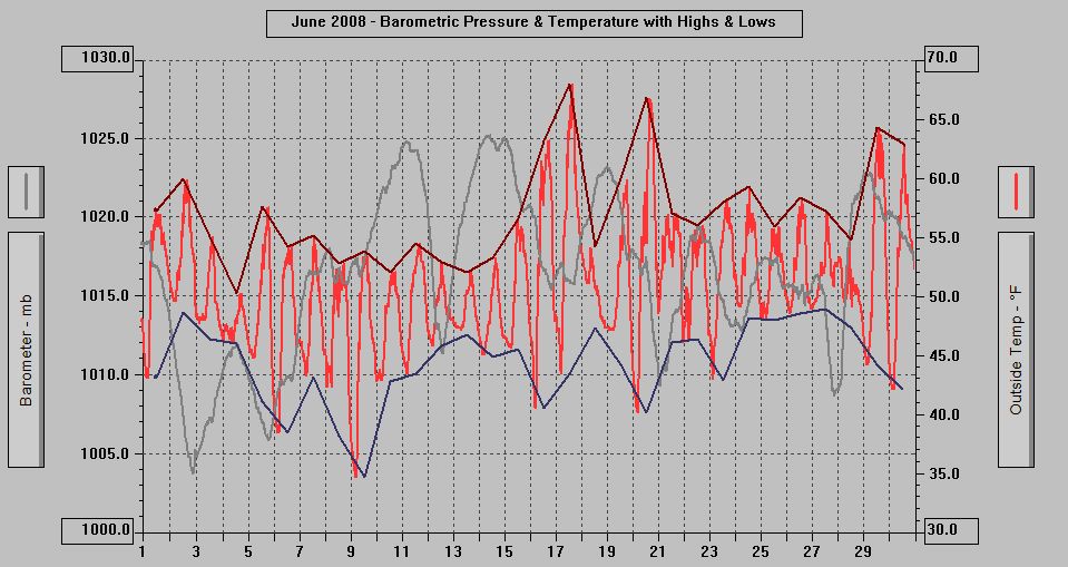
MINIMUM High Temp:	50.2	4th
MAXIMUM High Temp:	67.9	17th
AVERAGE Low Temp:	44.2
MINIMUM Low Temp:	34.7	9th
MAXIMUM Low Temp:	48.9	27th

MAX >= 90.0:		0
MAX >= 80.0:		0
MAX >= 70.0:		0
MAX <= 32.0:		0
MIN <= 32.0:		0
MIN <=  0.0:		0

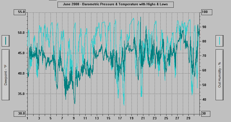
MAXIMUM Humidity (%):	96	19th @ 0707
MINIMUM Humidity (%):	36	17th @ 1649

MAXIMUM Pressure (mb):	1025.2	14th @ 0659
MINIMUM Pressure (mb):	1003.7	2nd @ 2114

TOTAL   Htg Deg Days:	426.0
AVERAGE Htg Deg Days:	14.2
MINIMUM Htg Deg Days:	8.9	17th
MAXIMUM Htg Deg Days:	19.4	9th
TOTAL Cool Deg Days:	0.2	0.1 on the 17th and 0.1 on the 20th
Heat Base:  65.0  Cool Base:  65.0  Method: Integration

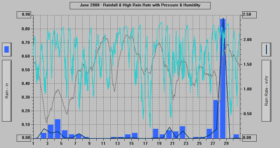
TOTAL   Precip.:	2.07
AVERAGE Precip. A:	0.094	(Per day, of the 22 days with measurable precip. Including the 5 days with a Trace = 0.077)
AVERAGE Precip. B:	0.067	(Per day)
DAYS of Precip.:	27	All but: 11th, 16th, 17th
MAXIMUM Precip.:	0.87	28th
MAXIMUM Rain Rate:	2.44	28th @ 0422
Days of Rain: 17 (>.01 in) 3 (>.1 in) 0 (>1 in)
TOTAL Snowfall:		0.0
DAYS of Snowfall:	0

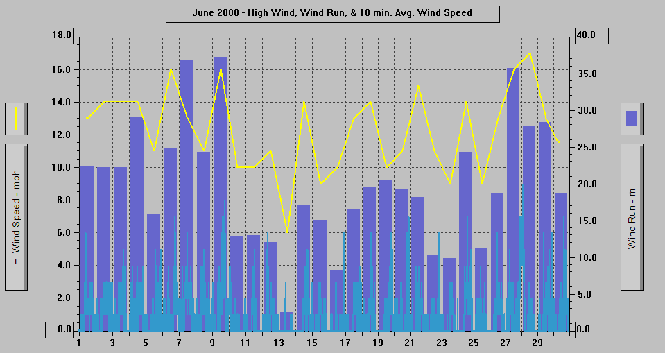
AVERAGE High Wind:	12.3
MINIMUM High Wind:	6	13th
MAXIMUM High Wind:	17	28th
WIND RUN (miles):	590.21

DAYS Full Sun any time: 17	All but: 3rd, 4th, 10th, 11th, 12th, 13th, 14th, 15th, 18th, 26th, 27th, 28th, 30th
DAYS Weak Vry Weak Sun: 3	15th, 26th, 30th
DAYS with Cld or M Cld:	30
DAYS OF Rainbow:	1	22nd from 1644-1709, to the ENE, Full then partial
DAYS OF Aurora:		0
DAYS OF Lightning:	0
DAYS OF Earthquake:	0

NWS Flood Watch / Flood Statement
Statement as of 1:09 PM AKDT on June 28, 2008

...The urban and small stream flood advisory for minor flooding of
poor drainage areas has been cancelled for Juneau Borough and
northern Admiralty Island...

Water levels in local area creeks and streams continues to fall and
no additional heavy precipitation is expected for the remainder of
the day.

Lat...Lon 5849 13473 5849 13439 5831 13439 5831 13473
NWS Flood Advisory
Statement as of 7:37 AM AKDT on June 28, 2008

The National Weather Service in Juneau has issued an

* urban and small stream flood advisory for minor flooding of poor
drainage areas in Juneau Borough and northern Admiralty Island...

* until 130 PM AKDT

* at 737 am AKDT water was observed flowing over the Montana Creek
Road bridge just before the gun range and was estimated to be 4
inches deep at that time.

* Heavy rainfall from last night has ended and water levels at
Montana creek as well as other local creeks...streams...and
drainage ditches are expected to begin falling by noon today.

A flood advisory means river or stream flows are elevated or ponding
of water in urban or other areas is occurring or is imminent.

Lat...Lon 5849 13473 5849 13439 5831 13439 5831 13473
time...Mot...loc 1537z 180deg 0kt 5840 13456
Record Event Report
Statement as of 6:42 AM ADT on June 21, 2008
National Weather Service Juneau AK
6:30 AM AKDT Sat Jun 21 2008

...New Record Low Temperatures for June 19 and 20...

June 19
Location             New Record     Old Record        Year Set
Ketchikan Airport       36              39              1968
Klawock*                38 (tie)        38              1985


June 20
Haines                  41              43              1980
Juneau Forecast Office* 36              39              1999

*unofficial records


Nb Jun 08
NWS Record Report
Statement as of 3:40 AM GMT on June 10, 2008

...Record low temperatures for June 9...

Location                 New Record     Old Record     Year Set
Juneau Airport               33             34           1974
Juneau Forecast Office       31             35           2007


Cvp Jun 08
Juneau's Electrical Power Usage:
DATE      POWER USED   FUEL USED
            MW/Hr      (Gallons)

June 2       608             0
June 1       578        32,525
May 31       566        34,580
May 30       593        35,820
May 29       598        36,631
May 28       591        36,023
May 27       598        36,812
May 26       570        34,402
May 25       551        33,388
May 24       567        34,528
May 23       610        37,651
May 22       632        39,285
May 21       633        42,542
May 20       622        39,106
May 19       635        39,835
May 18       615        38,788
May 17       617        39,792
May 16       666        43,726
May 15       648        41,375
May 14       671        46,370
May 13       660        45,893
May 12       671        46,785
May 11       604        42,970
May 10       602        42,800
May 9        625        45,160
May 8        645        46.750
May 7        659        47,504
May 6        660        46,355
May 5        671        46,711
May 4        665        48,575
May 3        653        50,272
May 2        661        52,522
May 1        679        54,361
April 30     683        54,773
April 29     694        55,042
April 28     712        56,553
April 27     667        54,046
April 26     677        55,062
April 25     697        56,350
April 24     695        54,148
April 23     689        51,680
April 22     719        55,766
April 21     743        58,490
April 20     746        56,581
April 19     795        61,555
April 18     856        72,985
April 17     912        79,940
April 16     948        84,147

Source: Alaska Electric Light & Power Co., Juneau, Alaska