MONTHLY CLIMATOLOGICAL
SUMMARY for DECEMBER 2005
CONDITIONS DAY of
Month: 1 2 3 4 5 6 7 8 9 10 11 12 13 14 15 16 17 18 19 20 21 22 23 24 25 26 27 28 29 30 31
NAME: 3270 Nowell   CITY: West Juneau   STATE: Alaska
ELEV:    97 ft  LAT: 58° 17' 33" N  LONG: 134° 25' 37" W


TEMPERATURE (°F), RAIN  (in), WIND SPEED (mph), SNOW (in). Snowfall from 21:00 - 21:00, all others Midnight to Midnight.

                                      HEAT  COOL        AVG                      WIND       SNOW
    MEAN                              DEG   DEG         WIND                DOM  RUN        ON(1)
DAY TEMP  HIGH   TIME   LOW    TIME   DAYS  DAYS  RAIN  SPEED HIGH   TIME   DIR  (mi)  SNOW GRND WEATHER
-----------------------------------------------------------------------------------------------------------------------------------------------------
 1  21.3  26.0   1:45p  15.9   5:55a  43.7   0.0  0.00   3.2  19.0   6:55p  WSW  77.09  0.0  0.0 Clear MClr PCld MCld-Thin/VeryThinClds PCld MClr Clr
 2  20.9  23.6   1:10a  18.8  12:05a  44.1   0.0  0.00   4.4  28.0   6:50p  ENE 105.23  0.0  0.0 Clear Lt-BrzyWind/OccGusts PCld Cldy MostlyCldy Cld
 3  24.0  27.8   3:45p  18.8   1:25a  41.0   0.0  0.17   1.3  16.0   8:00a  SSE  30.75  4.8  4.8 Cld Cld/Snow-LtSn-ExtrmLtSn FewCldPeriods Cld/Sn Cld
 4  21.4  27.3  11:55a  14.3  11:50p  43.6   0.0 TRACE   1.2   7.0   5:45a  WSW  30.02  0.2  4.0 Cldy LtSn Cld M/PCld PCld MClear Clear
 5  22.0  26.9   5:45p  13.6   1:05a  43.0   0.0  0.00   0.7   8.0   5:30p  WSW  16.92  0.0  3.4 Clear IncrCld CloudyByMorning Cloudy
 6  29.7  34.9  12:00m  26.1  12:05a  35.3   0.0  0.20   0.4   6.0   6:25p  SSE   9.04  0.3  2.9 Cld Cld/OccLt-VryLtSn Cld-VarLrCld/Mist-Spr-LtRn-Rn
 7  36.9  40.9   9:55p  33.1   3:00a  28.1   0.0  0.35   3.1  22.0   9:15p  SSE  73.45  0.0  0.5 Cld/BitofRn Cldy Cld/Mist Cld/LtRn Cld/Rn
 8  39.2  42.1  10:30a  35.9   5:05p  25.8   0.0  1.44   3.5  20.0  12:10a  SSE  84.87  0.0  0.0 Cldy/Rain LtRn-Drizzle Misting-Sprinkling Cld/Rn Cld
 9  41.2  42.6   9:35a  36.8  12:05a  23.8   0.0  0.65   4.8  25.0   6:50p  SSE 114.91  0.0  0.0 Cld/Rn Cldy Cld/LtRn-Rn-Mist-Drizzle Breezy
10  39.7  43.2   2:00a  37.0   9:00p  25.3   0.0  0.13   1.3  17.0   4:20a  SSE  32.19  0.0  0.0 Cld/Rn Cldy MCld PCld CldBrks Cld PCld Cld-Fog LtRn
11  39.9  42.8   7:20p  37.3  12:05a  24.9   0.0  1.03   2.7  32.0  10:10p    S  65.23  0.0  0.0 Cld/Rn-LtRn-Spr Cld/ThinSpots Cld/Rn/Brzy-Windy
12  38.8  41.2  12:25a  33.7  11:45p  26.2   0.0  0.62   3.1  25.0  12:35a    S  74.97  0.0  0.0 Cld/Rn/Wind Cld/LtRn-Spr Cld Cld/LtRn SmBrks Cld/Spr
13  35.1  36.5   1:35p  33.8  12:05a  29.9   0.0  0.03   0.3   6.0   8:05p    S   7.02  0.0  0.0 Cldy Cld/ThinSpots-Areas Cld/LtRn-Spr Cldy
14  36.5  38.0   9:10p  34.9  12:05a  28.5   0.0  0.19   1.4  14.0  11:05p    S  33.67  0.0  0.0 Cldy Cld/VryLtRn-Spr FewCldyPeriods Cld/LtRn-Rn
15  40.3  44.6  10:55p  34.6  12:15a  24.7   0.0  0.25   3.7  16.0  12:50p  SSE  89.87  0.0  0.0 Cld/Rn Cld/Spr-Mist Cld Cld/LtSpr-Mist-VryLtRn Cld
16  41.0  46.1   3:50p  36.2   9:50p  24.0   0.0  0.01   1.4  16.0   8:00a    S  34.22  0.0  0.0 Cld/Rn PCldy VarThin-VryThinCld VarCld-MCld ThinClds
17  37.6  41.6  10:25a  31.2  11:45p  27.4   0.0  0.00   1.3  13.0   5:55a    S  30.11  0.0  0.0 Cld/MCld ThinOvcst Cld-Thinspots VarP/MCldy-ThinClds
18  31.8  34.4   5:55a  28.4  11:55p  33.2   0.0  0.00   0.7   5.0   1:30p    W  16.12 FRST  0.0 M/PCld-ThinVryThinClds MCld/PCld Pcld MClr Clr-Fog
19  28.7  30.3  12:55p  27.3  10:50p  36.3   0.0  0.00   0.9   7.0  10:15p    S  22.07 FRST  0.0 Clr-VarLwrFog HvyFrost Clr-FogBand Fog PCld/Clr Clr
20  36.3  41.5   8:55a  27.3  12:40a  28.7   0.0  0.49   2.2  34.0   8:50a    S  52.32  0.0  0.0 Clr Cldy OccVryLtRn Windy Cld/Spr-Rn-LtRn-VryLtRn-Rn
21  44.1  45.7  10:35a  39.3  12:40a  20.9   0.0  0.58   4.9  29.0   4:00a  SSE 116.56  0.0  0.0 Cld/Rn/Wind Cld/VryLtRn-Rn Cld Cld/LtRn-Mist-Spr Cld
22  41.5  43.5   7:40p  39.8  10:05a  23.5   0.0  0.06   0.4   7.0   3:05p    S  10.36  0.0  0.0 Cldy Fog PatchyFog-MCld Cld Cld/Spr-VryLtRn
23  41.1  43.6   4:30a  38.2   8:15p  23.9   0.0  0.20   2.7  20.0   7:25a    S  63.60  0.0  0.0 Cld/Rn-LtRn-Mist-Spr Brzy Cld/TinyBrks-Brks MCld Cld
24  40.2  42.8  12:25p  38.5  12:05a  24.8   0.0  0.15   1.3  10.0   4:05a    S  30.04  0.0  0.0 Cld Cld/LtRn-Mist-Spr Cld/Rn Cld Cld/VryLtRn-Spr
25  36.9  38.9  12:05a  34.4  12:00m  28.1   0.0  0.18   1.2   8.0  12:10a    S  28.56  0.0  0.0 Cld-LowClds/Rn-LtRn-Drizz-Mist-Spr Cld/Brks LowClds
26  34.9  41.6   3:50p  30.7   9:00a  30.1   0.0  0.05   2.5  36.0   4:05p    S  60.03  0.0  0.0 Fog Ovcst M/PCld MCld/Cld-Ovcst Windy Cld Cld/Rn Cld
27  39.1  45.5   7:35a  33.7   2:55a  25.9   0.0  0.27   3.0  35.0   7:20a    S  71.90  0.0  0.0 Cld/Rn PCld Ovcst Windy Cld/Spr-LtRn-Mist-Rn
28  42.8  50.7   3:05p  35.9   8:40a  22.2   0.0  0.07   4.6  32.0  11:50a    S 109.74  0.0  0.0 Cld/Rn PCld MCld-Clr MCld Cld/Brzy-Windy Cld/Spr-Rn
29  41.6  46.0  10:10p  38.3   4:20p  23.4   0.0  0.15   5.1  38.0  10:20p    S 122.67  0.0  0.0 Cld/Rn-LtRn-Mist-Spr Cld/Brks PCld MCld Cld Windy
30  41.6  46.8   3:25a  38.5   6:40p  23.4   0.0  0.05   3.7  36.0  12:05a    S  87.93  0.0  0.0 Cldy Windy Cldy Cld/LtSpr-VryLtRn Cldy Cld/LtRn
31  34.6  40.9   8:50p  30.1   8:15a  30.1   0.0  0.00   2.2  26.0   8:50p    W  51.87  0.0  0.0 Cld Clr Fog PCld M/PCld Cld-Ovcst Brz-Gusts PCld Cld
-----------------------------------------------------------------------------------------------------------------------------------------------------
    35.5  50.7    28    13.6     5   913.8   0.0  7.32   2.4  38.0    29     S 1753.33  5.3

(1) As measured on Front Lawn
STATISTICS | DATA | GRAPHS | CONDITIONS - DAY of MONTH: 1 2 3 4 5 6 7 8 9 10 11 12 13 14 15
16 17 18 19 20 21 22 23 24 25 26 27 28 29 30 31| TOP
AVERAGE Mean Temp: 35.5
AVERAGE High Temp: 39.3
MINIMUM High Temp: 23.6 2nd
MAXIMUM High Temp: 50.7 28th
AVERAGE Low Temp: 31.4
MINIMUM Low Temp: 13.6 5th
MAXIMUM Low Temp: 39.8 22nd
MAX >= 90.0: 0
MAX >= 80.0: 0
MAX >= 70.0: 0
MAX <= 32.0: 6
MIN <= 32.0: 12
MIN <= 0.0: 0
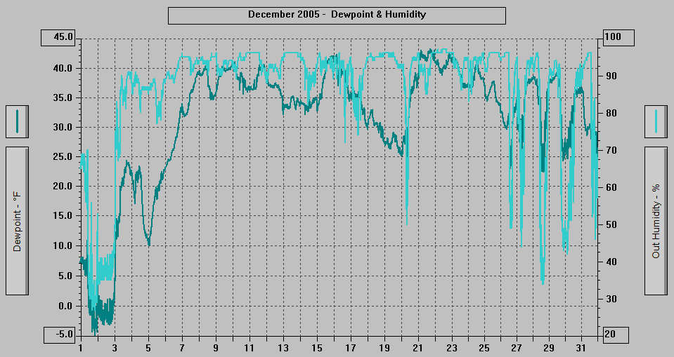
MAXIMUM Humidity (%): 97 22nd @ 0257
MINIMUM Humidity (%): 27 1st @ 1609
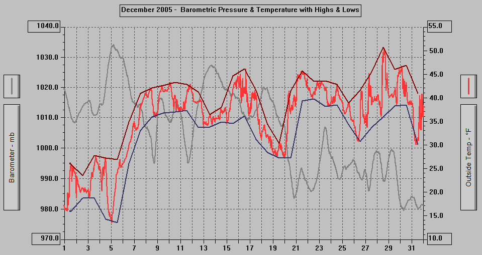
MAXIMUM Pressure (mb): 1034.2 5th @ 0514
MINIMUM Pressure (mb): 979.6 30th @ 0659
TOTAL Htg Deg Days: 913.8
AVERAGE Htg Deg Days: 29.5
MINIMUM Htg Deg Days: 20.9 21st
MAXIMUM Htg Deg Days: 44.1 2nd
TOTAL Cool Deg Days: 0
Heat Base: 65.0 Cool Base: 65.0 Method: Integration
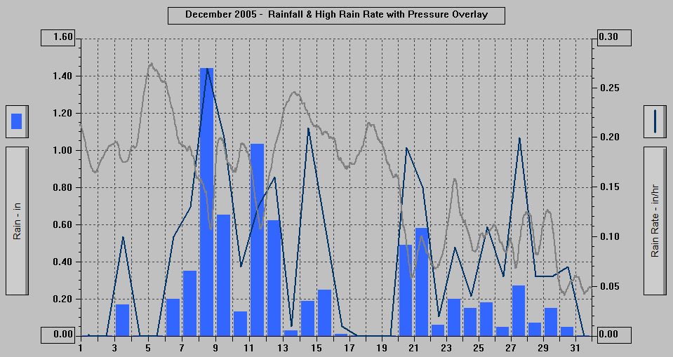
TOTAL Precip.: 7.32
AVERAGE Precip.: 0.3
DAYS of Precip.: 24 All but: 1st, 2nd, 5th, 17th, 18th, 19th, 31st
MAXIMUM Precip.: 1.44 8th
MAXIMUM Rain Rate: 0.27 8th @ 1648
Days of Rain: 22 (>.01 in) 17 (>.1 in) 2 (>1 in)
TOTAL Snowfall: 5.3
DAYS of Snowfall: 3 3rd, 4th, 6th
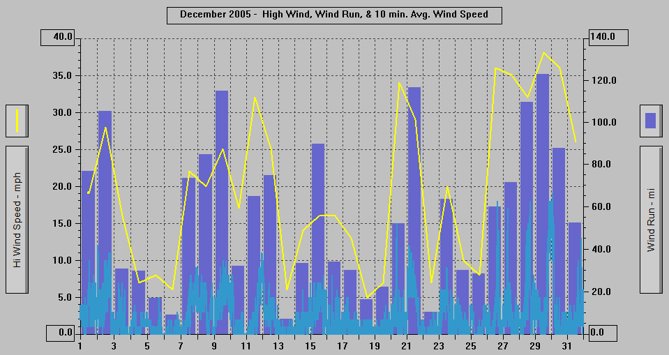
AVERAGE High Wind: 19.8
MINIMUM High Wind: 5 18th
MAXIMUM High Wind: 38 29th @ 2215
WIND RUN (miles): 1753.33
DAYS Sun at any time: 11 1st, 2nd, 4th, 10th, 16th, 17th, 18th, 19th, 26th (Weak), 29th (Weakened), 31st
DAYS OF Clr or M Clr: 1 19th
DAYS OF Cld or M Cld: 31
DAYS OF Rainbow: 0
DAYS OF Aurora: 0
DAYS OF Lightning: 0
DAYS OF Earthquake: 1 29th @ 1158, 4.2 magnitude, 104 miles WNW of Juneau
12/31/05: DATA | New Year's Eve
- 2050 AST: Cloudy, Breezy-Windy.
- 2035: Cloudy, wind is picking up.
- 1950: Cloudy.
- 1850: Partly Cloudy/Clear.
- 1750: Partly Cloudy/Clear.
- 1735: Mostly/Partly Cloudy, some stars visible.
- 1650: Partly Cloudy (or mostly cloudy?),
a few stars visible, light to breezy wind
with occasional stronger gusts.
- 1620: Cloudy-Overcast, Breezy with stronger
gusts.
- 1550: Cloudy-Overcast, some thin fog over
the Channel NW of the Bridge; periodically
(phenomenon first began 1527) wisps and bits
of fog/clouds blowing in from the NW and
then rising vertically SE of the Bridge,
but before Gold Creek, dispersing, re-forming
and doing a "dance" as wind from
the ENE and E collides with the air from
the NW. Seagulls enjoying the winds for a
short time.
- 1450: Mostly Cloudy (still mostly thin and
very thin clouds).
- 1405: Mostly/Partly Cloudy, a few lower wisps
of fog/clouds.
- 1350: Mostly/Partly Cloudy with fog over
the Channel.
- 1250: Mostly Cloudy, band of fog low over
the Channel, weak sunshine on the mountaintops.
- 1150: Mostly Cloudy SE half of sky, Partly
Cloudy NW half, band of fog low over the
Channel, weakened sunshine on the mainland
mountains.
- 1050: Partly Cloudy with high thin and very
thin clouds, band of fog over the Channel.
- 0950: Fog, hint of blue overhead.
- 0850: Partly Cloudy with high thin and very
thin clouds, band of fog over the Channel,
there was some fog in the neighborhood 20
minutes ago.
- 0750: Clear with variable fog rising and
falling over the Channel. Light frost on
the lawns and roofs.
- 0650: Clear with a band of fog low over Gastineau
Channel.
- 0620 AST: Clear with a lower ribbon of fog.
- 2050 AST: Cloudy.
- 1950: Extremely Light Sprinkling (hardly
detectable), Cloudy.
- 1850: Cloudy.
- 1750: Sprinkling/Very Light Rain, Cloudy.
- 1650: Cloudy.
- 1550: Light Sprinkling, Cloudy with a few
lower wisps of fog/clouds, inner Gold Creek
valley partially obscured.
- 1450: Sprinkling/Very Light Rain, Cloudy
with the inner Gold Creek valley and very
top of Mt. Roberts partially obscured.
- 1350: Very Light Sprinkling, Cloudy with
the inner Gold Creek valley and top of Mt.
Roberts partially obscured.
- 1250: Light Sprinkling, Cloudy.
- 1150: Cloudy, there has been some precipitation
in the inner Gold Creek valley in the past
hour.
- 1050: Cloudy.
- 1010: Wind Advisory cancelled.
- 0950: Cloudy.
- 0850: Cloudy.
- 0750: Cloudy.
- 0650: Cloudy.
- 0620 AST: Cloudy. Windy overnight tapering
off beginning at 0420.
- 0600: Wind Advisory extended until 11 A.M.
12/29/05: DATA | 1600: Wind Advisory now in effect 9 P.M.
tonight to 3 A.M Friday | New High Temperature
Records set in SE Alaska 12/28 - See Below
- 2050 AST: Cloudy, Breezy with occasional
stronger gusts.
- 2020: Cloudy, Windy.
- 1950: Cloudy, light to breezy wind with occasional
stronger gusts.
- 1920: Cloudy, Breezy-Windy.
- 1850: Cloudy with a few thinner spots with
hints of stars, breezy with stronger gusts.
- 1750: Partly Cloudy, occasional gusts of
wind.
- 1650: Mostly Cloudy/Cloudy with thinner areas
in which some stars are visible.
- 1600: Wind Advisory now in effect 9 P.M.
tonight to 3 A.M Friday
- 1550: Cloudy with high thin and very thin
clouds with a lower level of thicker clouds
(appearing partly/mostly cloudy except it
is high thin and very thin clouds in the
"clear" areas).
- 1450: Cloudy with a few very tiny breaks.
- 1350: Very Light Sprinkling, Cloudy with
a few hints of blue.
- 1250: Mostly/Partly Cloudy.
- 1235: Partly Cloudy with spots of weakened
sunshine on the mainland.
- 1158: A 4.2 magnitude earthquake, depth 3
miles, 58.655°N, 137.363°W, 104 miles WNW of Juneau, 79 miles SW of Haines,
92 miles SW of Skagway, 48 miles NW of Elfin
Cove, 61 miles WNW from Gustavus, 63 miles
NW from Pelican, was felt by an employee
in the Blomfield Building on West 8th Street
in downtown Juneau. http://pasadena.wr.usgs.gov/shake/ak/STORE/X55144_05/ciim_display.html
- 1150: Cloudy with a few breaks to the NW.
- 1120: Cloudy with small breaks in the NW
part of the sky.
- 1050: Sprinkling, Cloudy.
- 1005: Very Light Rain, Cloudy with a few
lower wisps on the Channel side of Mt. Juneau.
- 0950: Extremely Light Misting/Sprinkling,
Cloudy with a tiny break to the NW, clouds
skimming the mountaintops.
- 0850: Light Misting, Cloudy with the very
tops of the mountains in the clouds.
- 0750: Light Misting-Drizzle-Sprinkling, Cloudy
with clouds skimming Mt. Juneau and the Mt.
Juneau Ridge and the very top of Mt. Roberts
in the clouds.
- 0650: A few very light sprinkles, cloudy
with the very tops and tops of the mountains
in the clouds.
- 0620 AST: Very Light Misting/Sprinkling,
Cloudy with the mountaintops in the clouds.
- 0600: Wind Advisory in effect Midnight tonight
to 6 A.M. Friday
- New High Temperature Records set in SE Alaska
12/28. New high temperature record of 50.7
degrees F set at the West Juneau Weather
Station, exceeding the previous high of 46
set in 1999 (records since December 1984).
| NWS Record Report |
|
|
Statement as of 1:15 am AST on December 29,
2005
... Record high temperatures in Southeast
Alaska for Wed Dec 28 2005...
Location new record old record year set
Petersburg 52 49 1995
Wrangell 48 47 1999
Sitka 52 50 2001
Klawock 52 51 2001
Juneau 47 46 1995
Bwt Dec 05
|
- Midnight: New high temperature record of
50.7 degrees F set at the West Juneau Weather
Station on 12/28, exceeding the previous
high of 46 set in 1999 (records since December
1984).
- 2050 AST: Extremely Light Misting/Sprinkling,
Cloudy. .01" of Rainfall so far today.
- 2020: Very Light Rain, Cloudy with the wind
picking up and the rain hitting the Channel
side windows.
- 1950: Cloudy.
- 1850: Cloudy.
- 1750: Cloudy.
- 1720: Cloudy.
- 1650: Cloudy, Breezy-Windy.
- 1550: Cloudy, Breezy-Windy, whitecaps on
the Channel.
- 1450: Cloudy, Breezy-Windy, some whitecaps
on the Channel.
- 1350: Cloudy, Breezy-Windy, some whitecaps
on the Channel and a bit of blowing spray.
- 1250: Cloudy, Breezy with occasional stronger
gusts, a few whitecaps on the Channel.
- 1150: Cloudy, Breezy at times with occasional
stronger gusts, a few whitecaps on the Channel.
- 1050: Cloudy, Breezy with occasional stronger
gusts, a few whitecaps on the Channel.
- 1039: Cloudy, wind is picking up, some whitecaps
on the Channel.
- 0950: Cloudy with a few very tiny breaks,
some clear sky far to the NW.
- 0920: Cloudy with partly broken skies in
NW part and further NW partly cloudy with
the high very thin clouds.
- 0850: Mostly Cloudy with high thin and very
thin clouds in the "clearer" areas,
variable lower bits and wisps of fog/clouds
over Gastineau Channel.
- 0750: Cloudy with some thinner areas, breaks
far to the SE.
- 0735: Mostly Cloudy.
- 0650: Cloudy/Mostly Cloudy NW part of sky,
Mostly Clear SE part.
- 0630: New Weekly Picture posted.
- 0620 AST: Partly Cloudy (clear with lower
level scattered clouds).
- 2050 AST: Very Light Rain, Cloudy with the
mainland mountains slightly obscured. .20"
of Rainfall so far today.
- 1950: Rain, Cloudy.
- 1850: Very Light Rain, Cloudy.
- 1800: .11" of Rainfall so far today.
- 1750: Extremely Light Sprinkling, Cloudy
with a few breaks in which a few stars can
be faintly seen.
- 1705: Rain, Cloudy with lower band of fog/clouds.
- 1650: Light Rain, Cloudy with the mainland
mountains slightly obscured.
- 1550: Very Light Sprinkling/Misting, Cloudy
with some clouds around the mountaintops.
- 1500: .04" of Rainfall so far today.
- 1535: Light Rain, Cloudy with some clouds
around the mountaintops.
- 1450: Extremely Light Sprinkling, Cloudy
with clouds skimming the mountaintop and
a thinner spot with a hint of blue.
- 1420: Very Light Sprinkling/Misting, Cloudy
with the very top of Mt. Roberts slightly
obscured, light yellowish glow on parts of
the mainland mountaintops.
- 1350: Cloudy with a few wisps around the
top of Mt. Roberts.
- 1335: Light Rain, Cloudy.
- 1250: Cloudy, some precipitation in the inner
Gold Creek valley and over the top of Mt.
Roberts.
- 1235: Sprinkling, Cloudy with a few lower
wisps and ribbons on the Channel side of
Mt. Juneau, brighter skies.
- 1220: Light Rain, Cloudy with the inner Gold
Creek valley partially obscured.
- 1200: .02" of Rainfall so far today.
- 1150: Light Rain, Cloudy with the upper parts
of the mainland mountains slightly-partially
obscured and the inner Gold Creek valley
obscured by snow falling at the higher elevations.
- 1135: Sprinkling/Very Light Rain, Cloudy
with the very top of Mt. Roberts and the
inner Gold Creek valley obscured.
- 1050: Cloudy-Overcast with precipitation
over Mt. Roberts and in the inner Gold Creek
valley.
- 1015: Wind Advisory cancelled by NWS.
- 0950: Cloudy-Overcast.
- 0850: Cloudy-Overcast.
- 0750: Cloudy-Overcast.
- 0650: Cloudy-Overcast, Windy.
- 0635: Cloudy-Overcast, Windy.
- 0620 AST: Cloudy-Overcast. .01" of Rainfall
since midnight.
- 0605: Wind Advisory in effect until Noon.
12/26/05: DATA | 1530: Wind Advisory in effect 3 A.M. -
9 A.M. Tuesday | Federal, State, & Local
Holiday in observance of Christmas
- 2050 AST: Sprinkling/Very Light Rain, Cloudy
with the upper parts of the mountains hidden.
- 1950: Very Light Sprinkling, Cloudy with
some lower fog/clouds.
- 1850: Occasional very tiny sprinkles, cloudy.
- 1750: Cloudy.
- 1720: Cloudy, Breezy-Windy with occasional
stronger gusts.
- 1650: Cloudy.
- 1550: Cloudy, Breezy-Windy, whitecaps on
the Channel.
- 1505: Cloudy, Breezy-Windy, a few whitecaps
on the Channel.
- 1450: Cloudy, light to breezy wind.
- 1420: Cloudy - Overcast, light to breezy
wind.
- 1350: Cloudy - Overcast.
- 1320: Cloudy - Overcast.
- 1250: Mostly Cloudy NW 2/3rds of sky, cloudy
SE 1/3rd.
- 1150: Cloudy with breaks and thin areas where
blue is visible, a few lower bits and wisps
of fog/clouds, weak sunshine on parts of
the mainland.
- 1050: Mostly Cloudy with variable fog over
the Channel.
- 0950: Mostly/Partly Cloudy, Variable Fog
over the Channel.
- 0850: Overcast with thinner areas where there
is some blue visible and small breaks to
the SE, band of fog low over the Channel.
- 0750: Overcast with thinner areas, breaks,
band of fog over the Channel.
- 0735: Overcast with thinner areas, breaks
in SE part, band of fog low over Gastineau
Channel.
- 0650: Fog.
- 0620 AST: Fog.
SUNDAY 12/25/05: DATA | Christmas Day - The birth of our Lord & Savior Jesus
Christ who died on the Cross for our sins.
- 2050 AST: Cloudy with lower fog/clouds hiding
the mainland above the 200' - 400' elevation.
- 2005: Cloudy with lower fog/clouds hiding
the mainland above the 200' - 400' elevation.
- 1850: Cloudy with lower fog/clouds hiding
the mainland above the 100' - 300' elevation.
- 1750: Cloudy with lower fog/clouds hiding
the mainland above the 100' - 200' elevation.
- 1650: Cloudy with lower fog/clouds hiding
much of the mainland above the 200' -400'
elevation.
- 1550: Cloudy with small breaks, breaks, hints
of breaks, and thin spots.
- 1450: Cloudy with very tiny breaks and hints
of breaks SE 2/3rds of sky, area of partly
cloudy sky in the NW part, a few lower bits
and wisps of fog/clouds, Blueberry Hills
in the fog.
- 1350: Cloudy with a few hints of blue through
the clouds, very tops of the mountains in
the clouds, lower ribbons and wisps of fog/clouds.
- 1250: Cloudy with breaks and thin areas with
blue visible in the NW half of the sky, very
tops of the mountains in the clouds with
lower band of fog/clouds, precipitation over
parts of the mainland.
- 1200: .18" of Rainfall to this point
today.
- 1150: Cloudy with a small area to the N with
blue visible through thin clouds-breaks,
a few lower wisps, Blueberry Hills in fog.
- 1120: Cloudy with breaks in the northern
part of the sky, lower ribbons and wisps
of fog/clouds.
- 1050: Cloudy with a few small and tiny breaks,
some fog/clouds around the very tops of the
mountains, lower ribbon of fog/clouds.
- 0950: Cloudy with some tiny breaks, breaks
and thin spots where blue is visible, very
tops of the mountains in the clouds and a
lower ribbon and wisps.
- 0920: Cloudy with very tops of the mountains
in the clouds and a lower ribbon and wisps,
Blueberry Hills had been in fog, snow level
on the mountains is down to about 1200'.
- 0850: Cloudy with precipitation and mists
over the mainland, fog/clouds hiding the
mainland mountains above 700' - 800'.
- 0750: Light Misting, Cloudy with the mainland
mountains hidden above the 400' - 500' elevation
by fog/clouds.
- 0700: .17" of Rainfall so far today.
- 0650: Very Light Misting/Sprinkling, Cloudy
with the upper parts of the mainland mountains
hidden by fog/clouds.
- 0620 AST: Light Misting/Drizzle with lower
fog/clouds hiding much of the mainland mountains
above 600' - 800'.
12/24/05: DATA | Christmas Eve
- 2050 AST: Sprinkling/Very Light Rain, Cloudy.
- 1950: Very Light Rain, Cloudy with some lower
wisps.
- 1850: Very Light Sprinkling/Misting, Cloudy.
- 1900: .09" of Rainfall so far today.
- 1750: Very Light Sprinkling/Misting, Cloudy
with a few lower wisps.
- 1650: Sprinkling/Light Misting, Cloudy.
- 1620: Very Light Sprinkling, Cloudy.
- 1550: Sprinkling/Very Light Rain, Cloudy
with the top of the Mt. Juneau Ridge hidden.
- 1535: Very Light Rain/Sprinkling, Cloudy.
- 1450: Cloudy.
- 1350: Sprinkling, Cloudy.
- 1250: Cloudy.
- 1150: Cloudy with a few lower wisps.
- 1050: Extremely Light Sprinkling (hardly
detectable), Cloudy with a few lower wisps.
- 0932-0934: A Steller's Jay is taking a bath
in the Bird Bath.
- 0850: Cloudy with a few lower wisps and ribbons
of fog/clouds. .06" of Rainfall so far
today.
- 0750: Rain, Cloudy. .04" of Rainfall
so far today.
- 0650: Extremely Light Misting (hardly detectable),
Cloudy.
- 0620 AST: Light Sprinkling/Misting, Cloudy.
.01"of Rainfall so far today.
- 2050 AST: Cloudy.
- 1950: Mostly Cloudy.
- 1850: Cloudy with some breaks and thin spots.
- 1750: Cloudy.
- 1650: Mostly Cloudy.
- 1550: Cloudy with small and tiny breaks.
- 1450: Cloudy with some tiny breaks.
- 1435: Cloudy with a few broken areas and
small breaks.
- 1420: Cloudy with tiny breaks, clouds skimming
the mountaintops, precipitation in Last Chance
Basin and the inner Gold Creek valley.
- 1350: Cloudy with bright areas, very top
of Mt. Juneau and Mt. Roberts in the clouds,
clouds skimming the Mt. Juneau Ridge with
some precipitation in the Granite Creek area.
- 1335: Cloudy with the very top of Mt. Juneau
and Mt. Roberts in the clouds.
- 1314: A weak spot of sunshine on part of
Mt. Juneau above Last Chance Basin.
- 1250: Cloudy with the very tops and tops
of the mountains in the clouds (Mt. Roberts
hidden above 2500').
- 1235: Cloudy with the very tops and tops
of the mountains in the clouds.
- 1159: The Squirrel is visiting.
- 1150: Very Light Rain, Cloudy with the very
tops of the mountains in the clouds.
- 1120: Light Rain, Cloudy with the top of
Mt. Roberts and very top of Mt. Juneau in
the clouds, a few whitecaps on the Channel.
- 1050: Cloudy with the mountaintops in the
clouds.
- 0950: Sprinkling/Very Light Rain, Cloudy
with the mountaintops in the clouds, a few
whitecaps on the Channel.
- 0850: Very Light Misting/Sprinkling, Cloudy
with the very tops and tops of the mountains
in the clouds, some whitecaps on the Channel.
- 0835: Some whitecaps are visible on Gastineau
Channel.
- 0750: Sprinkling/Very Light Rain, Cloudy
with the mountaintops in the clouds.
- 0720: Sprinkling/Light Misting, Cloudy with
very top of Mt. Juneau and top of Mt. Roberts
in the clouds.
- 0650: Light Rain, Cloudy.
- 0620 AST: Very Light Misting/Sprinkling,
Cloudy with the mainland mountains slightly
obscured.
12/22/05: DATA 0830: Dense Fog Advisory to 11 A.M. | New
High Temp. Records in SE Alaska yesterday
- See Below
- 2050 AST: Sprinkling/Very Light Rain, Cloudy.
- 1950: Cloudy.
- 1850: Cloudy with a few lower wisps of fog/clouds.
- 1750: Cloudy.
- 1650: Cloudy.
- 1635: Cloudy.
- 1550: Cloudy with the very top of Mt. Juneau
and Mt. Roberts in the clouds, precipitation
in the inner Gold Creek valley.
- 1520: Cloudy with a few lower wisps of fog/clouds.
- 1450: Cloudy with some precipitation over
parts of the mainland, a few lower wisps
in Last Chance Basin and on the Channel side
of Mt. Juneau.
- 1350: Sprinkling (began at 1348), Cloudy
with lower ribbon/band of fog/clouds, view
of Douglas Island mountains hidden.
- 1250: Cloudy with a few lower ribbons, Blueberry
Hills in fog.
- 1220: Cloudy with a few lower ribbons and
wisps, Blueberry Hills in fog.
- 1150: Sprinkling, Cloudy with lower bands-ribbons
of fog/clouds, the upper part of Pioneer
Avenue and Blueberry Hills in fog.
- 1120: Extremely Light Sprinkling, Cloudy-Foggy
with fog as low as 100' hiding the mainland
mountains and the upper parts of downtown,
the upper part of Pioneer Avenue and Blueberry
Hills in fog.
- 1050: Variable Fog over the Channel hiding
most of the mainland, foggy/cloudy overhead.
- 1020: Fog over the Channel hiding the mainland
and fog overhead with hints of blue above.
- 0950: Patchy Fog, can see the mainland mountaintops,
mostly cloudy sky.
- 0850: Fog.
- 0830: NWS issued a Dense Fog Advisory to
11 A.M.
- 0750: Fog.
- 0650: Fog (lights of downtown can't be seen
now).
- 0620 AST: Fog, can see lights of downtown
Juneau closest to Gastineau Channel.
- Record Temperatures in 4 Southeast Alaska
communities on December 21.
| NWS Record Report |
|
|
Statement as of 9:15 PM AST on December 21,
2005
... Record high temperatures in Southeast
Alaska...
Location new record old record year set
Petersburg 48 47 1985
Wrangell 50 44 1999
Kake 48 45 1976
Klawock 50 48 2003
Tar Dec 05
|
12/21/05: DATA | Wind Advisory in effect until 10 A.M.
| Winter Solstice at 0935 AST | Subtract
.01" from the monthly rain total (see
12/20).
- 2050 AST: Very Light Sprinkling/Misting,
Cloudy with lower fog/clouds hiding the mainland
above about the 400' elevation, Blueberry
Hills in fog.
- 1950: Cloudy with the mountaintops in the
clouds, Blueberry Hills in fog.
- 1850: Extremely Light Misting/Sprinkling,
Cloudy with lower ribbons, bands, wisps and
bits of fog/clouds.
- 1750: Light Misting, Cloudy with lower bands
and ribbons of fog/clouds.
- 1735: Very Light Misting/Sprinkling after
a period of heavier rain, cloudy with lower
bands and ribbons of fog/clouds.
- 1650: Very Light Misting/Sprinkling, Cloudy
with the mainland mountains slightly-partially
obscured.
- 1550: Extremely Light Misting/Sprinkling,
Cloudy with the very tops of the mountains
in the clouds.
- 1450: Light Sprinkling, Cloudy with the mountaintops
in the clouds.
- 1420: Rain, Cloudy with the mountaintops
in the clouds.
- 1405: Light Rain, Cloudy with the mountaintops
in the clouds.
- 1350: Cloudy with the mountaintops in the
clouds, precipitation over parts of the mainland.
- 1335: Light Rain, Cloudy with the mountaintops
in the clouds.
- 1250: Cloudy with tiny breaks and hints of
blue, very tops of the mountains in the clouds.
- 1205: A Mountain Goat spotted on Mt. Juneau.
- 1150: Cloudy with bright spots and the very
tops of the mountains in the clouds.
- 1050: Light Sprinkling/Misting, Cloudy with
the very tops of the mountains in the clouds.
- 1020: Cloudy with clouds skimming the top
of Mt. Juneau and the very top of Mt. Roberts
and the Mt. Juneau Ridge in the clouds, breezy.
- 0950: Very Light Sprinkling, Cloudy with
the very tops of the mountains in the clouds.
- 0935: Winter Solstice.
- 0850: Very Light Rain, Cloudy with the very
top of Mt. Juneau and top of Mt. Roberts
in the clouds.
- 0750: Light Rain, Cloudy with very tops of
the mountains in the clouds, breezy, windier
over Gastineau Channel.
- 0650: Rain, Cloudy, Breezy with occasional
stronger gusts
- 0634: New Weekly Picture posted
- 0620 AST: Very Light Rain, Cloudy with the
very tops of the mountains in the clouds,
breezy with occasional stronger gusts - windier
over the Channel.
- Sheep Mountain has had winds to over 100
mph overnight.
12/20/05: DATA | Because of Melting frost being erroneously
registered as rain there is .01" of
precipitation for today that should be subtracted
from figures shown on the main weather page
and graphs page today - yearly totals are
OK (others will be OK tomorrow though the
monthly total will show as .01" more,
but the monthly and yearly statistics pages
will show the proper values).
- 2050 AST: Light Sprinkling/Misting, Cloudy.
- 2020: Sprinkling, Cloudy.
- 1950: Very Light Rain/Sprinkling, Cloudy.
- 1850: Light Rain, Cloudy.
- 1805: Light Rain, Cloudy.
- 1750: Very Light Rain, Cloudy.
- 1735: Sprinkling/Very Light Rain, Cloudy.
- 1650: Cloudy.
- 1550: Very Light Rain, Cloudy with a cloud
in the inner Gold Creek valley.
- 1450: Light Rain, Cloudy with a bit of fog/clouds
around part of the top of Mt. Juneau.
- 1350: Rain, Cloudy.
- 1250: Very Light Sprinkling, Cloudy.
- 1150: Light Rain, Cloudy with thin areas
and spots with hints of blue visible in those
areas.
- 1050: Sprinkling, Cloudy.
- 1035: Cloudy.
- 0950: Sprinkling, Cloudy with the top of
Mt. Roberts slightly obscured and the inner
Gold Creek valley partially obscured.
- 0935: Very Light Sprinkling, Cloudy, a few
clouds around the top of Mt. Roberts.
- 0850: Cloudy, Windy, whitecaps on Gastineau
Channel, precipitation over parts of the
mainland.
- 0820: Cloudy with part of the top of Mt.
Roberts hidden and inner Gold Creek valley
hidden, precipitation over parts of the mainland.
- 0800:
| NWS Freezing Rain Advisory |
|
|
Expires 12:00 PM AKST on December 20, 2005
Statement as of 8:00 AM AST on December 20,
2005
... Freezing Rain Advisory in effect until
noon for the Juneau
area...
The National Weather Service in Juneau has
issued a Freezing Rain
Advisory until noon for parts of the Juneau
area. Freezing rain
and sleet are occurring in the Mendenhall
Valley. Temperatures
remain well below freezing north of the Airport
early this
morning. Rain falling into the cold air is
expected to freeze on
contact and will make roads extremely slippery.
Exposed surface
will quickly become coated with a layer of
ice.
Temperatures at higher elevations including
Mount Roberts
Tram... Eaglecrest... and downtown Juneau
have already risen above
freezing due to increased winds with only
brief icing expected as
rain comes in contact with the sub freezing
ground. Temperatures
north of the Juneau Airport will slowly warm
through the morning
and expected to be above freezing by noon.
Motorists should be prepared for winter driving
conditions. Slow
down and keep a safe distance from the vehicle
in front of you.
Please stay tuned to NOAA Weather Radio or
your favorite local
weather news source for updates on this situation.
This statement will be updated by noon AST
Tuesday or sooner if
conditions warrant.
|
- 0750: Very Light Rain, Cloudy.
- 0650: Cloudy.
- 0620 AST: Cloudy with a tiny hint of the
Moon visible. Frost from Dec. 18 - 19 night
is still on the ground, trees and so forth.
- 2050 AST: Clear. The Moon is starting to
rise to the left of Snowslide Gulch in Last
Chance Basin.
- 1950: Clear.
- 1850: Clear.
- 1750: Clear.
- 1650: Clear.
- 1550: Clear with a lower ribbon of fog that
comes and goes.
- 1450: Clear.
- 1350: Clear.
- 1250: Clear.
- 1220: Clear.
- 1150: Clear with ribbon of fog over the Channel.
- 1050: Clear with one high very thin tiny
cloud, band of fog low over the Channel.
- 0950: Partly Cloudy with very thin clouds
SE part of sky, clear NW part, band of fog
low over the Channel.
- 0920: Fog with hints of blue sky overhead,
very top of Mt. Juneau in sunshine visible.
- 0850: Mostly Clear with thin clouds to the
SE, fog bank to the East over the Channel.
- 0846: Webcam Picture
- 0820: Clear with an area of thin clouds to
the ESE.
- 0750: Clear with a ribbon of fog over the
Channel, some very thin fog in parts of West
Juneau.
- 0743: Webcam Picture
- 0738: Webcam Picture
- 0650: Clear with band of fog low over Gastineau
Channel, some patches of fog to the NW, moon
is shining.
- 0620 AST: Clear with band of fog low over
Gastineau Channel, some patches of fog to
the NW, moon is shining, very heavy frost.
SUNDAY 12/18/05: DATA | Fourth Sunday in Advent
- 2050 AST: Fog - Extensive (mainland is hidden).
- 1950: Clear with a ribbon/band of fog low
over the Channel.
- 1925: Webcam Picture with the moon.
- 1923: The Moon is starting to rise to the
ENE over the Mt. Juneau Ridge where it slopes
down to Granite Creek, just to the right
of Olds Mountain.
- 1850: Clear with lower patches of fog at
different altitudes.
- 1750: Fog as low as 600' - 800' hiding the
mainland mountains and fog overhead with
a hole through to clear sky above.
- 1650: Fog as low as 100' - 200' hiding the
mainland mountains and fog overhead.
- 1550: Fog hiding the mainland mountains above
400' - 600', patchy fog/clouds overhead otherwise
with partly cloudy? skies above that.
- 1520: Partly Cloudy with high thin and very
thin clouds and a lower band of fog with
other scattered patches overhead.
- 1450: Mostly Clear with a lower band over
the Gastineau Channel and patches of fog
elsewhere.
- 1420: Clear SE half of sky, Partly Cloudy
NW part with high thin and very thin clouds,
lower ribbon of fog.
- 1350: Mostly Clear SE half of sky, Partly
Cloudy NW part with high thin and very thin
clouds.
- 1250: Partly Cloudy with high thin and very
thin clouds
- 1235: Partly Cloudy with high thin and very
thin clouds-haze.
- 1150: High thin and very thin clouds over
much of the sky with blue also visible through
those clouds, somewhat weakened sunshine
on the mainland.
- 1050: High thin and very thin clouds over
much of the sky with blue also visible through
those clouds, somewhat weakened sunshine
on the mainland.
- 1005: High thin and very thin clouds over
most of the sky with blue also visible through
those clouds over most of the sky, sun shining
on the mainland, some lower ribbons of fog
in the past hour.
- 0850: Partly Cloudy.
- 0750: Mostly Clear SE part of the sky, cloudy
NW part.
- 0650: Mostly Cloudy/Cloudy NW 2/3rds of the
sky, Partly Cloudy with thin clouds to the
E and SE.
- 0620 AST: Mostly/Partly Cloudy with high
thin and very thin clouds, moon visible through
the clouds, light frost.
- 2050 AST: Mostly/Partly Cloudy with high
thin and very thin clouds, the moon is veiled
by a very thin layer.
- 1950: Partly Cloudy SE half of sky with the
moon shining, cloudy NW part of sky.
- 1925: Webcam Picture with the moon.
- 1850 Mostly Cloudy with thin clouds.
- 1750: Mostly/Partly Cloudy with thin broken
clouds.
- 1650: Partly Cloudy/Clear with some high
thin clouds SE 2/3rds of sky, cloudy to the
NW.
- 1550: Partly Cloudy SE part of sky, Mostly
Cloudy NW part.
- 1450: Partly Cloudy SE part of sky, Cloudy/Mostly
Cloudy NW part.
- 1350: Partly/Mostly Cloudy with mostly thin
and very thin clouds.
- 1250: Cloudy with thinner areas where blue
is visible, weak sunshine on parts of the
mainland mountains.
- 1150: Cloudy with a few hints of blue visible
through thinner areas.
- 1050: Cloudy with thin and very thin clouds
over much of the sky and blue visible in
the very thin areas.
- 0950: Cloudy with a few thin spots where
blue is visible.
- 0920: Cloudy with thinner spots.
- 0850: Mostly Cloudy/Cloudy with thinner areas
where blue is visible, orange glow on the
top of Mt. Juneau..
- 0803: Very deep red glow in the clouds far
to the SE.
- 0750: Cloudy with partly cloudy sky to the
East, red-orange glow at the border of the
partly cloudy area.
- 0735: Cloudy with breaks to the ESE.
- 0650: Overcast with the moon visible through
the layer of clouds.
- 0620 AST: Overcast with the moon visible
through the layer of clouds.
12/16/05: DATA | New High Temperature Records in SE Alaska
Set
- 2100:
| NWS Record Report |
|
|
Statement as of 9:00 PM AST on December 16,
2005
... Record high temperatures broken on Friday...
Continued warm weather lingering overnight
from Thursday into
early Friday morning has broken a few high
temperature records.
Location new record old record year set
Yakutat Airport 50 47 2004
Skagway Airport 48 47 2004
Haines Airport tied 45 2004
Gustavus 52 45 1954
Hoonah* 48 43 1986,1982
Sitka 53 51 1951
Kake* 46 44 1989
* incomplete or unofficial data base
Bezenek Dec 05
|
- 2050 AST: Mostly Cloudy with mostly thin
and very thin clouds, moon shining through
the very thin clouds.
- 1950: Cloudy with breaks.
- 1920: Mostly Cloudy, moon is still visible
through the clouds.
- 1850: Cloudy/Mostly Cloudy with areas of
thin and very thin clouds, moon is visible
through the clouds.
- 1752: Webcam Picture with the moon.
- 1750: Mostly Cloudy with broken clouds.
- 1748: Webcam Picture with the moon.
- 1747: Webcam Picture with the moon.
- 1746: Webcam Picture with the moon.
- 1722: The Moon is rising over the Mt. Juneau
Ridge.
- 1650: Cloudy with breaks and thin spots and
areas.
- 1550: Cloudy with some breaks and broken
areas.
- 1450: Cloudy.
- 1420: Cloudy with some very tiny breaks and
hints of breaks.
- 1350: Mostly Cloudy with broken areas.
- 1320: Mostly Cloudy with broken skies, sun
shining on the Mt. Juneau Ridge.
- 1250: Mostly/Partly Cloudy.
- 1150: Partly/Mostly Cloudy with high thin
and very thin clouds, sun shining on parts
of the mainland.
- 1135: Cloudy with thin clouds mostly, blue
visible in areas and partly broken clouds,
sun shining on the mainland mountains and
part of downtown.
- 1050: Cloudy.
- 0950: Cloudy with small breaks, thinner areas
where blue is visible, and almost partly
broken areas.
- 0850: Cloudy with thin and very thin clouds
over some of the sky and some blue showing
through breaks and the thinner areas.
- 0820: Mostly/Partly Cloudy with orange glow
on the clouds, snow on the mountaintops,
and on the SE walls of the buildings downtown.
- 0813: A Chestnut Backed Chickadee arrived.
- 0750: Mostly Cloudy with the clearer sky
to the ESE, reddish-orange glow on the clouds
to the ESE.
- 0650: Mostly Cloudy/Cloudy with high thin
and very thin clouds, there is a halo around
the moon.
- 0620 AST: Partly Cloudy with high thin and
very thin clouds, moon is visible through
the thin clouds.
- 2050 AST: Very Light Misting, Cloudy with
a lower ribbon/band of fog/clouds. .25"
of Rainfall today as of 2050.
- 2020: Very Light Misting, Cloudy with a lower
ribbon/band of fog/clouds.
- 1950: Cloudy with a lower ribbon/band of
fog/clouds.
- 1850: Cloudy with the very tops of the mountains
in the clouds, a few lower wisps and bits
of fog/clouds, some precipitation over the
mainland.
- 1750: Extremely Light Misting, Cloudy with
a lower ribbon of fog/clouds. .25" of
Rainfall so far today.
- 1650: Very Light Misting, Cloudy with the
mountaintops in the clouds and lower band
of fog/clouds.
- 1550: Light Misting, Cloudy with the mountaintops
in the clouds, ceiling at about 1700'.
- 1450: Sprinkling/Very Light Rain, Cloudy
with the mountaintops in the clouds.
- 1350: Light Sprinkling/Misting, Cloudy with
the very top of Mt. Juneau and the Mt. Juneau
Ridge in the clouds and the top of Mt. Roberts.
- 1250: Cloudy with the very top of Mt. Juneau
and the top of Mt. Roberts and the Mt. Juneau
Ridge in the clouds.
- 1220: Cloudy with the mountaintops in the
clouds, some lower wisps on the Channel side
of Mt. Juneau.
- 1200: .22"of Rainfall so far today.
- 1150: Light Rain (began 1148), Cloudy with
the very top of Mt. Juneau and top of Mt.
Roberts in the clouds, inner Gold Creek valley
mostly obscured.
- 1050: Very Light Sprinkling/Misting, Cloudy
with the mountaintops in the clouds.
- 0950: Very Light Misting/Sprinkling, Cloudy
with the mountaintops in the clouds and a
few lower fog/clouds.
- 0850: Very Light Misting/Sprinkling, Cloudy
with lower fog/clouds as low as 700' - 800'
hiding some of the upper parts of the mainland
mountains.
- 0750: Extremely Light Misting, Cloudy with
the very tops and tops of the mountains in
the clouds.
- 0650: Extremely Light Misting, Cloudy with
the top of Mt. Roberts hidden by fog/clouds.
- 0620 AST: Very Light Sprinkling/Misting,
Cloudy with the top of Mt. Roberts hidden
and a bit of fog/clouds around the top of
Mt. Juneau. .20" of Rainfall so far
today.
- 2050 AST: Very Light Rain/Sprinkling, Cloudy.
.03" of Rainfall today as of 2050.
- 1950: Cloudy.
- 1850: Light Sprinkling/Misting, Cloudy.
- 1750: Light Sprinkling, Cloudy.
- 1650: Cloudy.
- 1550: Very Light Misting/Sprinkling, Cloudy.
- 1450: Very Light Sprinkling, Cloudy.
- 1435: Cloudy with some light precipitation
over parts of the mainland mountains.
- 1350: Sprinkling, Cloudy with the very tops
of the mountains obscured, inner Gold Creek
valley partially obscured.
- 1320: Very Light Rain, Cloudy with the top
of Mt. Roberts, very top of Mt. Juneau and
inner Gold Creek valley obscured.
- 1250: Cloudy with precipitation over the
mainland mountains, inner Gold Creek valley
mostly hidden.
- 1150: Cloudy with precipitation over the
mainland mountains, heavier (snow?) in the
inner Gold Creek valley.
- 1050: Cloudy.
- 0950: Cloudy with light precipitation over
parts of the mainland mountains.
- 0850: Cloudy.
- 0750: Cloudy.
- 0650: Cloudy.
- 0626: New Weekly Picture posted
- 0620 AST: Cloudy-Overcast.
- 2050 AST: Sprinkling/Very Light Rain, Cloudy
with lower fog/clouds hiding the upper parts
of the mountains.
- 2020: Very Light Rain/Sprinkling, Cloudy
with upper part of Mt. Roberts and very top
of Mt. Juneau hidden by clouds.
- 1950: Very Light Misting/Sprinkling, Cloudy
with lower ribbons and bands of fog/clouds.
- 1850: Cloudy with some thinner areas (moon
showing through the clouds), a few lower
bits and wisps of fog/clouds.
- 1750: Cloudy.
- 1650: Cloudy with some thin spots, moon showing
through occasionally.
- 1550: Cloudy.
- 1450: Cloudy with a bit of fog/clouds on
the Channel side of the top of Mt. Juneau.
- 1350: Cloudy.
- 1250: Cloudy.
- 1150: Cloudy with a lower ribbon of fog/clouds.
- 1050: Cloudy with a few tiny hints of blue.
- 0950: Cloudy with a few lower wisps of fog/clouds.
- 0850: Cloudy with a lower ribbon and wisps
of fog/clouds.
- 0750: Cloudy with very tiny breaks and a
few lower wisps.
- 0650: Cloudy with a few lower wisps.
- 0620 AST: Cloudy with a few lower wisps.
- 2050 AST: Very Light Sprinkling/Misting,
Cloudy with some breaks and the moon partly
visible, very tops of the mountains in the
clouds. .61" of Rainfall as of 2050.
- 1950: Extremely Light Misting, Cloudy with
thinner clouds so can see the glow of the
moon, lower ribbon of fog/clouds.
- 1850: Cloudy with a few tiny breaks, small
bit of fog/clouds around the mountaintops.
- 1750: Cloudy with some tiny breaks.
- 1650: Cloudy.
- 1550: Cloudy with a few small breaks and
thin spots, moon visible occasionally through
the clouds to the E, some clouds around the
very tops of the mountains.
- 1450: Cloudy with a few tiny hints of blue,
upper part of Mt. Juneau in the clouds, some
fog/clouds around the top of Mt. Roberts.
- 1420: Cloudy with hints of blue and tiny
breaks, very tops and tops of mountains in
the clouds.
- 1350: Light Rain, Cloudy with the mountaintops
in the clouds, inner Gold Creek valley partially
obscured.
- 1250: Light Rain, Cloudy with the mountaintops
in the clouds, inner Gold Creek valley obscured.
- 1150: Sprinkling/Very Light Rain, Cloudy
with the mountaintops obscured-hidden.
- 1050: Sprinkling/Very Light Rain, heavier
rain in the past 10 minutes, cloudy with
the mountaintops in the clouds.
- 0950: Sprinkling, Cloudy with the very tops
of the mountains obscured.
- 0850: Light Rain, Cloudy with the very tops
and tops of the mountains obscured.
- 0750: Sprinkling/Very Light Rain, Cloudy
with the very tops of the mountains obscured.
- 0700: .46" of Rainfall so far today.
- 0650: Very Light Rain, Cloudy with the mainland
mountains slightly obscured.
- 0620 AST: Light Rain, Cloudy with top of
Mt. Roberts and very top of Mt. Juneau in
the clouds.
SUNDAY 12/11/05: DATA | Third Sunday in Advent | 1600: Wind Advisory still in effect to
3 A.M. Monday.
- Midnight: 1.03" of Rainfall at the West
Juneau Weather Station, a new record for
this date exceeding the previous record of
.68" set in 1988 (records for December
since 1986)
- 2050 AST: Rain, Cloudy with the mainland
mountains slightly-partially obscured, breezy
with occasional stronger gusts. .81"
of Rainfall so far today.
- 1950: Rain, Cloudy, Breezy with stronger
gusts.
- 1850: Rain, Cloudy with occasional gusts
of wind.
- 1800: .62" of Rainfall so far today.
- 1750: Rain, Cloudy.
- 1720: Rain, Cloudy.
- 1650: Very Light Rain, Cloudy.
- 1550: Light Rain, Cloudy.
- 1522: The Squirrel was back for a very short
time.
- 1520: Very Light Rain, Cloudy. .48"
of Rainfall so far today.
- 1450: Sprinkling, Cloudy.
- 1435: Cloudy, a few thin spots with hints
of blue.
- 1350: Sprinkling, Cloudy.
- 1335: Sprinkling, Cloudy.
- 1250: Light Rain, Cloudy with a few lower
wisps on the Channel side of Mt. Juneau.
- 1150: Very Light Rain, Cloudy with a few
lower wisps on the Channel side of Mt. Juneau.
.41" of Rainfall so far today.
- 1100: NWS issued a Wind Advisory for Noon
today to 3 a.m. Monday.
- 1050: Rain, Cloudy with a lower ribbon/band
of fog/clouds.
- 0950: Rain, Cloudy with a few lower wisps
and bits of fog/clouds.
- 0918: A Squirrel came to visit, first time
one has been seen here since September 12,
2005.
- 0850: Rain, Cloudy with a lower ribbon of
fog/clouds, sprinkling and very light rain
during much of the past hour.
- 0750: Very Light Rain, Cloudy with a lower
ribbon of fog/clouds.
- 0650: Light Rain, Cloudy with some fog in
West Juneau and band of fog/clouds over Gastineau
Channel.
- 0620 AST: Light Rain, Cloudy with the mainland
mountains slightly obscured, lower ribbon
of fog/clouds. .21" of Rainfall so far
today.
- 2050 AST: Cloudy with a band/ribbon of fog
over the Channel. .11" of Rainfall as
of 2050.
- 1950: Cloudy with a lower band/ribbon of
fog over Gastineau Channel.
- 1850: Cloudy with thin areas, moon visible
through a thin area.
- 1750: Partly Cloudy, moon is shining.
- 1650: Cloudy with a few thin areas, moon
visible through the clouds, lower band/ribbon
of fog/clouds on the Channel side of Mt.
Juneau, top of Mt. Roberts in the clouds.
- 1620: Cloudy with lower ribbons of fog/clouds,
some rain over parts of the mainland in the
past 15 minutes.
- 1550: Cloudy, a few lower wisps on the Channel
side of Mt. Juneau.
- 1450: Cloudy/Mostly Cloudy with some clear
sky to the N and ENE.
- 1350: Cloudy with some breaks, thin areas
where blue is visible, and some partly broken
areas, a few lower ribbons and wisps of fog/clouds.
- 1335: Cloudy with some breaks, a bit of fog/clouds
around the top of Mt. Juneau and in the inner
Gold Creek valley.
- 1250: Cloudy with a few small breaks, very
top of Mt. Juneau and top of Mt. Juneau Ridge
in the clouds.
- 1150: Cloudy with the very tops of the mountains
in the clouds, lower ribbon of fog/clouds.
- 1050: Cloudy with some breaks, sun shining
on much of the mainland.
- 0950: Partly Cloudy.
- 0920: Mostly Cloudy, a few lower wisps.
- 0850: Cloudy.
- 0820: Cloudy.
- 0809: The power came back on for at least
part, if not all, of the affected area.
- 0801: A Power Outage occurred in part of
downtown Juneau. The Marine View Apartments,
Sealaska Plaza, Goldbelt Hotel, Municipal
Building, Marine Park Garage and Library
are some of the buildings without power.
- 0750: Very Light Rain, Cloudy.
- 0650: Cloudy.
- 0620 AST: Cloudy-Overcast. .09" of Rainfall
as of 0620.
12/09/05: DATA | 1600: Wind Advisory in effect until 11
P.M
- 2050 AST: Light Drizzle/Misting, Cloudy mainland
slightly-partially obscured. .49" of
Rainfall so far today.
- 1950: Light Drizzle/Misting, Cloudy with
mainland slightly-partially obscured, breezy.
- 1850: Misting/Drizzle, Cloudy with mainland
slightly-partially obscured, breezy after
a lull during the past hour.
- 1750: Misting/Drizzle, Cloudy with mainland
slightly-partially obscured, breezy. .43"
of Rainfall so far today.
- 1650: Drizzle, Cloudy with mainland slightly-partially
obscured, light to breezy wind.
- 1620: Misting/Drizzle, Cloudy with mainland
slightly-partially obscured, light to breezy
wind.
- 1550: Very Light Rain/Sprinkling, Cloudy
with the very tops of the mountains in the
clouds, light to breezy wind.
- 1520: Light Rain, Cloudy with the very tops
of the mountains in the clouds.
- 1450: Rain, Cloudy with the very tops of
the mountains in the clouds. .34" of
Rainfall so far today.
- 1420: Rain, Cloudy with the very tops of
the mountains in the clouds, breezy. .30
" of Rainfall so far today.
- 1350: Light Rain, Cloudy with the very tops
of the mountains in the clouds, breezy.
- 1250: Rain, Cloudy with the very tops of
the mountains in the clouds.
- 1150: Rain, Cloudy with the very tops of
the mountains in the clouds.
- 1050: Light Rain, Cloudy with the very tops
and tops of the mountains in the clouds,
a few whitecaps on Gastineau Channel.
- 0950: Cloudy with the mountaintops in the
clouds.
- 0935: Light Rain, Cloudy.
- 0920: Very Light Rain, Cloudy with the mountaintops
in the clouds.
- 0850: Light Rain (began by 0838), Cloudy
with the mountaintops in the clouds.
- 0750: Cloudy with the mountaintops in the
clouds.
- 0650: Cloudy with the mountaintops in the
clouds.
- 0620 AST: Cloudy with the top of Mt. Roberts
and very top of Mt. Juneau in the clouds.
.02" of Rainfall so far today.
- 2050 AST: Very Light Rain/Sprinkling, Cloudy.
1.41" of Rainfall so far today.
- 1950: Rain, Cloudy with lower mists.
- 1850: Rain, Cloudy with a lower ribbon/band
of fog/clouds.
- 1750: Rain, Cloudy with lower bands and ribbons
of fog/clouds.
- 1650: Rain, Cloudy with a lower ribbon of
fog/clouds. 1.17" Rainfall so far today.
- 1550: Rain, Cloudy with the very tops of
the mountains obscured.
- 1450: Rain, Cloudy with the very tops of
the mountains obscured, lower band of fog/clouds.
.93" of Rainfall so far today.
- 1350: Rain, Cloudy with the top of Mt. Roberts
obscured, some fog/clouds around the upper
part of Mt. Juneau and in Last Chance Basin.
- 1250: Rain, Cloudy with the very tops and
tops of the mountains in the clouds.
- 1150: Rain, Cloudy with the very tops of
the mountains obscured. .72" of Rainfall
so far today.
- 1050: Rain, Cloudy with the top of Mt. Juneau
and Mt. Roberts in the clouds, a few lower
wisps.
- 1020: Rain, Cloudy with the top of Mt. Roberts
and the Mt. Juneau Ridge in the clouds, very
top of Mt. Juneau in the clouds.
- 0950: Misting/Sprinkling, Cloudy with the
top of Mt. Roberts and the Mt. Juneau Ridge
in the clouds, very top of Mt. Juneau in
the clouds.
- 0850: Very Light Rain, Cloudy with the top
of Mt. Roberts and the Mt. Juneau Ridge in
the clouds, very top of Mt. Juneau in the
clouds.
- 0750: Very Light Rain, Cloudy with the very
tops of the mountains in the clouds.
- 0650: Very Light Rain-Drizzle, Cloudy with
the mainland slightly-partially obscured.
- 0620 AST: Rain, Cloudy. .44" of Rainfall
so far today. All snow on the ground has
melted except for the shoveled, plowed, etc.
snow.
12/07/05: DATA | Pearl Harbor Day | 1600: Wind Advisory
in effect 9 P.M. today to 3 A.M. Thurs. |
0629: New Weekly Picture posted
- 2050 AST: Light Rain, Cloudy, .11" of
precipitation so far today. 1/2" of
Snow left on the ground.
- 1950: Light Rain, Cloudy.
- 1850: Very Light Rain/Sprinkling, Cloudy
with the very tops of the mountains in the
clouds. .03" of precipitation so far
today.
- 1800: .02" of precipitation so far today.
- 1750: Light Misting/Sprinkling, Cloudy with
the very tops and tops of the mountains in
the clouds.
- 1650: Cloudy with the mountaintops in the
clouds.
- 1550: Very Light Misting, Cloudy with the
mountaintops in the clouds.
- 1520: Cloudy with the mountaintops in the
clouds, rain over the mainland.
- 1450: Cloudy with the mountaintops in the
clouds.
- 1350: Cloudy with the very top of the mainland
mountains in the clouds and some lower fog/clouds
on the Channel side of Mt. Juneau.
- 1250: Cloudy with the very tops of the mountains
obscured, lower band, ribbon, and wisps of
fog/clouds.
- 1150: Cloudy with very tops of the mountains
in the clouds, lower band/ribbon of fog/clouds.
- 1101-1104: A Steller's Jay is taking a bath
in the Bird Bath.
- 1050: Cloudy with the mountaintops in the
clouds and a few lower wisps, rain over parts
of the mainland.
- 1035: Cloudy with the mountaintops in the
clouds and a few lower wisps, rain over the
mainland.
- 1030: A Steller's Jay is taking a bath in
the Bird Bath.
- 0950: Cloudy with the mountaintops in the
clouds and a lower ribbon of fog/cloud.
- 0850: Cloudy with a few lower wisps of fog/clouds.
- 0750: Cloudy with a few breaks, a bit of
fog/clouds around the top of Mt. Roberts
and the Mt. Juneau Ridge, lower ribbon of
fog/clouds.
- 0650: Cloudy with a lower ribbon of fog/cloud.
- 0629: New Weekly Picture posted
- 0620 AST: Cloudy with the very tops of the
mountains in the clouds and a lower band/ribbon
of fog/clouds. .01" of precipitation
since midnight.
12/06/05: DATA | 2030: Freezing Rain Advisory in effect
until Midnight - See Below
- 2050 AST: Light Rain, Cloudy with a lower
ribbon of fog/clouds, temperature 33.5 degrees
F. 5/16" Snowfall today, 2-7/8"
Snow on the ground at 2050.
- 2030:
| NWS Freezing Rain Advisory |
|
|
Statement as of 8:30 PM AST on December 06,
2005
... Freezing Rain Advisory remains in effect
until midnight AST...
The Freezing Rain Advisory remains in effect
until midnight for the
Juneau Borough. Light rain will continue
to fall through late
evening. This rain will continue to freeze
on contact with the
ground across much of Juneau-Douglas Road
system. The Juneau streets
department has done an excellent job deicing
major roads in our
area. However many secondary roadways...
especially in the back of
the Mendenhall Valley and out-the-Road...
remain a sheet of ice. Rain
will stop freezing on impact late tonight
as temperatures warm above
freezing.
An advisory means freezing rain is already
occurring. Please slow
down and keep a safe distance from the vehicle
in front of you.
Allow yourself extra time before braking
into and making
turns... especially if you are traveling
secondary roadways.
Please stay tuned to NOAA Weather Radio or
your favorite local
weather news source for updates on this situation.
This statement will be updated by 11 PM AST
or sooner if
conditions warrant.
|
- 1950: Light Misting/Sprinkling, Cloudy with
a lower ribbon of fog/clouds, temperature
32.5 degrees F.
- 1850: Light Rain, Cloudy with lower fog/clouds
hiding much of the upper parts of the mountains,
temperature 31.9 degrees F. Nowell Avenue
is icy.
- 1750: Sprinkling/Very Light Rain, Cloudy
with a lower band of fog/clouds, temperature
31.5 degrees F.
- 1650: Extremely Light Sprinkling, Cloudy
with lower bands and ribbons of fog/clouds
hiding much of the upper parts of the mainland
mountains, temp. 30.9 degrees F.
- 1550: Sprinkling/Very Light Rain, Cloudy
with a lower band of fog/clouds.
- 1520: Light Rain, Cloudy with lower fog/clouds
hiding much of the mainland mountains above
the 500' elevation, temperature 30.7 degrees
F.
- 1510:
| NWS Freezing Rain Advisory |
|
|
Expires 9:00 PM AKST on December 06, 2005
Statement as of 3:10 PM AST on December 06,
2005
... Freezing Rain Advisory in effect until
9 PM AST this evening...
The National Weather Service in Juneau has
issued a Freezing Rain
Advisory until 9 PM AST this evening for
the central Inner
Channels along the Coast Mountains.
Areas of light rain is falling into sub freezing
temperatures
across portions of the Juneau Borough...
including the city of
Juneau... and likely Kupreanof Island and
coastal area around the
Stikine river. This rain is freezing on contact
with frozen
surfaces and beginning to coat them with
ice. Accumulations of ice
on surfaces are expected to be minor. The
freezing rain is
expected to end this evening as it warms
overnight.
An advisory means hazardous winter weather
is already occurring or
imminent.
Roadways and sidewalks may be icy due to
light accumulations of
freezing rain.
Motorists should be prepared for winter driving
conditions. Slow
down and keep a safe distance from the vehicle
in front of you.
Allow yourself extra time before braking
into and making turns.
Please stay tuned to NOAA Weather Radio or
your favorite local
weather news source for updates on this situation.
This statement will be updated by 900 PM
AST Tue or sooner if
conditions warrant.
|
- 1450: Extremely Light Misting/Sprinkling,
Cloudy with a few lower bits and wisps of
fog/clouds.
- 1350: Cloudy with lower bands of fog/clouds
hiding parts of the mainland mountains, clouds
skimming the top of Mt. Juneau with light
snow there.
- 1335: Cloudy with lower fog/clouds as low
as 600' - 800' hiding the upper parts of
the mainland mountains.
- 1250: Very Light Snow, Cloudy with a lower
band of fog/clouds.
- 1150: Cloudy with some tiny snowflakes falling,
a fog/cloud in Last Chance Basin. 5/16"
Snowfall so far today.
- 1120: Cloudy with a lower ribbon and a few
wisps of fog/clouds.
- 1050: Light Snow, Cloudy with a few lower
wisps, mainland slightly obscured.
- 1020: Very Light Snow (began as snow at 1008
and then tapering off), Cloudy with Mt. Roberts
mostly hidden by fog/clouds above the 600'
elevation, part of Mt. Juneau hidden, otherwise
the mainland slightly obscured after being
partially obscured.
- 1003: A Steller's Jay is taking a bath in
the Bird Bath, air temperature is 28.7 degrees
F.
- 0950: Cloudy with much of Mt. Juneau hidden
by fog/clouds and a few lower bits and wisps
of fog/clouds on the Channel side of Mt.
Roberts.
- 0920: Cloudy with the very top of Mt. Juneau
and part of the top of Mt. Roberts hidden
by clouds, some light snow over parts of
the mainland.
- 0850: Very Light Snow, Cloudy with some wisps
and bits of fog/clouds around Mt. Juneau
and Mt. Roberts.
- 0750: Cloudy with a few lower wisps and bits
of fog/clouds.
- 0650: Cloudy with a lower ribbon of fog/clouds,
clouds skimming the top of Mt. Roberts.
- 0620 AST: Cloudy with lower ribbon of fog/cloud
and the top of Mt. Roberts hidden. 1/4"
Snowfall overnight from snow and freezing
drizzle overnight.
12/05/05: DATA | 1800: Winter Weather Advisory still in
effect to 6 A.M. tomorrow - See Below | 1530:
Special Weather Statement - See Below
- 2050 AST: Cloudy. 0" Snowfall today,
3-3/8" of snow on the ground at 2050
(snow from 12/03 and 12/04 is continuing
to settle).
- 1950: Cloudy.
- 1920: Cloudy
- 1850: Cloudy with some light snow over isolated
parts of the mainland and Gastineau Channel.
- 1750: Cloudy.
- 1720: Cloudy.
- 1705: Cloudy, some very light snow/light
snow in the inner Gold Creek valley? and
over parts of Mt. Juneau and Mt. Roberts?
- 1650: Cloudy.
- 1550: Cloudy.
- 1530:
| NWS Special Weather Statement |
|
|
Expires 6:00 AM AKST on December 06, 2005
Statement as of 3:30 PM AST on December 05,
2005
... A return of the warm and wet pattern
expected for the end of
the week...
A strong weather front spreading in from
the central Gulf will
usher back into Southeast Alaska the warm
and very wet pattern
again... beginning Thursday. The storm expected
on Thursday could
dump up to 2 to 5 inches of rainfall over
the northern half of
the Panhandle while also raising the freezing
levels back up to
over 4000 ft... melting the accumulated snow
now on the mountains.
The potential for minor flooding of streams
or drainages with
this event is possible... along with the
associated hazards of
land slides from steep terrain.
After the initial system Thursday... the
upper air flow pattern
will continue to bring the next few systems
from the central
Pacific with their sub tropical moisture
into the weekend.
|
- 1450: Cloudy.
- 1420: Cloudy.
- 1405: Cloudy with some very light snow in
the inner Gold Creek valley, in Last Chance
Basin, and over part of Mt. Juneau.
- 1350: Cloudy.
- 1250: Cloudy.
- Noon:
| NWS Winter Weather Advisory |
|
|
Expires 6:00 PM AKST on December 05, 2005
Statement as of 12:00 PM AST on December
05, 2005
... Winter Weather Advisory remains in effect
through 6 am AST
Tuesday...
A Winter Weather Advisory continues for the
Juneau Borough and
northern Admiralty Island areas.
Snow will develop over the area this afternoon
and continue
through the evening. Precipitation will become
lighter overnight
with areas of light snow and freezing rain
or drizzle possible.
Snow accumulations of 2 to 5 inches and minor
ice accumulations
are possible by late tonight.
Motorists should be prepared for winter driving
conditions.
Falling snow may cause low visibilities.
Also... roadways and
sidewalks may be icy due to snow and light
accumulations of
freezing rain. Slow down and keep a safe
distance from the
vehicle in front of you.
Please stay tuned to NOAA Weather Radio or
your favorite local
weather news source for updates on this storm.
This statement will be updated by 6 PM AST
Mon or sooner if
conditions warrant.
|
- 1150: Cloudy.
- 1120: Cloudy.
- 1050: Cloudy with some light snow in the
inner Gold Creek valley and a slight bit
over the top of Mt. Juneau and Mt. Roberts.
- 1035: Cloudy with some light snow over the
top of Mt. Juneau and Mt. Roberts and in
the inner Gold Creek valley.
- 0950: Cloudy.
- 0850: Cloudy.
- 0750: Cloudy.
- 0650: Cloudy.
- 0620 AST: Cloudy.
- Clear becoming Cloudy.
SUNDAY 12/04/05: DATA | Second Sunday in Advent
- 2050 AST: Clear. 4" of snow on the ground
as of 2050.
- 1950: Clear.
- 1850: Clear.
- 1750: Clear.
- 1650: Clear, clouds far to the SE.
- 1600: Webcam Picture
- 1550: Clear, a few clouds far to the SE.
- 1450: Mostly Clear, some clouds to the NW.
- 1350: Partly Cloudy.
- 1250: Partly Cloudy with some fog/clouds
blocking part of the view of the top of Mt.
Juneau and hiding the top of Mt. Roberts.
- 1150: Cloudy with breaks to the ENE over
the inner Gold Creek valley, upper part of
Mt. Roberts hidden and part of the top of
Mt. Juneau, spots of sun on the Mt. Juneau
Ridge and sun on Olds Mtn.
- 1050: Cloudy with a layer of clouds - the
altitude of which is hiding the mainland
mountaintops, partly cloudy? or clear? above
this cloud layer, the sun is shining in the
Granite Creek area.
- 0950: Layer of clouds with tiny breaks and
clear? or partly cloudy? skies above, that
cloud layer hiding much of the top of Mt.
Juneau and all of the top of Mt. Roberts,
sun shining on the top of Mt. Juneau and
the Mt. Juneau Ridge.
- 0850: Mostly/Partly Cloudy, some lower fog/clouds
hiding part of the top of Mt. Roberts and
a small part of Mt. Juneau.
- 0750: Mostly Cloudy, part of the top of Mt.
Roberts hidden by fog/clouds.
- 0650: Cloudy with some lower fog/clouds hiding
portions of the upper part of Mt. Roberts.
- 0620 AST: A few very tiny snowflakes falling,
cloudy with clouds at various altitudes.
3/16" Snowfall overnight.
12/03/05: DATA | 1600: Snow Advisory in effect until 6
A.M. Sunday
- 2050 AST: Snow, Cloudy with the mainland
substantially hidden. 4-3/4" Snowfall
today, 4-3/4" of snow on the ground.
- 2020: Very Light Snow, Cloudy with some lower
fog/clouds hiding parts of the mainland mountains
otherwise slightly-partially obscured.
- 1950: Light Snow, Cloudy with the mainland
mountains substantially obscured. 4-1/8"
Snowfall so far today.
- 1850: Snow, Cloudy with the mainland substantially
obscured. 3-7/8" snowfall so far today.
- 1750: Snow, Cloudy with the mainland hidden.
3-1/4" of Snowfall so far today.
- 1735: Snow, Cloudy with the mainland mostly
hidden.
- 1650: Light Snow, Cloudy with the mainland
mountains hidden. 1-15/16" Snowfall
so far today.
- 1620: Light Snow, Cloudy with the mainland
partially obscured.
- 1550: Light Snow, Cloudy with the inner Gold
Creek valley obscured and the mountaintops
partially obscured.
- 1505: Cloudy with very tops of the mountains
in the clouds and a few lower wisps on the
Channel side of Mt. Juneau.
- 1450: Extremely Light Snow, Cloudy with some
breaks and some fog/clouds around the mountaintops,
mainland slightly obscured. There is still
1-3/4" Snowfall today to this point.
- 1420: Very Light Snow, Cloudy with the inner
Gold Creek valley mostly obscured and top
of Mt. Roberts partially obscured, a few
lower fog/clouds on the Channel side of Mt.
Juneau.
- 1350: Cloudy with a few tiny breaks to the
SE, very top of Mt. Roberts and Mt. Juneau
in the clouds.
- 1250: Very Light Snow, Cloudy, a few lower
wisps.
- 1150: Very Light Snow, Cloudy, Blowing Snow.
Still 1-3/4" Snowfall so far today.
- 1050: Extremely Light Snow, Cloudy with a
few breaks, some wisps over the Channel slope
of Mt. Juneau.
- 1047: A Bald Eagle landed in a tree to the
East along the shore.
- 1035: Very Light Snow, Cloudy with a few
hints of and tiny bits of blue, a lower fog/cloud
on the Channel side of Mt. Juneau. 1-3/4"
Snowfall so far today.
- 0950: Snow, Cloudy with the mainland hidden.
1-3/8" Snowfall so far today.
- 0920: Snow, Cloudy with the mainland substantially
obscured.
- 0857: Dark Eyed Juncos (Oregon subspecies)
arrived, first time they've been here since
November 27.
- 0850: Light Snow, Cloudy with the mainland
partially obscured. 1" Snowfall so far
today.
- 0836: First Steller's Jay of the day arrived.
- 0820: Snow, Cloudy with the mainland substantially
obscured.
- 0750: Light Snow, Cloudy with the top of
Mt. Roberts and Last Chance Basin obscured.
11/16" Snowfall so far today.
- 0650: Extremely Light Snow, Cloudy with the
clouds skimming the mountaintops.
- 0620 AST: Cloudy with the very top of Mt.
Roberts in the clouds. 7/16" Snowfall
so far today.
12/02/05: DATA | Wind Advisory in effect until Noon. |
November 2005 Monthly Report now available. Weather Database has been updated with November 2005 data.
- 2050 AST: Cloudy.
- 2020: Mostly Cloudy.
- 1950: Cloudy.
- 1850: Cloudy with breaks, breezy-windy.
- 1824: Cloudy with broken clouds.
- 1750: Cloudy.
- 1720: Cloudy.
- 1650: Partly Cloudy, Light to breezy wind
with occasional stronger gusts
- 1635: Partly/Mostly Cloudy, Light to breezy
wind with occasional stronger gusts.
- 1550: Clear, Light to breezy wind with occasional
stronger gusts.
- 1450: Clear.
- 1350: Clear.
- 1250: Clear, Breezy, a few whitecaps on the
Channel.
- 1150: Clear.
- 1050: Clear.
- 1035: Clear, Small whitecaps on Gastineau
Channel.
- By 1000: The sun has set behind the Douglas
Island mountains for much of West Juneau.
- 0950: Clear.
- 0850: Clear.
- 0750: Clear.
- 0650: Clear.
- 0645: November 2005 Monthly Report now available. Weather Database has been updated with October 2005 data.
- 0620 AST: Clear.
- 2050 AST: Clear.
- 1950: Clear.
- 1850: Clear.
- 1750: Clear.
- 1650: Mostly Clear.
- 1550: Partly Cloudy/Clear with high very
thin clouds-haze and thin clouds.
- 1505: Partly Cloudy with high very thin clouds-haze
and thin clouds.
- 1450: High thin and very thin clouds over
much of the sky.
- 1350: High thin and very thin clouds over
1/2 to 2/3rds of the sky with weakened sunshine
on the mainland mountains.
- 1250: High thin and very thin clouds over
2/3rds of the sky with weakened sunshine
on the mainland, light to breezy wind.
- 1150: Partly Cloudy with high thin and very
thin clouds.
- 1057: Chestnut Backed Chickadees arrived.
- 1050: Partly Cloudy with high thin and very
thin clouds.
- 0950: Partly Cloudy with high thin and very
thin clouds SE part of sky, Clear for the
remainder.
- 0850: Mostly Clear with some high clouds
in SE part of sky and a few small high clouds
far to the NW.
- 0756: First Steller's Jay of the day arrived.
- 0750: Clear.
- 0650: Clear.
- 0620 AST: Clear.