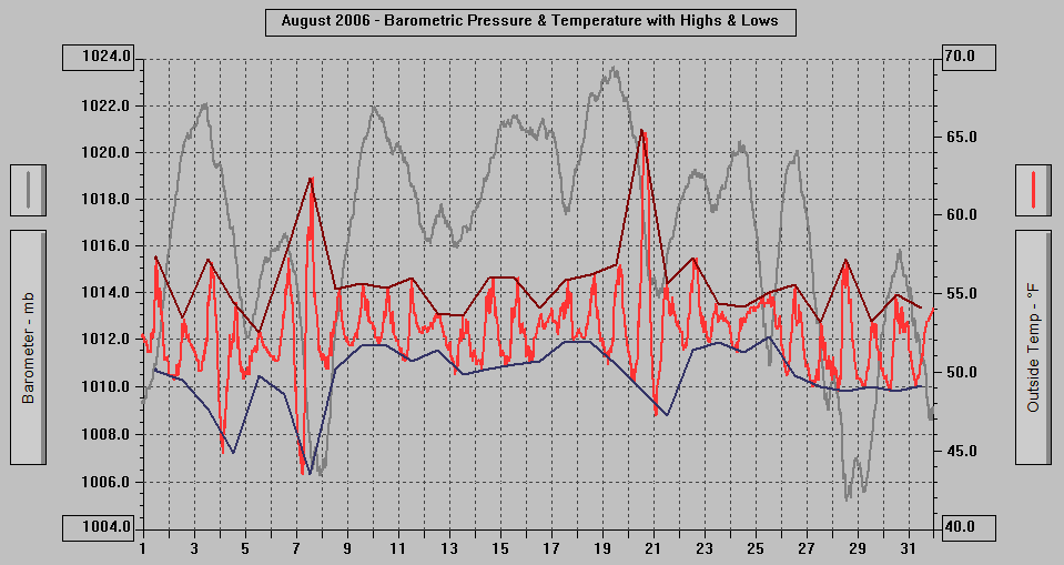
MONTHLY CLIMATOLOGICAL SUMMARY for AUGUST 2006
CONDITIONS DAY of
Month: 1 2 3 4 5 6 7 8 9 10 11 12 13 14 15 16 17 18 19 20 21 22 23 24 25 26 27 28 29 30 31
NAME: 3270 Nowell CITY: West Juneau STATE: Alaska
ELEV: 97 ft LAT: 58° 17' 33" N LONG: 134° 25' 37" W
TEMPERATURE (°F), RAIN (in), WIND SPEED (mph), SNOW (in). Snowfall from 21:00 - 21:00, all others Midnight to Midnight.
HEAT COOL AVG WIND SNOW
MEAN DEG DEG WIND DOM RUN ON(1)
DAY TEMP HIGH TIME LOW TIME DAYS DAYS RAIN SPEED HIGH TIME DIR (mi) SNOW GRND WEATHER
-----------------------------------------------------------------------------------------------------------------------------------------------------
1 52.8 57.2 12:40p 50.1 11:55p 12.2 0.0 0.11 2.1 14.0 2:30p SSE 51.61 0.0 0.0 Cldy/OccVryLtRn-Spr Cld/OccSmBrks AFewLtShrs Cld/Rn
2 51.2 53.5 2:10p 49.5 4:30a 13.8 0.0 0.31 1.6 11.0 12:35p SSE 37.92 0.0 0.0 Cld/OccRn Cldy/LtRn-Drizz-Spr-Rn & a few dry periods
3 52.4 57.2 4:45p 47.7 11:40p 12.6 0.0 0.30 0.7 10.0 10:10a E 16.29 0.0 0.0 Cld-LoClds/Rn-LtRn-Drizz-Spr Cld-OccBrks Cld DecrCld
4 50.1 54.5 3:10p 44.9 2:50a 14.9 0.0 0.46 1.3 13.0 9:30a SSE 30.54 0.0 0.0 Cldy Cld/LtRn-Spr-Rn-VryLtRn Cldy/Rain
5 51.3 52.6 1:50p 49.8 12:30a 13.7 0.0 0.86 2.3 12.0 9:55a SSE 53.98 0.0 0.0 Cld-LoClds/Rain Cld-MtntopsinClds/Rain-OccLtRn
6 52.7 57.3 4:40p 48.6 12:00m 12.3 0.0 0.14 2.1 12.0 12:40p SSE 50.59 0.0 0.0 Cld-MtntopsinClds/Rn-LtRn-Spr-Mist Cld-Brks Cldy
7 52.2 62.4 3:05p 43.5 5:45a 12.8 0.0 0.03 1.6 14.0 1:55p W 39.11 0.0 0.0 DecrCld MClr-PCld/Fog PCld Cld-PCld OvcstCld Cld/Spr
8 52.4 55.3 4:40p 50.2 4:00a 12.6 0.0 0.53 0.8 12.0 10:05a SSE 19.02 0.0 0.0 Cld-VarLwrFog-Clds/Spr-LtRn Cldy Cld/Spr-Rn-LtRn-Rn
9 53.2 55.7 2:45p 51.7 1:30a 11.8 0.0 0.10 0.7 11.0 2:25p SE 17.58 0.0 0.0 LoClds/LtRn Cld-LoClds&Cldy/PeriodsMist-Spr-LtDrizz
10 53.0 55.4 1:25p 51.7 5:30a 12.0 0.0 0.12 0.1 7.0 10:55a E 2.99 0.0 0.0 Cld-LwrClds/ExtrmLtMist-LtDrizz-Rn-Spr&PeriodsOf Cld
11 52.6 56.0 12:30p 50.7 6:00a 12.4 0.0 0.17 1.6 14.0 7:05p SSE 38.65 0.0 0.0 Cldy-MtntopsInClds LtMist Cld Cld/Mist-Spr-Rn-Drizz
12 52.9 53.8 11:00a 51.4 10:45p 12.1 0.0 0.40 2.4 13.0 2:40a SSE 56.38 0.0 0.0 Cld-MtntopsinClds-LwrClds/Rain-Drizz-LtRn-Mist-Spr
13 51.6 53.6 12:35p 49.9 5:25a 13.4 0.0 0.35 0.6 10.0 8:15a E 13.50 0.0 0.0 LoCld-Fog/Rn-Drizz VarLwrCld/Drizz-Spr-LtRn Cld LtRn
14 52.8 56.0 4:25p 50.2 6:25a 12.2 0.0 0.08 0.1 6.0 1:45p E 2.99 0.0 0.0 Fog/LtDriz Cld-PatchyFog Cld-OccSmBrk Cld/Spr-Rn Cld
15 52.5 56.0 4:00p 50.5 3:55a 12.5 0.0 0.09 0.4 6.0 9:30a E 8.71 0.0 0.0 Cld Fog Cld/Mist-Spr-LtRn-Rn Cld Sun Cld Driz Cld Rn
16 52.5 54.1 11:55p 50.7 3:05a 12.5 0.0 0.23 2.4 14.0 12:40p SSE 58.05 0.0 0.0 Cld-Fog/Drizzle Cld-LwrClds/Mist-Spr-LtDrizz-Rain
17 53.6 55.9 3:20p 52.0 8:20p 11.4 0.0 0.67 1.4 13.0 2:20p SSE 34.63 0.0 0.0 LoClds-VarLwrCld-Cld/LtRn-Drizz-Mist-Spr-Rn-HvyRn
18 53.4 56.2 4:10p 51.9 12:00m 11.6 0.0 0.32 0.9 12.0 3:30p SSE 22.51+*0.0 0.0 LoClds&Cld/LtRn-Driz-Rn-Spr-Mist Rnbow MCld Cld Shwr
19 53.3 56.9 4:30p 50.5 5:15a 11.7 0.0 0.07 0.6 12.0 1:50p E 14.48 0.0 0.0 Cld-LwrCld/Rn-LtRn-Spr Cld-OccSmBrks Cld-ThinSpots
20 55.1 65.5 4:05p 48.9 12:00m 9.9 0.0 0.00 0.5 7.0 10:45a ENE 13.03 0.0 0.0 Cldy Ovcst-Cldy Cld-Brks PCldy MCld PCld DecrCld Clr
21 52.5 55.7 12:30p 47.3 2:20a 12.5 0.0 0.13 1.1 12.0 10:00a SSE 25.54 0.0 0.0 Cld LwringClds MtntopsinClds/Spr-LtDriz-LtRn-Mist-Rn
22 53.9 57.3 1:40p 51.4 4:30a 11.1 0.0 0.11 0.9 11.0 12:50a E 21.52 0.0 0.0 LoCld-Fog/LtRn-Drizz-Mist-Rn Cld-MtntopsinCld-SmBrks
23 53.2 54.4 10:40a 51.9 4:30a 11.8 0.0 0.52 2.3 13.0 3:45p SSE 55.77 0.0 0.0 Cld Cld-MtntopsinClds-VarLwrClds/LtRn-Spr-Rn-LtDrizz
24 53.0 54.2 7:50p 51.3 6:40a 12.0 0.0 0.29 3.4 16.0 1:45p SSE 82.64 0.0 0.0 Cld-VarLwrCld/LtRn-Drizz-Mist-Spr-Rain ShowersinEve
25 54.1 55.1 1:45p 52.3 11:55p 10.9 0.0 0.64 3.8 19.0 3:55a SSE 90.67 0.0 0.0 Cld-MtntopsinClds Cld/Rn-LtRn-Spr-HvyRn Cld/OccLtRn
26 52.1 55.6 1:05p 49.8 5:10a 12.9 0.0 0.11 0.2 6.0 12:25p WSW 5.46 0.0 0.0 Cld-LwrCld/LtRn Cldy Cld/Spr-LtRn-Rn-Drizz Cldy
27 50.5 53.2 1:40p 49.1 5:40a 14.5 0.0 0.28 0.6 10.0 10:35a ENE 13.73 0.0 0.0 Cld-LwrWisps-Ribbons Cld/Shwrs Cld/Rn-LtDrizz-Mist
28 52.3 57.2 1:30p 48.8 5:50a 12.7 0.0 0.06 1.6 13.0 10:30a WNW 39.22 0.0 0.0 Cld Cld-Fog-Brks Spr PCld MCld Cld Cld/Spr-LtRn-Rn
29 50.8 53.3 1:35p 49.1 5:50a 14.2 0.0 0.13 0.9 11.0 4:40p E 22.38 0.0 0.0 Cld-LoCld/LtRn-Rn Cldy-TopsinClds MCld PCld MCld Cld
30 51.8 55.0 11:35a 48.8 6:20a 13.2 0.0 0.03 1.4 14.0 11:20p SE 33.57 0.0 0.0 Cldy Shwr Cld-TinyBrks Cld/LtRn-Mist-Spr-Driz Cldy
31 51.5 54.1 11:30p 49.2 6:25a 13.5 0.0 1.67 5.0 21.0 9:05a SSE 120.81 0.0 0.0 Cldy-VeryTopsandTopsinClds/Rain-Spr-LtRn-HvyRn Brzy
-----------------------------------------------------------------------------------------------------------------------------------------------------
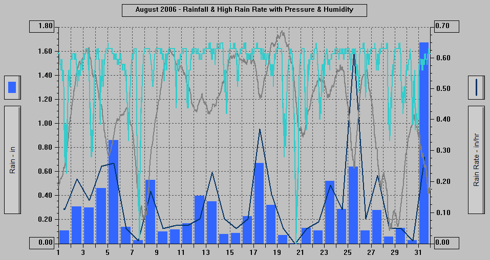
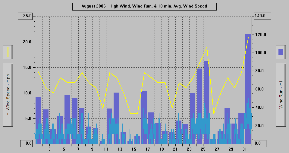
52.5 65.5 20 43.5 7 387.7 0.0 9.31 1.5 21.0 31 SSE 1093.87+*
* Anemometer not functioning 0425 - 1435 on 8/18
(1) As measured on Front Lawn
STATISTICS | DATA | GRAPHS | CONDITIONS - DAY of MONTH: 1 2 3 4 5 6 7 8 9 10 11 12 13 14 15
16 17 18 19 20 21 22 23 24 25 26 27 28 29 30 31| TOP
AVERAGE Mean Temp: 52.5
AVERAGE High Temp: 55.8
MINIMUM High Temp: 52.6 5th
MAXIMUM High Temp: 65.5 20th
AVERAGE Low Temp: 49.8
MINIMUM Low Temp: 43.5 7th
MAXIMUM Low Temp: 52.3 25th
MAX >= 90.0: 0
MAX >= 80.0: 0
MAX >= 70.0: 0
MAX <= 32.0: 0
MIN <= 32.0: 0
MIN <= 0.0: 0
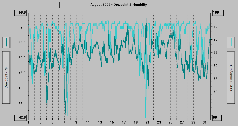
MAXIMUM Humidity (%): 97 5th, 8th, 13th, 14th, 15th, 16th, 17th, 19th, 22nd, 26th, 27th, 28th, 29th
MINIMUM Humidity (%): 60 7th @ 1423, 20th @ 1448
MAXIMUM Pressure (mb): 1023.6 19th @ 0944
MINIMUM Pressure (mb): 1005.2 28th @ 1314
TOTAL Htg Deg Days: 387.7
AVERAGE Htg Deg Days: 12.5
MINIMUM Htg Deg Days: 9.9 20th
MAXIMUM Htg Deg Days: 14.9 4th
TOTAL Cool Deg Days: 0.0
Heat Base: 65.0 Cool Base: 65.0 Method: Integration
TOTAL Precip.: 9.31
AVERAGE Precip.: 0.3
DAYS of Precip.: 30 All but: 20th
MAXIMUM Precip.: 1.67 31st
MAXIMUM Rain Rate: 0.62 25th @ 1418
Days of Rain: 30 (>.01 in) 23 (>.1 in) 1 (>1 in)
TOTAL Snowfall: 0.0
DAYS of Snowfall: 0
AVERAGE High Wind: 11.9
MINIMUM High Wind: 6 14th, 15th, 26th
MAXIMUM High Wind: 21 31st
WIND RUN (miles): 1093.87+* (See above)
DAYS Sun at any time: 6 7th, 15th, 18th, 20th, 28th, 29th
DAYS PCld at any time: 4 7th, 20th, 28th, 29th
DAYS OF Cld or M Cld: 31 All month
DAYS OF Rainbow: 1 18th @ 1705-1710
DAYS OF Aurora: 0
DAYS OF Lightning: 0
DAYS OF Earthquake: 0
- 2100 ADT: 1.52" of Rainfall to this
point today.
- 2050: Rain, Cloudy with the mountaintops
in the clouds.
- 1950: Rain, Cloudy with the mountaintops
in the clouds, inner Gold Creek valley obscured,
whitecaps on the Channel.
- 1850: Rain, Cloudy with the mountaintops
in the clouds, inner Gold Creek valley obscured,
whitecaps on the Channel.
- 1820: Rain, Cloudy with the mountaintops
in the clouds, inner Gold Creek valley obscured,
whitecaps on the Channel.
- 1800: 1.29" of Rainfall so far today.
- 1750: Light Rain, Cloudy with the mountaintops
in the clouds, inner Gold Creek valley substantially
obscured, some whitecaps on the Channel.
- 1650: Very Light Rain, Cloudy with the mountaintops
in the clouds, inner Gold Creek valley obscured,
some whitecaps on the Channel.
- 1635: Very Light Rain, Cloudy with the mountaintops
in the clouds, inner Gold Creek valley obscured,
some whitecaps on the Channel.
- 1550: Rain, Cloudy with the mountaintops
in the clouds, inner Gold Creek valley obscured,
whitecaps on the Channel.
- 1520: Very, very light sprinkling, cloudy
with the mountaintops in the clouds, inner
Gold Creek valley obscured, breezy, whitecaps
on the Channel.
- 1500: 1.24" of Rainfall so far today.
- 1450: Very Light Rain, Cloudy with the mountaintops
in the clouds, inner Gold Creek valley partially
obscured.
- 1420: Light Rain, Cloudy with mountaintops
in the clouds and a few lower wisps, inner
Gold Creek valley mostly obscured.
- 1400: 1.22" of Rainfall so far today.
- 1350: Rain, Cloudy with the mountaintops
hidden-obscured, lower band of fog/clouds
hiding Last Chance Basin and much of the
lower parts of the mainland mountains, remainder
of mainland slightly to partially obscured,
light to breezy wind.
- 1305: Rain, Cloudy with much of mainland
above 400' - 500' hidden by low clouds/fog,
breezy.
- 1250: Rain, Cloudy with the very tops and
tops of the mountains in the clouds, lower
band, wisps, and bits of fog/clouds, light
to breezy wind.
- 1200: .98" of Rainfall so far today.
- 1150: Rain, Cloudy with the very tops of
the mountains in the clouds, some lower bits
and wisps of fog/clouds, inner Gold Creek
valley partially obscured and remainder of
mainland obscured slightly.
- 1050: Rain, Cloudy with the very tops and
tops of the mountains in the clouds, some
lower bits and wisps of fog/clouds, the Channel
is getting muddy from Gold Creek.
- 1000: .76" of Rainfall so far today.
Gold Creek is running muddy.
- 0956: High Rain Rate of .28" of Rain
per hour.
- 0950: Rain, Cloudy with the very tops of
the mountains in the clouds, mainland slightly
obscured, light to breezy wind, a few small
whitecaps on the Channel.
- 0904: High Rain Rate of .26" of Rain
per hour and a 21 mph gust.
- 0900: .59" of Rainfall so far today.
- 0850: Rain, Cloudy with the very tops of
the mountains in the clouds, mainland slightly
obscured, breezy, a few small whitecaps on
the Channel.
- 0834: High Rain Rate of .25" of Rain
per hour.
- 0805: Rain, Cloudy with the very tops of
the mountains in the clouds.
- 0750: Light Rain, Cloudy with the very tops-tops
of the mountains in the clouds, breezy, some
small whitecaps on the Channel.
- 0720: Sprinkling/Very Light Rain, Cloudy
with the very tops of the mountains in the
clouds, light to breezy wind, some whitecaps
on Gastineau Channel.
- 0700: .42" of Rainfall so far today.
- 0650: Rain, Cloudy with the very tops of
the mountains in the clouds, some whitecaps
on Gastineau Channel.
- 0620 ADT: Rain, Cloudy with the very tops
of the mountains in the clouds, inner Gold
Creek valley partially to substantially obscured.
.38" of Rainfall so far today.
- 2050 ADT: Cloudy with the very tops of the
mountains in the clouds.
- 1950: Cloudy with clouds skimming Mt. Juneau
and Mt. Roberts with part of the top of Mt.
Roberts in the clouds.
- 1850: Cloudy.
- 1800: .03" of Rainfall to this point
today.
- 1750: Cloudy with a thin spot or two, a wisp
in Last Chance Basin.
- 1720: Cloudy with some tiny filtered breaks,
some bright areas in the SW part of the sky.
- 1650: Cloudy with a few tiny filtered breaks,
clouds skimming Mt. Juneau and the Mt. Juneau
Ridge.
- 1620: Cloudy with a very tiny break to the
SE, clouds skimming Mt. Juneau and Mt. Roberts,
Mt. Juneau Ridge in the clouds, a few lower
wisps.
- 1550: Very, very light misting/sprinkling,
cloudy with the very top of Mt. Juneau in
the clouds, inner Gold Creek valley obscured,
a few wisps around the top of Mt. Roberts.
- 1520: Cloudy with much of the top of Mt.
Juneau and the very tops of the Mt. Juneau
Ridge and Mt. Roberts in the clouds, a few
lower clouds in Last Chance Basin.
- 1500: .03" of Rainfall to this point
today.
- 1450: Very Light Rain (began 1447), Cloudy
with upper part of Mt. Juneau in the clouds,
and the top of Mt. Roberts and the Mt. Juneau
Ridge in the clouds.
- 1420: Cloudy with very tops and tops of the
mountains mostly in the clouds and a few
lower wisps, precipitation in the inner Gold
Creek valley.
- 1350: Light Rain, Cloudy with the mountaintops
in the clouds, inner Gold Creek valley obscured,
remainder of the mainland slightly obscured.
- 1335: Very Light Rain/Drizzle, Cloudy with
the mountaintops mostly in the clouds, inner
Gold Creek valley obscured, parts of the
remainder of the mainland slightly obscured.
- 1250: Light Sprinkling/Misting, Cloudy with
the mountaintops mostly in the clouds.
- 1220: Very, very light misting/sprinkling,
cloudy with much of the upper part of Mt.
Juneau and some of the top of Mt. Roberts
in the clouds, clouds filling much of the
inner Gold Creek valley.
- 1150: Cloudy with one tiny hint of a break,
mountaintops in the clouds, some clouds in
the inner Gold Creek valley.
- 1050: Cloudy with a few tiny hints of breaks,
top of Mt. Roberts with some lower wisps
and the upper part of Mt. Juneau hidden by
clouds, inner Gold Creek valley hidden.
- 0950: Cloudy with a few hints of breaks,
top of Mt. Roberts and much of the upper
part of Mt. Juneau hidden by clouds, inner
Gold Creek valley hidden by clouds in Last
Chance Basin.
- 0850: Cloudy with a few tiny filtered breaks,
lower fog/clouds hiding much of the upper
part of Mt. Juneau and some of the upper
part of Mt. Roberts, inner Gold Creek valley
hidden by clouds in Last Chance Basin.
- 0750: Cloudy with a tiny filtered break overhead,
a few clouds around the very tops of the
mountains with a lower band/ribbon.
- 0650: Cloudy with some tiny breaks and hints,
lower fog/clouds hiding part of Mt. Juneau,
much of Last Chance Basin, and Mt. Roberts
above 700' - 800'.
- 0630: Posted a New Weekly Picture - Sun, Mountains, Clouds & Juneau.
- 0620 ADT: Cloudy, a few thin ribbons of fog/clouds.
.01" of Rain since midnight.
- 2050 ADT: Cloudy with a few hints of breaks,
very top of Mt. Juneau in the clouds, some
clouds around the top of Mt. Roberts, Mt.
Juneau Ridge in the clouds with some lower
clouds in the inner Gold Creek valley.
- 1950: Cloudy with a few hints of blue, a
bit of clouds around the top of Mt. Roberts
and Mt. Juneau, inner Gold Creek valley hidden,
sun shining under the clouds and lighting
a few of the lower clouds and a small part
of Mt. Roberts. Sunset is at 2005 hrs.
- 1916: A Bald Eagle with 2 Northwestern Crows
in hot pursuit flew SSW over the house.
- 1905: Cloudy with tiny breaks, sun shining
under the clouds and lighting part the lowest
part of Mt. Roberts, part of the top of Mt.
Juneau and much of the top of Mt. Roberts
in the clouds, inner Gold Creek valley hidden.
- 1850: Mostly Cloudy, some clouds around the
very tops and tops of the mountains, Mt.
Juneau Ridge in the clouds, spots of sunshine
here and there on the mainland.
- 1750: Partly Cloudy SE part of sky and Cloudy
with small breaks NW part, Sun shining, clouds
hiding much of the mountaintops, inner Gold
Creek valley hidden.
- 1650: Partly/Mostly Cloudy, Sun shining off
and on, some clouds around the mountaintops,
inner Gold Creek valley hidden.
- 1635: Partly Cloudy NW 2/3rds of sky, Cloudy
SE part, Sun shining, some clouds around
the mountaintops, inner Gold Creek valley
hidden, some small whitecaps on the Channel.
- 1550: Mostly Cloudy northern part of sky,
Cloudy for the remainder with a few tiny
breaks, some clouds around the upper parts
of the mountains, inner Gold Creek valley
hidden.
- 1450: Mostly Cloudy, some fog/clouds around
the upper parts of the mountains, inner Gold
Creek valley filled with clouds, weak sunshine
here and there on the mainland mountains.
- 1350: Cloudy with some breaks in the NW part
of sky, upper parts of mainland mountains
mostly hidden by fog/clouds, inner Gold Creek
valley hidden.
- 1320: Mostly Cloudy NW part of sky, Cloudy
with tiny breaks SE part, upper parts of
mainland mountains mostly hidden by fog/clouds,
inner Gold Creek valley hidden.
- 1250: Cloudy with some small and tiny breaks,
very top of Mt. Juneau in the clouds, upper
part of Mt. Roberts mostly in the clouds,
lower band in Last Chance Basin and on the
Channel side of Mt. Juneau.
- 1235: Cloudy with a few breaks, sun broke
through briefly, very tops and tops of the
mountains in the clouds with some lower fog/clouds
on the Channel side of the mainland mountains.
- 1212: A Bald Eagle is in tree to the ENE
along the shore.
- 1150: Cloudy with the upper parts of the
mountains in the clouds and lower fog/clouds
hiding much of the lower part of the mainland
above 500'.
- 1050: Cloudy with upper parts of the mountains
in the clouds and lower ribbon/band and wisps.
- 0950: Cloudy with the upper part of Mt. Roberts,
all of Last Chance Basin, and most of Mt.
Juneau hidden by fog/clouds.
- 0850: Cloudy with Mt. Roberts hidden above
800' - 1000', all of Last Chance Basin, and
most of Mt. Juneau hidden by fog/clouds.
- 0750: Cloudy with the upper part of Mt. Roberts,
all of Last Chance Basin, and most of Mt.
Juneau hidden by fog/clouds, Blueberry Hills
in fog.
- 0700: .13" of Rainfall so far today.
- 0650: Very Light Rain, Cloudy with the upper
parts of the mountains hidden by fog/clouds,
lower fog/clouds hiding Last Chance Basin
and much of the lower part of Mt. Juneau.
- 0620 ADT: Very Light Rain, Cloudy with low
clouds/fog hiding the mainland above 100'
- 300'. .11" of Rainfall so far today.
- 2050 ADT: Very Light Rain, Cloudy with the
mountaintops in the clouds and a lower band
on the Channel side of Mt. Juneau.
- 1950: Very Light Rain, Cloudy with much of
the mountaintops in the clouds, lower band/ribbon
and wisps.
- 1850: Very Light Sprinkling, Cloudy with
the very tops of Mt. Juneau and the Mt. Juneau
Ridge in the clouds and a few wisps in the
vicinity of Cape Horn, a few clouds around
the top of Mt. Roberts.
- 1800: Trace of Rainfall to this point today.
- 1750: Cloudy with some wisps, bits, and ribbons
of fog/clouds around the upper parts of the
mountains.
- 1735: Cloudy with some wisps, bits, and ribbons
of fog/clouds around the upper parts of the
mountains.
- 1705: Very Light Sprinkling, Cloudy with
a bit of fog/clouds around the mountaintops.
- 1650: Cloudy with some wisps and bits of
fog/clouds around the mountaintops.
- 1620: Cloudy with the very top of Mt. Roberts
in the clouds, a few wisps around the Mt.
Juneau Ridge and a few wisps and bits around
the top of Mt. Juneau.
- 1550: Sprinkling/Very Light Rain, Cloudy
with the very top of Mt. Roberts in the clouds,
a few wisps around the other mountaintops.
- 1526: Sprinkling/Very Light Rain began, cloudy
with a bit of clouds around the top of Mt.
Roberts
- 1450: Cloudy.
- 1350: Cloudy, a few clouds around part of
the top of Mt. Roberts.
- 1250: Cloudy, location of the sun is visible,
a few wisps and bits of fog/clouds around
the mountaintops.
- 1200: Trace of Rainfall to this point today.
- 1150: Cloudy with a few wisps and bits of
fog/clouds around the mountaintops.
- 1135: Cloudy with a few small clouds around
the top of Mt. Juneau and Mt. Roberts.
- 1123: 2 or 3 Bald Eagles flying around.
- 1050: Cloudy/Mostly Cloudy with the breaks
in the NW part of the sky, a few clouds around
the top of Mt. Roberts and Mt. Juneau.
- 0950: Mostly/Partly Cloudy with filtered
blue sky for the most part, bright skies
with sun shining, lower band/ribbon.
- 0920: Partly Cloudy, Sun shining, lower band/ribbon
and wisps of fog/clouds.
- 0850: Very Light Sprinkling, Cloudy with
the sun shining and bright clouds to the
E, tiny breaks to the ENE and E, lower band/ribbon
and bits of fog/clouds.
- 0810: Sprinkling, Sun is shining.
- 0808: The Sun is breaking through the clouds
and at 0810 full strength.
- 0750: Cloudy with small breaks, fog over
the Channel variably hiding the mainland,
fog in the upper parts of West Juneau.
- 0720: Cloudy with a few hints of blue, thin
layer of fog lying low over the waters of
Gastineau Channel.
- 0650: Cloudy with hints of blue and a small
filtered break.
- 0620: Cloudy with hints of blue.
- 0513 ADT: First Steller's Jay of the day
arrived.
SUNDAY 8/27/06: DATA
- 2100 ADT: .26" of Rainfall so far today.
- 2050: Very Light Misting/Sprinkling, Cloudy
with clouds skimming Mt. Juneau and some
clouds on the Channel side of the top of
Mt. Roberts, lower fog/clouds on Channel
side of Mt. Juneau.
- 1950: Light Drizzle, Cloudy with a few lower
wisps.
- 1850: Rain, Cloudy with a variable lower
band hiding all but the very tops and bottoms
of the mainland mountains. .22" of Rainfall
so far today.
- 1839: High Rain Rate of .22" of Rain
per hour.
- 1820: Rain, Cloudy with some fog/clouds on
the Channel side of the mountaintops.
- 1800: .11" of Rainfall so far today.
- 1750: Light Misting/Drizzle, Cloudy with
clouds skimming Mt. Roberts and a cloud on
the Channel side, a lower ribbon on the Channel
side of Mt. Juneau and a cloud by the Mt.
Juneau Ridge.
- 1650: Rain, Cloudy with a lower ribbon and
a few wisps.
- 1635: Cloudy with a thin lower ribbon.
- 1620: Rain, Cloudy with a lower ribbon.
- 1550: Cloudy with a lower ribbon and a few
wisps.
- 1520: Light Sprinkling, Cloudy with a lower
ribbon.
- 1500: .08" of Rainfall so far today.
- 1450: Cloudy, a few lower wisps, precipitation
over top of Mt. Roberts and in the inner
Gold Creek valley.
- 1420: Cloudy with a large cloud on the south
side of Mt. Juneau and a few wisps.
- 1350: Rain, Cloudy with a few lower wisps.
- 1250: Light Rain, Cloudy with some lower
wisps, band of clouds on Channel side of
Mt. Juneau near the top.
- 1200: .02" of Rainfall so far today.
- 1150: Light Rain, Cloudy with clouds skimming
the Mt. Juneau Ridge, a few lower wisps,
location of the sun is visible.
- 1120: Light Rain, Cloudy with a few lower
wisps.
- 1050: Rain, Cloudy with clouds skimming Mt.
Roberts, band on Channel side of Mt. Juneau
at the top, and a cloud in Last Chance Basin.
- 1035: Sprinkling, Cloudy with lower ribbons,
band, and wisps.
- 0950: Cloudy with lower ribbon.
- 0850: Cloudy, some wisps in Last Chance Basin.
- 0750: Cloudy, a lower ribbons and a few wisps
(they come and go).
- 0650: Cloudy with a few lower wisps.
- 0620 ADT: Cloudy with lower ribbons and wisps
and patches of very thin fog.
- 2050 ADT: Cloudy with hints of breaks.
- 1950: Cloudy with a few wisps in Last Chance
Basin.
- 1850: Cloudy with clouds skimming Mt. Juneau
and Mt. Roberts, very top of the Mt. Juneau
Ridge in the clouds.
- 1800: .11" of Rainfall to this point
today.
- 1750: Cloudy with clouds skimming the mountaintops,
a few lower wisps.
- 1650: Cloudy with the clouds skimming the
mountaintops in the clouds, some lower fog/clouds
around the mountains
- 1550: Cloudy with the very top of Mt. Juneau
and top of the Mt. Juneau Ridge in the clouds,
some clouds around the top of Mt. Roberts,
a few lower wisps, some precipitation in
the inner Gold Creek valley.
- 1503: .09" of Rainfall so far today.
- 1450: Rain, Cloudy with the upper parts of
the mountains in the clouds, inner Gold Creek
valley hidden, remainder of mainland slightly
obscured.
- 1350: Rain/Drizzle, Cloudy with the upper
parts of the mountains in the clouds, inner
Gold Creek valley hidden, remainder of mainland
slightly obscured.
- 1320: Sprinkling/Very Light Rain, Cloudy
with the mountaintops mostly in the clouds,
inner Gold Creek valley hidden by clouds.
- 1250: Cloudy with very, very tops of mountains
in the clouds or clouds skimming, a few lower
wisps, scattered light precipitation over
the mainland during the past 50 minutes.
- 1157: Rain Shower, Cloudy with the top of
Mt. Juneau hidden, clouds around much of
the top of Mt. Roberts, a few lower wisps.
- 1200: .02" of Rainfall so far today.
- 1150: Cloudy with some fog/clouds around
the mountaintops a few lower fog/clouds and
wisps in Last Chance Basin.
- 1050: Cloudy with bright spots, very top
of Mt. Juneau and top of Mt. Juneau Ridge
in the clouds, fog/clouds around the upper
part of Mt. Roberts, some clouds in Last
Chance Basin.
- 0950: Cloudy with the mountaintops in the
clouds, lower band, precipitation over Mt.
Juneau.
- 0850: Extremely Light Sprinkles, Cloudy with
the mountaintops in the clouds, lower ribbons/band
of fog/clouds.
- 0750: Cloudy with the top of Mt. Juneau and
Mt. Roberts in the clouds, clouds skimming
a high point on the Mt. Juneau Ridge, a few
lower wisps.
- 0650: Cloudy with some clouds around the
very top of Mt. Juneau and top of Mt. Roberts,
lower band/ribbon of fog/clouds.
- 0620 ADT: Cloudy with some thin spots and
hints of breaks, top of Mt. Juneau hidden,
lower band/ribbons of fog/clouds. .01"
of Rainfall to this point today.
- 2100 ADT: .61" of Rainfall so far today.
- 2050: Cloudy with the mountaintops in the
clouds.
- 1950: Cloudy with the mountaintops in the
clouds.
- 1850: Light Rain, Cloudy with the mountaintops
in the clouds, a few lower wisps.
- 1820: Light Rain/Drizzle, Cloudy with the
mountaintops in the clouds, inner Gold Creek
valley substantially obscured, remainder
of mainland slightly obscured, much of the
Channel opposite Gold Creek is still muddy
and is spreading with the currents as the
tide is going out.
- 1800: .58" of Rainfall so far today.
- 1750: Cloudy with the mountaintops in the
clouds, a lower wisp in Last Chance Basin.
- 1720: Light Misting/Sprinkling, Cloudy with
the mountaintops mostly in the clouds, much
of the Channel opposite Gold Creek is still
muddy.
- 1650: Cloudy with the mountaintops in the
clouds, a few lower wisps.
- 1550: Light Sprinkling, Cloudy with some
clouds around the upper parts of the mountains
and in Last Chance Basin. Gastineau Channel
is very muddy off the mouth of Gold Creek,
the mud spreads all the way to Douglas Island.
- 1505: Rain, Cloudy with the mountaintops
in the clouds.
- 1500: .55" of Rainfall so far today.
- 1450: Heavy Rain, Cloudy with the mountaintops
in the clouds, mainland partially obscured,
inner Gold Creek valley hidden.
- 1435: Heavy Rain after Rain, Cloudy with
the upper parts of the mountains in the clouds,
inner Gold Creek valley substantially obscured,
remainder of mainland partially to substantially
obscured.
- 1420: Heavy Rain, Cloudy with the mountaintops
in the clouds, mainland hidden by fog/mists.
- 1418: High Rain Rate of .62" of Rain
per hour.
- 1415: High Rain Rate of .40" of Rain
per hour.
- 1350: Heavy Rain, Cloudy with the mountaintops
in the clouds - ceiling at about 1500' at
Mt. Roberts, some whitecaps on the Channel,
inner Gold Creek valley obscured
- 1335: Light Rain after heavier rain, cloudy
with the upper parts of the mountains in
the clouds, inner Gold Creek valley substantially
obscured, some whitecaps on the Channel.
- 1250: Very Light Rain/Sprinkling, Cloudy
with the upper parts of the mountains in
the clouds, inner Gold Creek valley substantially
obscured, whitecaps on part of the Channel.
- 1200: .24" of Rainfall so far today.
- 1150: Very Light Rain/Misting, Cloudy with
the upper parts of the mountains in the clouds,
inner Gold Creek valley substantially obscured,
whitecaps on the Channel.
- 1120: Very Light Rain/Misting, Cloudy with
the upper parts of the mountains in the clouds.
- 1050: Cloudy with the mountaintops in the
clouds - ceiling at about 1400' at Mt. Roberts.
- 1020: Very, very light sprinkling, cloudy
with the mountaintops in the clouds, some
small whitecaps on the Channel. .23"
of Rainfall so far today.
- 0950: Rain, Cloudy with the mountaintops
in the clouds, some small whitecaps on the
Channel. .21" of Rainfall so far today.
- 0850: Rain, Cloudy with the mountaintops
in the clouds, a few small whitecaps on the
Channel, inner Gold Creek valley obscured,
remainder of mainland slightly to partially
obscured.
- 0750: Rain, Cloudy with the mountaintops
in the clouds, some small whitecaps on the
Channel, inner Gold Creek valley substantially
obscured.
- 0730: Rain, Cloudy with the mountaintops
in the clouds, some small whitecaps on the
Channel, inner Gold Creek valley partially
obscured.
- 0650: Cloudy with the mountaintops and upper
parts in the clouds, precipitation over the
mainland, small whitecaps on Gastineau Channel.
- 0620 ADT: Cloudy with the mountaintops in
the clouds, precipitation in the inner Gold
Creek valley, light to breezy wind. .02"
of Rainfall to this point today.
- 2050 ADT: Very Light Rain, Cloudy with the
upper parts of the mountains in the clouds,
inner Gold Creek valley obscured.
- 1950: Rain, Cloudy with the mountaintops
in the clouds, a few lower wisps.
- 1920: Cloudy with the mountaintops in the
clouds, inner Gold Creek valley partially
obscured.
- 1850: Very Light Rain/Drizzle, Cloudy with
the mountaintops in the clouds and a few
lower wisps, inner Gold Creek valley partially
obscured.
- 1800: .24" of Rainfall so far today.
- 1750: Light Rain, Cloudy with the top of
Mt. Roberts in the clouds, upper part of
Mt. Juneau in the clouds with lower fog/clouds,
Last Chance Basin partially hidden, remainder
of mainland partially obscured.
- 1650: Cloudy with the mountaintops in the
clouds, lower band in Last Chance Basin and
on the Channel side of Mt. Juneau.
- 1635: Rain, Cloudy with the mountaintops
in the clouds, some lower wisps and bits
of fog/clouds, inner Gold Creek valley hidden,
remainder of mainland slightly to partially
obscured.
- 1620: Very Light Sprinkling/Misting, Cloudy
with the mountaintops in the clouds, some
lower wisps and bits of fog/clouds, inner
Gold Creek valley obscured.
- 1550: Rain-Drizzle, Cloudy with the mountaintops
in the clouds, inner Gold Creek valley hidden,
remainder of mainland slightly to partially
obscured.
- 1500: .19" of Rainfall so far today.
- 1450: Extremely Light Misting (barely detectable),
Cloudy with the mountaintops in the clouds
and a lower ribbon and wisps, light to breezy
wind.
- 1350: Drizzle, Cloudy with the mountaintops
in the clouds, inner Gold Creek valley hidden,
remainder of mainland partially to substantially
obscured, light to breezy wind.
- 1320: Rain, Cloudy with the mountaintops
in the clouds, inner Gold Creek valley hidden,
remainder of mainland partially to substantially
obscured.
- 1250: Light Drizzle/Rain, Cloudy with the
mountaintops in the clouds, inner Gold Creek
valley hidden, remainder of mainland slightly
to partially obscured.
- 1220: Rain, Cloudy with the mountaintops
in the clouds and some lower fog/clouds,
remainder of mainland slightly to partially
obscured.
- 1200: .09" of Rainfall so far today.
- 1150: Very Light Rain/Drizzle, Cloudy with
the mountaintops in the clouds and a few
lower bits and wisps, inner Gold Creek valley
hidden, remainder of mainland slightly to
partially obscured.
- 1050: Light Drizzle, Cloudy with the upper
part of Mt. Roberts and Mt. Juneau in the
clouds and lower band, Last Chance Basin
hidden by fog/clouds.
- 0950: Very, very light sprinkling, cloudy
with the top of Mt. Roberts in the clouds
and lower fog/clouds, much of Mt. Juneau
and Last Chance Basin hidden by fog/clouds.
- 0850: Very Light Misting/Sprinkling, Cloudy
with the mountaintops in the clouds and lower
band and wisps of fog/clouds.
- 0750: Extremely Light Misting, Cloudy with
the top of Mt. Roberts in the clouds and
lower wisps, fog/clouds hiding most of Mt.
Juneau and Last Chance Basin.
- 0700: .05" of Rainfall so far today.
- 0650: Extremely Light Sprinkling, Cloudy
with fog/clouds hiding most of the mainland
above 300' - 400'.
- 0620 ADT: Very, very light misting, cloudy
with the top of Mt. Roberts in the clouds
and lower band hiding much of lower part,
fog/clouds hiding most of Mt. Juneau and
Last Chance Basin.
8/23/06: DATA | First day of School
- 2100 ADT: .49" of Rainfall so far today.
- 2050: Very Light Rain/Misting-Drizzle, Cloudy
with the top of Mt. Roberts in the clouds
and lower band, fog/clouds hiding most of
Mt. Juneau and Last Chance Basin, remainder
of mainland slightly obscured.
- 1950: Extremely Light Sprinkling, Cloudy
with the top of Mt. Roberts in the clouds
and lower band, fog/clouds hiding most of
Mt. Juneau and Last Chance Basin.
- 1920: Extremely Light Sprinkling, Cloudy
with the top of Mt. Roberts in the clouds
and lower band, fog/clouds hiding most of
Mt. Juneau and Last Chance Basin.
- 1850: Light Rain, Cloudy with the mountaintops
in the clouds and lower band/ribbon.
- 1800: .45" of Rainfall so far today.
- 1750: Rain, Cloudy with the top of Mt. Roberts
in the clouds and lower wisps, fog/clouds
hiding most of Mt. Juneau and Last Chance
Basin, remainder of the mainland slightly
obscured.
- 1720: Rain, Cloudy with the top of Mt. Roberts
in the clouds and lower bands, fog/clouds
hiding most of Mt. Juneau and Last Chance
Basin, remainder of the mainland slightly
to partially obscured.
- 1650: Light Misting/Drizzle, Cloudy with
the top of Mt. Roberts in the clouds and
lower bands, fog/clouds hiding most of Mt.
Juneau and Last Chance Basin, remainder of
the mainland slightly obscured.
- 1620: Light Drizzle/Sprinkling, Cloudy with
low clouds/fog hiding most of the mainland
above about 300' - 400'.
- 1550: Light Sprinkling, Cloudy with the top
of Mt. Roberts in the clouds, fog/clouds
hiding most of Mt. Juneau and Last Chance
Basin, parts of the remainder of the mainland
slightly obscured.
- 1500: .26" of Rainfall so far today.
- 1450: Rain, Cloudy with the top of Mt. Roberts
in the clouds, fog/clouds hiding most of
Mt. Juneau and Last Chance Basin, remainder
of mainland slightly to partially obscured.
- 1405: Rain, Cloudy with the top of Mt. Roberts
in the clouds, fog/clouds hiding most of
Mt. Juneau and Last Chance Basin, remainder
of mainland partially obscured.
- 1350: Very Light Rain, Cloudy with the top
of Mt. Roberts in the clouds, fog/clouds
hiding most of Mt. Juneau and some clouds
in Last Chance Basin, inner Gold Creek valley
hidden.
- 1320: Very Light Rain/Sprinkling, Cloudy
with the mountaintops in the clouds and some
lower fog/clouds on the Channel side of Mt.
Juneau.
- 1305: Light Rain, Cloudy with the mountaintops
in the clouds and a few lower wisps.
- 1250: Rain, Cloudy with the mountaintops
in the clouds and a few lower wisps.
- 1220: Rain, Cloudy with the mountaintops
in the clouds and a few lower wisps.
- 1212: High Rain Rate of .19" of Rain
per hour.
- 1200: .20" of Rainfall so far today.
- 1150: Rain, Cloudy with the top of Mt. Roberts
in the clouds, fog/clouds hiding most of
Mt. Juneau and some clouds in Last Chance
Basin, inner Gold Creek valley hidden.
- 1050: Rain, Cloudy with the mountaintops
in the clouds, lower bands, ribbons, and
wisps of fog/clouds.
- 0950: Rain, Cloudy with the mountaintops
in the clouds, lower bands, ribbons, and
wisps of fog/clouds - mostly in Last Chance
Basin and on the Channel side of Mt. Juneau.
- 0920: Rain, Cloudy with the mountaintops
in the clouds, a few lower wisps and ribbons
of fog/clouds, inner Gold Creek valley hidden,
remainder of mainland slightly to partially
obscured.
- 0850: Light Rain, Cloudy with the mountaintops
in the clouds, a few lower wisps and bits
of fog/clouds, remainder of mainland slightly
obscured.
- 0750: Light Rain, Cloudy with the mountaintops
in the clouds, a few lower wisps and bits
of fog/clouds.
- 0700: .01" of Rainfall so far today.
- 0650: Light Rain, Cloudy with the upper parts
of the mountains in the clouds, some lower
wisps and bits of fog/clouds, inner Gold
Creek valley hidden.
- 0630: Posted a New Weekly Picture - The Last Chance Basin side of Mt. Juneau
with Mists & Clouds
- 0620 ADT: Very Light Rain/Sprinkling, Cloudy
with the mountaintops in the clouds and a
few lower wisps.
8/22/06: DATA | State Primary Election: Polls open 7 a.m.
to 8 p.m.
- 2050 ADT: Cloudy with the very tops and tops
of the mountains in the clouds.
- 1950: Cloudy with a small break, mountaintops
in the clouds.
- 1920: Cloudy with the mountaintops in the
clouds and one or two very tiny filtered
breaks.
- 1850: Extremely Light Misting/Sprinkling,
Cloudy with the mountaintops in the clouds
and a few lower wisps, much of the remainder
of the mainland slightly obscured.
- 1750: Cloudy with the mountaintops in the
clouds, a few lower clouds in the inner Gold
Creek valley and Last Chance Basin.
- 1720: Cloudy with the mountaintops in the
clouds, precipitation to the E over Mt. Roberts.
- 1650: Cloudy with the mountaintops in the
clouds, some lower clouds in the inner Gold
Creek valley.
- 1550: Cloudy with very top of Mt. Juneau
and top of Mt. Roberts in the clouds, a few
lower wisps, rain far to the ESE over part
of Mt. Roberts, fog/clouds hiding the inner
Gold Creek valley.
- 1450: Cloudy with much of the very tops-tops
of the mountains in the clouds and a few
lower wisps over the Channel slope of Mt.
Roberts, fog/clouds hiding the inner Gold
Creek valley.
- 1420: Cloudy with much of the mountaintops
in the clouds and some lower wisps over the
Channel slope of Mt. Roberts, rain to the
ESE over part of Mt. Roberts, fog/clouds
hiding the inner Gold Creek valley.
- 1350: Cloudy with much of the mountaintops
in the clouds and some lower wisps over the
Channel slope of Mt. Roberts, fog/clouds
hiding the inner Gold Creek valley.
- 1320: Cloudy with bright areas, location
of sun visible, a few tiny filtered breaks,
tops-very tops of mountains mostly in the
clouds with lower band, much of Last Chance
Basin hidden.
- 1250: Cloudy with bright spots, much of the
upper parts of the mountains hidden by
fog/clouds,
much of Last Chance Basin hidden.
- 1150: Very, very light sprinkling, cloudy
with the upper part of Mt. Roberts in the
clouds with some lower fog/clouds on the
Channel side, fog/clouds hiding much of
Mt.
Juneau (part of the top visible) and much
of Last Chance Basin.
- 1120: Light Drizzle, Cloudy with the top
of Mt. Roberts in the clouds with some
lower
fog/clouds on the Channel side, fog/clouds
hiding much of Mt. Juneau and all of Last
Chance Basin.
- 1050: Cloudy with mountaintops mostly in
the clouds and a lower band and wisps.
- 0950: Very very light misting, cloudy with
the top of Mt. Roberts in the clouds with
some lower fog/clouds on the Channel side,
fog/clouds hiding most of Mt. Juneau and
all of Last Chance Basin.
- 0850: Cloudy with the upper part of Mt. Roberts
in the clouds with some lower fog/clouds
over the Channel slope, fog/clouds hiding
most of Mt. Juneau and all of Last Chance
Basin.
- 0750: Very, very light misting/sprinkling,
cloudy with the mainland mostly hidden
by
low clouds/fog above 200' - 300', slightly
obscured below that.
- 0735: Very, very light misting/sprinkling,
cloudy with the mainland hidden by low
clouds/fog
above 100' - 200'.
- 0700: .10" of Rainfall so far today.
- 0650: Rain, Cloudy with Fog.
- 0620 ADT: Very Light Misting/Sprinkling,
Cloudy with low fog/clouds hiding the mainland
above 100' - 200' and partially obscured
below that, Blueberry Hills and upper part
of Pioneer Avenue in fog. .08" of
Rainfall
so far today.
- 2100 ADT: .09" of Rainfall to this point
today.
- 2050: Drizzle/Rain, Cloudy with the mountaintops
in the clouds, a few lower wisps.
- 2020: Drizzle/Rain, Cloudy with the mountaintops
in the clouds, mainland slightly to partially
obscured.
- 1950: Light Drizzle, Cloudy with the mountaintops
in the clouds, mainland slightly to partially
obscured.
- 1905: Light Rain, Cloudy with the mountaintops
in the clouds.
- 1850: Very, very light misting, sprinkling,
cloudy with the mountaintops in the clouds
and a few lower fog/clouds, parts of the
mainland slightly obscured, inner Gold Creek
valley hidden.
- 1800: .03" of Rainfall so far today.
- 1750: Extremely Light Misting/Sprinkling,
Cloudy with the mountaintops in the clouds
and some lower fog/clouds, bands, and wisps,
inner Gold Creek valley hidden.
- 1720: Very, very light sprinkling, cloudy
with the mountaintops in the clouds, a lower
band of fog/clouds.
- 1650: Light Rain, Cloudy with the mountaintops
in the clouds, some lower bits and wisps
in Last Chance Basin and on the Channel side
of Mt. Juneau, mainland slightly obscured,
inner Gold Creek valley partially obscured.
- 1620: Very Light Rain/Drizzle, Cloudy with
the mountaintops in the clouds, mainland
slightly obscured, inner Gold Creek valley
hidden.
- 1550: Cloudy with the mountaintops in the
clouds, a few lower fog/clouds in Last Chance
Basin and on the Channel side of Mt. Juneau.
- 1500: .01" of Rainfall so far today.
- 1450: Cloudy with the very tops and tops
of the mountains in the clouds, a few lower
wisps and bits of fog/clouds..
- 1420: Very Light Drizzle, Cloudy with the
mountaintops in the clouds and mainland slightly
obscured, lower ribbon/band on the Channel
side of Mt. Juneau, inner Gold Creek valley
hidden.
- 1405: Light Drizzle, Cloudy with the mountaintops
in the clouds and mainland slightly to partially
obscured, inner Gold Creek valley hidden.
- 1350: Sprinkling/Very Light Rain, Cloudy
with the mountaintops in the clouds.
- 1335: Very Light Rain/Sprinkling, Cloudy
with the mountaintops in the clouds.
- 1316: Very Light Sprinkling began, Cloudy
with the mountaintops in the clouds.
- 1250: Cloudy with the mountaintops in the
clouds.
- 1150: Cloudy with the mountaintops in the
clouds.
- 1050: Cloudy with the upper parts of the
mountains in the clouds, inner Gold Creek
valley mostly hidden.
- 0950: Cloudy with the very top of Mt. Juneau
and Mt. Roberts in the clouds with a lower
ribbon on the Channel side of Mt. Juneau,
Mt. Juneau Ridge in the clouds.
- 0920: Cloudy with the very tops of the mountains
in the clouds.
- 0850: Cloudy with some fog/clouds around
the very top of Mt. Juneau and Mt. Roberts.
- 0835: Cloudy with very top of Mt. Juneau
and part of the top of Mt. Roberts in the
clouds.
- 0750: Cloudy.
- 0735: Cloudy, precipitation over part of
Mt. Roberts, top of Olds Mountain in the
clouds.
- 0650: Cloudy.
- 0620 ADT: Cloudy with a few tiny hints of
blue.
SUNDAY 8/20/06: DATA
- 2050 ADT: Clear.
- 1950: Clear with a tiny bit of high very
thin clouds.
- 1920: Clear with a few very thin tiny clouds
in NW part, very far to the NW there is some
cloud cover.
- 1850: Mostly Clear SE 1/3rd of sky, Partly/Mostly
Cloudy NW 2/3rds, sun shining.
- 1750: Partly Cloudy, spots of weakened sunshine
on parts of the mainland, sun has been shining
here occasionally in latter half of afternoon.
- 1650: Mostly Cloudy, spots of weakened sunshine
on parts of the mainland.
- 1550: Mostly Cloudy, weak sunshine on parts
of the mainland.
- 1450: Partly Cloudy with weak sunshine on
parts of the mainland.
- 1350: Cloudy for most of the sky with small
breaks, partly cloudy and clear sky to the
ESE, very weak sunshine.
- 1320: Mostly/Partly Cloudy with bright skies,
weak sunshine.
- 1250 Cloudy with breaks and bright skies.
- 1150: Cloudy with bright skies, a few hints
of breaks and a few very tiny breaks.
- 1050: Cloudy with bright clouds in the SE
part of the sky.
- 1042-1046: A Steller's Jay took a bath in
the Bird Bath.
- 0950: Cloudy with a partly broken area and
bright spots.
- 0850: Cloudy-Overcast, tiny cloud in Last
Chance Basin.
- 0837-0839: A Steller's Jay took a bath in
the Bird Bath.
- 0750: Cloudy-Overcast, occasional thin lower
ribbons and wisps.
- 0650: Overcast-Cloudy.
- 0620 ADT: Overcast-Cloudy.
8/19/06: DATA | The Fireweed has finished blooming
- 2050 ADT: Cloudy with some hints of blue
in thinner areas.
- 1950: Cloudy with thinner spots in the SE
part of the sky where there are hints of
blue, clouds skimming the high points of
Mt. Juneau and the Mt. Juneau Ridge.
- 1850: Cloudy with a small break far to the
SE, clouds skimming high points of the mainland
mountains.
- 1750: Cloudy with a few tiny breaks in the
eastern part of the sky, peak of Mt. Juneau
and high points of the Mt. Juneau Ridge and
part of the top of Mt. Roberts in the clouds.
- 1650: Cloudy with small breaks, a bit of
fog/clouds around the top of Mt. Juneau and
Mt. Roberts.
- 1550: Cloudy with a few very small breaks,
some fog/clouds around the mountaintops.
- 1450: Cloudy with the very top of the Mt.
Juneau Ridge mostly in the clouds, a bit
of fog/clouds around the top of Mt. Juneau
and Mt. Roberts, very tiny break to the E.
- 1420: Cloudy with a slightly broken area
in the SE part of the sky, very top of Mt.
Juneau and the Mt. Juneau Ridge in the clouds.
- 1350: Cloudy with the top of Mt. Juneau and
very top of Mt. Juneau Ridge mostly in the
clouds, some clouds hiding part of the top
of Mt. Roberts, a bit of precipitation over
part of Mt. Roberts; in the past hour there
has been precipitation in the inner Gold
Creek valley.
- 1250: Cloudy with a few clouds around the
very tops and tops of the mountains.
- 1200: .07" of Rainfall to this point
today.
- 1150: Cloudy with a few breaks, some clouds
around the mountaintops.
- 1050: Cloudy with some small, very small
breaks, a few lower ribbons, bits and wisps.
- 1020: Cloudy with a few filtered breaks,
bright spots, lower ribbon/band of fog/clouds.
- 0950: Cloudy with some fog/clouds in the
inner Gold Creek valley, lower band of fog/clouds
in Last Chance Basin and on the Channel side
of Mt. Juneau, a few other wisps on Channel
side of Mt. Roberts.
- 0850: Cloudy with very top of Mt. Juneau
Ridge and very top and part of the top of
Mt. Roberts in the clouds, ribbon of fog/clouds
in Last Chance Basin and on the Channel side
of Mt. Juneau.
- 0820: Cloudy with very top of Mt. Juneau
and Mt. Roberts in the clouds and a lower
band.
- 0751: A Bald Eagle is gliding NW over the
shore.
- 0750: Extremely Light Sprinkling, Cloudy
with the mountaintops in the clouds and some
lower fog/clouds and band/ribbon.
- 0700: .06" of Rainfall to this point
today.
- 0650: Sprinkling/Very Light Rain, Cloudy
with most of the mainland above 400' - 500'
hidden by fog/clouds.
- 0620 ADT: Rain, Cloudy with very top of Mt.
Roberts and part of it's top in the clouds,
Mt. Juneau and Last Chance Basin hidden.
8/18/06: DATA | Anemometer not functioning 0425 - 1435
| Record Rainfall of 1.11" for August
17 at the Juneau Airport, Exceeded the previous
record of 1.08" set in 1952
- 2100 ADT: .32" of Rainfall to this point
today.
- 2050: Cloudy with a few hints of breaks,
very top of Mt. Roberts in the clouds, fog/clouds
in Last Chance Basin, part of Mt. Juneau
hidden.
- 1950: Cloudy with the very top of Mt. Roberts
in the clouds, much of the upper part of
Mt. Juneau and much of Last Chance Basin
hidden.
- 1850: Rain, Cloudy with the top of Mt. Roberts
in the clouds and a few lower wisps, much
of Mt. Juneau, and all of Last Chance Basin
hidden.
- 1820: Sprinkling/Very Light Rain, Cloudy
with very tops of mountains in the clouds,
lower band of fog/clouds in Last Chance Basin
and on Channel side of Mt. Juneau.
- 1800: .27" of Rainfall so far today.
- 1750: Cloudy with very tops of mountains
in the clouds, Mt. Juneau Ridge in the clouds,
lower band of fog/clouds.
- 1720: Mostly Cloudy, spots of sunshine here
and there, some fog/clouds around the mountains
and in Last Chance Basin.
- 1706: Faint full Rainbow to the ENE, disappeared
at 1710.
- 1650: Rain, Cloudy with some clouds around
part of the top of Mt. Roberts, upper part
of Mt. Juneau hidden, some fog/clouds in
Last Chance Basin, inner Gold Creek valley
hidden, remainder of mainland slightly hidden.
- 1635: Very, very light misting, cloudy with
the upper parts of the mountains in the clouds,
some fog/clouds in Last Chance Basin hiding
the inner Gold Creek valley.
- 1550: Cloudy with the upper parts of the
mountains mostly in the clouds and fog/clouds
in much of Last Chance Basin.
- 1522: Weak sunshine on the lower part of
Mt. Roberts in the vicinity of the Cruise
Ship Terminal.
- 1500: .25" of Rainfall so far today.
- 1450: Light Rain then Rain, Cloudy with the
top of Mt. Roberts and upper part of Mt.
Juneau in the clouds, some clouds in Last
Chance Basin hiding the inner Gold Creek
valley.
- 1435: Anemometer functional again, I think
I have "fixed" the problem but
time will tell.
- 1350: Very Light Misting, Cloudy with some
fog/clouds around Mt. Roberts, much of Mt.
Juneau and all of Last Chance Basin hidden.
- 1305: Light Rain, Cloudy with some fog/clouds
around Mt. Roberts, much of Mt. Juneau and
all of Last Chance Basin hidden.
- 1150: Rain, Cloudy with the top of Mt. Roberts
and upper part of Mt. Juneau in the clouds,
inner Gold Creek valley hidden, a few clouds
in Last Chance Basin and lower wisps, remainder
of mainland slightly obscured.
- 1145: High Rain rate of .16" of Rain
per hour.
- 1135: Light Rain, Cloudy with the top of
Mt. Roberts and upper part of Mt. Juneau
in the clouds, inner Gold Creek valley hidden,
a few clouds in Last Chance Basin and lower
wisps and bits of fog/clouds.
- 1105: Very Light Sprinkling, with the top
of Mt. Roberts and upper part of Mt. Juneau
in the clouds, inner Gold Creek valley hidden,
a few clouds in Last Chance Basin.
- 1050: Cloudy with the mountaintops in the
clouds, a few lower wisps, a cloud in Last
Chance Basin hiding the inner Gold Creek
valley.
- 0950: Cloudy with the top of Mt. Roberts
and upper part of Mt. Juneau in the clouds,
inner Gold Creek valley hidden, a few clouds
in Last Chance Basin.
- 0935: Very Light Rain, Cloudy with the top
of Mt. Roberts in the clouds, most of Mt.
Juneau hidden and all of the inner Gold Creek
valley, some clouds in Last Chance Basin.
- 0850: Very, very light sprinkling, cloudy
with the top of Mt. Roberts in the clouds
and lower wisps, most of Mt. Juneau, and
all of Last Chance Basin hidden.
- 0750: Rain (began 0745), Cloudy with the
top of Mt. Roberts and upper part of Mt.
Juneau in the clouds, inner Gold Creek valley
mostly hidden, some lower wisps and bits.
- 0700: .12" of Rainfall to this point
today.
- 0650: Cloudy with the top of Mt. Roberts
in the clouds and lower ribbon/band, most
of Mt. Juneau, and all of Last Chance Basin
hidden.
- 0635: Rain, Cloudy with the top of Mt. Roberts
in the clouds and lower wisps, most of Mt.
Juneau, and all of Last Chance Basin hidden.
- 0620: Light Rain, Cloudy with the top of
Mt. Roberts in the clouds, most of Mt. Juneau,
and all of Last Chance Basin hidden.
- 0425 ADT: Anemometer ceased functioning.
8/17/06: DATA | Record Rainfall of 1.11" for today
at the Juneau Airport, exceeding the previous
record of 1.08" set in 1952 | This is
the 19th consecutive day of .01" of
rain or more per day.
- Midnight: 67" of Rainfall for August
17.
- 2100 ADT: .62" of Rainfall to this point
today.
- 2050: Light Rain, Cloudy with the upper parts
of the mountains in the clouds.
- 2020: Light Rain, Cloudy with the upper parts
of the mountains in the clouds.
- 1950: Rain, Cloudy with the mountaintops
in the clouds, inner Gold Creek valley hidden,
remainder of mainland slightly obscured.
- 1937: High Rain Rate of .37" of Rain
per hour.
- 1920: Rain, Cloudy with the top of Mt. Roberts
in the clouds and lower wisps, most of Mt.
Juneau, and all of Last Chance Basin hidden.
- 1850: Light Rain, Cloudy with very top and
part of the top of Mt. Roberts in the clouds
and lower wisps, most of Mt. Juneau, and
all of Last Chance Basin hidden.
- 1800: .53" of Rainfall to this point
today.
- 1750: Cloudy with lower fog/clouds hiding
much of the upper parts of the mountains
and much of Last Chance Basin.
- 1720: Rain, Cloudy with lower fog/clouds
hiding much of Mt. Roberts above 400' and
all of Last Chance Basin, lower part of Mt.
Juneau hidden.
- 1650: Light Rain, Cloudy with lower clouds
hiding Mt. Roberts above 600' - 800', most
of Mt. Juneau, and all of Last Chance Basin
hidden.
- 1620: Light Rain, Cloudy with the top of
Mt. Juneau and much of the top of Mt. Roberts
in the clouds, lower band of fog/clouds.
- 1550: Cloudy with lower fog/clouds hiding
much of the mainland above 200' - 400'.
- 1520: Very Light Rain, Cloudy with low clouds/fog
mostly hiding the mainland above about 300'
- 400'.
- 1500: .48" of Rainfall so far today.
- 1450: Light Drizzle/Rain, Cloudy with the
top of Mt. Roberts in the clouds with lower
band, most of Mt. Juneau, and all of Last
Chance Basin hidden.
- 1350: Rain, Cloudy with the top of Mt. Roberts,
most of Mt. Juneau, and all of Last Chance
Basin hidden.
- 1335: Very Light Sprinkling, Cloudy with
much of the top of Mt. Roberts, most of Mt.
Juneau, and all of Last Chance Basin hidden.
- 1320: Rain, Cloudy with low clouds/fog -
predominantly over the Channel - mostly hiding
the mainland above about 200' - 400'.
- 1255: Heavy Rain, much of Mt. Roberts is
visible now (slightly obscured), with a lower
band.
- 1250: Rain, Cloudy with low clouds/fog mostly
hiding the mainland above about 200' and
partially obscured below that.
- 1200: .33" of Rain so far today.
- 1150: Rain, Cloudy with low clouds/fog hiding
the mainland above about 200' - 400' and
slightly to partially obscured below that.
- 1111: High Rain Rate of .26" of Rain
per hour.
- 1050: Rain, Cloudy with low clouds/fog mostly
the mainland above about 100' - 200' and
partially obscured below that.
- 1030: Rain, Cloudy with low clouds/fog mostly
hiding the mainland above about 200'.
- 1000: .15" of Rainfall so far today.
- 0950: Light Drizzle/Misting, Cloudy with
low clouds/fog mostly hiding the mainland
above about 100' - 200'.
- 0850: Very Light Misting/Sprinkling, Cloudy
with low clouds/fog mostly hiding the mainland
above about 100' - 200'.
- 0750: Light Drizzle, Cloudy with low clouds/fog
mostly hiding the mainland above about 100'
- 200'.
- 0700: .11" of Rainfall so far today.
- 0650: Drizzle/Light Rain, Cloudy with low
clouds/fog hiding the mainland above about
100' - 200'
- 0620 ADT: Light Drizzle, Cloudy with low
clouds/fog hiding the mainland above about
100'.
- 2100 ADT: .22" of Rainfall to this point
today.
- 2050: Very Light Drizzle/Misting, Cloudy
with the mountaintops in the clouds with
a lower band on the Channel side of Mt. Juneau,
inner Gold Creek valley hidden. remainder
of mainland slightly to partially obscured.
- 1950: Light Drizzle/Misting, Cloudy with
the mountaintops in the clouds with some
lower clouds on the Channel side of Mt. Juneau,
inner Gold Creek valley hidden. remainder
of mainland slightly to partially obscured.
- 1850: Light Drizzle/Misting, Cloudy with
the mountaintops in the clouds and lower
band on the Channel side of Mt. Juneau, inner
Gold Creek valley hidden.
- 1800: .19" of Rainfall to this point
today.
- 1750: Light Drizzle/Misting, Cloudy with
the mountaintops in the clouds and lower
ribbon/band and wisps, inner Gold Creek valley
hidden.
- 1650: Misting, Cloudy with top of Mt. Roberts
and Mt. Juneau in the clouds, a few clouds
in Last Chance Basin, inner Gold Creek valley
hidden, remainder of mainland partially obscured.
- 1550: Very Light Misting, Cloudy with most
of Mt. Juneau hidden by fog/clouds, top of
Mt. Roberts in the clouds, some clouds in
Last Chance Basin, inner Gold Creek valley
hidden.
- 1500: .16" of Rainfall to this point
today.
- 1450: Very Light Misting, Cloudy with most
of Mt. Juneau hidden by fog/clouds, top of
Mt. Roberts in the clouds, a few clouds in
Last Chance Basin, inner Gold Creek valley
hidden.
- 1350: Misting, Cloudy with most of Mt. Juneau
hidden by fog/clouds, top of Mt. Roberts
in the clouds with a lower fog/clouds which
are also hiding Last Chance Basin, remainder
of mainland slightly obscured.
- 1250: Rain, Cloudy with most of Mt. Juneau
hidden by fog/clouds, top of Mt. Roberts
in the clouds with a lower band which is
also hiding much of Last Chance Basin, remainder
of mainland slightly obscured.
- 1200: .13" of Rainfall so far today.
- 1150: Rain/Drizzle, Cloudy with the top of
Mt. Roberts in the clouds and lower wisps
and fog/clouds, much of Mt. Juneau and Last
Chance Basin hidden by fog/clouds.
- 1050: Light Rain/Drizzle, Cloudy with the
top of Mt. Roberts and Mt. Juneau in the
clouds, lower band and wisps hiding much
of Last Chance Basin and on the Channel side
of Mt. Juneau, remainder of mainland slightly
obscured.
- 0950: Rain/Drizzle, Cloudy with the top of
Mt. Roberts and Mt. Juneau in the clouds,
lower band hiding much of Last Chance Basin
and on the Channel side of Mt. Juneau, remainder
of mainland slightly obscured.
- 0920: Light Drizzle, Cloudy with the upper
part of Mt. Roberts and Mt. Juneau in the
clouds, lower band hiding much of Mt. Juneau
and Last Chance Basin.
- 0850: Very Light Misting/Sprinkling, Cloudy
with the upper part of Mt. Roberts and Mt.
Juneau in the clouds, lower band and wisps,
inner Gold Creek valley hidden.
- 0750: Very, very light misting/sprinkling,
cloudy with the top of Mt. Roberts in the
clouds with a lower band/ribbon, Mt. Juneau
and Last Chance Basin hidden by fog/clouds.
- 0700: .05" of Rainfall to this point
today.
- 0650: Extremely Light Sprinkling, Cloudy
with the top of Mt. Roberts in the clouds
with a lower band hiding much of the lower
part, Mt. Juneau and Last Chance Basin hidden
by fog/clouds.
- 0632: Posted a New Weekly Picture - Morning
- 0620 ADT: Drizzle, Cloudy with variable density
fog, mainland hidden above 50' - 100'. .05"
of Rainfall to this point today.
- 2100 ADT: .07" of Rainfall to this point
today.
- 2050: Extremely Light Sprinkling, Cloudy
with the very top of Mt. Roberts in the clouds,
clouds skimming Mt. Juneau, Mt. Juneau Ridge
in the clouds with the inner Gold Creek valley
partially obscured.
- 1950: Cloudy with clouds skimming Mt. Roberts
and Mt. Juneau, Mt. Juneau Ridge in the clouds
with precipitation in the inner Gold Creek
valley.
- 1850: Cloudy with the very top of Mt. Roberts
in the clouds and a lower ribbon, clouds
skimming Mt. Juneau, Mt. Juneau Ridge in
the clouds, a bit of fog/clouds in Last Chance
Basin hiding the inner Gold Creek valley.
- 1800: .07" of Rainfall to this point
today.
- 1750: Cloudy with very very top of Mt. Roberts
in the clouds and a few lower wisps, clouds
skimming Mt. Juneau with lower bands and
ribbons in Last Chance Basin and on the Channel
side of Mt. Juneau.
- 1650: Cloudy with much of the upper parts
of the mainland mountains hidden by fog/clouds,
inner Gold Creek valley mostly hidden.
- 1550: Cloudy with the very top of Mt. Juneau
and Mt. Roberts mostly in the clouds, Mt.
Juneau Ridge in the clouds, lower ribbon
and wisps.
- 1502: Drizzle, Cloudy with the mountaintops
in the clouds, lower part of mainland mountains
slightly to partially obscured, inner Gold
Creek valley hidden.
- 1500: .06" of Rainfall to this point
today.
- 1450: Cloudy with fog/clouds around much
of the upper parts of the mountains and in
part of Last Chance Basin.
- 1420: Cloudy with the upper parts of the
mountains and inner Gold Creek valley mostly
hidden, at Mt. Roberts bottom of clouds is
at about 700' - 800'.
- 1400: Sun breaking through and was out for
two minutes.
- 1350: Cloudy with the mountaintops mostly
in the clouds, lower ribbon, band, and wisps.
- 1320: Rain, Cloudy with the upper parts of
the mountains and inner Gold Creek valley
hidden, remainder of mainland slightly obscured.
- 1250: Cloudy with much of the upper parts
of the mountains hidden by clouds, at Mt.
Roberts bottom of clouds is at about 700'
- 800'.
- 1220: Cloudy with top of Mt. Roberts in the
clouds, part of the top of Mt. Juneau in
the clouds, lower band and fog/clouds hiding
Last Chance Basin and middle part of Mt.
Roberts and Mt. Juneau.
- 1200: .04" of Rainfall to this point
today.
- 1150: Light Drizzle/Misting, Cloudy with
much of Mt. Juneau hidden by fog/clouds,
top of Mt. Roberts in the clouds with lower
fog/clouds hiding some of the lower part,
some clouds in Last Chance Basin.
- 1050: Light Drizzle, Cloudy with Mt. Juneau
and Last Chance Basin hidden by fog/clouds,
top of Mt. Roberts in the clouds with lower
fog/clouds hiding much of the lower part,
remainder of mainland slightly obscured.
- 0950: Very, very light misting/sprinkling,
cloudy with the upper part of Mt. Roberts
and Mt. Juneau mostly hidden by fog/clouds,
Last Chance Basin hidden.
- 0850: Cloudy with lower fog/clouds hiding
much of the mainland above 400' - 500'.
- 0750: Cloudy with fog - mostly over the Channel.
- 0705: Fog.
- 0700: .02" of Rainfall to this point
today.
- 0650: Cloudy with fog-clouds hiding the mainland
- lower part of downtown variably visible,
Blueberry Hills in fog.
- 0635: Cruise ships along the downtown docks
visible through the fog now.
- 0634: A Bald Eagle flew SE over the shore.
- 0620 ADT: Cloudy with Fog, closest part of
downtown Juneau barely visible, Cruise ship
foghorns have been sounding since shortly
after 5 a.m.
- 2100 ADT: .08" of Rainfall to this point
today.
- 2050: Cloudy with the very top of Mt. Juneau
and much of the top of Mt. Roberts in the
clouds, fog/clouds filling much of the inner
Gold Creek valley.
- 1950: Very Light Misting/Sprinkling, Cloudy
with the very top of Mt. Juneau and the tops
of the Mt. Juneau Ridge and Mt. Roberts in
the clouds, a small cloud in Last Chance
Basin.
- 1935: Very Light Misting/Sprinkling, Cloudy
with the very tops of the mountains in the
clouds and a few lower wisps.
- 1850: Cloudy with top of Mt. Roberts in the
clouds, fog/clouds filling most of the inner
Gold Creek valley, clouds skimming Mt. Juneau
with a few lower wisps.
- 1835: Light Misting/Sprinkling, Cloudy with
Mt. Juneau Ridge and top of Mt. Roberts in
the clouds, part of the top of Mt. Juneau
in the clouds, a few wisps and bits in Last
Chance Basin.
- 1830: Rain.
- 1820: Light Misting/Sprinkling, Cloudy with
the very top of Mt. Roberts and top of the
Mt. Juneau Ridge in the clouds, a few lower
wisps.
- 1800: .07" of Rainfall to this point
today.
- 1750: Cloudy with the very top of Mt. Roberts
and the Mt. Juneau Ridge in the clouds, a
few wisps and bits of fog/clouds on the SE
side of Mt. Juneau and a few wisps by Cape
Horn.
- 1650: Cloudy with a bit of fog/clouds and
wisps around the mountains.
- 1550: Cloudy with some clouds around Mt.
Roberts, much of the top of the Mt. Juneau
Ridge in the clouds, a few lower wisps.
- 1520: Cloudy with a few bright spots, clouds
skimming top of Mt. Roberts and part of the
Mt. Juneau Ridge with some light precipitation
in the inner Gold Creek valley, a few lower
wisps.
- 1450: Extremely Light Sprinkling, Cloudy
with a few bright spots, clouds skimming
top of Mt. Roberts, some lower ribbons, bits
and wisps in Last Chance Basin.
- 1350: Very Light Sprinkling - very light
rain in past 15 minutes, cloudy with clouds
skimming Mt. Roberts, a few lower wisps.
- 1250: Cloudy with a break in N part of sky,
some fog/clouds around the mountains.
- 1220: Cloudy with some fog/clouds around
the top of Mt. Roberts and Last Chance Basin,
some lower wisps and bits.
- 1150: Cloudy with a few small breaks, cloudy
with fog/clouds around the upper part of
Mt. Roberts and the upper part of Mt. Juneau
hidden, some fog/clouds in Last Chance Basin.
- 1050: Cloudy with a few very small breaks,
top of Mt. Roberts in the clouds with lower
wisps, clouds on the Channel side of Mt.
Juneau hiding the upper part, clouds in the
inner Gold Creek valley and some in Last
Chance Basin, ,
- 0950: Cloudy with a very tiny break, a few
bright spots, fog/clouds around the upper
part of Mt. Roberts, in Last Chance Basin,
and hiding the upper part of Mt. Juneau.
- 0850: Cloudy with the top of Mt. Roberts
in the clouds with a lower band that's also
hiding much of Last Chance Basin, fog/clouds
hiding much of upper part of Mt. Juneau.
- 0750: Cloudy with a few hints of blue, patchy
fog hiding Mt. Juneau and Last Chance Basin,
top of Mt. Roberts in the clouds with a lower
band, spotty layer of fog lying low over
the waters of Gastineau Channel.
- 0700: .07" of Rainfall to this point
today.
- 0650: Extremely Light Misting, Cloudy with
the top of Mt. Roberts in the clouds and
lower band of fog, much of downtown Juneau
and all of Mt. Juneau and Last Chance Basin
hidden by fog/clouds.
- 0620 ADT: Light Drizzle, Fog.
SUNDAY 8/13/06: DATA
- 2100 ADT: .34" of Rainfall to this point
today.
- 2055: Cloudy with precipitation over the
mainland, much of Mt. Juneau and all of Last
Chance Basin hidden by clouds, top of Mt.
Roberts in the clouds with a lower band.
- 1950: Very Light Misting, Cloudy with much
of Mt. Juneau and all of Last Chance Basin
hidden by clouds, fog/clouds around much
of the top of Mt. Roberts with lower ribbon
and wisps.
- 1850: Sprinkling/Very Light Rain, Cloudy
with much of Mt. Juneau and all of Last Chance
Basin hidden by clouds, fog/clouds around
much of the top of Mt. Roberts with lower
ribbons and wisps.
- 1800: .33" of Rainfall to this point
today.
- 1750: Cloudy with much of Mt. Juneau and
all of Last Chance Basin hidden by clouds,
fog/clouds around much of the top of Mt.
Roberts with lower fog/clouds over much of
the Channel slope.
- 1705: Cloudy with the top of Mt. Roberts
in the clouds and a lower ribbon and wisps,
upper part of Mt. Juneau mostly hidden, fog/clouds
in Last Chance Basin.
- 1550: Sprinkling, Cloudy with a bright spot
in NW part, lower fog/clouds hiding much
of the mainland mountains and in Last Chance
Basin.
- 1500:. .33" of Rainfall to this point
today.
- 1450: Cloudy with the very top of Mt. Roberts
and Mt. Juneau in the clouds, lower fog/clouds
hiding Last Chance Basin and the middle part
of Mt. Juneau and Mt. Roberts.
- 1350: A few sprinkles, cloudy with the upper
part of Mt. Roberts in the clouds and lower
wisps, fog/clouds in Last Chance Basin, and
hiding much of Mt. Juneau.
- 1250: Sprinkling/Very Light Rain, Cloudy
with lower fog/clouds hiding parts of the
mainland mountains, Last Chance Basin hidden.
- 1200: .32" of Rainfall to this point
today.
- 1150: Sprinkling, Cloudy with the mountaintops
mostly in the clouds, lower band and wisps,
fog/clouds in Last Chance Basin.
- 1050: Sprinkling, Cloudy with the mountaintops
in the clouds and lower band.
- 1020: Light Rain - heavier rain in the past
15 minutes, cloudy with the mountaintops
in the clouds and lower bands, ribbons, and
wisps.
- 0950: Sprinkling, Cloudy with the mountaintops
in the clouds and lower ribbons and wisps.
- 0850: Very Light Sprinkles, Cloudy with the
mountaintops in the clouds and lower ribbons
and wisps, fog/clouds in the inner Gold Creek
valley.
- 0820: Light Rain, Cloudy with the mountaintops
in the clouds and lower ribbons and wisps.
- 0750: Cloudy with Mt. Juneau and much of
Last Chance Basin hidden by low clouds, upper
part of Mt. Roberts hidden (above 700' -
800').
- 0720: A few light sprinkles, cloudy with
Mt. Juneau and Last Chance Basin hidden by
low clouds, top of Mt. Roberts in the clouds
with lower fog/clouds.
- 0700: .30" of Rainfall so far today.
- 0650: Rain, Cloudy with Mt. Juneau and Last
Chance Basin hidden by low clouds, top of
Mt. Roberts in the clouds with lower band.
- 0620: Rain/Drizzle, Cloudy with fog, mainland
hidden above about 300' by low clouds and
substantially hidden below that. .26"
of Rainfall so far today.
- 0111 ADT: High Rain Rate of .23" of
Rain per hour.
- 2100 ADT: .33" of Rainfall to this point
today.
- 2050: Very Light Sprinkling/Misting, Cloudy
with low clouds/fog hiding the mainland above
300' - 400'.
- 1950: Light Drizzle, Cloudy with low clouds/fog
hiding most of the mainland above 300' -
400'.
- 1850: Very Light Rain/Drizzle, Cloudy with
Mt. Juneau and Last Chance Basin hidden by
low clouds, upper part of Mt. Roberts in
the clouds with lower fog/clouds hiding much
of the lower part.
- 1800: .30" of Rainfall so far today.
- 1750: Drizzle-Rain, Cloudy with Mt. Juneau
and Last Chance Basin hidden, top of Mt.
Roberts hidden-obscured with some lower fog/clouds,
remainder of mainland partially obscured.
- 1650: Light Drizzle, Cloudy with Mt. Juneau
and Last Chance Basin mostly hidden, very
top of Mt. Roberts in the clouds, remainder
of mainland slightly to partially obscured.
- 1635: Very Light Misting/Sprinkling, Cloudy
with Mt. Juneau and Last Chance Basin hidden,
top of Mt. Roberts mostly in the clouds,
remainder of mainland slightly obscured.
- 1550: Rain-Drizzle, Cloudy with Mt. Juneau
and Last Chance Basin hidden, upper part
of Mt. Roberts in the clouds with a few lower
wisps, remainder of mainland partially obscured.
- 1450: Drizzle-Rain, Cloudy with the mountaintops
in the clouds, inner Gold Creek valley hidden,
remainder of mainland slightly to partially
hidden, a few lower wisps.
- 1350: Drizzle-Misting, Cloudy with Mt. Juneau
and Last Chance Basin hidden by low clouds,
upper part of Mt. Roberts in the clouds with
a few lower wisps, remainder of mainland
slightly obscured.
- 1250: Drizzle-Rain, Cloudy with the mainland
hidden by fog/clouds as low as 400' - 600',
remainder of mainland partially obscured.
- 1200: .16" of Rainfall so far today.
- 1150: Drizzle/Light Rain, Cloudy with the
upper part of Mt. Roberts in the clouds and
most of Mt. Juneau and all of Last Chance
Basin hidden.
- 1050: Extremely Light Misting, Cloudy with
the upper parts of the mountains in the clouds,
inner Gold Creek valley hidden, lower fog/clouds
hiding much of lower part of Mt. Juneau,
lower ribbons and wisps.
- 1035: Extremely Light Misting, Cloudy with
the mountaintops in the clouds, heavier precipitation
over the mainland, inner Gold Creek valley
hidden, lower fog/clouds, bits, and wisps.
- 0950: Cloudy with the mountaintops in the
clouds, precipitation over the mainland,
lower ribbon and wisps, inner Gold Creek
valley hidden.
- 0850: Very Light Drizzle/Misting, Cloudy
with the upper parts of the mountains in
the clouds with lower wisps and ribbons,
inner Gold Creek valley hidden, remainder
of mainland partially obscured.
- 0750: Drizzle/Light Rain, Cloudy with the
upper parts of the mountains in the clouds
- ceiling at about 1200' at Mt. Roberts,
inner Gold Creek valley hidden.
- 0700: .10" of Rainfall so far today.
- 0650: Very Light Misting, Cloudy with the
mountaintops in the clouds - ceiling at about
1500' at Mt. Roberts, inner Gold Creek valley
hidden, portions of the remainder of the
mainland slightly obscured.
- 0620: Light Rain/Drizzle, Cloudy with the
mountaintops in the clouds, inner Gold Creek
valley hidden, remainder of mainland slightly
to partially obscured. .09" of Rainfall
so far today.
- 2100 ADT: .12" of Rainfall to this point
today.
- 2050: Light Drizzle, Cloudy with the upper
parts of the mountains in the clouds, inner
Gold Creek valley obscured and remainder
of mainland slightly obscured.
- 1950: Very Light Drizzle, Cloudy with the
upper parts of the mountains in the clouds,
inner Gold Creek valley obscured and remainder
of mainland slightly obscured.
- 1850: Drizzle, Cloudy with the mountaintops
in the clouds, lower band and fog/clouds
hiding much of the lower part of Mt. Juneau,
remainder of mainland slightly obscured,
inner Gold Creek valley partially obscured.
- 1835: Drizzle, Cloudy with the mountaintops
in the clouds, lower fog/clouds, ribbons
and wisps with the remainder slightly to
partially obscured, inner Gold Creek valley
hidden.
- 1800: .10" of Rainfall so far today.
- 1750: Light Drizzle, Cloudy with the mountaintops
in the clouds, inner Gold Creek valley obscured,
remainder of mainland slightly obscured.
- 1720: Sprinkling/Very Light Rain, Cloudy
with the mountaintops in the clouds.
- 1650: Light Misting/Sprinkling, Cloudy with
the mountaintops in the clouds, a few lower
wisps by Mt. Maria, inner Gold Creek valley
partially obscured.
- 1620: Very Light Sprinkling, Cloudy with
the mountaintops in the clouds.
- 1550: Rain, Cloudy with the mountaintops
in the clouds.
- 1520: Light Rain, Cloudy with the mountaintops
in the clouds.
- 1500: .04" of Rainfall to this point
today.
- 1450: Rain, Cloudy with mountaintops mostly
in the clouds, a few lower wisps and bits
of fog/clouds.
- 1405: Rain, Cloudy with mountaintops in the
clouds, a few lower wisps and bits in Last
Chance Basin, lower ribbon on Channel side
of Mt. Juneau.
- 1350: Extremely Light Sprinkling/Misting,
Cloudy with mountaintops in the clouds, a
few lower wisps and bits in Last Chance Basin,
lower ribbon on Channel side of Mt. Juneau.
- 1250: Cloudy with the mountaintops in the
clouds, a bit of fog/clouds in Last Chance
Basin, lower ribbon on the Channel side of
Mt. Juneau.
- 1200: Trace of Rainfall to this point today.
- 1150: Cloudy with the mountaintops mostly
in the clouds, a few lower wisps and bits.
- 1050: Cloudy with the mountaintops mostly
in the clouds, a few lower wisps.
- 0950: Cloudy with Mt. Juneau Ridge and very
top of Mt. Juneau in the clouds, part of
the top of Mt. Roberts in the clouds, lower
ribbon and wisps.
- 0935: Cloudy with the mainland mountaintops
mostly in the clouds, some lower ribbons,
wisps and bits of fog/clouds.
- 0850: Extremely Light Misting - heavier precipitation
over the mainland, cloudy with very top of
Mt. Juneau in the clouds, inner Gold Creek
valley hidden by some fog/clouds in Last
Chance Basin, some wisps and fog/clouds around
Mt. Roberts.
- 0820: Cloudy with precipitation over the
mainland, Mt. Juneau Ridge and very top of
Mt. Juneau in the clouds, part of the top
of Mt. Roberts in the clouds, band in Last
Chance Basin and on Channel side of Mt. Juneau.
- 0750: Cloudy with the very tops and tops
of the mainland mountains mostly in the clouds,
a few lower wisps, precipitation in the inner
Gold Creek valley.
- 0720: Cloudy with mainland mountaintops mostly
in the clouds, precipitation in the inner
Gold Creek valley, a few lower wisps.
- 0650: Cloudy with precipitation over the
mainland, mountaintops mostly in the clouds,
inner Gold Creek valley hidden, lower wisps,
Blueberry Hills in fog.
- 0620 ADT: Cloudy with precipitation over
the mainland, mountaintops in the clouds,
inner Gold Creek valley hidden, lower wisps,
Blueberry Hills and upper part of Pioneer
Avenue in fog. Trace of Rainfall so far today.
- 2050 ADT: Cloudy with the mainland mountaintops
mostly in the clouds, some lower fog/clouds
and precipitation in the inner Gold Creek
valley.
- 1950: Cloudy with much of the top of Mt.
Juneau and some of the top of Mt. Roberts
in the clouds, fog/clouds in the inner Gold
Creek valley.
- 1850: Cloudy with an area of partly broken
clouds, mountaintops in the clouds, some
clouds in Last Chance Basin hiding the inner
Gold Creek valley.
- 1800: .12" of Rainfall to this point
today.
- 1750: Cloudy with a hint of blue in the NW
part of the sky, fog/clouds around the top
of Mt. Roberts, lower bands and fog/clouds
in Last Chance Basin and on the Channel side
of Mt. Juneau, a few lower wisps.
- 1650: Extremely Light Sprinkling, Cloudy
with lower band and wisps, inner Gold Creek
valley hidden.
- 1620: Cloudy with very top/top of Mt. Roberts
hidden-obscured, lower band/ribbon, clouds
in much of inner Gold Creek valley, precipitation
over much of the mainland.
- 1550: Cloudy with very top of Mt. Roberts
in the clouds, lower band/ribbon, clouds
in much of inner Gold Creek valley, precipitation
in inner Gold Creek valley and over some
of Mt. Roberts.
- 1535: Cloudy with top of Mt. Roberts and
very top of Mt. Juneau in the clouds, inner
Gold Creek valley hidden, precipitation over
parts of the mainland.
- 1500: .12" of Rainfall to this point
today.
- 1450: Light Drizzle, Cloudy with the mountaintops
in the clouds, inner Gold Creek valley hidden,
remainder of mainland slightly to partially
obscured.
- 1435: Light Drizzle, Cloudy with the mountaintops
in the clouds, a bit of clouds on the NW
side of Mt. Roberts.
- 1350: Cloudy with some clouds around the
top of Mt. Roberts, very top of Mt. Juneau
in the clouds, a bit of clouds on the NW
side of Mt. Roberts, a few lower wisps.
- 1335: Cloudy with some clouds around the
top of Mt. Roberts, very top and top of Mt.
Juneau in the clouds, clouds in the inner
Gold Creek valley, precipitation over Mt.
Roberts.
- 1250: Cloudy, very top of Mt. Juneau and
top of Mt. Roberts in the clouds with lower
bands/ribbons of fog/clouds.
- 1200: .09" of Rainfall so far today.
- 1150: Light Drizzle, Cloudy with the mountaintops
in the clouds and a few lower wisps, some
fog/clouds in Last Chance Basin hiding the
inner Gold Creek valley, remainder slightly
obscured.
- 1120: Cloudy with the upper part of Mt. Juneau
and much of the top of Mt. Roberts in the
clouds, some fog/clouds in Last Chance Basin,
a few lower wisps, very light sprinkling
in past half hour with precipitation still
to the NNE.
- 1050: Cloudy with the upper part of Mt. Juneau
and top of Mt. Roberts in the clouds, fog/clouds
in Last Chance Basin, a few lower wisps.
- 1035: Very Light Misting/Sprinkling, Cloudy
with low clouds/fog hiding much of Mt. Juneau
and all of Last Chance Basin, top of Mt.
Roberts in the clouds with lower band and
wisps.
- 0950: Light Drizzle, Cloudy with low clouds/fog
hiding Mt. Juneau and Last Chance Basin,
top of Mt. Roberts in the clouds with lower
band, remainder of mainland partially obscured.
- 0920: Rain-Drizzle, Cloudy with the mainland
mountains mostly hidden above 200' - 300'
by fog/clouds, remainder of mainland partially
obscured.
- 0850: Light Drizzle, Cloudy with low clouds/fog
hiding Mt. Juneau and Last Chance Basin,
top of Mt. Roberts in the clouds with lower
wisps, remainder of mainland slightly obscured.
- 0800: .04" of Rainfall so far today.
- 0750: Rain-Drizzle, Cloudy with low clouds/fog
hiding Mt. Juneau and Last Chance Basin,
top of Mt. Roberts in the clouds with lower
fog/clouds hiding much of the lower part,
remainder of mainland partially obscured.
- 0720: Light Drizzle/Misting, Cloudy with
the upper parts of the mainland mountains
hidden and much of Last Chance Basin.
- 0700: Trace of Rainfall so far today.
- 0650: Cloudy with upper part of Mt. Juneau
and top of Mt. Roberts in the clouds, lower
ribbon/band in Last Chance Basin and a few
lower wisps, precipitation over parts of
the mainland.
- 0620 ADT: Extremely Light Misting, Cloudy
with the upper part of Mt. Juneau and Mt.
Roberts in the clouds, Last Chance Basin
hidden.
- 2100 ADT: .10" of Rainfall to this point
today.
- 2050: Very Light Misting/Sprinkling, Cloudy
with the mountaintops in the clouds and lower
ribbon and wisps, inner Gold Creek valley
hidden.
- 1950: Cloudy with most of the top of Mt.
Juneau in the clouds and some clouds around
the top of Mt. Roberts with a few lower wisps,
some fog/clouds in Last Chance Basin hiding
most of the inner Gold Creek valley.
- 1850: Cloudy with the mountaintops mostly
in the clouds, lower fog/clouds in Last Chance
Basin hiding the inner Gold Creek valley.
- 1800: .10" of Rainfall to this point
today.
- 1750: Cloudy with a few very wee breaks,
mainland mountaintops mostly in the clouds,
fog/clouds in Last Chance Basin, a few lower
wisps.
- 1650: Cloudy with a few small breaks, lower
band and fog/clouds over the Channel hiding
much of the mainland mountains.
- 1635: Misting, Cloudy and bright with bright
clouds where the sun is, very tops of mainland
mountains obscured, lower bands and fog/clouds
over the Channel, inner Gold Creek valley
hidden.
- 1550: Light Misting, Cloudy with low clouds/fog
hiding Mt. Juneau and all of Last Chance
Basin, top of Mt. Roberts in the clouds with
lower ribbon/band, remainder of mainland
slightly to partially obscured.
- 1520: Light Misting, Cloudy with low clouds/fog
hiding much of Mt. Juneau and all of Last
Chance Basin, top of Mt. Roberts in the clouds
with lower ribbon, remainder of mainland
slightly to partially obscured.
- 1450: Cloudy with low clouds/fog hiding much
of Mt. Juneau and all of Last Chance Basin,
top of Mt. Roberts in the clouds with lower
fog/clouds hiding much of the lower part
above 400'.
- 1350: Cloudy with low clouds/fog hiding much
of Mt. Juneau and all of Last Chance Basin,
top of Mt. Roberts in the clouds with lower
fog/clouds hiding some of the lower part
above 400'.
- 1250: Cloudy with low clouds/fog hiding Mt.
Juneau and Last Chance Basin, top of Mt.
Roberts mostly in the clouds with lower band
and wisps of fog/clouds hiding much of the
lower part above 400'.
- 1200: .09" of Rainfall to this point
today.
- 1150: Light Misting/Drizzle, Cloudy with
low clouds/fog hiding Mt. Juneau and Last
Chance Basin, top of Mt. Roberts in the clouds
with lower band and wisps of fog/clouds hiding
much of the lower part, remainder of mainland
slightly to partially obscured.
- 1050: Extremely Light Misting/Sprinkling,
Cloudy with low clouds/fog hiding Mt. Juneau
and Last Chance Basin, top of Mt. Roberts
in the clouds with a lower band of fog/clouds.
- 0950: Very Light Drizzle, with low clouds/fog
hiding the mainland above about 200' - 300',
below that mainland slightly obscured.
- 0850: Cloudy with low clouds/fog hiding Mt.
Juneau and Last Chance Basin, top of Mt.
Roberts in the clouds with a lower band hiding
most of the lower part, remainder of mainland
very slightly obscured.
- 0750: Very Light Misting, Cloudy with low
clouds/fog hiding most of the mainland above
about 200', lower mists in the past half
hour.
- 0650: Extremely Light Misting/Sprinkling,
Cloudy with low clouds/fog hiding the mainland
above about 200'.
- 0629: Posted a New Weekly Picture - A Vessel of the Fishing Fleet.
- 0620 ADT: Cloudy with low clouds/fog hiding
the mainland above about 200'. .07"
of Rainfall to this point today.
- 2100 ADT: .42" of Rainfall to this point
today.
- 2050: Light Rain, Cloudy with the very tops
and tops of the mountains mostly in the clouds,
a few lower wisps.
- 1950: Rain, Cloudy with the very tops and
tops of the mountains in the clouds.
- 1926: The Olive-Sided Flycatcher left.
- 1859: 2 Great Blue Herons flew NNE. Olive-Sided
Flycatcher is still on a spruce spire.
- 1850: Rain, Cloudy with the top of Mt. Roberts
and Mt. Juneau Ridge and very top of Mt.
Juneau in the clouds, a few lower wisps.
Olive-Sided Flycatcher is still there.
- 1835: Rain, Cloudy with the top of Mt.Roberts
and Mt. Juneau Ridge and very top of Mt.
Juneau in the clouds, lower ribbon/band in
Last Chance Basin and on the Channel side
of Mt. Juneau. Olive-Sided Flycatcher is
still there.
- 1816: An Olive-Sided Flycatcher is on a spruce
spire to the ENE, after several minutes (after
swooping down to catch a fly) it moved to
a nearby spruce spire to the NE.
- 1800: .24" of Rainfall so far today.
- 1750: Rain, Cloudy with the very tops of
the mainland mountains in the clouds and
a few lower wisps.
- 1650: Sprinkling, Cloudy with very top of
Mt. Juneau and Mt. Roberts and top of Mt.
Juneau Ridge in the clouds.
- 1550: Very Light Sprinkling, Cloudy with
the very tops of the mainland mountains in
the clouds.
- 1520: Very Light Sprinkling, Cloudy with
very top of Mt. Juneau and Mt. Roberts and
top of Mt. Juneau Ridge in the clouds.
- 1500: .21" of Rainfall so far today.
- 1450: Very Light Rain, Cloudy with the very
tops of the mainland mountains mostly in
the clouds.
- 1350: Light Rain, Cloudy with the very tops
of the mainland mountains in the clouds.
- 1250: Rain, Cloudy with the mountaintops
in the clouds - ceiling 2000' - 2200' at
Mt. Roberts.
- 1200: .14" of Rainfall so far today.
- 1150: Rain, Cloudy with the mountaintops
in the clouds.
- 1120: Rain, Cloudy with the mountaintops
in the clouds.
- 1005: Light Drizzle/Misting, Cloudy with
the mountaintops in the clouds and below
that the mainland is slightly to partially
obscured, inner Gold creek valley is hidden.
- 0950: Sprinkling, Cloudy with the mountaintops
in the clouds and a few lower wisps and bits.
- 0905: Rain, Cloudy with most of the upper
part of Mt. Juneau hidden by clouds, most
of the top of Mt. Roberts obscured with lower
ribbons and wisps, some clouds in Last Chance
Basin hiding inner Gold Creek valley, remainder
of mainland slightly to partially obscured.
- 0850: Light Sprinkling, Cloudy with Mt. Juneau
and Last Chance Basin mostly hidden by fog/clouds
and much of the top of Mt. Roberts in the
clouds with lower band and wisps.
- 0835: Sprinkling/Very Light Rain, Cloudy
with lower fog/clouds variably hiding the
mainland.
- 0750: Cloudy with a few lower wisps.
- 0700: .05" of Rainfall to this point
today.
- 0650: Cloudy with variable lower bands, ribbons,
wisps and bits of fog/clouds.
- 0620 ADT: Very Light Rain/Sprinkling, Cloudy
with mainland slightly obscured with lower
ribbons and wisps, inner Gold Creek valley
partially obscured - fog/clouds over the
Channel have been variable. .04" of
Rainfall to this point today.
8/07/06: DATA | Record low temperature for today set at
the Juneau Airport this morning - See Below
- 2050 ADT: Cloudy-Overcast with lower band
of fog/clouds in Last Chance Basin and on
the Channel side of Mt. Juneau, a few lower
wisps. .02" of Rainfall to this point
today.
- 2035: Cloudy with lower band and fog/clouds
in Last Chance Basin and on Channel side
of part of Mt. Juneau, a few lower wisps.
- 1950: Sprinkling/Very Light Rain at times,
Cloudy-Overcast, a few lower wisps in Last
Chance Basin.
- 1850: Light Sprinkling, Cloudy-Overcast.
- 1800: Trace of Rainfall to this point today.
- 1750: Very Light Sprinkling, Cloudy-Overcast,
a few small whitecaps on Gastineau Channel.
- 1650: Sprinkling, Cloudy-Overcast.
- 1622: Sprinkling, Cloudy-Overcast.
- 1550: Cloudy-Overcast, location of sun visible.
- 1450: Overcast-Cloudy, location of sun visible.
- 1350: Overcast-Cloudy with a few hints of
blue, location of sun visible.
- 1320: Overcast-Cloudy with bright skies and
thinner spots-filtered breaks, weak sunshine.
- 1250: Cloudy with blue sky visible very far
to the NW, location of sun visible.
- 1235: Cloudy with blue sky visible far to
the NW, location of sun visible.
- 1150: Cloudy with partly cloudy skies to
the NW.
- 1120: Cloudy SE 3/4 of sky, Partly Cloudy
remainder, location of sun visible.
- 1050: Bright Overcast-Cloudy SE half of sky,
Partly Cloudy for remainder, weakened sunshine.
- 1035: Bright Overcast SE 1/3rd of sky, Partly
Cloudy for remainder, slightly weakened sunshine.
- 0950: Partly Cloudy with high thin and very
thin clouds.
- 0850: Partly Cloudy with high thin and very
thin clouds.
- 0805: Mostly Clear NW part and Partly Cloudy
to the SE and E with high thin clouds.
- 0750: Mostly Clear NW part and Partly Cloudy
to the SE with patchy lower clouds and still
some fog here and there.
- NWS Record High/Low/Precip Report
730 am ADT Mon Aug 7 2006
...Record low temperature set in Juneau...
Shortly after 5 am this morning the Juneau
Airport dipped to 40
degrees. This broke the low temperature for
the date of 42
degrees set in 1947.
A cool 37 degrees was recorded this morning
at the National
Weather Service forecast office in the Mendenhall
Valley. Records
have only been kept at this location since
1999.
Nf Aug 06
- 0650: Clear/Partly Cloudy with patchy fog,
mainland hidden, fog in West Juneau.
- 0649: The Sun is rising over the north end
of Gold Ridge on Mt. Roberts.
- 0620 ADT: Clear or Mostly Clear NW half of
sky, Partly Cloudy SE part, variable lower
patchy fog - mostly over Gastineau Channel,
sun shining on the upper slopes of Douglas
Island.
- 2050 ADT: Cloudy with hints of breaks and
very tiny breaks.
- 2020: Cloudy with some very tiny breaks and
hints of breaks.
- 1950: Cloudy with some breaks in the eastern
part of the sky, some hints of breaks elsewhere
as well as a few very tiny breaks.
- 1850: Cloudy with a few hints of blue, a
few wisps in the inner Gold Creek valley.
- 18:00:14: Heard the bomb from the Douglas
Boat Harbor, signaling the end of the 60th
Annual Golden North Salmon Derby,
- 1800: .14" of Rainfall to this point
today.
- 1750: Cloudy with large area of broken clouds
SE 2/3rds of sky, Cloudy NW part, a few wisps
and bits of fog/clouds around the mountains.
- 1735: Cloudy NW part, large area of broken
clouds SE part, very small cloud at very
top of Mt. Juneau, a few lower wisps.
- 1650: Cloudy with a few small breaks in the
SE half of the sky, a few wisps around part
of Mt. Juneau and Mt. Roberts.
- 1620: Cloudy with a small partly broken area
and a few tiny breaks, a few wisps and bits
of fog/clouds around the mountains, spot
of very weak sunshine on Mt. Roberts.
- 1550: Cloudy with a bit of fog/clouds around
the top of Mt. Roberts and Mt. Juneau and
in the vicinity of Cape Horn.
- 1450: Cloudy with some clouds around the
top of Mt. Roberts and Mt. Juneau, some clouds/fog
in Last Chance Basin and inner Gold Creek
valley.
- 1435: Cloudy with a few clouds around the
top of Mt. Roberts, top of Mt. Juneau hidden,
some clouds/fog in Last Chance Basin and
inner Gold Creek valley.
- 1350: Very Light Sprinkling, Cloudy with
fog/clouds around the upper part of Mt. Roberts
and Mt. Juneau with some lower wisps, fog/clouds
in Last Chance Basin hiding the inner Gold
Creek valley.
- 1250: Light Sprinkling, Cloudy with fog/clouds
hiding the upper parts of the mainland mountains
and a lower band and wisps.
- 1200: .13" of Rainfall to this point
today.
- 1150: Very Light Sprinkling, Cloudy with
fog/clouds hiding the upper parts of the
mainland mountains and a lower band.
- 1105: Very Light Sprinkling, Cloudy with
the mountaintops in the clouds and lower
band and wisps hiding much of the lower parts
of Mt. Juneau and Mt. Roberts and Last Chance
Basin.
- 1035: Very Light Sprinkling, Cloudy with
the mountaintops in the clouds and lower
ribbon/band and wisps.
- 1031: A Wilson's Warbler is in the willow
by the deck.
- 1005: Cloudy with the mountaintops in the
clouds and lower ribbon and wisps, some fog/clouds
in Last Chance Basin.
- 0950: Sprinkling/Very Light Rain, Cloudy
with the mountaintops in the clouds and lower
ribbon and wisps.
- 0930: A Townsend's Warbler is in the willow
by the deck.
- 0850: Light Rain, Cloudy with the mountaintops
in the clouds and a few lower bits and wisps.
- 0750: Very Light Rain, Cloudy with the mountaintops
in the clouds.
- 0700: .07" of Rainfall so far today.
- 0650: Light Sprinkling, Cloudy with the mountaintops
in the clouds, lower ribbon draped over Mt.
Maria and the Channel slope of Mt. Juneau,
a few other wisps.
- 0620 ADT: Very Light Misting/Sprinkling,
Cloudy with the mountaintops in the clouds.
.06" of Rainfall so far today.
8/05/06: DATA | Record Rainfall set at the Juneau Airport
Today - See Below | Second Day of the 60th Annual Golden North Salmon Derby
- NWS Record High/Low/Precip Report
200 am ADT Sun Aug 6 2006
...Record rainfall set on Saturday 8/05...
Location | New Record | Old Record | Year
Set
Juneau Airport | 1.23 | 1.13 | 1974
Nf Aug 06
- Midnight: .86" of Rainfall for 8/05.
- 2100 ADT: .79" of Rainfall to this point
today.
- 2050: Rain, Cloudy with the mountaintops
in the clouds - ceiling 1700' - 1800' at
Mt. Roberts, inner Gold Creek valley partially
obscured, a few wisps in Last Chance Basin.
- 2020: Misting/Sprinkling, Cloudy with the
mountaintops in the clouds, a few lower wisps
in Last Chance Basin.
- 1950: Light Rain, Cloudy with the mountaintops
in the clouds.
- 1850: Rain, Cloudy with the mountaintops
in the clouds - ceiling 1700' - 1800' at
Mt. Roberts.
- 1800: .69" of Rainfall so far today.
- 1750: Rain, Cloudy with the mountaintops
in the clouds - ceiling 1700' - 1800' at
Mt. Roberts.
- 1650: Rain, Cloudy with the mountaintops
in the clouds - ceiling 1700' - 1800' at
Mt. Roberts, a few lower wisps, some small
whitecaps on the Channel.
- 1550: Rain, Cloudy with the mountaintops
in the clouds, inner Gold Creek valley substantially
obscured and remainder of mainland slightly
obscured, some small whitecaps on the Channel.
- 1500: .55" of Rainfall so far today.
- 1450: Rain, Cloudy with the mountaintops
in the clouds.
- 1350: Rain, Cloudy with the mountaintops
in the clouds and a few lower wisps, some
small whitecaps on the Channel.
- 1250: Rain, Cloudy with upper parts of the
mountains in the clouds, some small whitecaps
on the Channel.
- 1200: .46" of Rainfall so far today.
- 1150: Very Light Rain, Cloudy with the top
of Mt. Juneau and the upper part of Mt. Roberts
and the Mt. Juneau Ridge in the clouds, a
few lower wisps, a few very small whitecaps
on the Channel.
- 1120: Rain, Cloudy with the mountaintops
in the clouds - ceiling at about 1400' -
1500' at Mt. Roberts, some small whitecaps
on the Channel.
- 1050: Rain, Cloudy with the mountaintops
in the clouds - ceiling at about 1500' at
Mt. Roberts, a few very small whitecaps on
the Channel.
- 1035: Rain, Cloudy with the mountaintops
in the clouds - ceiling at about 1500' at
Mt. Roberts, some very small whitecaps on
Gastineau Channel.
- 0950: Rain, Cloudy with the mountaintops
in the clouds - ceiling at about 1500' at
Mt. Roberts.
- 0920: Light Rain, Cloudy with the mountaintops
in the clouds, inner Gold Creek valley hidden,
remainder of mainland partially obscured.
- 0850: Very Light Sprinkling, Cloudy with
upper parts of the mountains in the clouds,
some fog/clouds in Last Chance Basin hiding
the inner Gold Creek valley.
- 0750: Rain, Cloudy with the upper part of
Mt. Roberts in the clouds and lower wisps,
Last Chance Basin and Mt. Juneau hidden by
fog/clouds.
- 0700: .32" of Rainfall so far today.
- 0650: Light Rain, Cloudy with top of Mt.
Roberts in the clouds and a lower ribbon,
Last Chance Basin and Mt. Juneau hidden by
fog/clouds.
- 0620 ADT: Rain, Cloudy with the mountaintops
in the clouds and lower fog/clouds and band
variably hiding much of the mainland mountains
above 300' - 400'. .30" of Rainfall
so far today.
- 2100 ADT: .34" of Rainfall to this point
today.
- 2050: Rain, Cloudy with the very tops in
the clouds or clouds skimming the mainland
mountaintops, lower ribbons and wisps.
- 1950: Rain, Cloudy with clouds skimming Mt.
Juneau and Mt. Roberts, lower ribbons and
wisps of fog/clouds.
- 1850: Rain, Cloudy with a lower band on the
Channel side of Mt. Juneau, a few bits and
wisps of fog/clouds. High Rain rate of .25"
of Rain per hour.
- 1800: .15" of Rainfall so far today.
- 1750: Very Light Sprinkling/Misting, Cloudy
with lower ribbons, wisps, and bits of fog/clouds.
- 1735: Sprinkling, Cloudy with lower fog/clouds
hiding much of Mt. Juneau, a few lower wisps.
- 1705: Rain, Cloudy with lower bands, ribbons,
and wisps.
- 1650: Very Light Rain, Cloudy with some lower
ribbons and wisps.
- 1635: Cloudy with precipitation over parts
of the mainland, some lower ribbons, wisps
and bits of fog/clouds with much of the top
of Mt. Juneau hidden.
- 1620: Rain, Cloudy with a few lower ribbons
and wisps.
- 1605: Very Light Rain, Cloudy with a few
lower ribbons and wisps.
- 1550: Rain, Cloudy with very top of Mt. Juneau
in the clouds, some wisps around the top
of Mt. Roberts, lower wisps, mainland slightly
obscured.
- 1535: Light Rain, Cloudy with a few lower
wisps, Mt. Juneau slightly obscured..
- 1520: Cloudy with precipitation over parts
of the mainland mountains, a few lower wisps
and bits of fog/clouds.
- 1500: .10" of Rainfall so far today.
- 1450: Very Light Rain, Cloudy with some lower
wisps, inner Gold Creek valley partially
obscured and Mt. Juneau slightly obscured.
- 1435: Light Rain, Cloudy with a few lower
wisps, inner Gold Creek valley slightly to
partially obscured.
- 1420: Very, very light sprinkling, cloudy
with some lower wisps.
- 1350: Light Rain, Cloudy with some fog/clouds
around the very top of Mt. Roberts, a few
lower wisps, mainland slightly obscured.
- 1335: Sprinkling/Very Light Rain, Cloudy
with most of the very top of Mt. Juneau in
the clouds and some fog/clouds and wisps
around the top of Mt. Roberts.
- 1250: Rain, Cloudy with a few lower wisps,
a bit of fog/clouds around part of the top
of Mt. Roberts.
- 1220: Light Rain, Cloudy with a few lower
wisps and a bit of fog/clouds around part
of the top of Mt. Roberts.
- 1200: .02" of Rainfall today since rain
began at 0938.
- 1150: Sprinkling/Very Light Rain, Cloudy
with a few lower wisps.
- 1050: Very Light Rain, Cloudy with lower
ribbon and wisps.
- 1020: Sprinkling, Cloudy with a ribbon of
fog/clouds in Last Chance Basin.
- 0950: Light Rain, Cloudy.
- 0938: Very Light Rain, Cloudy.
- 0850: Cloudy, lower ribbon and wisps in Last
Chance Basin and Channel side of Mt. Juneau,
a few lower wisps on Channel side of Mt.
Roberts.
- 0750: Cloudy with a few hints of blue in
SE part, lower ribbon and wisps in Last Chance
Basin and Channel side of Mt. Juneau.
- 0650: Cloudy with a lower band of fog/clouds
on the Channel side of Mt. Juneau.
- 0620: Cloudy with a lower band of fog/clouds
on the Channel side of Mt. Juneau; partly
cloudy overnight.
- 0408 ADT: High Rain Rate of .26" of
Rain per hour.
- 2050 ADT: Cloudy with a very thin overcast
or partly cloudy sky to the SE working it's
way NW.
- 2035: Cloudy with partly cloudy/clear sky
or a very thin overcast to the SE.
- 1950: Cloudy with some hints of blue.
- 1850: Cloudy.
- 1750: Cloudy with some hints of breaks and
a few very tiny breaks, a few wisps around
the top of Mt. Roberts and the Mt. Juneau
Ridge.
- 1650: Cloudy with a few wisps around Mt.
Roberts, some wisps and fog/clouds around
the Mt. Juneau Ridge.
- 1550: Cloudy with some small breaks, filtered
breaks, and hints of breaks, a few wisps
and bits of fog/clouds around the mountaintops.
- 1535: Cloudy with breaks and filtered breaks
in the SE half of the sky, bright skies,
a few wisps around the mountains.
- 1505: Cloudy with 2 very tiny breaks, a few
wisps around Mt. Roberts and the Mt. Juneau
Ridge.
- 1500: .30" of Rainfall to this point
today.
- 1450: Cloudy with a some fog/clouds around
the Mt. Juneau Ridge and part of the top
of Mt. Roberts.
- 1350: Cloudy with a few clouds around part
of the top of Mt. Juneau, clouds around much
of the top of Mt. Roberts and filling much
of the inner Gold Creek valley.
- 1250: Cloudy with some small mostly filtered
breaks, fog/clouds around the upper part
of Mt. Roberts and most of the top of Mt.
Juneau, clouds in the inner Gold Creek valley.
- 1200: .29" of Rainfall to this point
today.
- 1150: Very, very light sprinkling, cloudy
with broken area of filtered blue, location
of sun visible with sun trying to break through,
lower fog/clouds hiding top of Mt. Roberts,
Last Chance Basin and part of Mt. Juneau,
lower wisps.
- 1120: Sprinkling, Cloudy with the upper parts
of the mainland mountains and inner Gold
Creek valley hidden-obscured by clouds, fog,
and mists, remainder of mainland partially
obscured.
- 1050: Drizzle, Cloudy with fog/clouds hiding
part of Last Chance Basin and upper part
of Mt. Juneau, top of Mt. Roberts in the
clouds, remainder of mainland slightly to
partially obscured.
- 1035: Light Rain/Drizzle, Cloudy with lower
fog/clouds hiding Last Chance Basin and most
of Mt. Juneau, top of Mt. Roberts in the
clouds, remainder of mainland slightly to
partially obscured.
- 0950: Rain, Cloudy with lower fog/clouds
hiding Last Chance Basin and most of Mt.
Juneau, top of Mt. Roberts in the clouds
with lower ribbon/band, remainder of mainland
slightly to partially obscured.
- 0935: Rain, Cloudy with lower fog/clouds
hiding Last Chance Basin and most of Mt.
Juneau, top of Mt. Roberts in the clouds
with lower ribbons and wisps, remainder of
mainland slightly to partially obscured.
- 0920: Rain-Drizzle, Cloudy with lower fog/clouds
hiding most of the mainland above about 300'
- 400', below that the mainland is slightly
to partially obscured.
- 0900: .19" of Rainfall so far today.
- 0850: Rain, Cloudy with lower fog/clouds
hiding the mainland above about 300' - 400',
below that the mainland is slightly to partially
obscured.
- 0750: Rain, Cloudy with lower fog/clouds
hiding the mainland above about 300' - 400'.
- 0735: Rain, Cloudy with lower fog/clouds
hiding the mainland above about 300' - 400'.
.10" of Rainfall so far today.
- 0700: .06" of Rainfall so far today.
- 0650: Very Light Rain/Drizzle, Cloudy with
lower fog/clouds hiding the mainland above
400' - 500'.
- 0620 ADT: Very Light Rain/Drizzle, Cloudy
with lower fog/clouds hiding the mainland
above 400' - 800'. .06" of Rainfall
so far today.
- 2100 ADT: .30" of Rainfall to this point
today.
- 2050: Very Light Misting/Sprinkling, Cloudy
with the top of Mt. Roberts in the clouds
and lower bands and bits, Last Chance Basin
and much of Mt. Juneau hidden by low clouds/fog.
- 2035: Drizzle/Rain, Cloudy with much of the
mainland hidden above 400' - 600' by low
clouds/fog.
- 1950: Cloudy with much of the mainland mostly
hidden above about 400' by low clouds/fog.
- 1915: Rain, Cloudy with the mainland mostly
hidden above 300' - 400' by low clouds/fog.
- 1850: Light Rain/Drizzle, Cloudy with mountaintops
in the clouds and lower band of fog/clouds,
remainder of mainland slightly obscured.
- 1820: Rain, Cloudy with mountaintops in the
clouds and lower bands and ribbons, remainder
of mainland slightly obscured.
- 1800: .25" of Rainfall so far today.
- 1750: Cloudy with mountaintops in the clouds,
lower band hiding Last Chance Basin and lower
wisps and bits on the Channel side of Mt.
Juneau.
- 1650: Very Light Misting/Sprinkling, Cloudy
with the mountaintops in the clouds and lower
bits and wisps, Mt. Roberts slightly obscured.
- 1550: Rain, Cloudy with the mountaintops
in the clouds and lower bands and wisps.
- 1520: Very, very light sprinkling, cloudy
with the top of Mt. Roberts and much of Mt.
Juneau in the clouds, fog/clouds in Last
Chance Basin, some lower wisps on the Channel
side of Mt. Roberts.
- 1450: Rain, Cloudy with the top of Mt. Roberts
and Mt. Juneau Ridge and much of Mt. Juneau
in the clouds, some fog/clouds in Last Chance
Basin, remainder of mainland slightly obscured.
- 1435: Rain, Cloudy with the top of Mt. Roberts
and much of Mt. Juneau in the clouds, some
fog/clouds in Last Chance Basin and some
lower wisps over the Channel slope of Mt.
Roberts.
- 1420: Occasional Very Light Sprinkles, Cloudy
with the upper part of Mt. Juneau and Mt.
Roberts hidden by fog/clouds, some fog/clouds
in Last Chance Basin, some bright clouds
in the past half hour.
- 1350: Rain, Cloudy with the mountaintops
in the clouds and lower ribbons and wisps,
inner Gold Creek valley partially obscured.
- 1323: High Rain Rate of .21" of Rainfall
per hour.
- 1320: Rain, Cloudy with the mountaintops
in the clouds and lower fog/clouds on the
Channel side of Mt. Juneau, inner Gold Creek
valley hidden, remainder of mainland slightly
to partially obscured.
- 1250: Very Light Misting/Sprinkling, Cloudy
with a few hints of breaks, top of Mt. Roberts
and upper part of Mt. Juneau in the clouds
with a few lower wisps.
- 1220: Cloudy with bright areas and a few
small filtered breaks, most of the top part
of Mt. Roberts and the upper part of Mt.
Juneau in the clouds, a few lower wisps,
precipitation over the mainland.
- 1200: .08" of Rainfall so far today.
- 1150: Rain, Cloudy with the mountaintops
in the clouds - ceiling at about 1700' at
Mt. Roberts, a few lower wisps, inner Gold
Creek valley substantially obscured.
- 1135: Rain, Cloudy with the mountaintops
in the clouds - ceiling at about 1500' at
Mt. Roberts.
- 1120: Cloudy with the mountaintops in the
clouds - ceiling at about 1500' at Mt. Roberts,
precipitation in the inner Gold Creek valley.
- 1050: Cloudy with the upper parts of the
mountains in the clouds, precipitation over
the mainland.
- 0950: Extremely Light Misting/Sprinkling,
Cloudy with the upper parts of the mainland
mountains in the clouds and lower ribbon/band
on the Channel side of Mt. Juneau, a few
fog/clouds in Last Chance Basin.
- 0920: Sprinkling, Cloudy with the mountaintops
in the clouds, lower ribbons and bands with
much of Last Chance Basin and the lower part
of Mt. Juneau hidden.
- 0850: Light Rain/Drizzle, Cloudy with the
mainland mostly hidden by clouds, low clouds/fog,
and mists - more of lower part of Mt. Roberts
visible.
- 0835: Light Rain/Drizzle, Cloudy with the
mountaintops in the clouds - lower at Mt.
Juneau, inner Gold Creek valley hidden by
clouds, lower ribbons, wisps, and mists.
- 0805: Misting/Sprinkling, Cloudy with the
very tops/tops of the mountains in the clouds
and lower bands and ribbons hiding some of
the lower parts of the mainland mountains.
- 0750: Cloudy with the very tops of the mainland
mountains in the clouds, a few lower wisps
and bits in Last Chance Basin, ribbons of
fog to the SW over the Douglas Island bench
(at least).
- 0700: .02" of Rainfall so far today.
- 0650: Cloudy with the very tops of the mountains
in the clouds and lower ribbons and wisps,
precipitation in the inner Gold Creek valley.
- 0641: Posted a New Weekly Picture - Red Squirrel
- 0635: Now Available: July 2006 Monthly Report, and updated Weather Database.
- 0620 ADT: Cloudy with the mountaintops mostly
in the clouds and lower bands, ribbons, bits
and wisps of fog/clouds.
- 2050 ADT: Cloudy with very tops/tops of the
mountains in the clouds, precipitation in
the inner Gold Creek valley.
- 2020: Very Light Rain, Cloudy with the mountaintops
in the clouds.
- 1950: Rain, Cloudy with the mountaintops
in the clouds.
- 1920: Rain, Cloudy with the top of Mt. Roberts
and Mt. Juneau in the clouds, clouds skimming
the Mt. Juneau Ridge.
- 1850: Light Rain, Cloudy very top/top of
Mt. Roberts in the clouds and very top of
Mt. Juneau
- 1820: Light Rain, Cloudy with the very top
of Mt. Juneau and Mt. Roberts in the clouds.
- 1800: .02" of Rainfall to this point
today.
- 1750: Cloudy with very top/top of Mt. Roberts
in the clouds and very top of Mt. Juneau,
precipitation in the inner Gold Creek valley.
- 1650: Light Rain, Cloudy with the very top
of Mt. Roberts in the clouds and clouds skimming
the Mt. Juneau Ridge and Mt. Juneau, a few
small whitecaps on the Channel.
- 1640: Rain, Cloudy with very tops of the
mountains in the clouds.
- 1620: Very, very light sprinkling, cloudy
with very top and part of the top of Mt.
Roberts in the clouds, some whitecaps on
the Channel.
- 1550: Cloudy, some whitecaps on Gastineau
Channel.
- 1500: .01" of Rainfall to this point
today.
- 1450: Cloudy with a few filtered breaks,
part of the Mt. Juneau Ridge in the clouds
and part of the very top of Mt. Roberts in
the clouds.
- 1420: Cloudy with very top of Mt. Roberts
in the clouds, precipitation over parts of
the mainland.
- 1350: Cloudy with spots of weak sunshine
in the inner Gold Creek valley.
- 1320: Cloudy, shower in the past 15 minutes.
- 1250: Cloudy with a few slight hints of blue,
part of the very top of Mt. Roberts in the
clouds.
- 1150: Cloudy with a few breaks and filtered
breaks, much of the very top of Mt. Roberts
and Mt. Juneau in the clouds.
- 1135: Cloudy with filtered breaks and hints
of blue, very top of Mt. Roberts in the clouds,
much of the top of Mt. Juneau in the clouds,
sun has been trying (first trying to break
through at 1117 and brighter at 1120).
- 1050: Cloudy, location of sun visible, tops/very
tops of the mountains in the clouds.
- 1020: Cloudy with the very tops of the mountains
in the clouds - ceiling at about 2700' at
Mt. Roberts, lower wisps on the Channel side
of Mt. Juneau.
- 1005: Light Sprinkling, Cloudy with the mountaintops
mostly in the clouds.
- 0950: Cloudy with the mountaintops mostly
in the clouds.
- 0850: Cloudy with the mountaintops mostly
in the clouds and a few lower wisps, precipitation
in the inner Gold Creek valley and a bit
over Last Chance Basin.
- 0831: Very Light Rain began, Cloudy with
the mountaintops mostly in the clouds and
a few lower wisps.
- 0750: Cloudy with the mountaintops in the
clouds and a few lower wisps, precipitation
over the mainland mountains, inner Gold Creek
valley partially obscured.
- 0700: .01" of Rainfall so far today.
- 0650: Cloudy with the mountaintops mostly
in the clouds.
- 0620 ADT: Cloudy with the mountaintops mostly
in the clouds and a few lower wisps.