MONTHLY CLIMATOLOGICAL
SUMMARY for MAY 2009
CONDITIONS DAY of
Month: 1 2 3 4 5 6 7 8 9 10 11 12 13 14 15 16 17 18 19 20 21 22 23 24 25 26 27 28 29 30 31
NAME: 3270 Nowell   CITY: West Juneau   STATE: Alaska
ELEV:    97 ft  LAT: 58° 17' 33" N  LONG: 134° 25' 37" W


TEMPERATURE (°F), RAIN  (in), WIND SPEED (mph), SNOW (in). Snowfall from 21:00 - 21:00, all others Midnight to Midnight.

                                      HEAT  COOL        AVG                      WIND       SNOW
    MEAN                              DEG   DEG         WIND                DOM  RUN        ON(1)
DAY TEMP  HIGH   TIME   LOW    TIME   DAYS  DAYS  RAIN  SPEED HIGH   TIME   DIR  (mi)  SNOW GRND WEATHER
-----------------------------------------------------------------------------------------------------------------------------------------------------
 1  47.4  66.1   4:25p  34.1   5:10a  17.6   0.0  0.00   0.6   7.0  11:10a    W  14.18  0.0  0.0 Clr-SlightHiHaze-Haze AFewToSomeHiThinCdsForATime
 2  51.8  71.8   3:00p  35.6   4:30a  14.6   1.3  0.00   1.8  22.0   2:20p  WSW  43.91  0.0  0.0 Clr-SltHiHaze-Haze Lt-Brzy-Gusts
 3  44.7  58.0   9:40a  37.0   4:35a  20.3   0.0  0.32   1.1  16.0   8:55a  WSW  27.13  0.0  0.0 Clr-SltHz PCd MClr IncrCds Cld/Spr-Lt-VryLtRn-Rn-Drz
 4  44.3  53.1   2:45p  35.0  11:55p  20.7   0.0  0.06   0.6  10.0   7:55p  ENE  14.14  0.0  0.0 Cd/LtR-R-Sp-Mst Cd ThnnrCds VarCd/POvcst DecrCds Clr
 5  46.9  64.3   3:30p  32.7   4:20a  18.1   0.0  0.00   2.0  16.0   9:35a    W  47.96  0.0  0.0 LtFrstRoofs Clr-MClr Clr-Slt-VrySltHighHaze
 6  45.6  51.1   3:20a  39.9  12:05a  19.4   0.0  0.36   0.9  13.0  10:10a  SSE  22.53  0.0  0.0 IncrClds Cld Cld/VryLtSpr-Spr-VryLtRn-Rn-Mst-LtRn
 7  43.6  48.5   5:45p  39.2  10:55p  21.4   0.0  0.21   0.2   7.0  10:55a  WSW   4.27  0.0  0.0 LoCds&Cd/LtR-Drz-Mst-Sp-Rn-Lulls Rnbw Cd-OccBrks/Shr
 8  44.8  50.8   3:40p  40.3   4:05a  20.2   0.0  0.04   0.6  14.0  11:35a    E  13.37  0.0  0.0 FewBrks Cld/Spr-RnShr OccBrks/FewSpr Cd/FewSpr-RnShr
 9  44.6  50.7   3:00p  36.9  11:40p  20.4   0.0  0.02   0.4   8.0   2:45a  ENE   8.74  0.0  0.0 Cld/LtRn Cd/OccSm-TnyBrks-HntsBlu VarP/MCd Slt-PBrkn
10  46.0  58.6   2:10p  32.9   5:30a  19.0   0.0  0.00   1.0  10.0   8:55a    W  24.09  0.0  0.0 DecrCds VarHiThnsh-Thn-VryThnCds-Cds-Hz-SltHz-FltBlu
11  48.8  58.9   4:40p  36.9  12:00m  16.2   0.0  0.00   3.2  23.0   8:20a    W  76.56  0.0  0.0 MClr VarPCd-ThnshToVryThnCdsWithFltBlu-Hz Lt-Brz Clr
12  47.3  60.2   1:15p  33.7   4:05a  17.7   0.0  0.00   1.2  11.0   8:30a    W  28.06  0.0  0.0 Clr VarMOvcst-OvcstW/Thnsh-Thn-VryThnCd PCd MClr Clr
13  46.9  60.2   4:30p  32.7   4:40a  18.1   0.0  0.00   1.0  16.0   5:20p    W  24.10  0.0  0.0 Clr MClr PCld VarMCld-OvcstWithThinnsh-ThinCds
14  45.6  53.9   3:10p  35.9   5:10a  19.4   0.0 TRACE   0.7  14.0   5:10p    W  17.40  0.0  0.0 Cd Cd/Spr-VryLtRn Cd-VarBrks Cd Cd/BrfShr Cd-VarBrks
15  43.4  48.9  11:30a  38.8   4:55a  21.6   0.0  0.11   0.5  10.0  12:25p  SSE  10.75  0.0  0.0 TnyBrks Cld Cd/Drz-Spr-LtRn-Rn FewShrs Cd/Spr-Mst-Rn
16  49.5  58.9   3:55p  38.8   4:35a  15.5   0.0  0.05   1.5  29.0  10:30p  SSE  34.96  0.0  0.0 Cd/Rn Cd HntsBrks PCd MCd-ThnshCds Gsts Ovcst Cd Wnd
17  49.6  57.0  12:05a  47.4  10:30p  15.4   0.0 TRACE   5.3  29.0   3:05p    E 127.23  0.0  0.0 Cld Lt-Brz-GstyWind Cld/FewSpr Cld-Ovcst Cld
18  48.8  57.5   3:35p  37.9   4:50a  16.2   0.0  0.00   2.7  22.0   7:35a    E  64.30  0.0  0.0 DecrClds Clr Lt-BrzWnd-OccGsts Clr-SltHz Clr-MClr
19  51.1  66.3   2:35p  34.0   4:20a  14.0   0.0  0.00   1.0  15.0  12:35p  WSW  24.92  0.0  0.0 Clr Clr-SltHz Clr/MClr MClr/PCld Thnsh-Thn-VryThnCds
20  50.0  60.2   1:35p  38.8   2:20a  15.0   0.0  0.00   1.2  14.0   5:20p    E  27.75  0.0  0.0 Cld Cd-ThinningClds PCld M/PCld Cld/MCld Cld-VarBrks
21  50.2  59.5   2:25p  39.1  12:00m  14.8   0.0  0.00   0.8  10.0  12:55p    E  19.88  0.0  0.0 Cld/VarBrks-ClrAreas PCld VarP/MCld PCd Clr/MClr Clr
22  50.1  63.5   5:10p  35.0   4:25a  14.9   0.0  0.00   1.0  13.0  12:50p    W  23.07  0.0  0.0 Clr Clr/SltHiHaz-Hz MClr PCld MCd PCd Thin-VryThnCds
23  50.4  58.1   2:15p  40.5   2:55a  14.6   0.0  0.00   0.8  13.0   5:55a    E  18.05  0.0  0.0 Cld-TnyBrks P/MCd PCd Thn-VryThnCds-FltBlu MOvcst Cd
24  53.6  64.7   1:55p  39.5   5:00a  11.4   0.0 TRACE   0.5  14.0   9:05p  ENE  12.05  0.0  0.0 Ovcst Thin-VryThnCds PCld DecrCds Clr PCld MCld Cld
25  54.3  63.4   4:00p  44.1   3:45a  10.7   0.0 TRACE   0.5  13.0  12:15p    E  12.58  0.0  0.0 Cld HiThnsh-Thn-VryThnCds PCld Cd Ovcst-Cd Cd/OccSpr
26  49.6  55.0  12:30p  43.8  11:15p  15.4   0.0  0.70   1.1  20.0   6:40p  SSE  25.61  0.0  0.0 Cld/Rn Cld Cd/OccSpr Cd/VryLtRn-Spr-HvyRn-Rn Lt-Brzy
27  46.2  51.6   4:05p  42.9   3:30a  18.8   0.0  0.20   0.6  10.0   3:10p  SSE  13.89  0.0  0.0 Cld/Rn-Spr-VryLtRn OccBrkstoMCld/Rn-Spr-VryLtRnShrs
28  50.3  58.7   4:25p  42.9   3:25a  14.7   0.0 TRACE   0.9  10.0   8:40p  ENE  20.49  0.0  0.0 Cld/Rn Cld/OccBrks VarPCd-MCdWithCds-ThnVryThnCds Cd
29  44.2  48.0  12:50a  42.8   9:15a  20.8   0.0  0.76   0.8  13.0  11:20a  SSE  19.71  0.0  0.0 Cld-LoClds Cld/Rn-LtRn-VryLtRn-Spr-FewLulls
30  47.0  56.9   2:35p  41.8   3:50a  18.0   0.0  0.27   0.5  16.0   2:15p  WSW  12.14  0.0  0.0 Cd/Rn-LtR FreqSmBrks-Brks FewLtR-SpShrs VarCdToM/PCd
31  50.8  62.4   3:30p  37.0   4:35a  14.2   0.0  0.00   2.7  16.0  10:50a   NW  65.32  0.0  0.0 Clr Lt-Brz HiThn-Tnnsh-VrThnCds-FiltBlu PCd Clr-HiHz
-----------------------------------------------------------------------------------------------------------------------------------------------------
    48.0  71.8     2    32.7     5   529.1   1.3  3.10   1.2  29.0    16      E 899.14  0.0

(1) As measured on Front Lawn
STATISTICS | DATA | GRAPHS | CONDITIONS - DAY of MONTH: 1 2 3 4 5 6 7 8 9 10 11 12 13 14 15
16 17 18 19 20 21 22 23 24 25 26 27 28 29 30 31| TOP
AVERAGE Mean Temp:	48.0
AVERAGE High Temp:	58.0
MINIMUM High Temp:	48.0	29th
MAXIMUM High Temp:	71.8	2nd
AVERAGE Low Temp:	38.3
MINIMUM Low Temp:	32.7	5th, 13th
MAXIMUM Low Temp:	47.4	17th

MAX >= 90.0:		0
MAX >= 80.0:		0
MAX >= 70.0:		1	2nd
MAX <= 32.0:		0
MIN <= 32.0:		0
MIN <=  0.0:		0

MAXIMUM Humidity (%):	93	4th, 7th, 30th
MINIMUM Humidity (%):	11	19th @ 1644

MAXIMUM Pressure (mb):	1029.1	9th @ 0559
MINIMUM Pressure (mb):	993.1	5th @ 0959

TOTAL   Htg Deg Days:	529.1
AVERAGE Htg Deg Days:	17.1
MINIMUM Htg Deg Days:	10.7	25th
MAXIMUM Htg Deg Days:	21.6	15th
TOTAL Cool Deg Days:	1.3	2nd
Heat Base:  65.0  Cool Base:  65.0  Method: Integration

TOTAL   Precip.:	3.10
AVERAGE Precip. A:	0.26	(Per day, for the 12 days with measurable precip.; including the 5 days with a Trace = 0.18)
AVERAGE Precip. B:	0.10	(Per day)
DAYS of Precip.:	17	3rd, 4th, 6th, 7th, 8th, 9th, 14th, 15th, 16th, 17th, 24th, 25th, 26th, 27th, 28th, 29th, 30th
MAXIMUM Precip.:	0.76	29th
MAXIMUM Rain Rate:	0.28	30th @ 0211
Days of Rain: 12 (>.01 in) 8 (>.1 in) 0 (>1 in)
TOTAL Snowfall:		0.0
DAYS of Snowfall:	0

AVERAGE High Wind:	14.6
MINIMUM High Wind:	7	1st, 7th
MAXIMUM High Wind:	29	16th, 17th
WIND RUN (miles):	899.14

DAYS Sun at any time:	27	All but: 6th, 17th, 26th, 29th
DAYS OF Cld or M Cld:	26	All but: 1st, 2nd 5th, 18th, 31st
DAYS OF Rainbow:	2	7th: To NE 6:32 - 6:39 PM, 1st one Partial Rainbow then two of them.
                                15th: Faint Short-Lived Shallow-Arced to NE at 3:54 PM
DAYS OF Aurora:		0
DAYS OF Lightning:	0
DAYS OF Earthquake:	1	25th at 11:55 A.M., 3.9 to 4.1 Mag., 36 - 42 miles N or NNW of downtown Juneau.


- 2050 ADT: Clear but with slight high haze
- haze, a few high thin and very thin clouds.
- 1950: Clear but with slight high haze - haze,
a few small high thin clouds.
- 1850: Some high very thin clouds and high
thin haze -haze, light wind.
- 1750: High thin and very thin clouds over
most of the sky with slight high haze - haze
and filtered blue, slightly weakened sunshine,
light wind.
- 1650: Partly Cloudy with high thin and very
thin clouds, slightly filtered and filtered
blue sky, and slight high haze - haze, light
wind.
- 1605: Partly Cloudy with high thin and very
thin clouds, slightly filtered and filtered
blue sky, and slight high haze - haze, light
wind.
- 1550: High thin and very thin clouds over
much of the sky and slightly filtered blue,
slight high haze - haze, slightly filtered
sunshine.
- 1450: Partly Cloudy with high thin and very
thin clouds and slightly filtered and filtered
blue sky.
- 1350: Partly Cloudy with high thin and very
thin clouds and slightly filtered and filtered
blue sky.
- 1250: Partly Cloudy with high thinnish, thin,
and very thin clouds and slightly filtered
to filtered blue and hints of blue, slightly
to somewhat weakened sunshine, light to breezy
to breezy wind.
- 1220: Partly Cloudy with high thinnish, thin,
and very thin clouds and slightly filtered
to filtered blue and hints of blue, light
wind, slightly to somewhat weakened sunshine.
- 1150: High thinnish, thin, and very thin
overcast with some filtered - heavily filtered
blue and hints of blue, slightly to somewhat
weakened sunshine, light wind.
- 1050: High thinnish, thin, and very thin
overcast with some filtered - heavily filtered
blue and hints of blue, somewhat weakened
sunshine, light to breezy to breezy wind.
- 0950: High thin and very thin clouds and
filtered blue, slightly weakened sunshine,
light to breezy wind.
- 0850: Clear with slight high haze - haze,
some high thin and very thin clouds and a
few cumulus in the far NW part, a few other
wisps of clouds, light to breezy wind.
- 0750: Clear with slight high haze - haze,
some cumulus far to the S almost out of sight,
light wind.
- 0650: Clear with slight high haze and a bit
of high very thin clouds.
- 0620 ADT: Clear with a small bit of high
very thin clouds.
Sat. 5/30/09: DATA | Traditional Memorial Day | Record Heat
Expected for the Panhandle Next Week - See 0534 Below
- 2125 ADT: Sprinkling.
- 2050: Cloudy with hints of blue, underside
of clouds to the WNW highlighted by the sun,
sun shining on the lower part of the mainland.
.27" of Rainfall to this point today.
- 1950: Cloudy with a few small and very tiny
breaks.
- 1850: Cloudy with a few breaks, a few wisps
at the top of Mt. Juneau and a cloud at the
very top of Mt. Roberts.
- 1800: .27" of Rainfall to this point
today.
- 1750: Cloudy, a few small and tiny breaks,
a few wisps at the very top of the Mt. Juneau
Ridge and some clouds at the SE part of the
top of Mt. Roberts.
- 1720: Cloudy, a few small and tiny breaks
to the NW.
- 1650: Cloudy with some breaks, spots of weakened
sun on the very top of Mt. Roberts, clouds
around the SE part of the very top of Mt.
Juneau.
- 1635: Mostly/Partly Cloudy, sun in and out
and here and there, clouds around the SE
part of the top of Mt. Juneau and part of
the top of the Mt. Juneau Ridge.
- 1545: Sprinkling/Very Light Rain, Cloudy,
very small filtered break to the SSE.
- 1520: Cloudy with a break, bright spot and
area where the sun is, some clouds around
the SE part of the top of Mt. Roberts.
- 1500: .27" of Rainfall to this point
today.
- 1450: Cloudy with an area of clear sky to
the NW and a few other breaks, sun shining,
clouds skimming the Mt. Juneau Ridge and
some clouds around the SE part of the top
of Mt. Roberts.
- 1435: Cloudy with a few mostly small and
tiny breaks, clouds skimming Mt. Juneau and
the Mt. Juneau Ridge and SE part of the top
of Mt. Roberts in clouds, precipitation in
the inner Gold Creek valley.
- 1405: Mostly Cloudy, clouds skimming Mt.
Juneau and the Mt. Juneau Ridge and SE part
of the top of Mt. Roberts in clouds, sun
shining.
- 1350: Cloudy/Mostly Cloudy, SE part of the
top of Mt. Juneau and of Mt. Roberts in clouds,
clouds skimming the Mt. Juneau Ridge, sun
in and out.
- 1250: Cloudy, a few tiny breaks in the clouds
and some bright spots, very top of the Mt.
Juneau Ridge and of Mt. Roberts, and the
top of Mt. Juneau in clouds.
- 1235: Very Light Sprinkling, Cloudy, very
top of the Mt. Juneau Ridge in clouds, a
few clouds around the SE part of the top
of Mt. Juneau and of Mt. Roberts.
- 1200: .27" of Rainfall to this point
today.
- 1150: Cloudy with a few breaks, bright spot
where the sun is, a few clouds around the
SE part of the top of Mt. Juneau, top of
the Mt. Juneau Ridge in clouds.
- 1050: Cloudy with a few brighter spots, SE
part of the top of Mt. Juneau and of Mt.
Roberts, and the top of the Mt. Juneau Ridge
in clouds.
- 0935: Cloudy with a small clear area and
a few breaks, SE part of the top of Mt. Juneau,
very top - top of Mt. Roberts, and top of
the Mt. Juneau Ridge in clouds.
- 0905: Cloudy, a few breaks, sun broke through
briefly, SE part of the top of Mt. Juneau,
very top - top of Mt. Roberts, and top of
the Mt. Juneau Ridge in clouds.
- 0850: Light Sprinkling, Cloudy, upper part
of the Mt. Juneau Ridge in clouds, clouds
around the SE part of the top of Mt. Juneau,
clouds skimming - very top of Mt. Roberts
in clouds.
- 0822: Light Rain, Cloudy, a few tiny breaks,
clouds skimming Mt. Roberts, a few clouds
around the very top of Mt. Juneau, a few
wisps and small clouds low in Last Chance
Basin and a cloud on the Channel side of
Mt. Roberts.
- 0813: The Sun broke through.
- 0807: Sun trying to break through the clouds.
- 0750: Cloudy with a small clear area far
to the ESE, SE part of the very top - top
of Mt. Juneau and of Mt. Roberts, and the
top of the Mt. Juneau Ridge in clouds.
- 0735: Sprinkling, Cloudy with a small break,
brighter, SE part of the very top - top of
Mt. Juneau and of Mt. Roberts, and the top
of the Mt. Juneau Ridge in clouds.
- 0700: .26" of Rainfall to this point
today.
- 0650: Cloudy, two very tiny breaks, part
of the very top - top of Mt. Juneau and of
Mt. Roberts, and the top of the Mt. Juneau
Ridge in clouds a few lower bits and wisps.
- 0635: Rain, Cloudy, break overhead, SE part
of the very top - top of Mt. Juneau, very
top of the Mt. Juneau Ridge, and of Mt. Roberts
in clouds, lower ribbon, bits and wisps.
- 0620: Very Light Rain, Cloudy, clouds skimming
- very top of Mt. Juneau and of Mt. Roberts,
and very top of the Mt. Juneau Ridge in clouds
lower ribbons and a few clouds. Fresh dusting
of snow visible on the very tops of the mainland
mountains. .25" of Rainfall to this
point today.
- 0534: Record Heat Expected for the Panhandle
Next Week. (See also: West Juneau Weather Station June 2004 Report).
NWS Special Weather Statement
Statement as of 5:34 AM AKDT on May 30, 2009

...Record heat expected for the Panhandle next week...

A weather pattern similar to the record setting event of June 2004
is forecast to set up across the Panhandle through next week and
bring plenty of sunshine and temperatures 10 to 25 degrees above
average starting Monday and continuing through Friday.

High temperatures for inland areas are expected to soar into the
80s by mid week while high temperature for coastal communities are
expected in the upper 70s.

The warm temperatures combined with low humidity will increase the
risk of fires as fuels dry out.

In addition...the unusually warm air aloft will increase snow and
glacial melt. Rivers and streams fed by glaciers and mountain snow
will rise through the week.
- 0211 ADT: High Rain Rate of .28" of
Rain per hour.
Fri. 5/29/09: DATA | NWS: Near Record to Record Breaking Warm
Temperatures in Store for the Panhandle Next
Week - See 1615 Below | The leaves on the deciduous trees are
close to being fully grown
- 2100 ADT: .67" of Rainfall to this point
today.
- 2050: Rain, Cloudy, upper part of Mt. Juneau,
most of the top of Mt. Roberts, and most
of the inner Gold Creek valley hidden by
clouds.
- 2020: Rain, Cloudy, top of Mt. Juneau and
upper part of the Mt. Juneau Ridge in clouds,
clouds skimming Mt. Roberts and the SE part
of its top in clouds.
- 1950: Very Light Rain, Cloudy, upper part
of Mt. Juneau and top of Mt. Roberts in clouds,
clouds hiding much of the inner Gold Creek
valley.
- 1905: Rain, Cloudy, top of Mt. Juneau and
most of the top of the Mt. Juneau Ridge hidden
by clouds, clouds skimming Mt. Roberts and
the SE part of its top in clouds, a few lower
wisps.
- 1857: Noticed a fresh dusting of snow on
the very top - top of Mt. Roberts.
- 1850: Sprinkling/Very Light Rain, Cloudy,
most of the top of Mt. Juneau in clouds,
top -upper part of the Mt. Juneau Ridge,
and SE part of the top of Mt. Roberts in
clouds.
- 1835: Light Rain-Drizzle, Cloudy, upper part
of Mt. Juneau, top of the Mt. Juneau Ridge,
and very top and SE part of the top of Mt.
Roberts in clouds.
- 1805: Cloudy, very top and SE part of the
top of Mt. Juneau and of Mt. Roberts, and
the top of the Mt. Juneau Ridge in clouds,
brighter.
- 1800: .58" of Rainfall to this point
today.
- 1750: Sprinkling/Very Light Drizzle, Cloudy,
very top and SE part of the top of Mt. Juneau
and of Mt. Roberts, and the top of the Mt.
Juneau Ridge in clouds.
- 1735: Sprinkling, Cloudy, top of the Mt.
Juneau Ridge, most of the top of Mt. Juneau,
and the very top and SE part of the top of
Mt. Roberts in clouds.
- 1720: Light Rain, Cloudy, very tops - tops
of the mainland mountains in clouds.
- 1705: Rain, Cloudy, mainland mountaintops
in clouds.
- 1650: Rain, Cloudy, very top and SE part
of the top of Mt. Juneau and of Mt. Roberts,
and the top of the Mt. Juneau Ridge in clouds.
- 1620: Very Light Rain, Cloudy, very tops
- tops of the mainland mountains in clouds.
- 1615: NWS: Near record to record breaking warm
temperatures in store for Panhandle next
week. (See also: West Juneau Weather Station June 2004 Report).
NWS Special Weather Statement
Statement as of 4:15 PM AKDT on May 29, 2009

...Near record to record breaking warm temperatures in store
for Panhandle next week...


A weather pattern similar to the record breaking event of June
2004 will set up over the Panhandle next week bringing temperatures
10 to 15 degrees above average starting Monday and continuing
through Friday.

Inland areas are forecasted to reach high temperatures in the
upper 70s and low to mid 80s while coastal communities are
forecast to reach temperatures in the low 70s.

Mostly sunny skies combined with very low relative humidity values
will increase the risk of fires as fuel sources dry out through
the week. In addition very warm temperatures aloft will increase
snow melt in higher terrain and increase run off from glaciers.
Rivers fed by high mountain snow melt and Glacier run off will
rise through the week


Ccc
- 1550: Rain, Cloudy, mainland mountaintops
in clouds.
- 1500: .47" of Rainfall to this point
today.
- 1451: High Rain Rate of .12" of Rain
per hour.
- 1450: Rain, Cloudy, mainland mountaintops
in clouds.
- 1444: High Rain Rate of .09" of Rain
per hour.
- 1350: Rain, Cloudy, mainland mountaintops
in clouds.
- 1250: Rain, Cloudy, mainland mountaintops
in clouds, a few small and tiny whitecaps
on the Channel.
- 1200: .29" of Rainfall to this point
today.
- 1150: Rain, Cloudy, mainland mountaintops
in clouds, a few small and tiny whitecaps
on the Channel.
- 1120: Light Rain, Cloudy, mainland mountaintops
in clouds, a few mostly small and tiny whitecaps
on Gastineau Channel.
- 1050: Rain, Cloudy, very tops - tops of the
mainland mountains in clouds.
- 1038: High Rain Rate of .08" of Rain
per hour.
- 1020: Rain, Cloudy, very top of Mt. Juneau
and of the Mt. Juneau Ridge, and very top
and SE part of the top of Mt. Roberts in
clouds.
- 0950: Rain, Cloudy, very top and SE part
of the top of Mt. Juneau, parts of the very
top of the Mt. Juneau Ridge, and the top
of Mt. Roberts in clouds.
- 0920: Light Rain, Cloudy, very top and SE
part of the top of Mt. Juneau and much of
the very top and SE part of the top of Mt.
Roberts in clouds, top of the Mt. Juneau
Ridge in clouds, a few wisps and bits in
Last Chance Basin.
- 0850; Rain, Cloudy, mainland mountaintops
in the clouds, a few lower wisps.
- 0835: Rain, Cloudy, top of Mt. Roberts, and
very top and SE part of the top of Mt. Juneau
in clouds, clouds in the inner Gold Creek
valley hiding the Mt. Juneau Ridge.
- 0750: Rain, Cloudy, top of Mt. Juneau and
of Mt. Roberts hidden by clouds, a few lower
wisps.
- 0735: Rain, Cloudy, upper part of Mt. Juneau,
most of the top of Mt. Roberts, and the inner
Gold Creek valley hidden by clouds a few
lower wisps and bits.
- 0700: .07" of Rainfall to this point
today.
- 0650: Rain, Cloudy, most of the mainland
above about 400' hidden by fog/clouds.
- 0620: Rain, Cloudy, Mt. Roberts above about
400' and the upper part of Last Chance Basin
hidden, and very top of Mt. Juneau hidden
by clouds. .05" of Rainfall to this
point today.
- 0604: High Rain Rate of .07" of Rain
per hour.
- 0347 ADT: A Steller's Jay has arrived.
Thur. 5/28/09: DATA
- 2050 ADT: Overcast-Cloudy, light wind. Trace
of Rainfall to this point today.
- 2020: Overcast-Cloudy.
- 1950: Overcast.
- 1920: Overcast-Cloudy with mostly thinnish
clouds and a few thinner areas and a few
hints of blue, extremely weak sunshine.
- 1850: Cloudy with thinnish and thin clouds
and thicker clouds, a few spots and areas
of filtered and heavily filtered blue and
hints of blue, weak and very weak - extremely
weak sunshine.
- 1800: Trace of Rainfall to this point today.
- 1750: Cloudy/Mostly Cloudy with high thinnish,
thin, and very thin clouds and slight high
haze - haze in the clear areas, very, very
weak - extremely weak sunshine.
- 1735: Mostly Cloudy/Cloudy with high thinnish,
thin, and very thin clouds and slight high
haze - haze in the clear areas, slightly
to somewhat weakened sunshine.
- 1650: Partly Cloudy with slight high haze
- haze in the clear areas, sunshine on parts
of the mainland.
- 1635: Partly Cloudy with slight high haze
- haze in the clear areas, some spots of
sunshine on the mainland.
- 1620: Partly Cloudy with slight high haze
- haze in the clear areas, sun shining.
- 1550: Mostly Cloudy with cumulus clouds and
high thinnish, thin and very thin clouds
and slight high haze - haze; very, very weak
- extremely weak sunshine on parts of the
mainland.
- 1520: Mostly Cloudy with some cumulus clouds
and high thinnish, thin and very thin clouds
and slight high haze - haze, variable strength
sunshine in and out.
- 1500: Trace of Rainfall to this point today.
- 1450: Partly Cloudy with some cumulus clouds
and high thin and very thin clouds and slight
high haze - haze, variable strength sunshine.
- 1420: Mostly/Partly Cloudy, bright skies,
weakened and weak sunshine.
- 1350: Partly Cloudy, blue areas have slight
high haze - haze or are slightly filtered;
spots and areas of weak, very weak, and weakened
sunshine on the mainland.
- 1305: Partly Cloudy, variable strength sun
in and out.
- 1250: Partly/Mostly Cloudy, sun shining.
- 1200: Trace of Rainfall to this point today.
- 1150: Cloudy with some small and tiny breaks,
extremely weak sunshine.
- 1050: Cloudy a couple of very tiny breaks
and some hints of breaks and bright spots.
- 1020: Cloudy with a small break, some hints
of breaks, and some small bright spots, peak
of Mt. Juneau in clouds, spots of weak sunshine
on the top of Mt. Roberts.
- 0948: Cloudy with weak - weakened sunshine,
very top and SE part of the top of Mt. Juneau
and of Mt. Roberts in clouds, light wind.
- 0935: Cloudy with breaks, very weak sunshine,
very top and SE part of the top of Mt. Juneau
and of Mt. Roberts in clouds, light wind.
- 0850: Cloudy with very slightly - slightly
broken clouds and some bright areas in the
clouds, a few clouds and wisps around the
upper part of Mt. Juneau and clouds around
much of the very top and top of Mt. Roberts,
small area of weak sunshine in Last Chance
Basin.
- 0750: Cloudy with large breaks and broken
areas, very top of the Mt. Juneau Ridge in
clouds, clouds around the SE part of the
top of Mt. Juneau and some clouds around
the top of Mt. Roberts, weak - weakened sunshine.
- 0700: Trace of Rainfall to this point today.
- 0650: Partly/Mostly Cloudy, very top of the
Mt. Juneau Ridge in clouds, clouds around
the SE part of the top of Mt. Juneau, and
the SE part of the very top and top of Mt.
Roberts in clouds.
- 0620: Cloudy with a few tiny and very tiny
breaks, clouds skimming - very top of Mt.
Juneau, top of the Mt. Juneau Ridge, and
the SE part of the very top and top of Mt.
Roberts in clouds. Trace of Rainfall to this
point today.
- 0356 ADT: A Steller's Jay has arrived.
- 2100 ADT: .17" of Rainfall to this point
today.
- 2050: Very, very light sprinkling, cloudy,
tiny break in the SE part of the sky, clouds
skimming Mt. Juneau and the Mt. Juneau Ridge,
clouds skimming most of the top of Mt. Roberts.
- 2035: Light Rain, Cloudy with a few thinner
spots and hints of breaks in the NW part
of the sky, SE part of the top of Mt. Roberts
in clouds a few wisps in Last Chance Basin.
- 2011: High Rain Rate of .20" of Rain
per hour.
- 1956: Rain, Cloudy, clouds skimming the mainland
mountaintops, a few lower clouds.
- 1950: Sprinkling, Cloudy with a few thinner
spots and areas in the NW part of the sky,
clouds skimming Mt. Roberts, Mt. Juneau,
and the Mt. Juneau Ridge, some lower clouds
on the upper Channel side of Mt. Juneau.
- 1850: Cloudy with a few tiny breaks, some
bright clouds and thinner spots in the NW
part of the sky, very top and SE part of
the top of Mt. Juneau and of Mt. Roberts
in clouds, clouds skimming the Mt. Juneau
Ridge.
- 1835: Cloudy, a few bright areas in the clouds
and hints of breaks, clouds skimming the
Mt. Juneau Ridge, clouds around part of the
very top of Mt. Juneau and of Mt. Roberts.
- 1800: .10" of Rainfall to this point
today.
- 1750: Cloudy with some filtered breaks, clouds
skimming Mt. Juneau, spots and areas of weak
sunshine on the mainland, light precipitation
to the E.
- 1728: Very Light Sprinkling, Cloudy with
a few breaks, some bright areas in the clouds,
extremely weak - very weak sunshine.
- 1705: Cloudy with breaks, extremely weak
sunshine, precipitation in the inner Gold
Creek valley and Last Chance Basin.
- 1650: Cloudy, filtered clear area to the
SE, very top of the Mt. Juneau Ridge in clouds,
precipitation over parts of the mainland,
sprinkles here in the past 15 minutes. Dusting
of snow visible at the peak of Mt. Juneau.
- 1620: Cloudy, filtered break to the NNW,
very top - top of Mt. Juneau and most of
the very top - top of Mt. Roberts in clouds,
light precipitation over parts of the mainland.
- 1550: Cloudy with a few breaks, clouds around
the SE part of the top of Mt. Juneau, much
of the top of Mt. Roberts in clouds, some
clouds around the very top of the Mt. Juneau
Ridge, very weak sunshine on parts of the
mainland.
- 1505: Mostly Cloudy, top of the Mt. Juneau
Ridge in clouds, a few clouds around the
top of Mt. Juneau and of Mt. Roberts, sun
shining, precipitation over parts of the
mainland.
- 1500: .10" of Rainfall to this point
today.
- 1456: Sun broke through the clouds.
- 1450: Very Light Rain, Cloudy, bright spot
where the sun is, top upper part of Mt. Juneau
and SE part of the very top and top of Mt.
Roberts in clouds, extremely weak sunshine.
- 1420: Cloudy, a few hints of breaks, upper
SE part of Mt. Juneau hidden by clouds, clouds
on the upper Channel side of Mt. Roberts.
- 1350: Sprinkling, Cloudy, upper SE part of
Mt. Juneau hidden by clouds, clouds at the
upper NW part of Mt. Roberts and some clouds
around the SE part of its top, brighter spots
and areas in the clouds.
- 1320: Cloudy, clouds hiding the upper Channel
side of Mt. Juneau and some clouds on the
upper Channel side of Mt. Roberts.
- 1250: Cloudy, a few very small and tiny filtered
breaks, some clouds around the SE part of
the top of Mt. Juneau with some lower wisps
and small clouds over the Channel slope,
and some clouds the upper part of Last Chance
Basin, extremely weak sunshine.
- 1220: Sprinkling/Very Light Drizzle, Cloudy,
upper part of Mt. Roberts and SE part of
the top of Mt. Juneau in clouds, low clouds
in the inner Gold Creek valley, a few lower
wisps and bits Channel side of Mt. Juneau,
bright areas in the clouds.
- 1200: .10" of Rainfall to this point
today.
- 1150: Rain, Cloudy, upper part of Mt. Juneau
and of the Mt. Juneau Ridge, and top of Mt.
Roberts in clouds, a few wisps and clouds
in Last Chance Basin, brighter areas in the
clouds.
- 1105: Sprinkling, Cloudy, upper part of Mt.
Juneau and top of Mt. Roberts in clouds,
a few clouds in Last Chance Basin.
- 1050: Extremely Light Sprinkling, Cloudy,
upper part of Mt. Juneau and top of Mt. Roberts
in clouds, a few clouds in Last Chance Basin,
bright spot where the sun is.
- 1020: Cloudy with a few hints of blue, bright
spot where the sun is, upper part of Mt.
Juneau and top of Mt. Roberts and of the
Mt. Juneau Ridge in clouds, a few lower wisps.
- 0950: Very Light Rain, Cloudy, upper part
of Mt. Juneau and top of Mt. Roberts hidden
by clouds, inner Gold Creek valley hidden
by clouds.
- 0935: Sprinkling/Very Light Rain, most of
the upper part of Mt. Juneau and of Mt. Roberts
hidden by clouds, some clouds and wisps in
Last Chance Basin hiding the inner Gold Creek
valley.
- 0850: Sprinkling, Cloudy, most of the upper
part of Mt. Juneau and the top of Mt. Roberts
hidden by clouds, some clouds and wisps in
Last Chance Basin, a few lower wisps Channel
side of Mt. Roberts.
- 0835: Very Light Rain, Cloudy, much of the
upper part of Mt. Juneau and most of the
very top of Mt. Roberts and the SE part of
its top in clouds, clouds in Last Chance
Basin hiding most of the inner Gold Creek
valley, a few lower wisps.
- 0750: Light Sprinkling, Cloudy, very top
- top of Mt. Juneau and most of the very
top of Mt. Roberts and the SE part of its
top in clouds, clouds in Last Chance Basin
hiding most of the inner Gold Creek valley,
a few lower clouds and wisps.
- 0700: .07" of Rainfall to this point
today.
- 0650: Sprinkling, Cloudy, very top - top
of Mt. Juneau and of Mt. Roberts, and top
of the Mt. Juneau Ridge in clouds, a few
lower clouds and wisps.
- 0632: A New Weekly Picture has been posted - Nugget Creek Falls.
- 0620: Sprinkling, Cloudy, mainland mountaintops
in clouds, lower cloud and ribbon Channel
side of Mt. Roberts. .06" of Rainfall
to this point today.
- 0402: A Steller's Jay has arrived.
- 0001 ADT: High Rain Rate of .04" of
Rain per hour.
- 2100 ADT: .60" of Rainfall to this point
today.
- 2050: Light Rain, Cloudy, upper parts of
the mainland mountains in clouds, a few whitecaps
on the Channel.
- 1950: Rain, Cloudy, mainland mountaintops
in the clouds, a few whitecaps on the Channel.
- 1920: Rain, Cloudy, mainland mountaintops
in the clouds, light wind, a few whitecaps
on the Channel.
- 1850: Rain, Cloudy, mainland mountaintops
in the clouds, light to breezy to breezy,
rain hitting Channel side of house, a few
whitecaps on the Channel.
- 1835: Rain, Cloudy, mainland mountaintops
in the clouds, breezy, rain hitting Channel
side of house, a few whitecaps on the Channel.
- 1805: Rain, Cloudy, mainland mountaintops
in the clouds, light wind, rain hitting Channel
side of house occasionally, some whitecaps
on Gastineau Channel.
- 1800: .45" of Rainfall to this point
today.
- 1750: Rain, Cloudy, mainland mountaintops
in the clouds, some whitecaps on Gastineau
Channel.
- 1735: Rain, Cloudy, upper part of Mt. Juneau
and of Mt. Roberts and the inner Gold Creek
valley hidden, remainder of mainland slightly
to partially obscured.
- 1720: Rain, Cloudy, upper part of Mt. Juneau
and of Mt. Roberts in clouds, a few lower
wisps and bits, wind is picking up.
- 1705: Light Rain, Cloudy, upper part of Mt.
Juneau and much of the top of Mt. Roberts
hidden by clouds, clouds in the SE part of
Last Chance Basin.
- 1650: Rain, Cloudy, top of Mt. Juneau and
of Mt. Roberts and the inner Gold Creek valley
hidden, a few lower wisps and bits Channel
side of Mt. Juneau.
- 1635: Rain, Cloudy, upper part of Mt. Juneau
and of Mt. Roberts hidden by clouds, clouds
in upper part of Last Chance Basin, inner
Gold Creek valley hidden, remainder of mainland
slightly to partially obscured.
- 1620: Sprinkling, Cloudy, upper part of Mt.
Juneau and of Mt. Roberts hidden by clouds,
some clouds and wisps in Last Chance Basin.
- 1550: Light Rain, Cloudy, top of the Mt.
Juneau Ridge in clouds and SE part of the
top of Mt. Roberts in clouds, a few small
lower clouds and wisps, cloud low in Last
Chance Basin.
- 1520: Heavy Rain, Cloudy, top of Mt. Juneau,
upper part of the Mt. Juneau Ridge, and very
top - top of Mt. Roberts in clouds, a few
lower clouds in the vicinity of Cape Horn,
remainder of the inner Gold Creek valley
partially obscured.
- 1500: .23" of Rainfall to this point
today.
- 1450: Rain, Cloudy, very top - top of Mt.
Juneau and of Mt. Roberts, and top of the
Mt. Juneau Ridge in clouds, remainder of
Mt. Juneau partially obscured.
- 1447: High Rain Rate of .26" of Rain
per hour.
- 1439: Heavy Rain.
- 1433: Rain, Cloudy, top of Mt. Juneau, most
of the very top of the Mt. Juneau Ridge,
and much of the very top - top of Mt. Roberts
in clouds.
- 1420: Sprinkling, Cloudy, very top - top
of Mt. Juneau in clouds and some clouds around
the top of Mt. Roberts, clouds skimming the
Mt. Juneau Ridge.
- 1350: Cloudy, very top and SE part of top
of Mt. Juneau in clouds and most of the very
top of Mt. Roberts in clouds.
- 1335: Very Light Rain, Cloudy, very top of
Mt. Juneau and part of the very top of Mt.
Roberts in clouds.
- 1250: Light Raindrops, Cloudy, clouds skimming
Mt. Juneau and a few wisps and bits around
the very top of Mt. Juneau.
- 1235: Cloudy, wisps skimming the Mt. Juneau
Ridge, a few clouds around the very top of
Mt. Juneau.
- 1200: .18" of Rainfall to this point
today.
- 1150: Extremely Light Sprinkling, Cloudy,
some clouds around the very top - top of
Mt. Juneau and of Mt. Roberts, a few lower
wisps and bits, bright spot where the sun
is.
- 1105: Sprinkling, Cloudy, very top and SE
part of the top of Mt. Roberts in clouds,
clouds around much of the very top of Mt.
Juneau, a few wisps and bits over Last Chance
Basin.
- 1050: Cloudy, some clouds and wisps around
the very top of Mt. Juneau and clouds around
parts of the top of Mt. Roberts, a few wisps
and small clouds over Last Chance Basin.
- 1035: Sprinkling-Raindrops, Cloudy, a few
clouds around the upper part of Mt. Juneau
and of Mt. Roberts.
- 0950: Cloudy, a few lower wisps and bits,
a small cloud in the upper SE part of Last
Chance Basin, weak bright spot where the
sun is
- 0850: Cloudy, some lower bits and wisps of
clouds.
- 0750: Cloudy, a few lower wisps and bits.
- 0720: Cloudy with a few small and tiny heavily
filtered breaks, bright spot in the clouds
in the vicinity of the sun, a few lower wisps.
- 0700: .18" of Rainfall to this point
today.
- 0650: Cloudy, lower ribbon.
- 0620: Light Sprinkling, Cloudy, lower ribbon
and wisps Channel side of Mt. Juneau. .18"
of Rainfall to this point today.
- 0221 ADT: High Rain Rate of .15" of
Rain per hour.
Mon. 5/25/09: DATA | Memorial (Decoration) Day Observed - Federal, State and Local Holiday:
Observances at 11:00 AM at Evergreen Cemetery
downtown and at Alaskan Memorial Park on
Riverside Drive; and at Noon at the ANB Hall
| SE Alaska Quake at 11:55:38, NNW of Juneau
- See 1155 Below, at the USGS Page, and at the Alaska Earthquake Information Center. By 5/26 at 0635, 22 people in Juneau, 2
in Haines, and 5 in Skagway reported to the
USGS that they had felt the quake.
- 2100 ADT: Trace of Rainfall to this point
today.
- 2050: Very Light Sprinkling (began 2049),
Cloudy.
- 1950: Cloudy-Overcast.
- 1850: Cloudy.
- 1835: Very Light Sprinkling, Cloudy.
- 1829: Sprinkling-Very Light Rain, Cloudy.
- 1750: Cloudy.
- 1705: Overcast-Cloudy with thinner areas
with hints of blue, bright skies, weak -
very weak sunshine.
- 1650: Overcast-Cloudy, bright spot where
the sun is.
- 1605: Overcast-Cloudy with a few hints of
blue and a small area of heavily filtered
- filtered blue.
- 1550: Overcast with a few hints of blue,
bright skies, weak - very weak sunshine.
- 1520: Overcast-Cloudy with a bit of filtered
blue far to the NE over the mainland, fairly
bright skies, very, very weak sunshine.
- 1450: Cloudy, a few tiny heavily filtered
breaks and far to the NW area of heavily
filtered blue, bright spot where the sun
is.
- 1435: Cloudy with bright skies and small
areas and breaks of heavily filtered blue,
filtered blue, and hints of blue, weak sunshine.
- 1350: Overcast-Cloudy, fairly bright skies,
extremely weak sunshine.
- 1250: Cloudy, bright spot where the sun is.
- 1220: Cloudy.
- 1155: Southeastern Alaska Earthquake: Preliminary Mag. 4.1;
NNW of Juneau and SE of Haines. By 5/26 at
0635, 22 people in Juneau, 2 in Haines, and
5 in Skagway reported to the USGS that they
had felt the quake.
-
Earthquake in southeastern Alaska
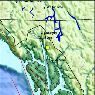
Preferred Hypocentral Solution:
| Local Date: |
Monday May 25th, 2009 |
| Local Time: |
11:55 AM AKDT |
| Universal Time: |
05/25/2009 19:55:39.253 UTC |
| Magnitude: |
3.90 ML |
| Latitude: |
58.8605 |
| Longitude: |
-134.8486 |
| Depth: |
3 miles (5 km) |
| Author: |
oa_op dbg ml |
This earthquake was:
| 34 miles (54 km) SE of Haines |
| 42 miles (67 km) NNW of Juneau |
| 44 miles (71 km) NNW of Douglas |
| 44 miles (71 km) SSE of Skagway |
| 45 miles (72 km) NE of Gustavus |
| 52 miles (84 km) SE of Klukwan |
| 57 miles (91 km) NNE of Hoonah |
| 71 miles (114 km) NE of Elfin Cove |
| 77 miles (123 km) N of Tenakee Springs |
| 80 miles (129 km) NE of Pelican |
| 95 miles (152 km) N of Angoon |
| 117 miles (187 km) S of Whitehorse |
| 117 miles (188 km) SW of Teslin |
| 429 miles (686 km) ESE of Valdez |
| 546 miles (874 km) E of Anchorage |
| 590 miles (944 km) SE of Fairbanks |
| Magnitude |
4.1 (Preliminary magnitude update expected within 15 minutes) |
| Date-Time |
- Monday, May 25, 2009 at 19:55:37 UTC
- Monday, May 25, 2009 at 11:55:37 AM at epicenter
|
| Location |
58.877°N, 134.584°W |
| Depth |
1 km (~0.6 mile) set by location program |
| Region |
SOUTHEASTERN ALASKA |
| Distances |
- 53 km (33 miles) SE (124°) from Mud Bay, AK
- 59 km (36 miles) N (356°) from Juneau, AK
- 63 km (39 miles) SE (128°) from Haines, AK
- 879 km (546 miles) E (100°) from Anchorage, AK
|
| Location Uncertainty |
Error estimate not available |
| Parameters |
NST=008, Nph=008, Dmin=36.7 km, Rmss=0.75
sec, Gp=119°,
M-type=local magnitude (ML), Version=1 |
| Source |
|
| Event ID |
at00328133 |
SEAK71 PAAQ 252000
EQIAKX

TSUNAMI SEISMIC INFORMATION STATEMENT
NWS WEST COAST/ALASKA TSUNAMI WARNING CENTER PALMER AK
1200 PM AKDT MON MAY 25 2009

...THIS IS AN INFORMATION STATEMENT...

EVALUATION
 AN EARTHQUAKE HAS OCCURRED WITH A MAGNITUDE SUCH THAT A TSUNAMI
 WILL NOT BE GENERATED. THIS WILL BE THE ONLY WCATWC MESSAGE
 ISSUED FOR THIS EVENT.

PRELIMINARY EARTHQUAKE PARAMETERS
 MAGNITUDE - 4.1
 TIME      - 1156 AKDT MAY 25 2009
             1256  PDT MAY 25 2009
             1956  UTC MAY 25 2009
 LOCATION  - 58.9 NORTH 134.6 WEST
              35 MILES/56 KM SE OF HAINES ALASKA
              40 MILES/64 KM N OF JUNEAU ALASKA
 DEPTH     - 1 MILES/1 KM

THE LOCATION AND MAGNITUDE ARE BASED ON PRELIMINARY INFORMATION.
FURTHER INFORMATION WILL BE ISSUED BY THE UNITED STATES
GEOLOGICAL SURVEY - EARTHQUAKE.USGS.GOV - OR THE APPROPRIATE
REGIONAL SEISMIC NETWORK.

$$
- 1150: Cloudy with a few breaks and a few
small areas of slightly and partly broken
clouds, fairly bright clouds.
- 1120: Cloudy with some slightly and partly
broken areas and a few other breaks, fairly
bright skies.
- 1050: Mostly/Partly Cloudy with bright clouds,
weak - weakened sunshine.
- 0950: Partly Cloudy with high thinnish, thin,
and very thin clouds and slight high haze
- haze, weakened sunshine.
- 0850: Filtered - Slightly filtered blue sky
with a few high thin and very thin clouds,
slightly weakened sunshine.
- 0820: Partly Cloudy with high thin and very
thin clouds and slightly filtered blue and
slight high haze - haze, sun shining.
- 0805: Partly Cloudy with slightly filtered
blue.
- 0750: Cloudy with breaks and broken and slightly
broken areas, bright clouds to the E, very
weak sunshine in Last Chance Basin.
- 0720: Cloudy with very slightly broken clouds.
- 0650: Overcast with high thinnish, thin,
and very thin clouds, but with thick clouds
over the mainland which are increasing towards
the SW.
- 0620 ADT: Overcast with high thinnish, thin,
and very thin clouds with a few thicker clouds
far to the NE and areas with heavily filtered
blue and hints of blue, weak - very weak
sunshine.
SUNDAY 5/24/09: DATA | New Spruce Tips Emerged Today
- 2106 ADT: Sprinkling, Cloudy.
- 2050: Cloudy.
- 1950: Cloudy.
- 1935: Cloudy.
- 1850: Cloudy, a small bit of heavily filtered
blue to the NE over the inland part of the
mainland.
- 1750: Cloudy, a few hints of blue and a small
area of heavily filtered blue, small bright
area in the clouds in the vicinity of the
sun.
- 1720: Cloudy with a few small areas of filtered
and heavily filtered blue, bright spot where
the sun is.
- 1650: Mostly Cloudy, fairly bright skies.
- 1620: Mostly Cloudy with high thinnish, thin,
and very thin clouds with areas of heavily
filtered and filtered blue and high haze,
bright skies, sun shining.
- 1550: Mostly/Partly Cloudy with bright clouds,
sun shining.
- 1505: Mostly/Partly Cloudy with bright clouds,
sun shining.
- 1450: Mostly Cloudy, fairly bright skies,
bright spot where the sun is.
- 1350: Partly Cloudy with slight high haze
- haze otherwise.
- 1250: Partly Cloudy with mostly cirrus clouds
otherwise slight high haze - haze.
- 1230: Two Great Blue Herons landed in a mountain
hemlock tree to the E and stayed two minutes.
- 1150: Partly Cloudy with high thin and very
thin clouds and slight high haze - haze.
- 1050: Clear with slight high haze - haze
and a bit of high thin and very thin clouds.
- 1005: Clear/Mostly Clear but with slight
high haze - haze.
- 0850: Partly Cloudy/Mostly Clear with high
thin and very thin clouds and slight high
haze - haze.
- 0750: Partly Cloudy with high thin and very
thin clouds and some slight high haze - haze,
slightly weakened sunshine.
- 0650: Partly Cloudy with high thin and very
thin clouds and slight high haze, slightly
to somewhat weakened sunshine.
- 0620 ADT: High thin and very thin clouds,
filtered and heavily filtered blue, slightly
to somewhat weakened sunshine.
- 2050 ADT: Cloudy with thinnish and thicker
clouds, a bit of heavily filtered blue and
hints of blue.
- 1950: Overcast - Cloudy with mostly thinnish
clouds with some areas of filtered and heavily
filtered blue and hints of blue, faint sunbow
near the location of the sun.
- 1920: Overcast with thinnish and thin clouds
with a few areas filtered and heavily filtered
blue and hints of blue.
- 1850: High thinnish, thin, and very thin
clouds with some cumulus clouds over much
of the sky along with filtered and heavily
filtered blue and high haze, weak - very
weak sunshine in most areas.
- 1750: High thin and very thin clouds and
cumulus clouds over much of the sky along
with filtered and heavily filtered blue and
high haze, sun shining in most areas.
- 1650: High thin and very thin clouds and
cumulus clouds over much of the sky along
with filtered and heavily filtered blue and
high haze, weakened - somewhat weakened sunshine
here and there and in and out.
- 1550: High thin and very thin clouds and
cumulus clouds over much of the sky along
with filtered blue and high haze, slightly
to somewhat weakened sunshine.
- 1450: Partly Cloudy but with filtered and
heavily filtered blue and high haze, variable
strength sunshine.
- 1350: Partly Cloudy with slightly filtered
blue and high haze.
- 1320: Partly/Mostly Cloudy, weak - weakened
sunshine.
- 1250: Cloudy with breaks, sun shining.
- 1150: Cloudy, a few very tiny breaks.
- 1050: Cloudy with a few mostly small and
tiny breaks, a few spots and areas of very
weak sunshine on Mt. Roberts.
- 0950: Cloudy, a few very tiny breaks in one
area.
- 0935: Cloudy, one very small break.
- 0850: Cloudy with a few tiny breaks, sun
has been out in the past hour.
- 0750: Cloudy, a few very tiny breaks.
- 0650: Cloudy with some small and tiny breaks
and hints of breaks.
- 0620 ADT: Cloudy with some very tiny breaks
and hints of breaks.
- 2050 ADT: Partly Cloudy with high thinnish,
thin and very thin clouds, and slight high
haze - haze elsewhere, weakened sunshine
on the mainland.
- 1950: High thin and very thin clouds over
much of the sky and high haze, slight high
haze, and filtered blue elsewhere, slightly
weakened sunshine.
- 1850: Partly Cloudy with mostly high thin
and very thin clouds and slight high haze
- haze.
- 1750: Partly Cloudy.
- 1650: Partly Cloudy with slight high haze
- haze, sun shining in most areas.
- 1550: Partly Cloudy with slight high haze
- haze, weak to weakened sunshine.
- 1450: Mostly Cloudy, extremely weak sunshine.
- 1420: Partly Cloudy, weak sunshine.
- 1405: Mostly Clear with fairly large area
of broken clouds overhead, variable strength
sun in and out.
- 1350: Mostly Clear.
- 1250: Clear with slight high haze - haze.
- 1150: Clear with slight high haze - haze
and some high very thin clouds.
- 1050: Clear with slight high haze - haze,
some high very thin clouds in the SE part
of the sky.
- 0950: Clear with slight high haze - haze,
a bit of high very thin clouds far to the
SE and a few tiny clouds far to the NW.
- 0850: Clear.
- 0750: Clear.
- 0650: Clear.
- 0620 ADT: Clear.
- 2050 ADT: Clear.
- 1950: Clear with a couple of small clouds
and a very small cloud.
- 1850: Clear with a few clouds.
- 1835: Clear/Mostly Clear.
- 1750: Clear with a few small clouds SE half
of sky, Partly Cloudy NW half, sun shining
on the mainland.
- 1735: Clear with a few clouds SE half of
sky, Partly Cloudy NW half, sun shining on
most of the mainland.
- 1650: Partly Cloudy, sun shining in most
areas.
- 1605: Partly Cloudy, sun shining here and
there and in and out.
- 1550: Mostly/Partly Cloudy, sun shining here
and there and in and out.
- 1520: Partly Cloudy, spots and areas of sunshine
on the mainland.
- 1450: Mostly Cloudy, spots and areas of weak
sunshine on the mainland.
- 1350: Partly Cloudy, variable strength sun
in and out and here and there.
- 1250: Partly Cloudy, variable strength sun
in and out and here and there.
- 1150: Partly Cloudy, sun in and out and here
and there.
- 1050: Partly Cloudy.
- 1020: Partly/Mostly Cloudy, spots and areas
of weakened sunshine on the mainland.
- 0950: Partly Cloudy.
- 0920: Mostly Cloudy, variable sunshine.
- 0850: Mostly Cloudy. extremely weak to weak
sunshine.
- 0820: Partly Cloudy, light wind.
- 0750: Partly Cloudy, cloud over the top Channel
slope of Mt. Juneau, sun shining.
- 0735: Partly Cloudy, slightly to somewhat
weakened sunshine.
- 0650: Cloudy with some broken clouds and
some clear sky to the S and SW.
- 0620 ADT: Cloudy with a few breaks.
- 2050 ADT: Partly Cloudy.
- 2020: Cloudy with a clear area and some breaks,
light precipitation in the Granite Creek
area.
- 1950: Cloudy with a small clear area and
a few breaks.
- 1850: Cloudy with a clear area and some breaks,
sun shining on parts of the mainland.
- 1820: Mostly Cloudy, sun in and out and here
and there.
- 1750: Partly Cloudy, sun shining here and
there and in and out.
- 1705: Partly Cloudy, sun shining here and
there and in and out.
- 1650: Mostly/Partly Cloudy, sun in and out
and shining here and there.
- 1635: Mostly Cloudy, sun shining on parts
of the mainland.
- 1550: Cloudy/Mostly Cloudy, sun shining on
parts of the mainland.
- 1535: Mostly/Partly Cloudy, sun in and out
and shining here and there.
- 1520: Mostly/Partly Cloudy, spots and areas
of sunshine on the mainland.
- 1450: Partly Cloudy with cumulus, slight
high haze - haze, and a bit of high thin
and very thin clouds, sun shining here and
there on the mainland.
- 1435: Partly Cloudy with cumulus and high
thin and very thin clouds (more clouds than
at 1350), and slight high haze - haze, sun
in and out.
- 1350: Partly Cloudy with cumulus and high
thin and very thin clouds and some slight
high haze - haze.
- 1250: Partly Cloudy with high thin and very
thin clouds with filtered and heavily filtered
blue elsewhere, slightly weakened sunshine.
- 1150: High thin and very thin clouds and
filtered and heavily filtered blue, somewhat
weakened - weakened sunshine, a few tiny
whitecaps on the Channel.
- 1050: High thinnish, thin, and very thin
overcast with hints of blue and heavily filtered
blue, weakened - weak sunshine, some tiny
whitecaps on the Channel.
- 1020: High thinnish, thin, and very thin
overcast with hints of blue and heavily filtered
blue, weakened - weak sunshine, a few tiny
whitecaps on the Channel.
- 0950: Overcast with thinner areas with hints
of blue, fairly bright skies, very weak -
weak sunshine, halo around the sun, a few
tiny whitecaps on Gastineau Channel.
- 0850: Cloudy, extremely weak sunshine.
- 0750: Cloudy, extremely weak - very, very
weak sunshine.
- 0735: Cloudy, extremely weak sunshine.
- 0650: Cloudy, location of sun visible (very
weak bright spot).
- 0630: A New Weekly Picture has been posted - Skunk Cabbage.
- 0620 ADT: Cloudy.
- 2050 ADT: High thinnish, thin, and very thin
clouds over the sky with some filtered and
heavily filtered blue, extremely weak sunshine
on the mainland.
- 2020: High thinnish, thin, and very thin
clouds over the sky with some filtered and
heavily filtered blue, extremely weak sunshine
on the mainland.
- 1950: High thinnish, thin, and very thin
clouds over the sky with some filtered and
heavily filtered blue, weakened - weak sunshine.
- 1850: High thinnish, thin, and very thin
clouds over most of the sky along with filtered
and heavily filtered blue, somewhat weakened
sunshine.
- 1750: Thin and very thin clouds over most
of the sky along with filtered and heavily
filtered blue, slightly weakened sunshine.
- 1650: Partly Cloudy with high thin and very
thin clouds and slight high haze- haze, some
high thinnish clouds far to the NW.
- 1635: Three Mountain Goats spotted high on
Mt. Juneau.
- 1550: Clear with a few high thin and very
thin clouds and slight high haze - haze.
- 1450: Mostly Clear/Partly Cloudy with high
thin and very thin clouds and slight high
haze - haze.
- 1350: Clear/Mostly Clear with high thin and
very thin clouds and slight high haze - haze.
- 1250: Clear with slight high haze - haze,
and a small bit of high very thin clouds
far to the NW.
- 1150: Clear with some high thin and very
thin clouds and slight high haze - haze,
light wind.
- 1050: Clear with slight high haze - haze,
high thinnish and thin clouds far to the
NW.
- 0950: Clear with some slight high haze, some
high thinnish and thin clouds far to the
NW.
- 0850: Clear with some slight high haze, some
high thin clouds far to the NW.
- 0750: Clear with some slight high haze -
haze, some high thin clouds far to the NW.
- 0650: Clear.
- 0620: Clear. There is a thin layer of Ice
on the Bird Bath.
- 0532 (about) ADT: The Sun started rising
over the mainland mountains to the NE.
- 2050 ADT: Clear but with clouds far to the
NW and otherwise slight high haze - haze,
light wind in the past 10 minutes.
- 1950: Clear/Mostly Clear with thinnish clouds
far to the NW otherwise slight high haze
- haze, light wind.
- 1850: Mostly Clear with some high thinnish,
thin, and very thin clouds in the NW 1/4
of the sky and some slight high haze and
haze elsewhere.
- 1750: Clear with some high very thin clouds
in the NW 1/4 of the sky and thinnish and
thin clouds far to the NW, some slight high
haze - haze elsewhere.
- 1650: Clear with some high very thin clouds
in the NW 1/4 of the sky, and a bit of high
thin haze - haze elsewhere.
- 1550: Clear with some slight high haze -
haze, light wind.
- 1450: Clear with some slight high haze -
haze, light to breezy wind.
- 1350: Clear with some slight high haze, light
wind with occasional gusts.
- 1250: Clear, a bit of slight high haze, occasional
gusts.
- 1150: Clear.
- 1050: Clear.
- 0950: Clear.
- 0850: Clear, light wind in the past 15 minutes.
- 0750: Clear.
- 0735: Clear, breezy.
- 0650: Clear, light to breezy wind.
- 0635: Clear, light wind.
- 0620: Clear.
- 0605: Clear.
- 0542 (about) ADT: The Sun started rising
over the far left shoulder of Mt. Roberts.
SUNDAY 5/17/09: DATA | NWS: A Wind Advisory was in effect until
10 AM Today - See 2331 5/16
- 2100 ADT: Trace of Rainfall to this point
today.
- 2050: Cloudy, precipitation to the E over
Mt. Roberts, light to breezy wind.
- 1950: Cloudy, precipitation in part of the
inner Gold Creek valley.
- 1850: Cloudy, light wind.
- 1820: Cloudy, light wind, some precipitation
in the inner Gold Creek valley in the past
15 minutes.
- 1800: Trace of Rainfall to this point today.
- 1750: Cloudy, light to breezy wind.
- 1720: Cloudy, a bit of precipitation in the
inner Gold Creek valley and over part of
the top of the Mt. Juneau Ridge, light wind,
a few very tiny whitecaps on part of the
Channel.
- 1650: Cloudy, bright area where the sun is,
precipitation in the inner Gold Creek valley
and around part of the top of Mt. Roberts,
light wind, tiny whitecaps on part of the
Channel.
- 1550: Cloudy, disc of the sun visible, precipitation
in the inner Gold Creek valley, breezy.
- 1520: Cloudy, bright spot where the sun is,
precipitation in the Granite Creek area and
the very top of the Mt. Juneau Ridge, breezy,
occasional strong gusts in the past 20 minutes.
- 1500: Trace of Rainfall to this point today.
- 1450: Cloudy, breezy, bright spot where the
sun is.
- 1435: A few light sprinkles, cloudy, bright
spot where the sun is, breezy.
- 1433: A Bald Eagle is soaring in the wind
high overhead.
- 1350: Cloudy, precipitation in the inner
Gold Creek valley, disc of the sun visible,
light wind with occasional gusts.
- 1250: Cloudy, bright spot where the sun is,
precipitation in the inner Gold Creek valley,
light to breezy to breezy wind with occasional
gusts.
- 1220: Cloudy, precipitation in the inner
Gold Creek valley, over Mt. Roberts, and
part of Mt. Juneau, light wind with occasional
gusts.
- 1200: Trace of Rainfall to this point today.
- 1150: Cloudy, bright spot where the sun is,
precipitation in the inner Gold Creek valley
and over part of the top of Mt. Juneau, light
wind.
- 1050: Cloudy, precipitation in the Granite
Creek area and the top of the Mt. Juneau
Ridge.
- 1020: Very Light Sprinkling, Cloudy, heavier
precipitation in the inner Gold Creek valley
and over the top of Mt. Roberts, light wind
with occasional gusts, whitecaps on the Channel
- mostly small and tiny.
- 0950: Cloudy, precipitation in the Granite
Creek area, over much of the top of the Mt.
Juneau Ridge, and over part of the top of
Mt. Roberts, light wind, whitecaps on part
of the Channel.
- 0850: Cloudy, disc of the sun visible, light
to breezy wind with occasional gusts, whitecaps
on part of the Channel.
- 0835: Cloudy, bright area where the sun is,
light wind, windier closer to and over the
Channel.
- 0750: Cloudy, precipitation in the Granite
Creek area and the top of the Mt. Juneau
Ridge, light to breezy to breezy wind, some
mostly small whitecaps on the Channel.
- 0700: Trace of Rainfall to this point today.
- 0650: Very Light Sprinkles Cloudy, light
wind with occasional gusts, some mostly small
whitecaps on Gastineau Channel.
- 0643: Very Light Sprinkles Cloudy, light
wind.
- 0620 ADT: Cloudy, precipitation in the Granite
Creek area and the very top of the Mt. Juneau
Ridge, light wind with occasional gusts.
Trace of Rainfall to this point today from
sprinkles.
Sat. 5/16/09: DATA | 0633: Dusting of Snow visible on the very
tops - tops of the mainland mountains
- 2331 ADT (Posted here at 0630 5/17):
NWS Wind Advisory
Statement as of 11:31 PM AKDT on May 16, 2009

...Wind Advisory in effect until 10 am akdt Sunday...

The National Weather Service in Juneau has issued a Wind
Advisory...which is in effect until 10 am akdt Sunday.

Strong winds with gusts to 50 mph will continue near downtown
Juneau and Douglas through the rest of tonight into Sunday morning.

Precautionary/preparedness actions...

A Wind Advisory means that sustained wind speed or frequent gusts
will occur between 40 and 60 mph.

This statement will be updated by 500 am akdt Sunday or sooner if
conditions warrant.
- 2050 ADT: Cloudy-Overcast, light to breezy
wind, sun shining on part of downtown and
on Mt. Roberts. .05" of Rainfall to
this point today.
- 2020: Cloudy (basically the same as at 1950).
- 2005: Cloudy (basically the same as at 1950),
light wind with gusts from the SW to W (unusual).
- 1950: High Overcast with mid-level clouds
over about half the sky.
- 1850: Cloudy, areas of thinner clouds.
- 1800: .05" of Rainfall to this point
today.
- 1750: Cloudy.
- 1705: Cloudy with a few hints of blue, somewhat
bright skies.
- 1650: Overcast with a few small and tiny
breaks and hints of blue, fairly bright skies,
extremely weak sunshine.
- 1550: High thinnish, thin, and very thin
clouds with heavily filtered and filtered
blue, weakened sunshine, partial halo around
the sun.
- 1520: High thinnish and thin clouds over
most of the sky with hints of blue and heavily
filtered blue, weakened - weak sunshine.
- 1500: .05" of Rainfall to this point
today.
- 1450: Cloudy/Mostly Cloudy with thinnish
clouds, very weak sunshine.
- 1420: Mostly Cloudy with thinnish clouds,
very weak sunshine.
- 1350: Mostly Cloudy with thinnish clouds,
weak - weakened sunshine.
- 1335: Partly/Mostly Cloudy with thinnish
clouds and a few small cumulus, weak sunshine.
- 1250: Partly Cloudy.
- 1200: .05" of Rainfall to this point
today.
- 1150: Partly Cloudy.
- 1050: Partly Cloudy, a few wisps by the top
of Mt. Juneau and a cloud by the SE part
of the top of Mt. Roberts, slightly weakened
sunshine.
- 0950: Partly Cloudy, a few clouds and wisps
around the top of Mt. Juneau and of Mt. Roberts,
slightly weakened sunshine.
- 0850: Partly Cloudy, some clouds on the Channel
- Last Chance Basin side of Mt. Juneau, some
wisps and bits over the Douglas Island bench,
slightly weakened sunshine.
- 0750: Cloudy with areas of heavily filtered
blue, somewhat weakened sunshine, lower band/ribbon
of fog/clouds.
- 0720: Cloudy, weak - weakened sunshine, lower
ribbon and wisps.
- 0700: .05" of Rainfall to this point
today.
- 0650: Cloudy, lower ribbon and wisps, a few
hints of breaks and of blue.
- 0635: Cloudy, lower ribbon and wisps, a few
hints of breaks.
- 0620: Cloudy, very slight hints of blue,
very weak sunshine, lower band/ribbon of
fog/clouds. .05" of Rainfall to this
point today.
- 0100 ADT: High Rain Rate of .02" of
Rain per hour.
- 2100 ADT: .07" of Rainfall to this point
today.
- 2050: Light Misting/Sprinkling, Cloudy, very
top - top of Mt. Juneau and of the Mt. Juneau
Ridge, and very top of Mt. Roberts in clouds.
- 2020: Light Rain, Cloudy, very tops - tops
of the mainland mountains in clouds.
- 1950: Very Light Rain, Cloudy, clouds skimming
- very top of Mt. Juneau in clouds, clouds
skimming the Mt. Juneau Ridge, most of the
very top of Mt. Roberts in clouds.
- 1920: Sprinkling, Cloudy, part of the top
of the Mt. Juneau Ridge and very top - top
of Mt. Roberts partially obscured.
- 1905: Very Light Sprinkling, Cloudy.
- 1850: Cloudy, very light precipitation over
parts of the mainland.
- 1820: Cloudy.
- 1800: .03" of Rainfall to this point
today.
- 1750: Cloudy, precipitation over parts of
the mainland.
- 1720: Cloudy.
- 1620: Cloudy, precipitation over the mainland.
- 1554: Short-lived very faint, shallow arced
Rainbow to the NE.
- 1550: Very Light Rain, Cloudy.
- 1520: Cloudy with some very small and tiny
breaks, sun shining (in and out).
- 1520: Cloudy.
- 1500: .03" of Rainfall to this point
today.
- 1450: Cloudy, clouds skimming Mt. Juneau
and the Mt. Juneau Ridge, precipitation over
the mainland.
- 1435: Very Light Rain, Cloudy, clouds skimming
Mt. Juneau and the Mt. Juneau Ridge, very
top of Mt. Roberts in clouds.
- 1405: Cloudy, a few hints of breaks, inner
Gold Creek valley mostly filled with clouds,
much of the very top of Mt. Roberts in clouds,
areas of very weak sunshine on the mainland.
- 1350: Rain, Cloudy, mainland mountaintops
in clouds.
- 1335: Sprinkling, Cloudy, very top of Mt.
Roberts and of the Mt. Juneau Ridge, and
SE part of the top of Mt. Juneau in clouds.
- 1320: Rain, Cloudy, mainland mountaintops
in clouds, mainland slightly to partially
obscured.
- 1317: High Rain Rate of .09" of Rain
per hour.
- 1305: Very Light Rain, Cloudy, top of Mt.
Roberts and of Mt. Juneau in clouds, clouds
skimming the Mt. Juneau Ridge, parts of the
mainland slightly and partially obscured.
- 1250: Cloudy, top of Mt. Juneau mostly in
clouds, top of Mt. Roberts in clouds.
- 1235: A few Sprinkles, Cloudy, very top -
top of Mt. Juneau, of Mt. Roberts, and of
the Mt. Juneau Ridge in clouds.
- 1220: Light Drizzle, Cloudy, very top - top
of Mt. Juneau and of Mt. Roberts, and the
upper part of the Mt. Juneau Ridge hidden
by clouds, remainder of the inner Gold Creek
valley, Last Chance Basin, and of Mt. Roberts
partially obscured.
- 1205: Very Light Sprinkling, Cloudy, very
top of Mt. Roberts and of Mt. Juneau in clouds,
clouds skimming the Mt. Juneau Ridge.
- 1150: Cloudy, clouds skimming Mt. Juneau,
most of the very top of Mt. Roberts in clouds.
- 1050: Cloudy.
- 1035: Cloudy, a few spots of very weak sunshine
on Mt. Roberts.
- 0950: Cloudy.
- 0850: Cloudy.
- 0820: Cloudy.
- 0750: Cloudy, a few wisps around the very
top of the Mt. Juneau Ridge.
- 0650: Cloudy, a few very, very tiny breaks.
- 0620: Cloudy with very tiny breaks and hints
of breaks.
- 0550 ADT: Cloudy with hints of breaks.
Thur. 5/14/09: DATA
- 2050 ADT: Cloudy with a few small clear areas
and small and tiny breaks, clouds skimming
the top of Mt. Juneau and of the Mt. Juneau
Ridge. Trace of Rainfall to this point today.
- 1950: Cloudy with a filtered clear area and
some breaks, clouds skimming Mt. Juneau and
part of the Mt. Juneau Ridge.
- 1948: A Great Blue Heron is flying N.
- 1850: Cloudy with a clear area and a few
breaks, wisps around the peak of Mt. Juneau
and one of the high points of the Mt. Juneau
Ridge, light wind.
- 1820: Cloudy with a few small clear spots-areas
and a few tiny breaks, clouds skimming part
of the Mt. Juneau Ridge.
- 1800: Trace of Rainfall to this point today.
- 1750: Cloudy, a few small and tiny breaks,
wisps around one of the high points of the
Mt. Juneau Ridge, sun shining in West Juneau.
- 1650: Cloudy with some breaks, clouds skimming
the mainland mountaintops, variable strength
sunshine here and there.
- 1635: Cloudy with breaks, sun shining here
and there.
- 1630: Very Light Rain, Mostly Cloudy, sun
shining here and there, clouds skimming Mt.
Juneau.
- 1620: Cloudy with some breaks, clouds skimming
peak of Mt. Juneau and one of the high points
on the Mt. Juneau Ridge.
- 1550: Cloudy with breaks, a few spots and
areas of weakened, weak, and very weak sunshine
on the mainland.
- 1535: Mostly Cloudy, clouds skimming the
Mt. Juneau Ridge, precipitation in the Granite
Creek area, spots of weakened, weak, and
very weak sunshine on the mainland.
- 1500: Trace of Rainfall to this point today.
- 1450: Cloudy with some breaks, variable strength
sunshine in and out and here and there.
- 1420: Cloudy with a few breaks, spots of
weak and very weak sunshine on parts of the
mainland, clouds skimming the high points
of the Mt. Juneau Ridge.
- 1405: Cloudy with some very tiny breaks,
clouds skimming Mt. Juneau, the Mt. Juneau
Ridge, and small part of Mt. Roberts, sun
shining in West Juneau.
- 1350: Very Light Sprinkling, Cloudy, very
small filtered break to the SSE, a few other
hints of breaks, clouds skimming the Mt.
Juneau Ridge and Mt. Roberts.
- 1347: Very Weak Sunshine briefly.
- 1320: Cloudy, clouds skimming Mt. Juneau
and the Mt. Juneau Ridge; precipitation in
the inner Gold Creek valley, part of Last
Chance Basin, and small part of the top of
Mt. Roberts.
- 1250: Cloudy, clouds skimming Mt. Juneau
Ridge, a few wisps around the peak of Mt.
Juneau, a few small bright spots in the clouds.
- 1220: Cloudy, a few very small and tiny filtered
breaks and bright spots, clouds skimming
Mt. Juneau, very top of the Mt. Juneau Ridge
in clouds.
- 1200: Trace of Rainfall to this point today.
- 1150: Sprinkling, Cloudy, clouds skimming
Mt. Juneau, very top of the Mt. Juneau Ridge
in clouds.
- 1135: Light Sprinkling, Cloudy, clouds skimming
Mt. Juneau and the Mt. Juneau Ridge, brighter
area in the clouds to the S.
- 1050: Sprinkling/Very Light Rain, Cloudy,
bright spot where the sun is, very top of
Mt. Juneau and of the Mt. Juneau Ridge, and
most of the very top of Mt. Roberts in clouds.
- 1034: Very Light Sprinkling, Cloudy, very
top of Mt. Juneau and of the Mt. Juneau Ridge,
and most of the very top of Mt. Roberts in
clouds.
- 0950: Cloudy, clouds skimming Mt. Juneau
and the Mt. Juneau Ridge; light precipitation
over parts of the mainland.
- 0850: Cloudy, lower clouds skimming Mt. Juneau
and the Mt. Juneau Ridge and part of Mt.
Roberts.
- 0750: Cloudy, a few wisps around the peak
of Mt. Juneau and the high points of the
Mt. Juneau Ridge.
- 0650: Cloudy, very top of the Mt. Juneau
Ridge in clouds.
- 0620: Cloudy, a few clouds and wisps around
the very top of the Mt. Juneau Ridge.
- 0550 ADT: Cloudy with clouds skimming Mt.
Juneau and the Mt. Juneau Ridge, light precipitation
in the inner Gold Creek valley, a few hints
of breaks and a few tiny breaks, bright spots
to the NE. A Bald Eagle is in a tree to the
E along the shore.
Wed. 5/13/09: DATA | A Frost Advisory was in effect until 7
AM this morning - See 0324 Below | Buds are starting to show on the Spruce
Trees | West Juneau Weekly Picture - Panorama of the Gold Creek Watershed
- 2050 ADT: Mostly Cloudy with high thinnish,
thin, and very thin clouds and a few mid-level
clouds and filtered and heavily filtered
blue, very weak sunshine on parts of downtown
and the mainland waterfront.
- 1950: Thinnish, thin, and very thin clouds
with some thicker clouds over the sky and
some filtered and heavily filtered blue,
and hints of blue.
- 1935: High thinnish, thin, and very thin
clouds over the sky with some filtered and
heavily filtered blue, and hints of blue.
- 1850: Overcast with thinnish clouds with
streaks of filtered and heavily filtered
blue and areas with hints of blue, very weak
sunshine.
- 1750: Overcast with thinnish clouds, a few
hints of blue, halo around the sun, extremely
weak - very, very weak sunshine.
- 1650: Overcast with mostly thinnish clouds,
a few thinner spots and areas with hints
of blue, some mid-level clouds, weak sunshine.
- 1635: Overcast with mostly thinnish clouds,
a few thinner spots and hints of blue, some
mid-level clouds, weak sunshine.
- 1550: Overcast with mostly thinnish clouds,
a few thinner spots and hints of blue, some
mid-level clouds, extremely weak sunshine
on parts of the mainland.
- 1520: Overcast with mostly thinnish clouds,
a few thinner spots and hints of blue, some
lower cumulus, extremely weak sunshine on
parts of the mainland.
- 1450: Mostly Cloudy with high thinnish, thin,
and very thin clouds, cumulus clouds, and
heavily filtered - filtered blue, weakened
- weak sun in and out and here and there.
- 1435: Mostly Cloudy with high thinnish, thin,
and very thin clouds, cumulus clouds, and
heavily filtered - filtered blue, weakened
- weak sun in and out and here and there.
- 1350: Partly Cloudy with high thin and very
thin clouds and scattered cumulus clouds,
sun in and out and here and there.
- 1250: Mostly Clear with scattered cumulus,
sun in and out.
- 1150: Mostly Clear/Clear with some puffy
clouds.
- 1050: Clear, a few small and tiny clouds,
some very small whitecaps on part of Gastineau
Channel.
- 0950: Clear with a small high very thin cloud
(cirrus), and slight high haze.
- 0850: Clear with slight high haze.
- 0750: Clear with a small high thin cloud
and some slight high haze.
- 0650: Clear, a few thin clouds far to the
NW
- 0620: Clear.
- 0556: The Sun is starting to rise over the
left shoulder of Mt. Roberts, to the left
of Snowslide Gulch in Last Chance Basin.
- 0550: Clear with slight high haze.
- 0505: Clear with slight high haze - haze.
Thin layer of Ice on the Bird Bath.
- 0324 ADT (Posted here at 0505):
NWS Frost Advisory
Statement as of 3:24 AM AKDT on May 13, 2009

...Frost advisory remains in effect until 7 am akdt this
morning...

A frost advisory remains in effect until 7 am akdt this morning.

Frost will continue in wind sheltered locations inland from
channels and canals. Temperatures are 28 to 32 degrees.

Precautionary/preparedness actions...

Frost advisories are issued during the growing season so that
sensitive plants can be covered or brought inside before damage
occurs.

Plants subject to damage from frost should be given the
appropriate protection.

This statement will be updated by 7 am akdt Wed or sooner if
conditions warrant.


Nb
Tue. 5/12/09: DATA | A Frost Advisory is in effect from Midnight
Tonight to 7 AM Wednesday | National Peace
Officers' Memorial Observance - Noon at the
Alaska State Museum lawn | A Frost Advisory
was in effect from Midnight to 0700 Today
- See 0524 Below and 2032 5/11
- 2050 ADT: Clear.
- 1950: Clear with slight high haze, a few
clouds far to the NW.
- 1850: Mostly Clear with slight high haze
- haze.
- 1750: Mostly Clear/Clear along with slight
high haze - haze.
- 1735: Clear/Mostly Clear along with slight
high haze - haze.
- 1650: Mostly Clear/Partly Cloudy with high
thin and very thin clouds, a few small cumulus,
and slight high haze - haze.
- 1550: Partly Cloudy with high thinnish, thin,
and very thin clouds and slight high haze
- haze, very slightly weakened sunshine.
- 1535: Partly Cloudy with high thinnish, thin,
and very thin clouds and slight high haze
- haze, very slightly weakened sunshine.
- 1450: Mostly Overcast with high thinnish,
thin, and very thin clouds with heavily filtered,
filtered blue, hints of blue, weakened -
somewhat weakened sunshine.
- 1420: Mostly Overcast with high thinnish,
thin, and very thin clouds with heavily filtered,
filtered blue, hints of blue, weakened -
somewhat weakened sunshine.
- 1350: Overcast with thinnish clouds and hints
of blue and a bit of heavily filtered and
filtered blue, fairly bright skies, extremely
weak sunshine.
- 1335: Overcast with thinnish clouds and hints
of blue and a bit of heavily filtered and
filtered blue, bright skies, weak - very
weak sunshine.
- 1250: Thinnish, thin, and very thin clouds
over most of the sky with some other clouds,
and filtered and heavily filtered blue, somewhat
weakened sunshine.
- 1150: High thinnish, thin, and very thin
clouds over much of the sky with some other
clouds, and filtered and heavily filtered
blue and high haze with weakened sunshine.
- 1050: Mostly Overcast with high thinnish,
thin, and very thin clouds and filtered and
heavily filtered blue, weak sunshine.
- 0950: Overcast with high thinnish, thin,
and very thin clouds and heavily filtered
and filtered blue, weakened - weak sunshine.
- 0850: Mostly Overcast with high thinnish,
thin, and very thin clouds and filtered and
heavily filtered blue, weakened sunshine.
- 0750: Overcast with high thinnish and thin
clouds and a thinner area with a hint of
blue, very weak sunshine.
- 0720: Overcast with high thinnish, thin,
and very thin clouds with some areas of thicker
clouds and a few areas of heavily filtered
- filtered blue, very weak sunshine.
- 0650: Mostly Overcast with high thinnish,
thin, and very thin clouds, some thicker
clouds at a lower altitude to the ENE hiding
the sun, filtered blue.
- 0635: Mostly Overcast with high thinnish,
thin, and very thin clouds and some thicker
clouds at a lower altitude to the NE, filtered
blue, very weak sunshine.
- 0620: Mostly Overcast with high thinnish,
thin, and very thin clouds, filtered blue,
weak - weakened sunshine. Very thin layer
of Ice on the Bird Bath.
- 0524 ADT (Posted here at 0630):
NWS Frost Advisory
Statement as of 5:24 AM AKDT on May 12, 2009

...Frost advisory remains in effect until 7 am akdt this
morning...

A frost advisory remains in effect until 7 am akdt this morning.

Mostly clear skies and light winds have allowed temperatures to
fall to near freezing this morning in sheltered and low-lying
areas and areas of frost have developed as a result. Frost will
continue until temperatures quickly warm over the next few hours.

Precautionary/preparedness actions...

An advisory means that frost is already occurring or imminent.

Frost advisories are issued during the growing season so that
sensitive plants can be covered or brought inside before damage
occurs.

Plants subject to damage from frost should be given the
appropriate protection.

This statement will be updated by 7 am akdt Tue or sooner if
conditions warrant.
Mon. 5/11/09: DATA | A Frost Advisory issued by the NWS at
10:01 PM 5/10 was in Effect until 6 AM Today
- See 2201 5/10 - There was some frost on the Back Loop
Road - See 0549 Below
- 2050 ADT: Clear with slight high haze; some
thin clouds far to the NW, light wind.
- 2032 (Posted here at 0626 5/12 - I'm sorry I missed it
5/11 evening):
NWS Frost Advisory
Statement as of 8:30 PM AKDT on May 11, 2009

...Frost advisory in effect from midnight tonight to 7 am akdt
Tuesday...

The National Weather Service in Juneau has issued a frost
advisory...which is in effect from midnight tonight to 7 am akdt
Tuesday.

Mostly clear skies and light winds will allow temperatures to
fall near freezing in sheltered valleys. Areas of frost are
likely to develop in these areas.

Precautionary/preparedness actions...

An advisory means that frost is already occurring or imminent.

Frost advisories are issued during the growing season so that
sensitive plants can be covered or brought inside before damage
occurs.

Plants subject to damage from frost should be given the
appropriate protection.

This statement will be updated by 5 am akdt Tue or sooner if
conditions warrant.
- 1950: Clear with slight high haze.
- 1850: Clear with slight high haze.
- 1750: Clear with slight high haze - haze;
a few high thin and very thin clouds to the
SE, light wind.
- 1650: Clear with a few high thin and very
thin clouds, slight high haze - haze.
- 1550: Clear with a few high thin and very
thin clouds, slight high haze - haze.
- 1535: Clear with a few high thin and very
thin clouds, slight high haze - haze.
- 1450: Mostly Clear with high thin and very
thin clouds and slight high haze - haze,
light wind.
- 1420: Partly Cloudy with high thin and very
thin clouds and slight high haze - haze.
- 1350: High Thinnish, thin, and very thin
clouds and slight high haze - haze, slightly
weakened sunshine.
- 1250: High Thinnish, thin, and very thin
clouds over most of the sky with slight high
haze - haze and hints of blue and heavily
filtered blue, weakened sunshine.
- 1150: Overcast with high thinnish, thin,
and very thin clouds with hints of blue and
heavily filtered blue, light to light - breezy
wind, a few tiny whitecaps on the Channel,
weak - weakened sunshine.
- 1105: High Thinnish, thin, and very thin
clouds with hints of blue and heavily filtered
blue, breezy, somewhat weakened sunshine,
some whitecaps on Gastineau Channel - most
of them tiny.
- 1050: High Thinnish, thin, and very thin
clouds over much of the sky, high haze, light
to light - breezy wind, slightly weakened
sunshine.
- 0950: Partly Cloudy with high thin and very
thin clouds and slight high haze - haze,
light wind.
- 0850: Partly Cloudy with high thin and very
thin clouds and slight high haze - haze,
most of the clouds in the NW part of the
sky.
- 0835: Partly Cloudy with high thin and very
thin clouds and slight high haze - haze,
most of the clouds in the NW part of the
sky, light to breezy wind.
- 0750: Mostly Clear, light wind.
- 0650: Mostly Clear.
- 0620: Mostly Clear.
- 0602: The Sun is starting to rise over the
left shoulder of Mt. Roberts.
- 0549 ADT (Posted here at 0630):
Frost Advisory
Statement as of 5:49 AM AKDT on May 11, 2009

...Frost advisory will expire at 6 am akdt early this morning...

The frost advisory will expire at 6 am akdt early this morning.

A few low lying and sheltered areas have frosted overnight...
especially in the Mendenhall Valley. Temperatures are quickly
warming above freezing early this morning and further frost
formation is not expected.

This will be the final statement on this event.
SUNDAY 5/10/09: DATA | Mother's Day
- 2201 ADT (Posted here at 0620 5/11):
NWS Frost Advisory
Statement as of 10:01 PM AKDT on May 10, 2009

...Frost advisory in effect until 6 am akdt Monday for downtown Juneau and the Mendenhall Valley...

The National Weather Service in Juneau has issued a frost
advisory...which is in effect until 6 am akdt Monday.

Mostly clear skies and light winds will allow temperatures to
fall to near freezing in the north Douglas...Juneau and Mendenhall
Valley tonight.

Precautionary/preparedness actions...

An advisory means that frost is already occurring or imminent.

Frost advisories are issued during the growing season so that
sensitive plants can be covered or brought inside before damage
occurs.

Plants subject to damage from frost should be given the
appropriate protection.

Sensitive plants and shrubs should be covered or brought indoors
if possible.

This statement will be updated by 6 am akdt Monday or sooner
if conditions warrant.
- 2050: High Thinnish, thin, and very thin
clouds with high haze and filtered and heavily
filtered blue, weak - weakened sunshine on
the mainland, light wind.
- 1950: Overcast with thinnish and thin clouds
with some areas of heavily filtered blue
and hints of blue, weakened sunshine.
- 1850: Overcast with thinnish and thin clouds
and some very thin clouds with heavily filtered
blue and hints of blue, weakened sunshine.
- 1750: High Thinnish, thin, and very thin
clouds with high haze and slightly filtered
blue, slightly weakened sunshine.
- 1650: High Thinnish, thin, and very thin
clouds with high haze and filtered and slightly
filtered blue, slightly weakened sunshine.
- 1550: High Thinnish, thin, and very thin
overcast over much of the sky but with thicker
clouds SW part of the sky and areas of filtered
blue, weakened, extremely weak and weak sunshine.
- 1450: High thinnish, thin and very thin clouds
with high haze and filtered blue, somewhat
weakened sunshine.
- 1350: High thin and very thin clouds and
thinnish clouds with high haze - thin haze
and filtered and slightly filtered blue,
slightly weakened sunshine.
- 1250: High thin and very thin clouds and
thinnish clouds with high haze - thin haze
and filtered and slightly filtered blue,
slightly weakened sunshine.
- 1150: High thinnish, thin and very thin clouds
and a bit of heavily filtered blue and hints
of blue SE 4/5ths of the sky, Partly Cloudy
NW 1/5th with high haze, weakened sunshine.
- 1050: High thinnish, thin, and very thin
clouds, high haze - thin haze and filtered
and slightly filtered blue, somewhat weakened
sunshine.
- 0950: Partly Cloudy with high thin and very
thin clouds, high thinnish clouds, and slight
high haze - haze.
- 0850: Partly Cloudy with high thin and very
thin clouds and slight high haze - haze.
- 0750: High thin and very thin clouds, high
haze - slight haze, and some thinnish clouds
over the sky.
- 0650: High thin and very thin clouds and
high haze over the sky.
- 0635: High thin and very thin clouds and
high haze over the sky.
- 0620: High thinnish, thin, and very thin
clouds and high haze over the sky. There
is a very thin layer of Ice on the Bird Bath.
- 0607: The Sun is starting to rise over the
left shoulder of Mt. Roberts.
- 0329 ADT: A Robin is singing.
- 2050 ADT: Cloudy with areas of very slightly
broken clouds. .02" of Rainfall to this
point today.
- 1950: Cloudy with slightly and partly broken
clouds.
- 1920: Cloudy with slightly and partly broken
areas.
- 1850: Partly/Mostly Cloudy with filtered
and slightly filtered blue, spots and small
areas of weak sunshine on the mainland.
- 1835: Partly Cloudy with filtered and slightly
filtered blue, sun shining on parts of the
mainland.
- 1800: .02" of Rainfall to this point
today.
- 1750: Cloudy, large area of bright clouds
NW part of the sky, extremely weak sunshine
on parts of the mainland including part of
downtown Juneau.
- 1735: Cloudy, a few bright areas in the clouds.
- 1650: Cloudy.
- 1620: Cloudy with a bright area in the clouds
where the sun is.
- 1550: Cloudy with a few small thinner areas
with slight hints of blue, spots and areas
of extremely weak sunshine in the inner Gold
Creek valley and on Mt. Roberts.
- 1520: Cloudy, bright skies, extremely weak
sunshine.
- 1500: .02" of Rainfall to this point
today.
- 1450: Cloudy, some hints of blue, bright
spot where the sun is, a few spots and areas
of extremely weak sunshine on the mainland.
- 1420: Cloudy with a few heavily filtered
breaks, spots and areas of very weak and
weak sunshine on the mainland, fairly bright
skies.
- 1359: The Sun is breaking through.
- 1350: Cloudy.
- 1335: Cloudy, fairly bright, a few hints
of breaks, bright spot where the sun is,
precipitation to the E and in most of the
inner Gold Creek valley.
- 1250: Cloudy.
- 1220: Cloudy, a few very tiny filtered breaks,
cloud at the peak of Mt. Juneau, precipitation
over one of the high points of the Mt. Juneau
Ridge.
- 1200: .02" of Rainfall to this point
today.
- 1150: Cloudy, a few wisps around the top
of Mt. Juneau and of Mt. Roberts.
- 1120: Cloudy, a few clouds around the top
of Mt. Roberts and a few wisps around the
top of Mt. Juneau and the very top of the
Mt. Juneau Ridge.
- 1044: Very Light Rain, Cloudy, a few wisps
around the top of Mt. Juneau and a few wisps
and bits around the top of Mt. Roberts.
- 0950: Cloudy, a few clouds and wisps Channel
side of the top of Mt. Juneau.
- 0859: Sprinkling/Very Light Rain, Cloudy,
clouds on the Channel side of the top of
Mt. Juneau.
- 0850: Cloudy, some clouds around the top
of Mt. Juneau and the SE part of the top
of Mt. Roberts.
- 0750: Cloudy, clouds skimming Mt. Juneau,
a few lower wisps.
- 0700: .02" of Rainfall to this point
today.
- 0650: Cloudy, a few small and tiny breaks,
clouds skimming much of the mainland mountaintops.
- 0620: Cloudy with clouds skimming the mainland
mountaintops, a few tiny hints of breaks.
.02" of Rainfall to this point today.
Dusting of snow overnight on very top of
Mt. Juneau and very top - top of Mt. Roberts,
and the top of the Mt. Juneau Ridge.
- 0100 ADT: High Rain Rate of .01" of
Rain per hour.
Fri. 5/08/09: DATA | VE Day | Last of the Snow in the backyard (NE side
of house) Melted Away Overnight (sometime
after 2100 hrs. 5/07)
- 2100 ADT: .04" of Rainfall to this point
today.
- 2050: Cloudy, clouds skimming the mainland
mountaintops.
- 2020: Cloudy, clouds skimming the mainland
mountaintops.
- 2005: Extremely Light Sprinkling, Cloudy,
clouds skimming Mt. Juneau and the Mt. Juneau
Ridge.
- 1950: Cloudy, precipitation over the very
top of the Mt. Juneau Ridge and very top
of Mt. Roberts, a few wisps in Last Chance
Basin.
- 1850: Cloudy, clouds skimming Mt. Juneau
and the high points of the Mt. Juneau Ridge.
- 1843: Very Light Sprinkling, Cloudy, clouds
skimming Mt. Juneau and the Mt. Juneau Ridge.
- 1820: Cloudy with a thinner - brighter spot
with hint of blue NW part of sky, clouds
skimming the peak of Mt. Juneau and high
points of the Mt. Juneau Ridge, precipitation
in the inner Gold Creek valley and over the
top of Mt. Roberts.
- 1800: .04" of Rainfall to this point
today.
- 1750: Cloudy, clouds skimming one of the
high points of the Mt. Juneau Ridge, very
weak sunshine in and out.
- 1735: Cloudy, clouds skimming the Mt. Juneau
Ridge, weak sunshine.
- 1726: Very Light Sprinkling, Cloudy, clouds
skimming the Mt. Juneau Ridge and Mt. Juneau.
- 1713: High Rain Rate of .13" of Rain
per hour.
- 1659: Rain, Cloudy, clouds skimming Mt. Juneau.
- 1650: Cloudy.
- 1620: Cloudy, light wind.
- 1550: Cloudy.
- 1500: .01" of Rainfall to this point
today.
- 1445: Cloudy, a few tiny spots of extremely
weak sunshine on Mt. Juneau, precipitation
along part of the Mt. Juneau Ridge.
- 1350: Cloudy with a few small thinner areas
with a slight hint of blue.
- 1301: Very Light Sprinkling, Cloudy, small
area of heavily filtered blue.
- 1250: Cloudy with a slightly broken area
with heavily filtered blue.
- 1229: Light Sprinkling, Cloudy, a few heavily
filtered breaks.
- 1200: .01" of Rainfall to this point
today.
- 1150: Cloudy with some filtered breaks, spots
and small areas of very weak sunshine on
the mainland,
- 1050: Cloudy, a few extremely tiny breaks
and a few bright spots in the clouds.
- 1035: Cloudy, a few breaks.
- 0950: Cloudy, cloud on the upper Channel
side of Mt. Juneau.
- 0935: Cloudy, a few extremely tiny breaks,
small cloud on the upper Channel side of
Mt. Juneau.
- 0850: Cloudy, a few tiny and very tiny breaks,
clouds skimming Mt. Juneau and the Mt. Juneau
Ridge, most of the very top of Mt. Roberts
in clouds, a few lower wisps and bits, light
wind.
- 0832: The Sun is breaking through.
- 0826: Cloudy, a few breaks, very top - top
of Mt. Juneau and of Mt. Roberts in clouds
a few lower wisps, brighter.
- 0820: Rain, Cloudy, top of Mt. Juneau and
of Mt. Roberts in clouds, very top of the
Mt. Juneau Ridge in clouds.
- 0750: Extremely Light Sprinkling/Misting,
Cloudy, top of Mt. Juneau and of Mt. Roberts
in clouds, very top of the Mt. Juneau Ridge
in clouds.
- 0700: Trace of Rainfall to this point today.
- 0650: Cloudy, a few small and very tiny breaks,
clouds skimming - very top of Mt. Juneau
in clouds, clouds skimming - very top of
part of the Mt. Juneau Ridge and clouds skimming
and most of very top of Mt. Roberts in clouds.
- 0620 ADT: Cloudy with a few tiny hints of
breaks, clouds skimming Mt. Juneau and the
Mt. Juneau Ridge and most of the very top
of Mt. Roberts in clouds. Trace of Rainfall
to this point today.
Thur. 5/07/09: DATA | National Day of Prayer - A local event
at Chapel by the Lake from 7 - 8 PM
- 2100 ADT: .21" of Rainfall to this point
today.
- 2050: Cloudy with slightly and partly broken
areas, wisp over Mt. Maria.
- 1950: Cloudy, lower ribbon and wisps Channel
side of Last Chance Basin and of Mt. Juneau.
- 1920: Sprinkling, Cloudy.
- 1908: Light Rain, Cloudy, a few wisps around
Mt. Juneau, a few small breaks and bright
clouds to the NW, spots of weak sunshine
on the mainland.
- 1850: Cloudy with some breaks in the NW part
of the sky, a few lower wisps, spots and
areas of weak sunshine on the mainland.
- 1839: Rainbows have faded out.
- 1836: A second Fainter partial Rainbow further
to the left of the first one.
- 1835: Rainbow is brighter.
- 1832: Faint Partial Rainbow to the NE.
- 1820: Cloudy, a few breaks, bright clouds
NW part of sky, weakened sunshine here, small
cloud in Last Chance Basin, a few lower wisps
Channel side of Last Chance Basin.
- 1800: .21" of Rainfall to this point
today.
- 1750: Cloudy with a few tiny and very tiny
breaks, a few clouds in the lower part of
Last Chance Basin.
- 1735: Cloudy with a few breaks, clouds skimming
Mt. Juneau, a few lower wisps.
- 1700: Very Light Sprinkles, Cloudy with a
few small and tiny breaks and bright spots,
clouds skimming Mt. Juneau and the Mt. Juneau
Ridge, a few lower bits and wisps, precipitation
over part of Mt. Juneau, spots of weak sunshine
on Mt. Roberts.
- 1650: Cloudy, clouds skimming Mt. Juneau
and the Mt. Juneau Ridge, a few lower bits
and wisps.
- 1635: Cloudy, clouds skimming Mt. Juneau
and the Mt. Juneau Ridge, lower ribbon Channel
and Last Chance Basin side of Mt. Juneau
and Channel side of Mt. Roberts.
- 1605: Very Light Sprinkling, Cloudy, a few
clouds and wisps around the very top of Mt.
Juneau, very top of the Mt. Juneau Ridge
in clouds, a few lower wisps and bits.
- 1550: Rain, Cloudy, bright areas in the clouds
in NW part of sky, clouds skimming Mt. Juneau
and the Mt. Juneau Ridge, upper Channel side
of Mt. Roberts hidden by clouds, a few lower
clouds and wisps Channel side of Mt. Juneau
and in Last Chance Basin.
- 1520: Sprinkling/Very Light Rain, Cloudy,
clouds skimming Mt. Juneau, part of the very
top and top of Mt. Roberts in clouds, a few
lower clouds, bits, and wisps.
- 1515: High Rain Rate of .09" of Rain
per hour.
- 1511: Rain, Cloudy, very top of Mt. Juneau
and of the Mt. Juneau Ridge in clouds, a
few lower clouds and wisps, remainder of
mainland slightly and partially obscured.
- 1500: .18" of Rainfall to this point
today.
- 1450: Extremely Light Sprinkling, Cloudy,
some clouds and wisps around the mainland
mountains.
- 1435: Very Light Sprinkling, Cloudy, some
clouds around the upper part of Mt. Juneau
a few lower wisps and bits.
- 1350: Cloudy, precipitation over parts of
the mainland, some clouds around the top
of Mt. Juneau and in Last Chance Basin, top
of Mt. Roberts in clouds.
- 1318: High Rain Rate of .07" of Rain
per hour.
- 1250: Rain, Cloudy, top of Mt. Juneau and
of Mt. Roberts and inner Gold Creek valley
hidden, some lower clouds Channel side of
Mt. Juneau, remainder of mainland slightly
and partially obscured.
- 1200: .11" of Rainfall to this point
today. Rain, Cloudy, upper part of Mt. Juneau
mostly hidden by clouds, clouds in lower
part of Last Chance Basin, inner Gold Creek
valley hidden, top of Mt. Roberts in clouds
with lower wisps over the Channel slope.
- 1150: Very Light Sprinkling, Cloudy, upper
part of Mt. Juneau mostly hidden by clouds
and inner Gold Creek valley hidden, top of
Mt. Roberts in clouds and clouds in the SE
part of Last Chance Basin.
- 1117: Very Light Drizzle/Misting, Cloudy,
most of the upper part of the mainland hidden
by fog/clouds, lower in the inner Gold Creek
valley.
- 1050: Cloudy, most of Mt. Juneau and of Last
Chance Basin above about 400' - 500', and
the upper part of Mt. Roberts hidden by clouds.
- 1035: Cloudy, fog/clouds in Last Chance Basin,
much of Mt. Roberts hidden by fog/clouds
above 400' - 600', lower band Channel side
of Mt. Juneau.
- 0950: Extremely Light Misting/Sprinkling,
Cloudy, most of Mt. Juneau above 400', all
of Last Chance Basin, and most of Mt. Roberts
above about 400' hidden by fog/clouds.
- 0935: Extremely Light Sprinkling, Cloudy,
upper part of Mt. Juneau and of Last Chance
Basin hidden by clouds with a lower band,
much of Mt. Roberts above 400' hidden by
broken fog/clouds
- 0850: Very Light Misting/Sprinkling, Cloudy,
most of the mainland hidden by fog above
about 300', Blueberry Hills mostly in fog.
- 0805: Cloudy, mainland hidden by fog above
300' - 400', Blueberry Hills in fog.
- 0700: .08" of Rainfall to this point
today.
- 0650: Drizzle/Very Light Rain, Cloudy, mainland
hidden by fog above about 100' - 300'.
- 0620: Very Light Rain/Drizzle, Cloudy, mainland
hidden by fog above about 100' - 200'. .08"
of Rainfall to this point today.
- 0105 ADT: High Rain Rate of .04" of
Rain per hour.
Wed. 5/06/09: DATA | Last of Snowblower Blown Snow on SE side
of Driveway Melted Away Today
- 2100 ADT: .33" of Rainfall to this point
today.
- 2050: Very Light Misting/Sprinkling, Cloudy,
Mt. Juneau and Last Chance Basin above about
400' hidden by fog/clouds, top of Mt. Roberts
in clouds with lower band/ribbon.
- 2005: Very Light Rain/Drizzle, Cloudy, mainland
mountaintops in the clouds, lower band/ribbon
and mists.
- 1935: Very Light Rain/Drizzle, Cloudy, mainland
mountaintops in the clouds, lower band/ribbon.
- 1850: Light Rain, Cloudy, mainland mountaintops
in the clouds (lower in the inner Gold Creek
valley).
- 1800: .29" of Rainfall to this point
today.
- 1750: Very Light Rain/Sprinkling, Cloudy,
mainland mountaintops in the clouds.
- 1650: Sprinkling, Cloudy, upper part of Mt.
Juneau and of the Mt. Juneau Ridge, and top
of Mt. Roberts in clouds.
- 1620: Very Light Sprinkling, Cloudy, upper
part of Mt. Juneau and of the Mt. Juneau
Ridge, and top of Mt. Roberts in clouds,
some wisps in Last Chance Basin.
- 1550: Rain, Cloudy, upper part of Mt. Juneau
and of the Mt. Juneau Ridge, and top of Mt.
Roberts in clouds.
- 1505: Very Light Sprinkling, Cloudy, upper
part of Mt. Juneau and top of Mt. Roberts
and much of the top of the Mt. Juneau Ridge
in clouds, a few lower wisps.
- 1500: .25" of Rainfall to this point
today.
- 1350: Very Light Rain, Cloudy, very top -
top of Mt. Juneau and of the Mt. Juneau Ridge,
and the top of Mt. Roberts in clouds, a few
lower wisps Channel side of Mt. Juneau.
- 1250: Very Light Rain, Cloudy, very top -
top of Mt. Juneau and of the Mt. Juneau Ridge,
and the top of Mt. Roberts in clouds, a few
lower wisps Channel side of Mt. Juneau.
- 1200: .20" of Rainfall to this point
today.
- 1151: High Rain Rate of .11" of Rain
per hour.
- 1150: Rain, Cloudy, very top - top of Mt.
Juneau, and top of the Mt. Juneau Ridge and
of Mt. Roberts in clouds, a few lower wisps
Channel side of Mt. Juneau.
- 1120: Rain, Cloudy, very top of Mt. Juneau
and very top of the Mt. Juneau Ridge and
of Mt. Roberts in clouds, a few lower wisps
Channel side of Mt. Juneau.
- 1050: Light Rain, Cloudy, very tops -tops
of the mainland mountains in clouds, a few
lower bits and wisps Channel side of Mt.
Juneau.
- 1035: Light Sprinkling, Cloudy, top - upper
part of Mt. Juneau and the top of Mt. Roberts
and of the Mt. Juneau Ridge in clouds.
- 1020: Light Rain, Cloudy, upper part of Mt.
Juneau and of Mt. Roberts hidden by clouds,
a few lower wisps and bits.
- 0950: Very Light Sprinkling/Misting, Cloudy,
upper part of Mt. Juneau and of Mt. Roberts
hidden by clouds, very top of the Mt. Juneau
Ridge in clouds, a few lower clouds and wisps
in Last Chance Basin.
- 0850: Rain, Cloudy, most of the upper part
of Mt. Juneau and the upper part of Mt. Roberts
hidden by fog/clouds.
- 0811: High Rain Rate of .10" of Rain
per hour.
- 0759: Rain, Cloudy, most of the top of Mt.
Juneau, the top of the Mt. Juneau Ridge,
and SE part of the top of Mt. Roberts in
clouds.
- 0750: Light Rain, Cloudy, top of Mt. Juneau
and of the Mt. Juneau Ridge, and very top
- top of Mt. Roberts in clouds.
- 0735: Light Rain, Cloudy, very top - top
of Mt. Juneau, top of the Mt. Juneau Ridge,
and most of the top of Mt. Roberts in clouds.
- 0720: Very Light Sprinkling, Cloudy, very
top of the Mt. Juneau Ridge and of Mt. Juneau,
and the very top and SE part of the top of
Mt. Roberts in clouds.
- 0705: Sprinkling/Very Light Rain, Cloudy,
clouds skimming the Mt. Juneau Ridge, very
top of Mt. Juneau and of Mt. Roberts in clouds.
- 0700: Trace of Rainfall to this point today.
- 0655: Very Light Sprinkling, Cloudy, clouds
skimming - very top of Mt. Juneau in clouds,
most of the very top of Mt. Roberts in clouds.
- 0650: Cloudy, clouds skimming Mt. Juneau,
most of the very top of Mt. Roberts in clouds,
light wind.
- 0635: Cloudy, clouds skimming Mt. Juneau
and the high points of the Mt. Juneau Ridge,
some slight hints of blue through the mostly
thick clouds.
- 0628: A New Weekly Picture has been posted - Track Ropes Shining.
- 0620 ADT: Cloudy with a few tiny hints of
breaks.
- 2050 ADT: Clear with slight high haze - haze.
- 1950: Clear with slight high haze.
- 1850: Clear with slight high haze - haze.
- 1750: Clear with slight high haze - haze,
tiny bit of high very thin clouds far to
the SE.
- 1650: Clear with slight - very slight high
haze.
- 1550: Clear with slight high haze.
- 1450: Clear with very slight high haze.
- 1350: Clear with slight high haze.
- 1250: Clear with slight high haze - haze.
- 1150: Clear with slight high haze - haze,
light to breezy wind.
- 1050: Clear with slight high haze - haze,
light to breezy wind.
- 0950: Clear with slight high haze - haze,
a few clouds far to the NNW.
- 0850: Clear with slight high haze - haze,
a few small and tiny clouds, light wind.
- 0750: Clear with a few mostly small clouds
to the NNW.
- 0650: Clear with just a few small clouds.
- 0640: Sun rising over the upper left shoulder
of Mt. Roberts.
- 0620 ADT: Mostly Clear with some high very
thin clouds, slight high haze-haze, and some
clouds at a lower altitude. Light Frost on
roofs and a thin layer of Ice on the Bird
Bath.
Mon. 5/04/09: DATA | NWS at 2033: Frost Advisory in effect
from 1 am to 6 am ADT Tuesday - See 2033 Below
- 2050 ADT: Mostly Clear with some thin and
very thin clouds, thicker clouds far to the
NW. .06" of Rainfall to this point today.
- 2033: Frost Advisory in effect from 1 am to 6
am ADT Tuesday.
NWS Frost Advisory
Statement as of 8:33 PM AKDT on May 04, 2009

...Frost advisory in effect from 1 am to 6 am akdt Tuesday...

The National Weather Service in Juneau has issued a frost
advisory...which is in effect from 1 am to 6 am akdt Tuesday.

Clear skies will allow overnight temperatures to dip below 32
degrees in sheltered inland areas late tonight including the
Mendenhall and Lemon Creek valleys.

Precautionary/preparedness actions...

Frost advisories are issued during the growing season so that
sensitive plants can be covered or brought inside before damage
occurs.

Plants and Nursery stock subject to damage from frost should be
given the appropriate protection.

This statement will be updated by 600 am akdt Mon or sooner if
conditions warrant.

Mm
- 2020: Clear with a few mostly small high
clouds.
- 1950: Mostly Clear SE part of sky and Partly
Cloudy NW part, weak - weakened sunshine
on parts of Mt. Juneau and of Mt. Roberts.
- 1850: Broken and Slightly Broken Clouds,
extremely weak sunshine with a few brighter
spots on the top of Mt. Roberts.
- 1800: .06" of Rainfall to this point
today.
- 1750: Partly Overcast with thicker clouds
in the NW part of the sky and thinner and
very thin clouds overhead and to the SE,
most of the clear area in the SE part of
the sky, weakened and weak sunshine.
- 1650: Overcast with thinnish clouds over
much of the sky with thinner areas with a
few hints of blue and thicker areas, weak
- very weak sunshine.
- 1550: Cloudy, bright spot where the sun is,
extremely weak sunshine.
- 1500: .06" of Rainfall to this point
today.
- 1450: Mostly Overcast with mostly thinnish
clouds and some lower cumulus and slightly
filtered and filtered blue, weak - very weak
sunshine.
- 1350: Thinnish Overcast-Cloudy with thinner
areas with hints of blue, very weak sunshine.
- 1250: Cloudy with thinner areas and hints
of blue, very weak sunshine, very top of
Mt. Juneau and part of the very top of Mt.
Roberts in clouds.
- 1200: .06" of Rainfall to this point
today.
- 1150: Cloudy, extremely weak sunshine, a
few wisps and clouds around the top of Mt.
Juneau and of Mt. Roberts and over Last Chance
Basin.
- 1120: Cloudy with a few wisps around the
top of Mt. Juneau and Mt. Roberts and a cloud
over Last Chance Basin.
- 1050: Cloudy with some clouds and wisps around
the top of Mt. Juneau, very top - top of
Mt. Roberts in clouds.
- 0935: Cloudy with clouds around much of the
upper parts of Mt. Juneau and Mt. Roberts,
a few clouds and wisps in Last Chance Basin.
- 0850: Cloudy, very top - top of Mt. Juneau
and of Mt. Roberts, and top of the Mt. Juneau
Ridge in clouds, some lower wisps.
- 0835: Cloudy, top of Mt. Juneau, very top
of Mt. Roberts in clouds, low clouds in the
inner Gold Creek valley, a few lower wisps.
- 0750: Very Light Misting/Sprinkling, Cloudy,
mainland mountaintops in the clouds, some
lower wisps and bits of fog/clouds.
- 0735: Extremely Light Sprinkling after a
lull, Cloudy, top of Mt. Juneau and of Mt.
Roberts in clouds, lower ribbon and wisps,
inner Gold Creek valley seems to at least
be substantially obscured.
- 0700: .06" of Rainfall to this point
today.
- 0650: Very Light Sprinkling/Misting, Cloudy,
very top of Mt. Juneau and of Mt. Roberts
in clouds, lower band Channel side of Mt.
Juneau and of Last Chance Basin which is
also hiding the inner Gold Creek valley.
- 0620: Sprinkling, Cloudy, Mt. Juneau and
Last Chance Basin hidden by fog above about
300' - 350', very top of Mt. Roberts in clouds
with lower band. .05" of Rainfall to
this point today.
- 0200 ADT: High Rain Rate of .01" of
Rainfall to this point today.
SUNDAY 5/03/09: DATA | Record High Temperatures Set Across the
Panhandle Saturday - See 2235 5/02 | NWS April 2009 Climate Summary for the
Juneau International Airport - See Below | 1926: First Yellow-Rumped Warbler of 2009
Seen
Sat. 5/02/09: DATA | Record High Temperatures Set Across the
Panhandle Today - See 2235 Below | Blessing of the Fleet at 10 AM - Downtown
Waterfront at the Alaska Commercial Fishermen's
Memorial
- 2235 ADT (Posted here at 0636 5/03): Record High
Temperatures Set Across the Panhandle Saturday.
Record Report
Statement as of 2:33 AM EDT on May 03, 2009
Record Event Report
National Weather Service Juneau AK
1035 PM akdt Sat may 2 2009

...Record high temperatures set across the Panhandle Saturday...

Location           New Record      Old Record      Year Set
Skagway Airport**  77              71              1939
Haines Airport     71              64              1983
Gustavus Airport   73              67              1986
*Hoonah Airport    69              61              1997
*Elfin Cove        68              60              1995
Sitka Airport      71              60              2003
*Angoon            64              60              2005
Juneau Airport     75              66              1989
*WFO Juneau        74              66              2007
Petersburg Airport 68              66              1989
*Wrangell Airport  70              61              1997
*Kake Airport      72              69              1990
Klawock Airport(a) 80              64              1986

*incomplete climate records
**Corrected by NWS at 4:56 PM 5/03
(a) Added by NWS at 4:56 PM 5/03

Pss may 09
- 2050: Clear with slight high haze.
- 1950: Clear with slight high haze - haze
- 1945: To the N a Bald Eagle is flying SW.
- 1850: Clear with slight high haze - haze,
light to breezy wind.
- 1820: Clear with slight high haze - haze,
light to breezy wind.
- 1750: Clear with slight high haze - haze,
light wind.
- 1650: Clear with slight high haze - haze.
- 1550: Clear with slight high haze - haze,
light wind.
- 1450: Clear with slight high haze - haze,
light wind, a few tiny and very tiny whitecaps
on the Channel.
- 1350: Clear with high haze - slight high
haze, light to breezy wind, some tiny whitecaps
on the Channel.
- 1255: 20 mph gust of wind from the E.
- 1250: Clear with high haze - slight high
haze, light wind after light to breezy wind,
some tiny whitecaps on the Channel.
- 1246: A Bald Eagle is flying and soaring
about the sky.
- 1150: Clear with high haze - slight high
haze, light wind, some small and tiny whitecaps
on Gastineau Channel.
- 1050: Clear with slight high haze - haze.
- 0950: Clear with slight high haze - haze.
- 0850: Clear with slight high haze - haze.
- 0750: Clear with slight high haze - haze.
- 0650: Clear with slight high haze - haze.
The Sun is starting to rise over the far
northern end of Gold Ridge on Mt. Roberts.
- 0635: Now Available: April 2009 Monthly Report, and updated Weather Database
- 0620 ADT: Clear with slight high haze - haze.
Fri. 5/01/09: DATA | 1740: First Wilson's Warbler of 2009 Seen
- In 2008 the first one seen was on May 18
| 1640: First Orange Crowned Warbler of 2009
Seen - In 2008 the first one seen was on
May 11 | Catkins are on the Sitka Willow
now
- 2050 ADT: Clear with slight high haze - haze.
- 2035: Clear with slight high haze - haze,
light wind.
- 1950: Clear with slight high haze - haze.
- 1850: Clear with slight high haze - haze.
- 1750: Clear with slight high haze.
- 1740: First Wilson's Warbler of 2009 Seen.
In 2008 the first one seen was on May 18.
- 1650: Clear with slight high haze - haze.
Moon high in the sky to the SE.
- 1640: First Orange-Crowned Warbler of 2009
Seen. In 2008 the first one seen was on May
11.
- 1550: Clear with slight high haze.
- 1450: Clear with slight high haze - haze,
high thin cloud far to the SE.
- 1420: Clear with slight high haze - haze,
high thin cloud far to the NW.
- 1350: Clear with slight high haze - haze,
some thin clouds to the NNW, NW.
- 1250: Clear with slight high haze - haze,
a few thin - very thin clouds to the NNW.
- 1220: Clear with slight high haze - haze,
a few tiny high thin clouds.
- 1150: Clear with slight high haze - haze,
a few clouds far to the NW.
- 1050: Clear with slight high haze - haze.
- 0950: Clear with slight high haze - haze.
- 0850: Clear with slight high haze.
- 0750: Clear with slight high haze - haze.
- 0651: The Sun is starting to rise over the
far northern end of Gold Ridge on Mt. Roberts.
- 0650: Clear with slight high haze - haze.
- 0620: Clear with slight high haze - haze.
Very slight patchy Frost on roofs and thin
layer of Ice on the Bird Bath.
- 0433 ADT: A Steller's Jay first heard.