WEST JUNEAU WEEKLY PICTURE
Juneau’s Mendenhall Valley and Beyond from High in the Sky
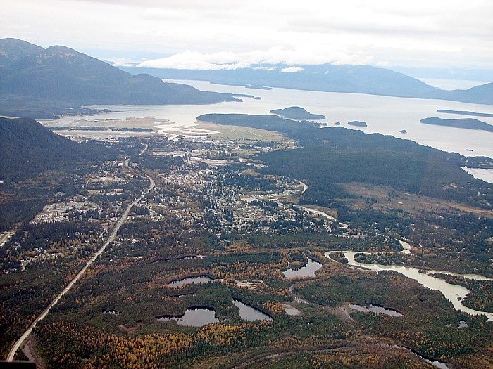
Picture taken from a helicopter over Mendenhall Lake looking SW.
Foreground: U.S.D.A. Forest Service Mendenhall Glacier Recreation Area. Counter-clockwise from lower right: Mendenhall River, West Mendenhall Valley – stretching into the Mendenhall Peninsula in the upper center of the picture, Auke Lake (only a small portion showing), Auke Bay, Coghlan Island, and Portland Island, Stephens Passage is the main body of water seen, Admiralty Island runs across the top with it’s mountains in the clouds – a tiny portion of Lynn Canal and Icy Strait with Chichagof Island visible on the far side, 33 miles from the camera, can be seen over the saddle between Admiralty Island’s Mansfield Peninsula at the right edge of the picture and the main mass of Admiralty. Continuing counter-clockwise: The northwest end of 17 mile long Douglas Island is at the upper left corner with Fritz Cove between it and the end of the Mendenhall Peninsula, next comes the Juneau International Airport Runway and then the SW end of Thunder Mountain/Heintzleman Ridge. The East Mendenhall Valley, which is where a large part of Juneau’s population lives, is the developed area visible in the central portion of the picture. Mendenhall Loop Road is the main arterial seen and becomes Glacier Spur Road where it then enters the Recreation Area.
Picture by David Kent, 10:50 a.m. ADT, September 27, 2005, © 2006